p-ISSN 2622-2027
e-ISSN 2622-2035
OPTIMIZATION TO MINIMIZING DISTANCE CARS OF FIRE EXPORTER IN INDUSTRIAL REGION SIER SURABAYA
Muhamad Abdul Jumali *) *)
Industrial Engineering Department, Faculty of Industrial Technology University of PGRI Adi Buana Surabaya
email :[email protected]
Abstract
Various fire infrastructure in Surabaya has been built, but the number of fire incident is less suitable with the standard of disaster response time. This study was conducted to determine the distribution of minimization of fire engine mileage in SIER Industrial Area of Surabaya. The analytical method used is qualitative descriptive by comparing existing condition, criteria, and policy review that exist in SIER Industrial Area of Surabaya with data of fire service post service in Surabaya City to know unreached area of fire post service and have high risk potential Will be a fire disaster in the SIER Industrial Area of Surabaya. Next determine the factors and criteria for determining the location of firefighting post based on existing policy studies and conditions. Factors determining the location of firefighting in Surabaya City is a function of the building based on the type of land use, the density of the net population, the density of the building, the range of fire service, the radius of the water supply range, the incidence of fire, the time of fire disaster response, the availability of land, and the class of road. The result of this research is the implementation of building protection management on building function in industrial area, procurement of socialization and education of fire prevention for the community, coordinating with traffic police to facilitate path of location achievement.
Keywords: distribution, firefighting post, location , potential risk.
1. Introduction
Several incidents of urban fires such as Jakarta, Surabaya, Semarang, Medan and many others have claimed casualties because the victims were unable to get out of the building
where the fires were due to physical limitations, especially in industrial areas that employ many workers. The incident caused the death toll could not be recognized because there are burns all over the body.
Setting the location of the fire station as
an emergency service facilityrequiresspecialconsiderations. So far
62|TiBuana, Vol. 01, No. 1, 2018
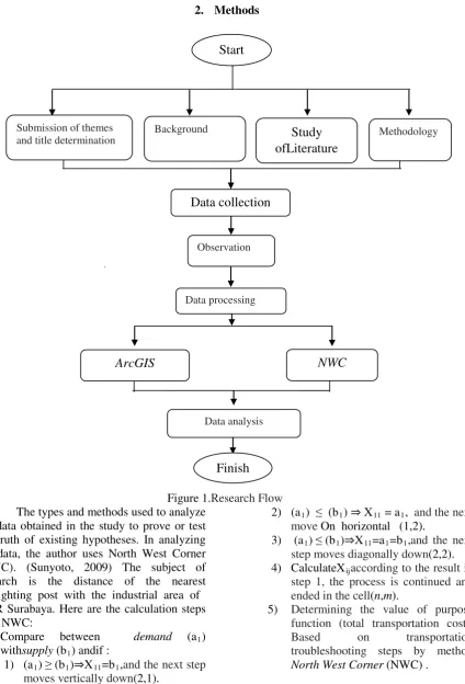
Figure 1.Research Flow The types and methods used to analyze
the data obtained in the study to prove or test the truth of existing hypotheses. In analyzing the data, the author uses North West Corner (NWC). (Sunyoto, 2009) The subject of research is the distance of the nearest firefighting post with the industrial area of SIER Surabaya. Here are the calculation steps with NWC:
A. Compare between demand (a1) withsupply (b1) andif :
1) (a1) ≥(b1)⇒X11=b1,and the next step moves vertically down(2,1).
2) (a1) ≤ (b1) ⇒ X11 = a1, and the next move On horizontal (1,2).
3) (a1) ≤(b1)⇒X11=a1=b1,and the next step moves diagonally down(2,2). 4) CalculateXijaccording to the result in
step 1, the process is continued and ended in the cell(n,m).
5) Determining the value of purpose function (total transportation cost). Based on transportation troubleshooting steps by method North West Corner (NWC) .
Start
Methodology
Study
ofLiterature
BackgroundSubmission of themes and title determination
Data collection
Observation
Data processing
NWC
ArcGIS
Data analysis
p-ISSN 2622-2027
e-ISSN 2622-2035
3. Result and discussion
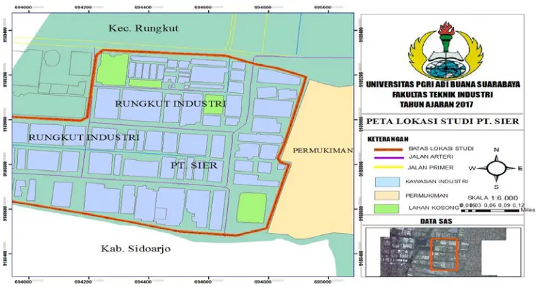
Figure 2.Map of SIER Industrial Area Surabaya .
In the picture illustrates the location of research that on the area of industrial industry SIER Surabaya
with a total area of 245 ha and is occupied by nearly 300 companies that hold tens of thousands of workers.
Table1.Postal Address Fire Brigade In Surabaya
Post office Addres Telp number
Shift I - (031) – 3533844
Shift II - (031) – 3534738
UPTD II Kenjeran 120 (031) – 3712208
UPTD III Jl. BrebekIndustri III (031) – 8411113
UPTD IV Jl. Raya MengantiWiyung (031) – 7523687
UPTD V Jl. Margomulyo Blok 1/I (031) – 7590486
Pegirian Post Jl. Pegirian No. 240 (031) – 3736945
Menur Post Jl. Menur No. 31 (031) – 5915987
Bulak Post Jl. KyaiTambakderes No.252 (031) – 51503072
PostPakal Jl. Raya Pakal No. 24 (031) – 7408134
64|TiBuana, Vol. 01, No. 1, 2018
firefighters which enable to reach the industrial area of SIER is fire station Rungkut Industri XIV/8 and fire station Brebek. Distance from Damkar Rungkut Industri XIV/8 to SIER 4.7 KM. The distance from the Brebek fire extinguisher post to SIER 2.2 KM.Analysis of the direction of the distribution of firefighting locations is done descriptively qualitative. Descriptive analysis is done after knowing the suitability between the factors studied with the
analysis is done by comparing the areas that have not reached the postal service of firefighters and have a high risk potential for fire disaster in SIER Industrial Area Surabaya with criteria determining the location of the firefighting post that has beendone.This analysis is aimed to obtain direction of distribution of firefighting post location based on potential disaster risk of fire at SIER Industrial Area of Surabaya
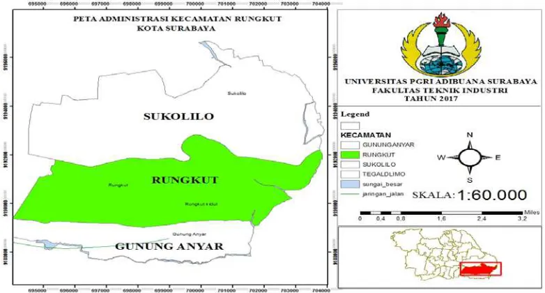
Figure 3.Map of District of Rungkut
In the picture the map depicts Sukolilo, Rungkut and Gunung Anyar districts. In this research focuses on SIER Industrial area Surabaya located in District Rungkut. Regions
p-ISSN 2622-2027
e-ISSN 2622-2035
Figure 4.GIS Map of SIER Industrial Estate and Brebek
By using arcGIS can be in the know lane, distance and hazard prone areas in the area of SIER Industry and industrial area of Brebek. Location of firefighting post itself there are two of the fire extinguisher Brebek and firefighters Rungkut Industri with a distance to the SIER Industrial area respectively is 2,2 km and 4,2 km. From
this data in the data can be densely populated residential areas located in the vicinity of industrial areas that have the potential of fire-prone karna distance in the area of industrial areas. Also described there are jammed roads, arterial roads and also residential roads.
Figure 5.GIS Map of SIER Industrial Area Surabaya The picture above illustrates the location of
SIER Surabaya industrial area which has an area of 245 ha and is occupied by nearly 300 companies that hold tens of thousands of workers. The industrial area of SEER itself
66|TiBuana, Vol. 01, No. 1, 2018
location water damkar post
DamkarPostbrebek 2 2,2 km 8.000 L 30
PostRungkutIndustri XIV/8
1 4,2 km 5.000 L 15
Source : Data processing, 2017
Data processing used in this research is usingNWCwith the following calculation:
Table 3.Calculation NWC step 1
A B C Total
Rungkut 50
Brebek 75
Total 40 45 40 125
Source : Data processing, 2017
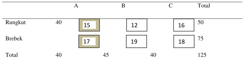
First step, fullfill the request A [40] with post damkar Rungkut [15] (so post damkar Rungkut still left 25)
Table 4. Calculation NWC step 2
A B C Total
Rungkut 40 50
Brebek 75
Total 40 45 40 125
Source : Data processing, 2017
Alternative request of road through line A has been fulfilled, hence from that alternative road through path A we make that alternative way through path A not will be included in the next
calculation. Continue to meet the demand of Rungkut city [12], take the remaining capacity of Rungkut [25]
15 12 16
17 19 18
15 12 16
p-ISSN 2622-2027
e-ISSN 2622-2035
Table 5.Calculation NWC step 3
A B C Total
Rungkut 40 10 50
Brebek 75
Total 40 45 40 125
Source : Data processing , 2017
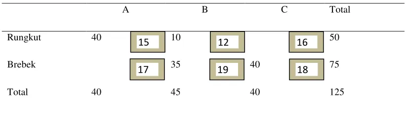
Request Rungkut has been fulfilled, then Rungkut we shading as a markerthat Rungkut will not be included in the next calculation
Table 6.Calculation NWC step 4
A B C Totall
Rungkut 40 10 50
Brebek 35 75
Total 40 45 40 125
Source : Data processing , 2017
Furthermore, to fulfill the alternatives of path B we fill by filling [35] at Brebek, so it is on Brebek
a marker that Berbek passes through path B will not be included in the next calculation.
Table 7.Calculation NWC step 5
A B C Total
Rungkut 40 10 50
Brebek 35 40 75
Total 40 45 40 125
Source : Data processing , 2017
Furthermore, to fulfill the alternative of the C path we fill it by filling [40] at Brebek, so in
Brebek passing through the C line we shade as a marker that Brebek passing through line C will not
15 12 16
17 19 18
15 12 16
17 19 18
15 12 16
68|TiBuana, Vol. 01, No. 1, 2018
From the results of the analysis of the discussion that has been described, it can be concluded that to determine the closest distance for the distribution of fire trucks in the industrial area of SIER Surabaya can use the application in GIS by using NWC calculation which will be applied to form the recommendation point of the fire station and its rangeusing NWC calculations which will be applied to form the fire fighting recommendation point and its range is more optimal, and in determining the location of public facilities must meet several criteria, among others:
• The criteria for minimizing the average distance traveled by residents from
• If the population around the service center is the same, then the burden borne by the service center should also be the same. • The service center should be able to meet
the capacity threshold value if the population around the service center exceeds the specified limits
Factors that influence the determination of the location of firefighting post are accessibility (mileage, travel time and road capacity), fire risk level (land use intensity and land use), population, service effectiveness (level and service scale, distribution pattern of existing facility ) and policies.
5. Reference
1. Bogir, Mohammad. 2009. Model Optimasi Lokasi Pos Pemadam Kebakaran (SK : Kota Semarang). Skripsi Jurusan Perencanaan Wilayah dan Kota. Semarang. Universitas Diponegoro.
2. http://surabaya.go.id/home/dishub
3. KetentuanTeknisPengamananTerhadapBa hayaKebakaranPadaBangunanGedu
ngdanLingkungan,
YayasanBadanPenerbit PU. Jakarta. 4. Sunyoto, Danang, “Dasar - dasar
matematika ekonomi terapan “,Total Media, Yogyakarta, 2009 5. Widiyanto, Wirawan. “Pemintakatan