A NEW TOOL FOR FACILITATING THE RETRIEVAL AND RECORDING OF
THE PLACE NAME CULTURAL HERITAGE
C. Bozzini a, *, M. Conedera b, P. Krebs b
a
Repertorio Toponomastico Ticinese, Archivio di Stato, Bellinzona, Switzerland – [email protected] b
Swiss Federal Research Institute WSL, Insubric Ecosystem Group, Bellinzona, Switzerland – (marco.conedera, patrik.krebs)@wsl.ch
KEY WORDS: place names, landscape hystory, monofotogrammetry, monoplotting
ABSTRACT:
Traditional place names (toponyms) represent the immaterial cultural heritage of past land uses, particular characteristics of the territory, landscape related events or inhabitants, as well as related cultural and religious background. In Euopean countries where the cultural landscape has a very long history, this heritage is particularly considerable. Often most of the detailed knowledge about traditional place names and their precise localization is non-written and familiar only to old local native persons who experienced the former rural civilization. In the next future this important heritage will be seriously threatened because of the physical disappearance of its living custodians. One of the major problems that one has to face, when trying to trace and document the knowledge related to place names and their localization, is to translate the memory and the former landscape experiences of the respondents into maps and structured records. In this contribution we present a new tool based on the monoplotting principle and ad hoc developed to enable the synchronization of terrestrial oblique landscape pictures with the represented digital elevation model. The local respondents are then just asked to show the place name localization on historical landscape pictures they are familiar with. The tool automatically gives back the corresponding world coordinates, what makes the interviewing process more rapid and smooth as well as motivating and less stress-inducing for the informants.
* Corresponding author.
INTRODUCTION
1.1 Place names as a cultural heritage
Bas Pedroli (Director of UNISCAPE, European Network of Universities for the implementation of the European Landscape Convention), defined toponyms as “signs of people’s perception
of the landscape, giving a name to its function, its form, its inhabitants, its spiritual value or the events occurred. They can
be read as a book, telling stories about the landscape’s
biography, but there are always riddles and hidden meanings, which makes it often to a gentle surprise reading them. That is the nice thing about landscape, it keeps surprising us. People express their feelings in the names they give to the places. No
people, no feelings – no feelings, no toponyms – no toponyms,
no landscape. In the landscape’s biography mankind’s
biography finds a reflection”.
Due to such a genesis, place names represent also an abstraction and a reduction of the complexity of a topographic place to a name distortion during oral transmission (Kadmon, 2000). Toponyms that survive changes in the original feature are likely to become historical documents and reflect their cultural heritage of past land uses, particular characteristics of the territory, landscape related events or inhabitants.
1.2 An endangered scientific potential
Place names may also provide important basic information on different scientific fields such as archaeology, settlement history, population history, economic history, landscape ecology and botany. In addition, recent developments in computer-aided analysis, especially using Geographical Information Systems (GIS), have improved the possibilities of analyses of the spatial distribution of toponyms with similar names or with similar semantic meaning. To this purpose however, georeferenced and spatial complete geographical information is necessary.
Unfortunately, most of the detailed knowledge about place names and their precise localization is non-written and is familiar only to old local native persons who experienced the former rural civilization. One of the major problems that one has to face, when trying to trace and document the knowledge related to place names and their localization, is to translate the memory and the former landscape experiences of the respondents into maps and structured records. In addition, this important heritage will be seriously threatened because of the physical disappearance of its living custodians in the next future.
Any tool for assisting data collection making the interviewing process more rapid, smooth, reliable, and less stress-inducing for the informants is therefore welcome.
In this contribution we present the solution adopted by the
Repertorio Toponomastico Ticinese (the toponymic repository
of Canton Ticino) that developed a new ad hoc tool based on the monoplotting principle enabling local respondents to show the place name localization directly on historical landscape pictures they are familiar with.
International Archives of the Photogrammetry, Remote Sensing and Spatial Information Sciences, Volume XL-5/W2, 2013 XXIV International CIPA Symposium, 2 – 6 September 2013, Strasbourg, France
PRESENT COLLECTING PROCEDURE
2.1 The Repertorio Toponomastico Ticinese
The Repertorio toponomastico ticinese is concerned with
collecting, protecting and enhancing the heritage of the toponyms of Ticino. The Canton Ticino is one of the 26 cantons composing Switzerland, is the only full-Italian-speaking Swiss canton and is located south of the Alps at the border with Lombardy and Piemont (Figure 1). It covers an area of 2.800 km2, ranging from the 200 m above sea level of the lake Maggiore, to the 3.400 m asl of the Adula, the highest mountain. The residents are currently around 340.000.
Figure 1: The Italian-speaking part of Switzerland and the territory of the Canton Ticino where the Repertorio
toponomastico ticinese deals with collecting and cataloguing
the toponymic heritage since 1960.
2.2 Place names in Ticino, state of the art
Place names in Ticino are collected at municipality level. Although there is a municipality merging process ongoing, it is referred to the 1995 state, counting for 245 units.
In a first step at the beginning of the 1960ies a complete rapid survey was performed on the whole territory collecting a first list of approximately 70.000 place names including their description but without any precise georeferenciation.
In a second step, each municipal territory is analyzed in detail, place name lists are completed, controlled, and described in detail, including a precise georeferenciation.
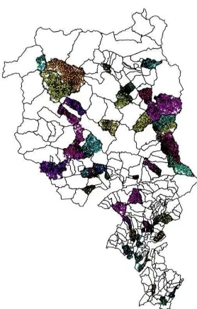
At the present time (July 2013), 50 municipalities have been
processed for a total of 30’000 full described and published
place names (Figure 2).
2.3 Data source and georeferencing procedure
In order to complete the 1960’s place name lists (first step),
different data sources are consulted such as public or private archives, old cadastral maps, and estate registers.
Figure 2. Present state of progress in reviewing and publishing the toponymic heritage of Canton Ticino. In 50 municipalities,
covering around 800 km2, 30.000 place names have been georeferenced and published
For place names not reported on maps or other spatial explicit documents, the only possible georeferencing procedure is the detailed information provided by local informants who lived or are still living in the concerned territory. Unfortunately most of such informants are old local farmers or hunters who neither are fit for field survey nor familiar in reading and orienting maps (Figure 3). As a consequence interviews with local informants for georeferencing on maps place names are stressful for the informant and quite time consuming for the interviewer. A slight improvement to this procedure is represented by the use of orthophotos, where more intuitive landscape features replace the abstract and not familiar map symbols. Our experience shows that passing from maps to orthophotos one can enhance the georeferencing procedure, reducing the stress load on the informant. Drawback of orthophotos is the aerial perspective which does not correspond to the landscape experience of the informants and the quite recent epoch represented that is a time in which the traditional land-use related landscape already disappeared (Figure 4).
USE OF TERRESTRIAL HISTORICAL PICTURES
3.1 An unexploited data source
Soon after its early development in the first half of the nineteenth century, photography became very popular as an effective method of documenting landscape features and dynamics. The quality of these historical pictures is often impressive owing to the very high resolution that was possible using photographic glass plates and other classic types of support and film. All this heritage of old photographs represents an enormous resource for the study of landscape evolution and land use change, including also place name locations and characteristics (Hendrick, Copenheaver, 2009, Kull, 2005). International Archives of the Photogrammetry, Remote Sensing and Spatial Information Sciences, Volume XL-5/W2, 2013
XXIV International CIPA Symposium, 2 – 6 September 2013, Strasbourg, France
Figure 3: On a 1:25.000 map the localization of place names is far from being self-intelligible for normal people who are not familiar in reading and orienting maps and may fail in giving
precise information. (© Swisstopo)
Figure 4: Localization of place names on recent orthophotos may reach a good precision, but many of the sites are hardly recognizable because of the new colonization by forests.
(© Swisstopo)
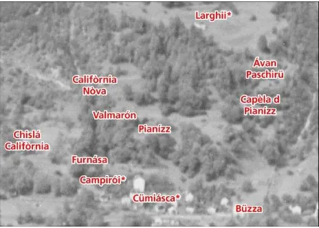
Figure 5: Precise localization of place names on a historical terrestrial picture. Most sites are perfectly recognizable in their
original shape before the abandonment of traditional land-use. (© Swisstopo)
Terrestrial historical photographs additionally present the unique advantage of reproducing the landscape under human’s everyday perspective and perception. This makes not only the localisation of the place names on the picture easier, but in many cases also recall additional details to the memory of the informants (Figure 5).
3.2 Monoplotting principle and place name georeferencing
In recent times, the general increase in computing power [5], the improvements in digital elevation models (DEM) [6,8], as well as the implementation of user-friendly and versatile releases of the Geographic Information Systems (GIS) have opened new perspectives for a broad use of single terrestrial oblique pictures for photogrammetric purposes (monoplotting). Following this perspective, Bozzini et al. (Bozzini et al., 2011a, Bozzini et al., 2011b, Bozzini et al., 2012a), developed a new monoplotting tool offering, an intuitive platform for georeferencing recent and historical terrestrial oblique photographs. The tool demonstrated so far to be accessible, easy to handle and suitable for different applications (Bozzini et al., 2012b, Conedera et al. 2013).
In particular the platform enables monophotogrammetric and geographic measurements, as well as editing of map data directly onto the picture perspective. This data may be exchanged with the most common GIS packages.
When the system is set up, informants are just asked to show the location of the toponyms on the historical picture and the correspondent real coordinates are automatically entered in the system.
3.3 Selecting the most suitable georeferencing support
Calibrating a historical picture in a monoplotting system is not extreme time consuming (Conedera et al. 2013), but requires a certain time investment. In addition, suitable historical pictures do not exist for the whole territory. It is thus important to always select the most appropriate approach when starting to interview informants. Beside the non-natural perpendicular perspective high resolution landscape orthophotos referring to presently open landscape may reveal to be a very useful and easy to handle support for a precise place name georeferentiation. Historical picture should therefore be taken in account especially where the territory dramatically evolved both towards an abandoned and dense forested landscape or towards a constructed and dense settled residence area.
CONCLUSION
First experiences with a monoplotting-assisted set up of historical picture for georeferencing place names are very promising. Informants do not have to face the difficulty of orienting the maps or orthophotos and usually enjoy the possibility of studying the historical landscape. This recalls additional information enhancing both the motivation of the informants and the precision of their statements.
In future we plan to increases the versatility of the tools by adding the option of georeferencing not only point-coordinates but also more complex spatial features such as polylines and polygons so as to precisely map the extension of toponyms corresponding to linear landscape elements (e.g. paths, rivers) and to particular zones of the territory (e.g. pasture areas, marshy areas, forests).
International Archives of the Photogrammetry, Remote Sensing and Spatial Information Sciences, Volume XL-5/W2, 2013 XXIV International CIPA Symposium, 2 – 6 September 2013, Strasbourg, France
REFERENCES
Bozzini, C.; Conedera, M.; Krebs, P., 2011a. A new tool for obtaining cartographic georeferenced data from single oblique
photos. In: Pavelka, K. (ed) XXIIIrd International CIPA
Symposium Prague, Czech Republic, September 12-16, 2011. Prague, CIPA, 6 p.
Bozzini, C.; Conedera, M.; Krebs, P., 2011b: Ein neues Tool zur Georeferenzierung und Interpretation von terrestrischen
Schrägbildern. Newsletter e-geo.ch 27, 4, pp. 16-17.
Bozzini, C.; Krebs, P.; Conedera, M., 2012a. Ein neues Tool
zur Georeferenzierung und Orthorektifizierung von
terrestrischen Schrägbildern. Geomatik Schweiz 110, 4, pp.
159-161.
Bozzini, C.; Conedera, M.; Krebs, P., 2012b: A New Monoplotting Tool to Extract Georeferenced Vector Data and Orthorectified Raster Data from Oblique Non-Metric
Photographs. International Journal of Heritage in the Digital
Era 1, 3, pp. 500-518.
Chessex, P., 1945. L’origine et le sens des noms de lieux, Neuchâtel-Paris, 62 pp.
Conedera, M., Bozzini, C., Scapozza, C., Rè, L., Ryter, U., Krebs, P., 2013. Anwendungspotenzial des
WSL-Monoplotting-Tools im Naturgefahrenmanagement. Schweiz Z Forstwes 164 (2013) 7, pp. 173–180
Hendrick, L.E., Copenheaver, C.A., 2009. Using repeat landscape photography to assess vegetation changes in rural communities of the Southern Appalachian Mountains in
Virginia, USA. Mountain Research and Development, 29,1, pp.
21-29.
Kadmon, N., 2000. Toponymy: The Lore, Laws and Language
of Geographical Names. New York, 333 pp.
Kull, C.A., 2005. Historical landscape repeat photography as a
tool for land use change research. Norwegian Journal of
Geography, 59(2005), pp. 253-268.
International Archives of the Photogrammetry, Remote Sensing and Spatial Information Sciences, Volume XL-5/W2, 2013 XXIV International CIPA Symposium, 2 – 6 September 2013, Strasbourg, France