Aquidneck Island Resilience Strategy Issue Paper 2
Issue: TRANSPORTATION
Description of Concern: Aquidneck Island encompasses a 38 square mile area, including three
municipalities, all supported by an extensive transportation infrastructure system. The road system consists of 137.3 miles of state, municipal and privately maintained thoroughfares. The three municipal governments must coordinate with the Rhode Island Department of Transportation (RIDOT), the Rhode Island Public Transit Authority (RIPTA), and the Rhode Island Bridge and Turnpike Authority (RITBA) depending on the issue. With three bridgesconnecting it to the mainland, all subject to closure under adverse conditions, the unique island geography presents challenges for both its population and governments.
Over the years, sections of roadways across Aquidneck Island have experienced flooding during extreme moon tides and storm events. These flooding scenarios are likely to become more extreme and widespread as the rate of sea level rise and storm intensity increases. In combination with storm surge events, such as a 100-year storm scenario, sea level rise could cause coastal waters to reach even further inland, magnifying the potential damage caused by coastal inundation. Beyond
surface flooding on roadways, increased volumes of water flowing around bridge foundations and being restricted by bridge abutments result in accelerated deterioration and damage this cannot be readily seen. When older infrastructure was built, the design standards didn’t anticipate a system that would be
increasingly more stressful. As a result agencies like RIDOT have a growing list of costly repair projects and must build to increasingly robust specifications.
Discussions with a range of Aquidneck Island stakeholders have revealed the following issues and concerns related to the topic of transportation and circulation on Aquidneck Island:
1) There are specific locations where transportation is being impacted today by coastal threats and this is likely to increase in the near future. (Roads identified below)
2) Bridges represent a bottleneck where transportation on and off-island can be impeded, or cut off entirely. RITBA’s policy is to close the Pell and Mount Hope Bridge to all traffic during sustained winds of 69 mph. This has widespread implications for everything from basic daily activities to emergency response. (Bridge vulnerability priorities are identified below)
3) Ownership of transportation infrastructure (ie. state vs. municipal vs. private roads) makes maintenance responsibility complicated, as well as confusing for the public.
4) Automobile transportation remains the primary means of conveyance, the result is a system with volume that has outgrown the Island’s current capacity, and increased reliance on roads that may be vulnerable to flooding.
5) Increasing storm frequency and intensity will result in more flooding. This has already increased the strain on bridge foundations and roads. Not all of these effects are visible.
6) Flooding of roadways in
economically vital areas (ie. tourism areas, commercial regions), as well as any general disruption of circulation, could hinder the island-wide economy.
Background:
Transportation is critical
element of any community’s continued existence, and Aquidneck Island is no exception. Over time issues, threats and priorities evolve and the plans in place to facilitate efficient transportation systems have evolved as well. As conditions change and the Aquidneck Island municipalities adapt coordinated planning and action will be required to take into account a changing coastal environment.
Transportation 2035
The State of Rhode Island’s long term transportation plan begins with the following vision statement :
..Transportation connects the state with the global and regional economies, the home with the workplace, the individual with the community, and all of us with one another. It must equitably benefit all communities, and must be reconciled with quality of life issues as vital as the air we breathe, the water we drink, and the preservation of our natural and historic heritage and beauty of the natural and built environments. It cannot exist independently of these concerns.
Municipal Comprehensive Plans
The themes identified in Transportation 2035 are echoed in the comprehensive plans across Aquidneck Island. Newport strives to balance its iconic cultural identify and residential community quality of life with its lucrative annual tourist influx. Middletown seeks to find more efficient means to support its thriving business community, diversify modes of transportation and encourage “complete streets.” Portsmouth is in the process of updating their plan, and envisions a balanced approach that benefits both residents, business and the environment.
Beyond the need for convenient transportation systems for commuters and visitors, municipalities are responsible for ensuring that the safety of their community is maintained. With sea level rise
Figure 2. Miles of Road Exposed on Aquidneck Island
Figure 3. Miles of Coastal Evacuation Route Exposed on Aquidneck Island
Total 25‐year Storm
Aquidneck Island Transportation Study
In 2011, Aquidneck Island Planning commission completed a detailed assessment of transportation island-wide. The report went into great detail in its analysis of transportation features, beyond roads and railways, to include bike paths and pedestrian thoroughfares. The report made specific recommendations for planners and policy makers, many of which were implemented.
Statewide Transportation Vulnerability Study
In 2016, Rhode Island Statewide Planning completed a study titled, Vulnerability of Municipal Transportation Assets to Sea Level Rise and Storm Surge. The vulnerability assessment quantified the extent to which roads and bridges throughout the state are exposed to flooding and established priority rankings for each individual structure. These rankings took into account the importance of the roadway to the community and then analyzed the extent of inundation under various sea level rise. In addition the roads and bridges were assessed under the sea level rise scenarios combined with a100 year storm surge.
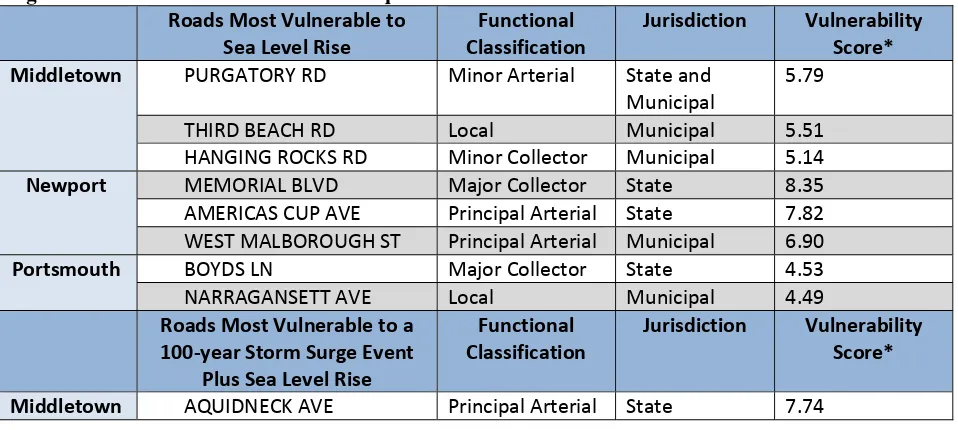
Figure 4. Most Vulnerable* Roads on Aquidneck Island
Roads Most Vulnerable to WEST MALBOROUGH ST Principal Arterial Municipal 6.90
Portsmouth
BOYDS LN Major Collector State 4.53 NARRAGANSETT AVE Local Municipal 4.49
Roads Most Vulnerable to a
PURGATORY RD Principal Arterial State and WEST MARLBOROUGH ST Principal Arterial Municipal 8.40
Portsmouth STATE HWY 24N Freeway State 8.70
MOUNT HOPE BRIDGE Principal Arterial State 7.58 STATE HWY 24 S Principal Arterial State 7.21
Figure 5. Most Vulnerable* Bridges in the Aquidneck Island Municipalities Municipality Bridges Possibly Affected by
Sea Level Rise
Portsmouth SAKONNET RIVER SAKONNET RIVER
BOYD LANE NB
BOYD LANE SB
*Vulnerability = likelihood and magnitude of hazard + social / transportation impact of the hazard occurring, values range from 0-10.
Rhode Island Statewide Planning Program’s Technical Paper 164, “Vulnerability of Transportation Assets to Sea Level Rise” (2015)
The TIP
The FFY 2017-2025 State Transportation Improvement Plan (TIP) process is the primary means by which a municipality can request funding for transportation related projects. Under a recent revision to the process, the TIP expanded from a five year plan to ten years, with an annual review of the plan giving municipalities the opportunity to request amendments. Project selection and prioritization decisions are based in part on input received by the State Planning Council from the municipalities. Based on feedback from staff at Statewide Planning, a municipality’s ability to illustrate both wide spread benefit and/or increased resilience to the effects of climate change (including sea level rise), all serve to raise the level of a project’s priorities. Additionally, there have not been any TIP submittals produced by multiple municipalities in coordination. This concept could potentially benefit the three Aquidneck Island communities if an appropriate project concept was available. The idea is not a new one, as stated in the Portsmouth Comprehensive plan (1992, revise 2002)
“As an island, the three Island communities’ transportation situations are linked.. They must work together to define and solve common transportation problems. Jointly submitted TIP applications would help strengthen each municipality’s requests.” (pg. 185)
presence of potholes. In addition, there is often confusion by residents over who (state or local government) has the responsibility to maintain which roads. The deterioration of transporation
infrastructure is an expensive issue nationwide, however the interconnectedness of the three Aquidneck Island municipalities, in terms of both vulnerability and shared interest could potentially work in the region’s favor to help resolve this issue. In the face of future coastal flooding threats, increased communication between those capable of taking action appears to be a logical first step.
Recommendations/ Potential Actions:
1) Through AIPC convene recurring meetings with municipal planners, engineers and public works representatives to discuss inter-municipal issues and opportunities. Include additional
representatives from the Naval Station, RIDOT, RIPTA and RIBTA as appropriate in order to identify mutually beneficial opportunities.
2) Coordinate between the three municipalities on a programmatic basis through the Transportation Improvement Program (TIP) process, prioritizing vulnerable roadway segments and bridges for upgrades in order to increase their resilience. (RIDOT’s 10 year transportation plan has been approved and is being incorporated into the TIP; the amendment and review process will be annual.)
3) Conduct an analysis of employee commuting patterns of major Island employers, including the Naval Station to better understand vulnerability/opportunities associated with transportation and economic drivers.
4) Diversify modes of transportation across the island. Most residents rely on cars as their primary mode of transportation (rather than utilizing a variety of transportation options such as public transportation, bicycling, and walking); therefore, encouraging a wider diversity of transportation options may lessen reliance on roadways at risk.