CONTRIBUTING OF LOCAL AREA TRAFFIC
MANAGEMENT TO REDUCE ENVIRONMENTAL
IMPACTS IN SURABAYA
Nugroho Utomo
Department of Civil Engineering
Universitas Pembangunan Nasional “Veteran” Jawa Timur, Surabaya
E-mail: [email protected]
ABSTRACT
There has been a consistent interest at both the metropolitan scale and at the local level to reduce energy consumption, relieve traffic congestion, enhance the mobility of central business areas, promote pedestrian and bicycle use. Over several years, a large amount of event relevant to local area planning in Surabaya has been required. A few considerable topics of planning, such as pedestrian movement facilities, bicycle lane planning, connected public transportations facilities, and the traffic management that are particularly applicable to local area planning and design in certain area of Surabaya especially with some objective to reduce environmental impacts such as traffic noise and air pollution. Designing the integrated plan of an environmental impact attenuation together with pedestrian lane such as buffer zone, planting vegetation and noise barriers can expected to minimizing those impacts.
Keywords: Local area traffic planning and design, environmental impacts
1. Introductions
1.1 Backgrounds
Local area planning embraces solutions for existing neighborhoods and their expansions or renovations. New developments or area improvements of cities can also be included in this category. Local area solution is a must, absolutely be followed with planning solutions at the wider metropolitan scale, through community involvement and negotiation (Black, 1981; Blunden and Black, 1984; Ogden and Bennett, 1984).
Local area planning provides vital access service to abutting lands through local street networks. In this case, local street networks are the main part of local area planning. Accessibility considerations are required by both goods and people and must be carefully managed to maintain a balance between providing all of the needed service without creating too much traffic congestion. These accessibility considerations come in many forms, including on-street parking, access to off-street parking facilities, curb lane loading zones for commercial vehicles operations, curb lanes and spaces for public transportations transit. Inclusion appropriate space and locations for these and similar types of facilities must be incorporated into a cohesive plan for a local street networks. As explained, local street networks serve a wide variety of
land-use patterns. Provision of adequate street widths and access to arterial streets is generally required for local streets to function well in such areas. The happening of complicated problems of traffic in Surabaya, for example, can be classified into three major problems.
First, is about an uncertainty of land-use planning that is executed. There are a many changes of land-use planning that permitted in downtown not due with the effect to traffic problems possibility.
Second, is about pedestrian adequate facilities. One of the related things that need more attentions on traffic engineering process in urban areas especially in Surabaya is the availability of pedestrian facilities. Generally, in residential area and in central business district (CBD) pedestrian lane representing a conflict side in frequently with traffic current. This could often make a traffic delays and affecting the pedestrian safety. From the entirety percentage of sidewalk facilities amount in Surabaya, it’s only about 30% that have a good condition and properly to use (Silas, 1996).
public transportation and of course an environmental impact such as air pollutions and highway noise could be reduced. Further, one of the next steps that must be assured to completing this plan is adequate allocation of curb lane and space should be provided among the concerned public transportations.
1.2 Objectives
The objectives of these studies are to:
- Determine a solving possibility of basic problems on local area traffic management to reduce environmental impacts in Surabaya
1.3 Formulations of Problems
Formulations of problems can be defined as mentions:
- Related with a local area traffic management to reduce environmental impacts in Surabaya, what the possible and precisely solutions that can be carried out?
2. Base of Theory
2.1 Planning for Pedestrians and Bicycle Facilities
2.1.1 Planning for Pedestrians Facilities
Particularly in urban and central business district (CBD) locations, the pedestrian presents an element of sharp conflict with vehicular traffic, resulting in high accident rates and traffic delays. Pedestrian movements and characteristics must be studied for the purpose of providing a design which minimize pedestrian – vehicle conflicts, increases pedestrian safety, and minimizes vehicle delays.
Careful assessment of demand, design standards, functional elements, and space design is required for pedestrian facility planning. It’s best to begin a study by defining the goals and objectives of the project. Safety may be the predominant objective when pedestrian-oriented commerce areas permit access to buses, taxis and operations vehicles. Pedestrian demand consists of estimating traffic volumes, traffic patterns, and composition.
Land-use patterns and building types will provide information relating with trip generation. Optimal space design may be considered as the best functional space that most economically, effectively, and safely accommodates the movements of pedestrians.
An analytical approach proposed by Benz (1987) and Fruin (1992) uses Time – Space concept, taking into the balance between time and space. Time – Space analysis is particularly applicable
in dealing with complicated cases of personal space occupancies related to pedestrian activities. Time – Space supply is the product of the time of the analysis and the area of the space being analyzed. So, the Time – Space demand is the product of the total number of pedestrians using the analysis space and their time of occupancy. The objective is to evaluate the adequacy of a given space for a forecasted peak-period demand and the occupancy time of pedestrians walking or standing in this space. By dividing the Time – Space supply by the Time – Space demand, the average area occupied per pedestrian and the corresponding Level of Service can be determined as follows:
a = average area per pedestrian (ft2/ped) within the analysis space, during the analysis period T = time of analysis period (min)
S = net effective area of analysis space (ft2) n = numbers of pedestrians occupying the space
(walking, standing, etc.)
t = predicted occupancy times of pedestrians for functions performed during the analysis period
The basic pedestrian characteristics and their application are important to planning and designing of pedestrian facilities. The basic pedestrian characteristics are:
- Pedestrian speed (average walking speed, expressed in ft/sec)
- Pedestrian flow rate (number of pedestrians passing a point per unit time, expressed as pedestrians per minute)
- Pedestrian density (average number of pedestrians per unit area within a walkway, expressed in pedestrian per ft2)
- Pedestrian space (average area provided for each pedestrian, expressed in ft2 per pedestrian)
A basic requirement of pedestrian lane width for pedestrians passing each other generally is 2.5 ft (0.75 m) width each. Pedestrians walking together may require a width of 2.2 ft (0.66 m) each. The width of walkway that can effectively be used by pedestrians is called the clear
walkway width.
pacing zone is dependent on the age, gender, and physical condition of the pedestrian. Both the pacing and sensory zones can be affected by external influences such as terrain and traffic conditions.
The relationship between pedestrian speed, density and flow relationship is expressed on this equation:
υ = S x D Where:
υ= pedestrian flow (ped/min/ft) S = pedestrian speed (ft/min) D = pedestrian density (ped/ft2)
In designing pedestrian facilities, these following factors should be considered:
- Comfort and convenience: walking distances, directness, grade on ramps, stair suitable for elderly and disabled person, directory maps, and other things that contribute to the ease of pedestrian movement
- Safety: separation of pedestrian traffic control devices from vehicular traffic that safeguard the lives of pedestrians
2.1.2 Planning for Bicycle Facilities
Although bicycle traffic composes only a small percentage of the total traffic stream, it is sufficient enough to have an impact on street design and planning. Recent accident studies have indicated that the bicyclist has been increasingly involved in vehicles with bicycle collisions. According of this fact, initiative extensive programs must provide the bicycle facilities designated as bikeways as well as bicycle lanes on streets. Now, bicycling is no longer a recreational activity, but is considered a feasible alternative of ‘eco-friendly’ mobile particularly.
Designated bicycle lanes are lanes of the street that are assigned exclusively for the use of bicycles. These lanes are separated from vehicles traffic by pavement markings. Bicycle lanes are normally placed on streets where bicycle use to move and the separation of bicycle lanes from vehicles traffic may be warranted. Bicycle lanes are generally used for flow in one direction only, with a lane provided on each side of the street. The width of on-street bicycle facilities vary widely, ranging from 4.0 ft (1.20 m) designated lane to a 10-ft (3.0 m) paved shoulder. In addition, bicycles can use space from the adjacent lane when vehicles traffic is low. It is recommended that bike-way facilities should be observed to determine the number of effective lanes. Level of service of on-street bicycle lanes
is impacted by following aspects such as light and heavy vehicle traffic, commercial and residential access road, and adjacent on-street parking.
Usually, bikeway facilities have to be planned and located to integrate with the existing street. Some important criteria used in evaluating feasible bikeway routes are as follows:
- The potential demand for the use of the route must be determined.
- The basic width needed for safe usage must be provided
- Continuity and directness of bikeway route is essential, connecting points of importance area
- Safety is a prime objective of planning. Attempts to minimize vehicles with pedestrian conflicts should be given in the main priority.
- Environmental disturbance such as heavy vehicle emissions must be considered, because carbon mono-oxide is definitely hazardous to bikeway users
2.2 Traffic Planning and Management at The Local Level
There are wide range of land-use and traffic planning problems that call for quantitative and qualitative examination ranging from commerce area to aligning the best approach to a residential area. Development applications call for meaningful traffic appraisals by local traffic engineers on a day to day measurement. Examples of traffic generation appraisals can take various forms, such as the following:
- Estimating the site’s future effects on the traffic services of existing adjacent roads - Planning a major residential area
development with an internal and external accessibility system, parking arrangements, and connecting with existing surface roads - Assuming various alternatives for proposed
changes to land-use zoning ordinances and subdivision regulations over extensive areas of the city
There are some traffic planning and management in local level that can be applied as mentions: traffic diverters, driving behavior modification, and traffic calming.
2.2.1 Traffic Diverters
patterns, such as during closures of parallel collector or arterials. However, in many situations the negative aspects outweigh the positives. Negative factors include the following: - As traffic volume build up on adjacent
parallel collectors and arterials, many drivers or the road users begin using local streets to save time and to avoid congestion.
- The increase of through trips on local streets is usually accompanied by an increase in average speed, which is undesirable along residential streets
- Environmental disturbance such as noise and air pollution created by through traffic brings an undesirable consequence to residents of the area
In order to attempting of reduce traffic loading, traffic diverters at residential intersections have begun using. The concept is simply that when through trips become numerous enough to create undesirable residents effects. Most typical residential streets operate with from 100 to 500 vehicles per day. When volumes reach 500 or 1000 vehicles per day, it is at the traffic level and any higher level that diversion techniques might be considered.
Traffic diversion is intended to accomplish one or more of the following effects:
- reduction in total vehicular traffic - reduction in average speed of traffic
- reduction in environmental disturbance such as noise and air pollution
- efficient protection for pedestrians 2.2.2 Driving Behavior Modification
Driving behavior modification is an important component of strategies for accident prevention and exposure reduction of accident occurrence. Affecting mode of transportation choice is a major behavior modification action that is hard to successfully achieve. This requires providing convenient public transportation alternatives and implementing policies that make public transportation a much more attractive alternative than driving for commuter and other types of trips. Further, by changes mode of transportation from private vehicle into public transportation can affect decreasing the rate of carbon mono-oxide gas emission from vehicles.
2.2.3 Traffic Calming
Traffic calming is a set of traffic engineering devices that are intended to solve the problems which actually occurred on local streets such as incompatibility of traffic volume and speed
levels with primary function of local streets. The specific goals of traffic calming are to:
- reduce traffic volumes on local streets - reduce traffic speeds on local streets
- reduce heavy vehicle and other commercial traffic on local streets
- reduce negative environmental impacts of traffic such as air and noise pollution
- provide a safer and more inviting environment for pedestrians and children
Traffic calming devices also contribute to better pedestrian and bicycle environments and reduce accident occurrence and severity. For example, applying of traffic calming devices in local streets is roundabouts. In terms of usage, roundabouts are generally intended to reduce speeds and also can handle relatively high traffic volumes when it properly designed.
2.3 Applying Installation of Environmental Impact Attenuation in Existing Roadside
Some environmental impact such as traffic noise and air pollution that are possible occured on existing roads can be attenuated by buffer zones, planting vegetation, and constructing noise barriers in the next of roadside.
Buffer zones are open spaces which border a highway. Buffer zones are created in addition to the normal right-of-way, so that future dwellings cannot be constructed close to the highway or roads by supported rights from local highway and roads service. This prevents the possibility of constructing dwellings that would otherwise have an excessive noise level from nearby highway traffic. An additional benefit of buffer zones is that they often improve the roadside appearance. Buffer zone usually planned along in the roadside as a green lane and planted with vegetation. By the expectation that through planting vegetation besides can reducing traffic noise it also decreasing the substance of air pollution. In the major cities like Surabaya, this buffer zone could be designed with pedestrian lane together, so an environmental impact such as traffic noise and air pollution will be minimized.
have more lands that adjacent to be developed as an earth curbs.
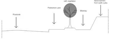
The integrated plan of pedestrian lane and bikeway that designed with buffer zone shown at figure 2.1 below:
Fig.2.1 Cross section of integrated plan of pedestrian lane, buffer zone and bikeway
And the integrated plan of pedestrian lane and bikeway that designed with buffer zone and noise barriers shown at figure 2.2 below:
Fig.2.2 Cross section of integrated plan of pedestrian lane, buffer zone, bikeway and noise
barriers
3. Summary
Related with a traffic management problem to reduce environmental impact in Surabaya, the possible and precisely solutions that can be carried out are:
1) About planning the urban facilities:
- The pedestrian must be accommodated and considered in a variety of situations. In business district or commercial area, sidewalks must be wide enough to accommodate prevalent pedestrian volumes. Where pedestrian board mass-transit vehicles, it is important that boarding times and other characteristics be studied in order to properly designed as to size and location
- In designing pedestrian and bicycle facilities, these following aspects such as comfort and convenience, safety and also security should be considered
2) About planning the traffic management at the local level:
- Traffic diversion may considered to conducted in the congested area with improving alternative road to perform reduction in total vehicular traffic,
reduction in average speed of traffic, reduction in environmental disturbance such as noise and air pollution and to protect the pedestrians efficiently
- To achieve a modification of driver behavior there are some strategies that considered to be done such as converting the usage of private vehicles into public transportations to provide an efficient travel time differential between public transportation and private vehicles by improving public transportation facilities included with it means properly. So this expected can perform minimizing environmental impact such as air pollutions and highway noise.
- Traffic calming devices can be applied in local streets on Surabaya where traffic volume and speeds highly performed. So, by this plan expected that traffic and volume reduced, making streets safer, and improving the supporting environment for pedestrians, residents and others.
3) Applying the integrated environmental impact attenuation in pedestrian lane:
- The integrated environmental impact attenuation that can be applied in pedestrian lane is buffer zone with planted vegetation. In the major cities like Surabaya, by this integrated plan expected that environmental impact such as traffic noise and air pollution will be minimized after all.
4. Bibliography
Benz, Gregory B., (1987), Transit Platform Analysis Using the Time-Space
Concept, Transportation Research
Board Record 1152, National Research Council, Washington D.C. Blunden, W.R., and Black, J.A., (1984), The
Land-Use/Transport System, 2nd ed.,
Pergamon Press, Elmsford, New York. Edwards, John D., (1992), Transportation
Planning Handbook, 4th ed., Institute
of Transportations Engineers, Prentice Hall, Englewood Cliffs, New Jersey Environment FHWA, Highway Traffic Noise
available from
http://www.fhwa.dot.gov/
environment/htnoise.htm
Federal Highway Administration, (1976), Safety and Locational Criteria for
Bicycle Facilities:Users Manual,
Federal Highway Administration, (1980)
Design of Urban Streets, U.S.
Department of Transportation, Washington D.C.
Fruin, John J., (1971), Pedestrian Planning and
Design, Prentice Hall, Englewood
Cliff, New Jersey.
Fruin, John J., (1992), Designing for
Pedestrians, Metropolitan Association
of Urban Designers and Environmental Planners, New York. Institute of Traffic and Transportation
Engineering (ITTE), (1975), Bikeway
Planning Criteria and Guidelines,
University of California at Los Angeles, Los Angeles.
Khisty, C.Jotin., Lall, B.Kent., (2003)
Transportation Engineering, Third
Edition, Pearson Education Inc., Upper Saddle River, New Jersey, USA. pp. 557-576.
Ogden, K.W., and Bennett, D.W., (1984),
Traffic Engineering Practice, 3rd ed.,
Monach University, Department of Civil Engineering, Victoria, Australia.
Pignataro, Louis J. (1973) Traffic Engineering:
Theory and Practice, First Edition,
Prentice-Hall Inc., Englewood Cliffs, New Jersey, USA.
Pline, James L., (1992), Traffic Engineering
Handbook, 4th ed., Institute of
Transportation Engineers, Prentice Hall, Englewood Cliffs, New Jersey Roess, Roger P., Prassas, Elena S., and
McShane, William R., (2004) Traffic
Engineering, Third Edition, Pearson
Education Inc., Upper Saddle River, New Jersey, USA. pp. 766-773.
Silas, Johan (1996), Kampung Surabaya
Menuju Metropolitan, First Edition,
Surabaya Post Newspaper Press. Wright, Paul H., Dixon, Karen., (2004),
Highway Engineering, Seventh
Edition, John Wiley & Sons Inc., New Jersey, USA. pp. 195-207.
U.S. Department of Transportation, Federal Highway Administration, Highway
Traffic Noise available from