Open Geospatial Consortium
Approval Date: 2012-10-12
Publication Date: 2012-12-06
External identifier of this OGC® document: http://www.opengis.net/doc/dp/moving-features-requirements
Reference number of this document: OGC 12-117r1
Category: OGC® Discussion Paper
Editor(s): Ryosuke Shibasaki (Center for Spatial Information Science, the University of Tokyo) Hiroshi Kanasugi (Earth Observation Data Integration and Fusion Research Initiative, the University of Tokyo) Akinori Asahara (Hitachi Ltd., Central Research Laboratory) Akiko Sato (Hitachi Ltd., Central Research Laboratory) Yaemi Teramoto (Hitachi Ltd., Central Research Laboratory)
Discussion Paper
OGC Standard for Moving Features; Requirements
Copyright © 2012 Open Geospatial Consortium
To obtain additional rights of use, visit http://www.opengeospatial.org/legal/.
Warning
This document is not an OGC Standard. This document is an OGC Discussion Paper and is therefore not an official position of the OGC membership. It is
OGC 12-117r1
viii Copyright © 2012 Open Geospatial Consortium
License Agreement
Permission is hereby granted by the Open Geospatial Consortium, ("Licensor"), free of charge and subject to the terms set forth below, to any person obtaining a copy of this Intellectual Property and any associated documentation, to deal in the Intellectual Property without restriction (except as set forth below), including without limitation the rights to implement, use, copy, modify, merge, publish, distribute, and/or sublicense copies of the Intellectual Property, and to permit persons to whom the Intellectual Property is furnished to do so, provided that all copyright notices on the intellectual property are retained intact and that each person to whom the Intellectual Property is furnished agrees to the terms of this Agreement.
If you modify the Intellectual Property, all copies of the modified Intellectual Property must include, in addition to the above copyright notice, a notice that the Intellectual Property includes modifications that have not been approved or adopted by LICENSOR.
THIS LICENSE IS A COPYRIGHT LICENSE ONLY, AND DOES NOT CONVEY ANY RIGHTS UNDER ANY PATENTS THAT MAY BE IN FORCE ANYWHERE IN THE WORLD.
THE INTELLECTUAL PROPERTY IS PROVIDED "AS IS", WITHOUT WARRANTY OF ANY KIND, EXPRESS OR IMPLIED, INCLUDING BUT NOT LIMITED TO THE WARRANTIES OF MERCHANTABILITY, FITNESS FOR A PARTICULAR PURPOSE, AND NONINFRINGEMENT OF THIRD PARTY RIGHTS. THE COPYRIGHT HOLDER OR HOLDERS INCLUDED IN THIS NOTICE DO NOT WARRANT THAT THE FUNCTIONS CONTAINED IN THE INTELLECTUAL PROPERTY WILL MEET YOUR REQUIREMENTS OR THAT THE OPERATION OF THE INTELLECTUAL PROPERTY WILL BE
UNINTERRUPTED OR ERROR FREE. ANY USE OF THE INTELLECTUAL PROPERTY SHALL BE MADE ENTIRELY AT THE USER’S OWN RISK. IN NO EVENT SHALL THE COPYRIGHT HOLDER OR ANY CONTRIBUTOR OF
INTELLECTUAL PROPERTY RIGHTS TO THE INTELLECTUAL PROPERTY BE LIABLE FOR ANY CLAIM, OR ANY DIRECT, SPECIAL, INDIRECT OR CONSEQUENTIAL DAMAGES, OR ANY DAMAGES WHATSOEVER RESULTING FROM ANY ALLEGED INFRINGEMENT OR ANY LOSS OF USE, DATA OR PROFITS, WHETHER IN AN ACTION OF CONTRACT, NEGLIGENCE OR UNDER ANY OTHER LEGAL THEORY, ARISING OUT OF OR IN CONNECTION WITH THE IMPLEMENTATION, USE, COMMERCIALIZATION OR PERFORMANCE OF THIS INTELLECTUAL PROPERTY.
This license is effective until terminated. You may terminate it at any time by destroying the Intellectual Property together with all copies in any form. The license will also terminate if you fail to comply with any term or condition of this Agreement. Except as provided in the following sentence, no such termination of this license shall require the termination of any third party end-user sublicense to the Intellectual Property which is in force as of the date of notice of such termination. In addition, should the Intellectual Property, or the operation of the Intellectual Property, infringe, or in LICENSOR’s sole opinion be likely to infringe, any patent, copyright, trademark or other right of a third party, you agree that LICENSOR, in its sole discretion, may terminate this license without any compensation or liability to you, your licensees or any other party. You agree upon termination of any kind to destroy or cause to be destroyed the Intellectual Property together with all copies in any form, whether held by you or by any third party.
Except as contained in this notice, the name of LICENSOR or of any other holder of a copyright in all or part of the Intellectual Property shall not be used in advertising or otherwise to promote the sale, use or other dealings in this Intellectual Property without prior written authorization of LICENSOR or such copyright holder. LICENSOR is and shall at all times be the sole entity that may authorize you or any third party to use certification marks, trademarks or other special designations to indicate compliance with any LICENSOR standards or specifications.
Contents
1 Scope ... 1
2 Why is OGC standard on moving feature necessary? ... 1
2.1 Market demand ... 1
2.2 Existing Standards for a Moving Feature ... 4
3 Requirements of a Standard on Moving Feature ... 5
4 Example Prospective Application using a Standard on Moving Features ... 5
5 Next Steps ... 7
OGC 12-117r1
viii Copyright © 2012 Open Geospatial Consortium
i.
Abstract
Applications using moving feature data, typically on vehicles and pedestrians, have recently been rapidly increasing. Innovative applications are expected to require the overlay and integration of moving feature data from different sources to create more social and business values. Efforts in this direction should be encouraged by ensuring smoother data exchange because handling and integrating moving feature data will broaden the market for geo-spatial information. This discussion paper provides an
overview of some actual and potential geo-spatial applications using moving feature data and the existing international standards or specifications on moving feature data handling. It also summarizes the requirements set on the standards for moving feature data, and finally proposes the development of a new OGC standard for moving features.
ii.
Keywords
Requirements, Implementation Specifications, Moving Features
iii.
Preface
This is an OGC discussion paper for review by the OGC members and other interested parties. It is a working report on the requirements for the implementation standards set on moving feature data. The document may be updated or replaced by other documents at any time. It is inappropriate to use OGC Discussion Papers as reference materials or to cite them as other than “work in progress.” This is a work in progress and does not imply endorsement by the OGC membership.
iv.
Submitting organizations
The following organizations submitted this discussion paper to the Open Geospatial Consortium Inc.
a) The University of Tokyo
v.
Submission contact points
All questions regarding this submission should be directed to the editor or the submitters:
CONTACT COMPANY
Ryosuke Shibasaki The University of Tokyo
Hiroshi Kanasugi The University of Tokyo
Akinori Asahara Hitachi Ltd.
Akiko Sato Hitachi Ltd.
Yaemi Teramoto Hitachi Ltd.
vi.
Revision history
Date Release Author Paragraph modified Description
2012-09-07 0.1 Ryosuke Shibasaki
All Initial Draft
vii.
Changes to the OGC
®Abstract Specification
OGC Standards for Moving Features — Requirements
1 Scope
This discussion paper provides an overview of some actual and potential geo-spatial applications using moving feature data and the existing international standards or
specifications on moving feature data handling. It summarizes the requirements set on the standards for moving feature data, and finally proposes starting the development of a new OGC standard for moving features.
2 Why is an OGC standard on moving features necessary?
2.1 Market demand
Demand is very rapidly increasing recently for better handling of moving feature data with GIS. Example applications using moving feature data include traffic congestion information services using probe cars or taxis equipped with GPS to measure the travel time of each road link, tracking systems on auto-trucks for logistics management, and agent-based road traffic simulation systems for forecasting traffic situations. Systems relying on single-source moving feature data are now evolving into more integrated systems. Integration of moving feature data from different sources is a key to developing more innovative and advanced applications. The following are examples of such efforts.
a) Integrated simulation for disaster risk management: Moving feature data is collected/integrated from different simulation systems such as people evacuation simulations, road vehicle simulations including emergency vehicles, and tsunami simulations. Many of them, except the tsunami simulations, are agent-based simulation systems that explicitly output the trajectories of individual agents, i.e., pedestrians and vehicles. A concrete example is described in Section 4. Real-time simulation and integration may be needed in support of an evacuation.
OGC 12-117r1
2 Copyright © 2012 Open Geospatial Consortium
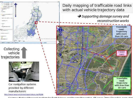
Figure 1. Identifying trafficability of road segments by aggregating vehicle trajectory data from car navigation systems.
©SAFESPOT Integrated Project
Figure 2. Local Dynamic Map (LDM)
c) Security services: This service requires the generation and sharing of situational information as a common picture by integrating and visualizing data on pedestrian and vehicle movements collected from heterogeneous sensors like surveillance cameras, GPSs, and mobile phones.
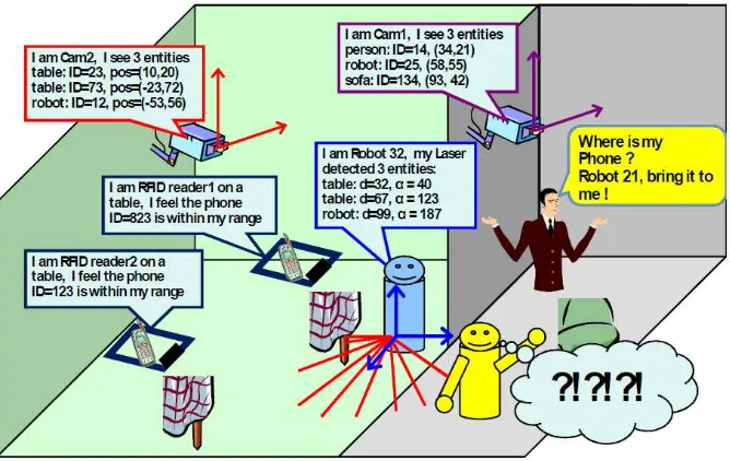
d) Navigation for Robots: Robots are expected to guide and help in the movement of elderly or handicapped people in public spaces like shopping malls (Shiomi et al., 2009). Since robots can identify only near-by obstacles and moving features with laser range and/or vision sensors, they may require situational information on a larger scale, and this requires integration of the trajectory data from the moving features collected through sensor networks. Figure 3 shows a conceptual example of moving feature data integration for guiding robots.
Figure 3. Example of typical robotic service situation requiring localization of entity (Robotic Localization Service (RLS) Version 1.1, August 2012,
http://www.omg.org/spec/RLS/1.1)
OGC 12-117r1
4 Copyright © 2012 Open Geospatial Consortium
2.2 Existing Standards for a Moving Feature
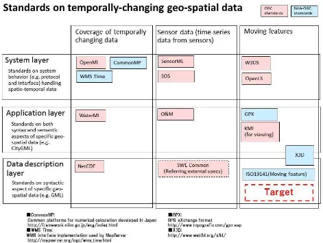
The standards for moving features, however, are insufficient. Different converters still need to be developed whenever connecting system A with system B in order to exchange moving feature data between systems. Table 1 summarizes the existing standards associated with temporally-changing geo-spatial data including moving feature data. ISO/TC211 published a standard (ISO 19141, 2008) on moving features. However, it is an abstract standard rather than an implementation specification more directly relevant for system development. OGC implementation specifications need to be developed based on ISO 19141 as indicated by “Target” in the table. The other associated standards include X3D for the visualization of moving features and GPX for describing trajectories using GPS. In addition, some of the OGC standards may be associated with moving feature data. Overlaps and consistency should be taken into account in the process of developing the OGC standards for moving features.
3 Requirements for Standards on Moving Features
The requirements for standards on moving features are summarized below.
1) “Schema for Moving Features (ISO19141, 2008)” should be referred to as the conceptual framework for this development. A standard data model should describe the movement of zero to three-dimensional geometric features including changes in attitude or rotation along with the movement.
2) The implementation specifications on moving features should be prioritized, which more directly contributes to the system development because moving feature data is becoming more popular with the very rapid growth of smart phone users worldwide, and this is strongly pushing system developers towards the integration of moving feature data rather than using the moving feature data from a single source. Implementation specifications on simple features could be a starting point. The scope of the standardization should be expanded incrementally through communication and discussions with system developers and potential users.
3) Methods specific to moving feature data handling, such as the detection of collisions, could be standardized after data model development arrives at certain level of maturity, based on further analysis of the technology and market trends.
4) Visualization and spatio-temporal interpolation of geometric features are already supported by popular standards such as X3D (http://www.web3d.org/x3d/). Unnecessary overlaps should be avoided, while popular standards should be referred to in developing a new specification on the moving features.
4 Example Prospective Application using Standard on Moving Features
As an example of the prospective applications, i.e., simulation system for tsunami evacuation, this section describes an estimation system of tsunami damage partly implemented by the authors.
OGC 12-117r1
6 Copyright © 2012 Open Geospatial Consortium
(http://upload.wikimedia.org/wikipedia/commons/thumb/5/54/SendaiAirportMarch16.jpg /1024px-SendaiAirportMarch16.jpg)
Figure 4 Sendai airport inundated by tsunami
Figure 5 Tsunami evacuation building in Nagoya city, Japan
©Hitachi, Ltd.
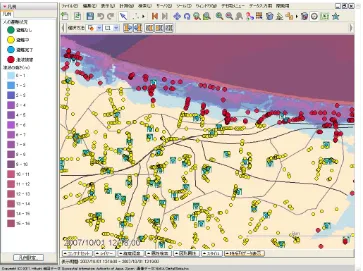
Figure 6. Example of Simulation of Evacuation from Tsunami for Coastal City with population of 600,000. The blue to purple color gradation indicates the height of the simulated tsunami. Each point denotes residents (a point for 50 people). The yellow points are evacuating people, while the red ones are people who could not escape. The green squares are tsunami evacuation buildings.
5 Next Steps
OGC 12-117r1
8 Copyright © 2012 Open Geospatial Consortium
2. ETSI TR 102 863 V1.1.1 (2011-06) DTR/ITS-0010006 Intelligent Transport Systems (ITS);Vehicular Communications; Basic Set of Applications; Local Dynamic Map (LDM); Rationale for and guidance on standardization
3. ISO/DTS 17931 (WG3) Intelligent transport systems -- Extension of map database specifications for Local Dynamic Map for applications of Cooperative ITS
4. Masahiro Shiomi, Takayuki Kanda, Dylan F. Glas, Satoru Satake, Hiroshi Ishiguro, and Norihiro Hagita, Field Trial of Networked Social Robots in a Shopping Mall, IEEE/RSJ International Conference on Intelligent Robots and Systems, 2009. 5. OGC Implementation Specification on Simple Feature (OpenGIS Implementation
Specification for Geographic information - Simple feature access - Part 1: Common architecture).