Jurnal Tata Kota dan Daerah Volume 5, Nomor 1,Juli 2013 1
SPATIAL ANALYSIS TO PREDICT CONSERVATION HERITAGE’S DAMAGE OF
“IMOGIRI GRAVES” BY USING MICROTREMOR MEASUREMENTS
Arif Gunawan, Nugroho Budi Wibowo
Urban and Regional Planning Diponegoro University Semarang
Jalan Prof Sudarto SH Tembalang Semarang Indonesia 50275 Telp.024-7460054 e-mail : [email protected]
ABSTRAK
Sari— Studi ini memberikan suatu tinjauan deskripsi secara lebih komprehensif terhadap aspek spasial terkait dampak kerusakan bencana gempa bumi pada peradaban manusia yang salah satunya adalah Kompleks Makam Imogiri. Kompleks tersebut merupakan salah satu lokasi terpenting bagi Kerajaan Mataram. Berdasarkan pada pengamatan terakhir, lokasi ini mengalami kerusakan sebagian saja akibat gempa dibandingkan wilayah lain yang terkena dampak pada Kabupaten Bantul. Dasar teori yang digunakan pada kasus ini adalah dengan menggunakan Metode Kanai untuk Ground Acceleration dan Ground Shear Stress (GSS). Selanjutnya berdasarkan dari kedua teori tersebut kita dapat melakukan analisis spasial di wilayah terkena dampak bencana gempa dengan fokus untuk komponen Peak Ground Acceleration (PGA) dan Seismic Susceptible Index (Kg)-Ground Shear Stress (GSS). Hasil akhirnya adalah: (1) daerah dengan nilai PGA 129-174 gal akan secara langsung terkait dampak kerusakan bangunannya; (2) Indeks Kerentanan Seismik (Kg) berada di bawah 20 dan mengandung arti bahwa daerah Imogiri merupakan wilayah aman (tingkat kerentanan resiko rendah).
Kata Kunci : Spasial, Mikrotremor, PGA, Kg, Imogiri
ABSTRACT
The paper gives you a description more comprehensive views to learn spatial aspect in relating to the effects of earthquake damage in human civilization which is one of them is for Imogiri Graves Area. These ones are important place for Mataram Kingdom funerals. Based on last observation, this location was partially destroyed by earthquake disaster like other places in Bantul Regency. The theories could be embedded in this cases which consists of Kanai methods for Ground Acceleration and Ground Shear Stress (GSS). Then, deriving from those we can analyze the spatial aspect of disaster prone area which emphasizing into figure out Peak Ground Acceleration (PGA) and Seismic Susceptible Index (Kg)-Ground Shear Stress (GSS) as well. The results are: (1)
PGA’s area are showed 129-174 gal and directly connected to damage ratio for buildings; (2) Seismic Susceptible Indexes (Kg) are below 20 which means Imogiri area was a safe zone (with low-risk susceptible).
Keywords: Spatial, Microtremor, PGA, Kg, Imogiri
INTRODUCTION
The Yogyakarta earthquake on May 27th 2006 had been significant impacted into daily activities from local people. There are numerous of victims people that affected directly and also as many damage as we find out about the damage of infrastructure data which are from light scale to heavy one. After that, those are made the May 27th 2006 Yogyakarta earthquake would always be remembered into one of the 21 century’s most deadly earthquake disaster in this area. Including this facts, the damage of disaster would also about the correlation of cultural heritage
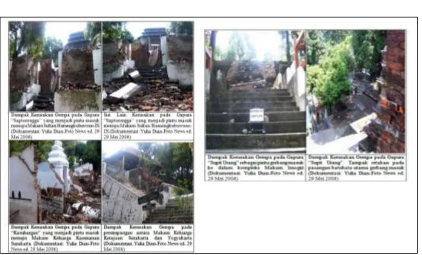
conservation from Imogiri Graves into damage hazards which is effected with earthquake disaster in the future. As we knew before, the effects from earthquake disaster in Imogiri Graves are categorized as partially failures in some of part buildings (Figure 2). Besides, it had been there since the first construction by an architect named Kyai Tumenggung Citrokusumo in the era of Sultan Agung Hanyokrokusumo in the year of 1632 (Source: Buku Panduan Pasarean Imogiri, 2000).
SPATIAL ANALYSIS TO PREDICT CONSERVATION HERITAGE’S DAMAGE OF “IMOGIRI GRAVES” BY USING MICROTREMOR MEASUREMENTS
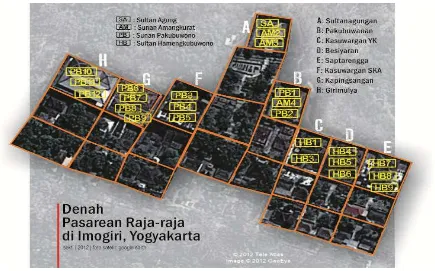
2 Jurnal Tata Kota dan Daerah Volume 5, Nomor 1, Juli 2013 various access of rung in 345 (three hundred and
forty five) totally. These funeral complex which occupied the terrain with 10 (ten) hectares in situated on Bukit Merak (which lies on Imogiri sub-district) and located at an elevation of between 35-100 (from thirty five till a hundred) meter above mean sea level.
The damage effect in Imogiri Funeral Complex, at detailed, could be explained as of below these :
1. Deeply damage at the door gate “Sapit Urang” which is opening gate into funeral of Sultan Agung at Sultanagungan complex.
2. Damage at Gate of Kasurahan (opening gate of Kasunanan pedigrees) at Pakubuwanan complex.
3. Damage at gate of Saptorongga (opening gate of Sultan Hamengkubuwono-IX tomb/grave).
4. Damage at opening gate of east side of funeral complex.
5. Damage at junction wall tomb among Surakarta and Yogyakarta funerals.
By using microtremor measurements we can use them as one of scientific approaches to assess damage ratio and natural phenomena which caused by earthquake disaster on May 27th 2006.
Assessments by this tool could be using to measure soil responses to find out how its characteristics based on the frequency values and its dominance periods. This paper has multi-purpose to know how especially for accelerate rate of soils/ rocks, seismic susceptibility index and ground shear strain at surroundings of funeral complex.
Jurnal Tata Kota dan Daerah Volume 5, Nomor 1,Juli 2013 3
RESEARCH METHOD
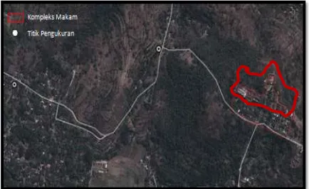
This research had been done especially only on the Imogiri graves yards and surrounding them, at Bantul regency Yogyakarta special region province by using microtremor method. This method was build on field measurement. The measurement form this one could be done on 2 (two) locations outside of Imogiri graves area. Microtremor measurement on this research was using the seismograph of TDS 303 while it is completed by digitizer, seismic sensor, data cables, GPS, compass and laptop for combining all data into information which are get ready to give us decision support. Beside that, the field data which collected before would be processed by at least 3 (three) software named Data Pro, SESSARAY-GEOPSY and Surfer. From 3 (three) software we can construct step by step all data into some information to us. The earthquake data while we used to form model of PGA (Peak Ground Acceleration) was the earthquake data form recorded on May 27th 2006. The processing of microtremor data by using Horizontal-Vertical Seismic Ratio (HVSR) method is for getting dominance frequency value (f) and amplification factor (A). Those are the 2 (two) variables/ components of HVSR method which are more significant to explain how microtremor happen as a scientific phenomena. And lastly, those are derived in order to get input variable model of PGA and GSS (Ground Shear Stress) as well.
Basic Theory
1. Ground Accelerationby Kanai Methods (1966)
whereas :
ag = ground acceleration (gal) T0 = soil dominant period (second) M = Magnitude (Richter scale) R = distance (km)
2. Ground Shear Strain
Ground shear strain on surfaces soil which is described adaptability of soil material for each stretch or shift when earthquake disaster happened.
Table 1. Natural Phenomena which is happened based on shear strain values
Sources: Wald (1999)
Figure 2. Documentation Records of Damage at Imogiri Funeral Complex (Source: Yulia Dian-Foto News online)
Jurnal Tata Kota dan Daerah Volume 5, Nomor 1,Juli 2013 4 Which the Formula:
Whereas: (Kg is a seismic
susceptibility index, Ag is an amplification factor and Fg is more dominant frequency), and (Vb is for velocity on basement), is related by ground shear strain also for ground acceleration (gal).
Figure 3. The Location of Sampling Methods of Microtremor at surrounding of Imogiri Funerals.
(Red Line : Funerals complex; White dots : measurement samplings)
RESULT AND DISCUSSION
The 2006 Yogyakarta Earthquake gives a warning and learning about quick and stepped out response for earthquake disaster management. Yogyakarta has also one of some provinces that occupy directly by Indian Ocean and lies on not far from subduction zones between Indo-Australia and Eurasia plates. This condition made it has had higher risks against earthquake hazards in the future than recently.
Yogyakarta is one of cities that have various kinds with too many cultural heritage sites and number of them and also has had high historical values. One of them is Imogiri Funeral Complex which lies on Imogiri sub-district, Bantul regency. When viewed from the location was located in the hills and close to the track of Opak fault zones (which is re-activated by 2006 earthquake), those made this cultural heritage has a level of risks of earthquake disaster.
Peak Ground Acceleration (PGA) on Imogiri Funeral Complex
The effects of last earthquake disaster in Yogyakarta which cause significant damage are the May 27th 2006 earthquake. Data from Meteorology Climatology and Geophysics Agency (Yogyakarta station) show us that its damage by 5.9 Richter scale with a depth of 33 (thirty three) km cause damage to the IX (in scale
of MMI) for Bantul regency and Klaten (PGA). Calculation and modeling spatial of PGA which used to see the impact that occurs on Imogiri Funeral Complex after their disaster in 2006. Modeling results with surfer shows the variation of the acceleration around Imogiri complex which amounted to 129-174 gal or the intensity criteria for VI MMI.
The intensity class was based on Wald’s criteria (1999) which represented by shaking that is felt all residents, windows and cracked wall all of which is categorized as light damage (Table1). After 2006 earthquake disaster, this place suffered minor and heavy damage especially in entrance cemetery complex of Sultan Surakarta (PB). Red mark for the third observation points.
Comparative results of data due to earthquake damage to building with PGA’s model showed us a linear pattern. Area with high PGA values correlated with the ratio of damage to building (Figure 4 b,c and d). PGA sections of A-A’ and B-B’ showed that the highest PGA for tomb complex located in northern and western of those area. Distribution patterns of damage to disaster. The analysis of seismic susceptibility index (Kg) gives information about seismicity risk level based on seismic vulnerability/ susceptibility. Kg is a representation of the criteria of earthquake resistant buildings which has been issued by the Ministry of Public SPATIAL ANALYSIS TO PREDICT CONSERVATION HERITAGE’S DAMAGE OF “IMOGIRI GRAVES” BY USING MICROTREMOR MEASUREMENTS
Arif Gunawan, Nugroho Budi Wibowo
Jurnal Tata Kota dan Daerah Volume 5, Nomor 1, Juli 2013 5 130 rehabilitation and reconstruction of buildings at the earthquake-affected areas in 2006.
Other potential disasters that may occur in this region are ground movement and landslide. It can be seen from the characteristics of the location of the grave condition which is lies on hilly topography (geomorphology type: perbukitan terisolasi/isolated hills) and as for geology aspect, this place lies on Nglanggran Formation. The main rock derived from volcanic breccias, agglomerate, tuff and lavaandesit-basal flow also lava andesite. The volcanic breccias and agglomerate which are dominated onto this formation have no laminated in general.The tiles consist of andesite and slightly basalt, were sized 2 – 50 cm and shaped lenses or pieces as well. As locally, this formation inserted by volcanic
sandstone epiclastic and tuff.
In other issues, microtremor approaches by GSS analytical provides information due to potential natural phenomenon that can occur based on the magnitude of shear strain from in-situ soil and rocks. Then, regarding of analytical results on Figure 6, it indicates area of the tomb complex is at range of GSS values amounted by 0,0002 – 0,0012. Those GSS values build upon Ishihara (1978), while its values are in the range of 10-4 which means the region has the potential for ground movement as the form of surface cracking and settlement. At Imogiri Funeral Complex in the area is included in the type of fractures at different location (Pramumijoyo and Sudarno, 2008) because it is located at an altitude of 35-100 meters above the surface.
Figure 4. (a) Damage points on funeral complex, (b) Values of PGA on Section A-A’, (c) Values of
Slice tracks from model PGA
(a)
(d) (c)
Jurnal Tata Kota dan Daerah Volume 5, Nomor 1,Juli 2013 6 Section of GSS B – B’(Figure 6 (b))
indicates variation in the value of GSS which increasingly large into direction of east, they are from 0,000261 – 0,000304. Whereas the section of GSS A – A’(Figure 6 (c)) GSS values increasingly into direction of south. These data illustrates that the tomb of Imogiri region on the
slopes of the hills are as of the potential of ground movement or soil cracks .
In the middle of the formation, which is volcanic breccia, we found good layered limestone reefs. Profile condition can be observed in the field as Figure 6(e).
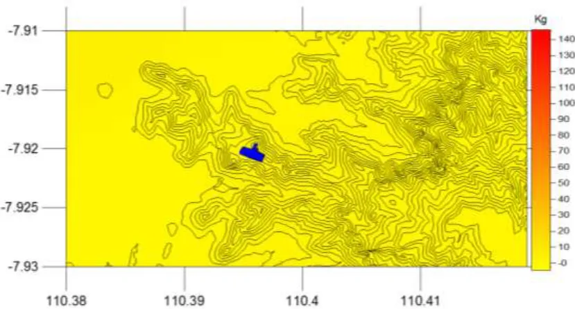
Figure 5. Model of seismic susceptibility index (Kg) around Imogiri Funeral Complex (Source: Analytical Result, 2012)
Figure 6. (a).Model of GSS around Imogiri funeral complex, (b) Graph of GSS at section of B-B’ and (c) Graph of GSS at section of A-A’ also (d) Inset section of A-A’ and B-B’ and (e) the landform unit
at tomb complex of Imogiri were Structural Hills Nglanggran Formation and the appearance of Nglanggran Formation at Bukit Merak Imogiri sub-district (Sources: Field Data, 2011dan Analytical
Results, 2012) (e)
SPATIAL ANALYSIS TO PREDICT CONSERVATION HERITAGE’S DAMAGE OF “IMOGIRI GRAVES” BY USING MICROTREMOR MEASUREMENTS
Arif Gunawan, Nugroho Budi Wibowo
Jurnal Tata Kota dan Daerah Volume 5, Nomor 1, Juli 2013 7
CONCLUSION
Based on previous explanations about peak ground acceleration analysis (PGA), seismic susceptibility index (Kg) and ground shear strain (GSS) at the sites, then we can conclude for some facts which they are:
1. Peak Ground Acceleration (PGA) values at the sites which based on data modeling vary from 129 to 174 gal or in any facts correlated equally by VI MMI-scale. The comparison data results of building damage due to 27th May 2006 earthquake by PGA model that shows a linear pattern. The area with high PGA value while directly correlated with building damage ratio (Figure 4 b,c and d). The PGA section of A-A’ and B-B’ that indicate the highest value of PGA for tomb complex in which lies on northern and western areas. Meanwhile, the distribution of building damage patterns had the west-east direction.
2. Based on the analysis of seismic vulnerability index (Kg),condition of the area in general of Imogiri Tomb complex is at low risk for severely affected directly due to earthquake disaster (below 20). However it still has the potential disaster of landslides due to the weakening of local soil and rock structure either because the settlement and development of surface cracking systems. The potential will be increasing the probability for the east and south of the tomb complex of Imogiri based on analysis to slice of cross section A-A’ and B-B’.
Recomendation
The recommendations can be proposed from this study are:
1. The existence of the tomb complex of Imogiri are appropriately conducted regular monitoring and continous relating conservation and sustainable utilization of complex functions. For that, the expected Bantul District Government and the Provincial Government of Yogyakarta Special Region (such as Dinas Pariwisata and Badan Arkeologi) could monitor and reduce potential threats in the future. 2. The study based on analysis of seismic and
other geophysical parameters is very
effective to explain the nature of physical phenomena on Earth and also in order to support efforts to reduce the risk of natural disasters (earthquake and landslide) included in this area is the Imogiri Tomb complex region.
ACKNOWLEDGEMENTS
The authors wish to thank Mr Ari Budi Nugroho as Chief of Physical and Infrastructure section at Regional Development Planning Board of Bantul Regency for his valuable comments and suggestions. Also, we are grateful to Meteorology Climatology and Geophysics Agency- Station of Yogyakarta for their microtremor tools due to supporting us at the field. Our study was initiated by the thesis of Arif Gunawan at Master of Urban and Regional Planning Diponegoro University. By this research, we need study more detail for continuing application of microtremor platforms due to spatial views in specific area like Bantul and after that more places by the same characteristics.
REFERENCES
Anonim, 2000, Buku Panduan Pasarean Imogiri, Yogyakarta.
Ishihara K and Ogawa K, 1978, Liquefaction Susceptibility Map of Downtown Tokyo. Proc. Of the 2nd International Conference on Microzonation . vol.2. Keputusan Menteri Pekerjaan Umum Nomor
19/PRT/2006 tentang Pedoman Rekonstruksi dan Rehabilitasi Rumah Pasca Gempabumi di wilayah Provinsi D.I. Yogyakarta dan Provinsi Jawa Tengah.
SPATIAL ANALYSIS TO PREDICT CONSERVATION HERITAGE’S DAMAGE OF “IMOGIRI GRAVES” BY USING MICROTREMOR MEASUREMENTS