Submit to Remote Sensing Login Register MDPI Journals A-Z Information & Guidelines About Open Access Policy
I M P A C T F A C T O R 3 . 18 0
Title / Keyword Journal Remote Sensing Volume
Author Section -- Issue Clear
Article Type all Special Issue all Page Search
Remote Sensing — Editors
Journal Contact
Remote Sensing Editorial Office
MDPI AG, Klybeckstrasse 64, 4057 Basel, Switzerland E-Mail: [email protected]
Research Geographer-15, U. S. Geological Survey (USGS), USGS Western Geographic Science Center (WGSC), 2255, N. Gemini Dr., Flagstaff, AZ 86001, USA
Tel. +94-11-2788924; Fax: +1 928 556 7112 Website: http://profile.usgs.gov/pthenkabail E-Mail: [email protected]
Interests: hyperspectral remote sensing, remote sensing expertise in a number of areas including: (a) global croplands, (b)
agriculture, (c) water resources, (d) wetlands, (e) droughts, (f) land use/land cover, (g) forestry, (h) natural resources management, (i) environments, (j) vegetation, and (k) characterization of large river basins and deltas
Contribution
Associate Editor
Prof. Dr. Clement Atzberger
Head Surveying, Remote Sensing & Land Information (IVFL), University of Natural Resources and Life Sciences, Vienna (BOKU), Peter Jordan Strasse 82, 1190 Vienna, Austria
Fax: +43 1 47654 5142
Website: http://www.rali.boku.ac.at/ivfl.html E-Mail: [email protected]
Interests: imaging spectroscopy; time series analysis; radiative transfer modeling (forward and inverse); retrieval of
vegtetation biophysical variables; vegetation monitoring
Contribution
Associate Editor Dr. Nicolas Baghdadi
Maison de la Télédétection, Irstea - UMR TETIS, 500 rue JF Breton, 34093 Montpellier Cedex 05, France Website: http://www.tetis.teledetection.fr/
E-Mail: [email protected]
Interests: SAR images applied to soil (surface roughness, soil moisture, texture); Lidar and Forest (canopy height and
biomass); SAR images and biomass
Associate Editor Dr. Ioannis Gitas
Laboratory of Forest Management and Remote Sensing, School of Forestry and Natural Environment, Aristotle University of Thessaloniki, Thessaloniki, Greece
Fax: +30 2310 992677 Website: http://fmrs.web.auth.gr/ E-Mail: [email protected]
Interests: forest fires; pre-fire planning and post-fire assessment; land use/land cover mapping; soil erosion risk
assessment/desertification; other environmental applications of remote sensing and GIS
Contribution
Associate Editor Dr. Richard Gloaguen
Remote Sensing Group, Helmholtz Institute Freiberg, TU Bergakademie Freiberg, Bernhard von-Cotta Str., 2, D-09599 Freiberg, Germany
Website: http://tu-freiberg.de/remote-sensing-group E-Mail: [email protected]
Interests: earth sciences; remote sensing/photogrammetry; tectonic geomorphology; vegetation physical properties;
hydrological cycle
Contribution
Associate Editor
Prof. Dr. Alfredo R. Huete
Plant Functional Biology and Climate Change Cluster, School of Environment, University of Technology Sydney, 15 Broadway Road Ultimo, NSW 2007, Australia
Website: http://www.c3.uts.edu.au/ E-Mail: [email protected]
Interests: biophysical remote sensing; phenology; satellite products; carbon and water fluxes; land use science; drought
studies
Associate Editor Dr. Yoshio Inoue
National Institute for Agro-Environmental Sciences (NIAES), Tsukuba, Ibaraki 305-8604, Japan Tel. +81-29-838-8222
Website: http://www.niaes.affrc.go.jp/researcher/inoue_y_e.html E-Mail: [email protected]
Interests: plant eco-physiology; remote sensing, modeling, agro-ecosystem; precision farming; GIS Contribution
Associate Editor Dr. Josef Kellndorfer
Senior Scientist, The Woods Hole Research Center, 149 Woods Hole Road, Falmouth, MA 02540, USA Fax: +1 (508) 444 1840
Website: http://whrc.org/about/cvs/jkellndorfer.html E-Mail: [email protected]
Interests: REDD; remote sensing; forests; climate change; high performance computing; SAR imaging; data fusion; time
series analysis
Associate Editor Dr. Norman Kerle
Department of Earth Systems Analysis (ESA), Faculty of Geo-Information Science and Earth Observation (ITC), University of Twente, P.O. Box 6, Hengelosestraat 99, 7500 AA Enschede, Netherlands
Website: http://www.itc.nl/resumes/kerle E-Mail: [email protected]
Interests: damage assessment; vulnerability; disaster risk management; UAV; resilience; recovery; OBIA; object-oriented
analysis; VGI
Associate Editor
Dr. Alexander A. Kokhanovsky
EUMETSAT, Eumetsat Allee 1, D-64295 Darmstadt, Germany E-Mail: [email protected]
Interests: remote sensing; light scattering; radiative transfer; inverse problems; atmospheric optics; retrieval of aerosol and
cloud properties from spaceborne observations
Contribution
Associate Editor Dr. Richard Müller
German Meteorological Service CM-SAF, Frankfurter Straße 135, 63067 Offenbach, Germany Fax: +49 (0) 69 8062 4955
Website: http://www.cmsaf.dwd.de/ E-Mail: [email protected]
Interests: remote sensing of surface radiation; clouds and aerosols; sensor calibration; methods for \"merging\" in-situ data
with remote sensing data
Contribution
Associate Editor Dr. Parth Sarathi Roy
University Centre of Earth & Space Science, Hyderabad Central University P.O Central University, Gachibouli, Hyderabad 500046, India
Tel. +918008504546 E-Mail: [email protected]
Interests: land use and land cover change; landscape ecology; biodiversity; land dynamic modelling; assessment of
ecological services
Associate Editor
Prof. Dr. Randolph H. Wynne
Department of Forest Resources and Environmental Conservation, Virginia Tech, Cheatham Hall, RM 319, 310 West Campus Dr, Blacksburg, VA 24061, USA
Tel. 540-231-7811
Website: http://frec.vt.edu/people/faculty/faculty_folder/wynne.html E-Mail: [email protected]
Interests: applications of remote sensing to forestry; natural resource management; ecological modeling; and earth system
science
Contribution
Associate Editor Prof. Dr. Xiao-Hai Yan
Center for Remote Sensing (CRS), College of Earth, Ocean and Environment, University of Delaware, 209 Robinson Hall, Newark, DE 19716, USA
Website: http://www.ceoe.udel.edu/people/profile.aspx?xiaohai E-Mail: [email protected]
Interests: satellite oceanography/ocean remote sensing; Physical oceanography/ocean circulation/climate change; remote
sensing of estuaries, coastal and open ocean waters; remote sensing image processing; air-sea interactions and upper ocean dynamics; mirowave remote sensing (altimeter, scatterometer and SAR); environmental remote sensing
Contribution
Senior Assistant Editor Ms. Xuanxuan Guan
MDPI Tongzhou Office, Room 2207, Jincheng Center, No. 21 Cuijingbeili, Tongzhou District, Beijing 101101, China Fax: +86 10 59011089
E-Mail: [email protected]
MDPI AG, Klybeckstrasse 64, CH-4057 Basel, Switzerland E-Mail: [email protected]
Former Editor-in-Chief Prof. Dr. Wolfgang Wagner *
Research Group Remote Sensing, Department of Geodesy and Geoinformation (GEO), Vienna University of Technology (TU Wien), Gusshausstrasse 27-29, 1040 Vienna, Austria
Fax: +43 1 58801 12299
Website: http://www.ipf.tuwien.ac.at/
Interests: remote sensing; geophysical parameter retrieval; airborne laser scanning; full-waveform lidar; radar remote
sensing; soil moisture
* Founding Editor-in-Chief and Editor-in-Chief up to 2 September 2011
Contribution
For further MDPI contacts, see here.
Editorial Board
Dr. Devrim Akca
Department of Civil Engineering, Isik University, TR-34980 Sile, Istanbul, Turkey Fax: +90 216 712 1474
Website: http://www2.isikun.edu.tr/personel/akca
Interests: sensor calibration; 3D city modeling; laserscanning; photogrammetry; machine vision; cultural and natural
heritage applications; high accuracy object measurement and 3D modeling
Contribution: Special Issue: Remote Sensing in Natural and Cultural Heritage
Dr. Sreekala Bajwa
Department of Agricultural and Biosystems Engineering North Dakota State University NDSU Dept. 7620 PO Box 6050, Fargo, ND 58108, USA
Tel. +1 701 231 7265; Fax: +1 701 231 1008 Website: http://www.ndsu.edu/aben/personnel/bajwa/
Interests: remote sensing; precision agriculture; unmanned aerial systems; bio-composites
Prof. Dr. Heiko Balzter
Holder of the Royal Society Wolfson Research Merit Award, Centre for Landscape and Climate Research, Department of Geography, University of Leicester, Bennett Building, University Road, Leicester LE1 7RH, UK
Fax: +44 116 252 3854 Website: http://www.le.ac.uk/clcr
Interests: land cover / land use change; spatial-temporal scaling; land/atmosphere interactions; data assimilation; synthetic
aperture radar (SAR); SAR interferometry; SAR polarimetry; ground-based, airborne and spaceborne light detection and ranging (LIDAR); digital elevation models; carbon accounting; forest structure and biomass mapping; vegetation phenology; fire and burned area mapping
Contribution: Special Issue: Remote Sensing and GIS for Habitat Quality Monitoring In other journals:
Special Issue: Land Use Change Feedbacks with Climate
Dr. Agnes Begue
CIRAD-UMR TETIS, Maison de la Télédétection, 500 Rue Jean François Breton, 34093 Montpellier, France Tel. +33 4 67 54 87 54
Interests: Remote sensing for agriculture applications (yield estimation, cropland mapping, precision agriculture, zoning,
cropping practices) Use of multi-source data (image time series, crop model simulations and expertise
Prof. Dr. James Campbell
Geography Department, 220 Stanger Street, 115 Major Williams Hall, Virginia Tech, Blacksburg, VA 24061, USA Tel. 540.231.5841
Website: http://geography.vt.edu/people/campbell.htm
Interests: agricultural systems (crop rotation, tillage assessment, yield estimation); soil variability; land use/land cover
change; coastal reclamation; urban systems (microclimates, impervious surfaces, drainage)
Prof. Dr. Toby N. Carlson
Professor Emeritus of Meteorology, Penn State University, 617 Walker Building, University Park, PA 16802, USA Tel. (814) 863-1582; Fax: +1 814 865 3663
Website: http://www.met.psu.edu/people/tnc
Interests: satellite remote sensing applications to regional planning; modeling of evapotranspiration over plant canopies;
land surface processes
Dr. Matthew Clark
Department of Geography and Global Studies & Center for Interdisciplinary Geospatial Analysis (CIGA), Sonoma State University, 1801 E. Cotati Ave, Rohnert Park, CA 94928, USA
Tel. 707-664-2558
Website: http://www.sonoma.edu/geoglobal/home/faculty/matthew-clark.html
Interests: remote sensing; geographic information systems; biogeography
Dr. Roberto Colombo
Remote Sensing of Environmental Dynamics Lab., Dept. of Earth and Environmental Sciences, University of Milano-Bicocca, Piazza della Scienza 1, 20126 Milan, Italy
Website: http://telerilevamento.disat.unimib.it/
Interests: remote sensing; earth observation; environmental modelling; imaging spectroscopy; field spectroscopy;
chlorophyll fluorescence; land surface phenology; bio-geophysical remote sensing
Dr. Jose Dematte
Soil Science Department, Luiz de Queiroz College of Agriculture, São Paulo, University of Piracicaba, SP 13418-900, Brazil Website: http://www.en.esalq.usp.br/
Interests: remote sensing applied to soils; soil spectroscopy, digital soil mapping, RS from ground to space, precision
Prof. Dr. Ralph Dubayah
Department of Geography, 2181 LeFrak Hall, University of Maryland, College Park MD 20742, USA Fax: +1 301 314 9299
Website: http://www.geog.umd.edu/facultyprofile/Dubayah/Ralph
Interests: lidar remote sensing; terrestrial carbon cycling; biodiversity and habitat
Prof. Dr. Giles M. Foody
School of Geography, University of Nottingham, Nottingham, NG7 2RD, UK Fax: +44 1159515249
Website: http://www.nottingham.ac.uk/~lgzwww/contacts/points/teaching.phtml?name=foody
Interests: land cover; image classification; ecology; GIS
Dr. Chandra Giri
Research Physical Scientist, USGS Earth Resources Observation and Science (EROS) Center, Nicholas School of the Environment/Duke University , A321 LSRC, Box 90328, Durham, NC 27708-0328, USA
Tel. 6055942835; Fax: +1 605 594 6529 Website: http://eros.usgs.gov/
Interests: mangrove forests mapping and monitoring using high resolution satellite data; global and continental land cover
mapping and monitoring using multi-spectral, multi-temporal, and multi-platform remotely sensed data; image pre-processing, classification, and validation using cloud computing
Contribution: Special Issue: Remote Sensing of Mangroves: Observation and Monitoring
Prof. Dr. Anatoly Gitelson
Israel Institute of Technology, 812 Rabin Hall, Technion City, Haifa 320000, Israel; School of Natural Resources, University of Nebraska - Lincoln, Lincoln, NE 68583, USA
Tel. 402 5608430
Website: http://www.calmit.unl.edu/people/agitelson2/
Interests: remote sensing of vegetation and water quality
Prof. Dr. Douglas G. Goodin
Remote Sensing Research Laboratory, Department of Geography, Kansas State University, Manhattan, KS 66506, USA Tel. 785-532-3411; Fax: +1 785 532 7310
Website: http://www.k-state.edu/rssg/doug.htm
Interests: environmental health and infectious disease; biophysical and thematic remote sensing; geospatial modeling
Dr. Eileen H. Helmer
USDA Forest Service, International Institute of Trop Forestry, 1201 Calle Ceiba, Río Piedras, PR 00926, USA
Interests: tropical forest; secondary tropical forest; forest inventory; image time series; forest change detection; forest
dynamics; forest phenology; vegetation mapping; vegetation classification; image composites; image mosaics; cloud detection
Dr. Benjamin Koetz
Directorate of Earth Observation Programmes, European Space Agency, Via Galileo Galilei, 00044 Frascati, Italy Fax: +39 06 941 80 552
Interests: remote sensing of ecosystem structure and processes; multi-temporal optical remote sensing for vegetation
monitoring; radiative transfer modeling; fusion of multi-source data
Contribution: Special Issue: Earth Observation for Water Resource Management in Africa
Special Issue: Lessons Learned from the SPOT4 (Take5): Experiment in Preparation for Sentinel-2
Dr. Felix Kogan
Environmental Monitoring Branch, National Oceanic and Atmospheric Administration, 5200 Auth Rd, Camp Springs, MD 20746, USA
Website: http://www.star.nesdis.noaa.gov/star/Kogan_F.php
Interests: remote sensing; ecosystems; climate and weather impact assessments; land cover/land use change; monitoring
droughts, desertification and deforestation; mosquito-borne diseases; productivity of land landscape; some issues of agriculture and forestry; agricultural meteorology and climatology; and environmental zoning
Prof. Dr. Raphael M. Kudela
Ocean Sciences Department, University of California, A-461 Earth & Marine Sciences Bldg., CA 95064, Santa Cruz, USA Fax: +1 831 459-4882
Website: http://people.ucsc.edu/~kudela/
Interests: ecological modeling and remote sensing; satellite oceanography; phytoplankton ecology and harmful algal
blooms
Contribution: Special Issue: Remote Sensing of Phytoplankton
Dr. Claudia Kuenzer
Head of Land Surface Dynamics Research Group of DLR, German Remote Sensing Data Center, DFD, Earth Observation Center, EOC, German Aerospace Center, DLR, Oberpfaffenhofen, 32234 Wessling, Germany
Fax: +49 8153 28 1458 Website: http://www.eoc.dlr.de
Interests: remote sensing applications for land and water resources management, land cover and land use change, time
series analyses, geosciences, linkage of natural and social sciences
Dr. Rosa Lasaponara
CNR-IMAA (National Research Council, Institute for Environmental Analysis), C.da S. Loya, 85050 Tito Scalo (PZ), Italy Fax: +39 0971 427222
Website: http://www.imaa.cnr.it/index.php?option=com_content&task=view&id=378&Itemid=220&lang=en
Interests: remote sensing; data processing; microwave sensor design; analytical methods, modeling, readout and software
for sensors; sensor technology and new sensor principles
Contribution: Special Issue: New Perspectives of Remote Sensing for Archaeology
Close-range Remote Sensing & Photogrammetry Group, University of Vigo, EUET Forestal, Campus A Xunqueira s/n, 36005 Pontevedra, Spain
Tel. +34 647343152; Fax: +34 986 801 907 Website: http://webs.uvigo.es/grupotf1/
Interests: ground-penetrating radar; close-range photogrammetry; terrestrial laser scanner; cultural heritage applications Contribution: Special Issue: Close-Range Remote Sensing by Ground Penetrating Radar
Dr. Arko Lucieer
School of Land and Food, Discipline of Geography and Spatial Sciences, University of Tasmania, Private Bag 76, Hobart, TAS 7001, Australia
Tel. +61362262140; Fax: +61 (0)3 6226 2989 Website: http://www.lucieer.net
Interests: environmental and quantitative remote sensing; unmanned aerial vehicles (UAVs); UAV sensor integration;
hyperspectral, multispectral, and thermal image processing; image texture measures; classification and machine learning; object-based image analysis; change detection; terrain analysis techniques
Contribution: Special Issue: UAV-Based Remote Sensing Methods for Modeling, Mapping, and Monitoring Vegetation and Agricultural Crops
Dr. Nicola Masini
CNR-IBAM (National Research Council, Institute for Archaeological and Architectural Heritage), C.da S. Loya, 85050 Tito Scalo (PZ), Italy
Fax: +39 0971 427333
Website: http://www.ibam.cnr.it/englishversion/Masini.htm
Interests: remote sensing for archaeology; Lidar; archaeogeophisics; non invasive tests for historical building Contribution: Special Issue: New Perspectives of Remote Sensing for Archaeology
Dr. Andrew McGonigle
School of Geography, University of Sheffield, Sheffield S10 2TN, UK Fax: +44 114 222 7961
Website: http://www.shef.ac.uk/geography/staff/mcgonigle_andrew/
Interests: volcano remote sensing; ground based remote sensing
Prof. Dr. Assefa M. Melesse
Department of Earth and Environment, AHC-5-390, Florida International University, 11200 SW 8th Street, Miami, FL 33199, USA
Fax: +1-305-348-3877.
Website: http://faculty.fiu.edu/~melessea/
Interests: watershed modelling; sediment dynamics, climate change, evapotranspiration and energy fluxes; system
analysis; remote sensing hydrology
Contribution: Special Issue: Land Surface Fluxes In other journals:
Special Issue: Remote Sensing of Natural Resources and the Environment
Special Issue: Hydrologic System Analysis, Patterns, and Predictions for Arid and Semi-arid Environment
Dr. Deepak R. Mishra
Department of Geography, University of Georgia, 210 Field Street, Rm 212B, Athens, GA 30602, USA Website: http://geography.uga.edu/directory/profile/mishra-deepak/
Interests: Water quality (inland waters, estuaries, coastal, and open ocean waters); Wetlands health, productivity, and
carbon sequestration; Benthic habitat mapping, Cyber-innovated environmental sensing
Contribution: Special Issue: Remote Sensing of Water Resources
Special Issue: Remote Sensing in Coastal Environments
Prof. Dr. Jose Moreno
Laboratory for Earth Observation, Department of Earth Physics and Thermodynamics, Faculty of Physics, University of Valencia, C/ Dr. Moliner, 50, 46100 Burjassot, Valencia, Spain
Tel. +34 96 3543112; Fax: +34 96 354 33 85 Website: http://ipl.uv.es/?q=users/josemoreno
Interests: optical remote sensing; imaging spectroscopy; vegetation fluorescence; vegetation biophysical parameters; land
surface applications; optical reflectance/fluorescence models; retrieval methods; design of future earth observation missions; dynamical vegetation models; calibration/validation field campaigns
Prof. Dr. L. Monika Moskal
School of Environmental and Forest Sciences, College of the Environment, University of Washington, Box 352100, Seattle WA 98195-2100, USA. Director, UW Precision Forestry Cooperative and Remote Sensing and Geospatial Analysis Laboratory
Website: http://faculty.washington.edu/lmmoskal/
Interests: ALS/TLS LiDAR; precision forestry; hyperspatial remote sensing; ecosystem services Contribution: In other journals:
Special Issue: LiDAR and Other Remote Sensing Applications in Mapping and Monitoring of Forests Structure and Biomass
Prof. Dr. Soe Myint
School of Geographical Sciences and Urban Planning, Arizona State University, Tempe, AZ 85287, USA Tel. 480-965-6514; Fax: +49-480-965-8313
Website: http://geoplan.asu.edu/myint
Interests: remote sensing; GIS; geospatial statistics; land use land cover change and prediction; assessment and
monitoring of drought, land degradation, and desertification; landscape fragmentation; urban environmental modeling including urban water use and climate analysis; forest characterization including coastal environments; disaster assessment, recovery, and monitoring; agriculture water use, evapotranspiration, and surface energy analysis; spatial modeling; and classification algorithm development
Contribution: Special Issue: Thermal Remote Sensing Applications: Present Status and Future Possibilities
Dr. Markus Neteler
Head of GIS and Remote Sensing Unit, Department of Biodiversity and Molecular Ecology, Research and Innovation Centre, Fondazione Edmund Mach, Via E. Mach, 1 - 38010 S. Michele all'Adige (TN), Italy
Interests: remote sensing for environmental risk assessment; Free and Open Source GIS development; remote sensing for
eco-health
Prof. Dr. Janet Nichol
Department of Surveying and Geo-Informatics, The Hong Kong Polytechnic University, Hung Hom, Kowloon Hong Kong Website: http://www.lsgi.polyu.edu.hk/RSRG/
Interests: remote sensing of urban areas (including urban heat islands, aerosol retrieval and urban enviromental quality);
ecological and habitat mapping, biomass and carbon storage estimation of forests; land cover monitoring, satellite sensors (small satellites, visible and thermal infrared sensors); integration of remote sensing and GIS; data visualisation
Contribution: Special Issue: Thermal Remote Sensing Applications: Present Status and Future Possibilities
Prof. Dr. Gonzalo Pajares Martinsanz
Department Software Engineering and Artificial Intelligence, Faculty of Informatics, University Complutense of Madrid, 28040 Madrid, Spain
Tel. +34.1.3947546
Website: http://www.fdi.ucm.es/profesor/pajares/
Interests: computer vision; image processing; pattern recognition; 3D image reconstruction, spatio-temporal image change
detection and track movement; fusion and registering from imaging sensors; superresolution from low-resolution image sensors
Contribution: Special Issue: Unmanned Aerial Vehicles (UAVs) based Remote Sensing In other journals:
Special Issue: State-of-the-Art Sensors Technology in Spain
Special Issue: Sensors in Agriculture and Forestry
Special Issue: Collaborative Sensors
Special Issue: Sensor-Based Technologies and Processes in Agriculture and Forestry
Special Issue: State-of-the-Art Sensors Technology in Spain 2013
Special Issue: Sensors for Fluid Leak Detection
Special Issue: Agriculture and Forestry: Sensors, Technologies and Procedures
Special Issue: Sensors in Agriculture and Forestry
Special Issue: State-of-the-Art Sensors Technology in Spain 2015
Special Issue: Image Processing in Agriculture and Forestry
Special Issue: Image and Video Processing in Medicine
Special Issue: Unmanned Aerial Vehicles in Geomatics
Special Issue: Imaging: Sensors and Technologies
Dr. George P. Petropoulos
Department of Geography and Earth Sciences, University of Aberystwyth, Old College, King Street Llandinam Building, Room H4 Aberystwyth, Ceredigion SY23 3DB, UK
Website: http://www.aber.ac.uk/en/iges/staff/academic-staff/gep9/
Interests: Earth Observation; GIS; multi- and hyper- spectral remote sensing; land use/cover mapping; change detection;
natural hazards; fires; floods; land surface interactions; evapotranspiration; soil moisture; land surface temperature; land biosphere modelling; Soil Vegetation Atmosphere Transfer (SVAT) models; EO algorithms benchmarking; sensitivity analysis
Dr. Ruiliang Pu
School of Geosciences, University of South Florida, 4202 E. Fowler Ave., NES 107, Tampa, FL 33620, USA Tel. 813-974-1508; Fax: 813-974-4808
Website: http://rpu.myweb.usf.edu
Interests: wildfire detection and mapping; land use/land cover change detection and mapping; mapping with satellite remote
sensing and GIS
Contribution: In other journals:
Special Issue: Mapping and Assessing Natural Disasters Using Geospatial Technologies
Prof. Dr. Jiaguo Qi
Center for Global Change & Earth Observations, Michigan State University, 218 Manly Miles Building, 1405 S. Harrison Road, East Lansing, MI 48823, USA
Tel. +1-517-353-8736
Website: http://www.globalchange.msu.edu/qi.html
Interests: Dr. Qi has a broad interest in developing techniques and models to address global change issues, including:
remote sensing and geospatial technologies; environmental monitoring, assessment and modeling; land use and land cover change dynamic assessments; and decision support systems for agriculture. Dr. Qi’s primary professional focus has been on the generation of information and knowledge from satellite images using process-based models and geospatial technologies. Over the past decade, he developed geospatial modeling tools to guide rangeland management and crop irrigation scheduling, incorporated satellite-based biophysical attributes to improve climate modeling and predictions, ingested land use and land cover information in biogeochemical models to improve greenhouse gas emissions and nitrogen leaching, applied geospatial technologies to characterize landscape patterns for large scale ecological assessment, developed innovative way of using free satellite images for improved cropland detection and production estimation, and recently developed innovative approaches to integrate human, environment and climate to understand the coupling nature of human and environment for sustainable development in developing countries in East and Southeast Asia, Central Asia and East and West Africa
Prof. Dr. Dale A. Quattrochi
Earth Science Office, ZP11, Marshall Space Flight Center, NASA, Huntsville, AL 35812 USA Tel. 256-961-7887; Fax: +1 256 961 7788
Interests: thermal remote sensing; urban heat island analysis; geospatial techniques and remote sensing; land use/land
cover change
Contribution: Special Issue: Thermal Remote Sensing Applications: Present Status and Future Possibilities In other journals:
Special Issue: Remote Sensing of Land Surface Properties, Patterns and Processes
Prof. Dr. Daniele Riccio
Università degli Studi di Napoli Federico II, Faculty of Engineering, Department of Electrical Engineering and Information Technology, Via Claudio 21, 80125 Napoli, Italy
Fax: +39 0817685925
Website: http://www.docenti.unina.it/Daniele.Riccio
Contribution: In other journals:
Special Issue: Synthetic Aperture Radar (SAR)
Prof. Dr. Dar Roberts
Geography Department, University of California, Santa Barbara, Santa Barbara, CA 93106, USA Tel. (805)880-2531; Fax: +1-805-893-2578
Website: http://www.geog.ucsb.edu/people/faculty/dar-roberts.html
Interests: remote sensing of vegetation, geology, ecology, and ecophysiology
Dr. Duccio Rocchini
GIS and Remote Sensing Unit, Department of Biodiversity and Molecular Ecology, Research and Innovation Centre, Fondazione Edmund Mach, Via Mach 1, 38010 San Michele all'Adige (TN), Italy
Fax: +39 3491425786
Website: http://gis.fem-environment.eu/rocchini/
Interests: ecological Informatics; ecological heterogeneity and biodiversity estimate by satellite imagery; Free and Open
Source Software for spatial ecology; statistical analysis of spatial and ecological data
Contribution: Special Issue: Ecological Status and Change by Remote Sensing
Special Issue: Earth Observation for Ecosystems Monitoring in Space and Time In other journals:
Special Issue: Geospatial Monitoring and Modelling of Environmental Change
Dr. Raad A. Saleh
Earth Resources Observation and Science (EROS) Center, US Geological Survey (USGS), 47914 252nd Street Sioux Falls, SD 57198, USA
Fax: +1 605 594 6906
Website: http://astrogeology.usgs.gov
Interests: satellite sensing systems; sensor networks; high-resolution EOS; and hyper-spectral imaging;
multi-dimensional image analysis algorithms; geo-referencing; planetary mapping; digital photogrammetry
Dr. Gabriel Senay
1 Research Physical Scientist: USGS, Center for Earth Resource Observation & Science (EROS), Mundt Federal Building,
47914 252nd Street, Sioux Falls, SD 57198-0001, USA
2 South Dakota State University, GISc Center of Excellence (GIScCE), USA
Fax: +1-605-594-6925.
Interests: regional water balance assessment and monitoring Contribution: Special Issue: Land Surface Fluxes
In other journals:
Special Issue: Hydrologic System Analysis, Patterns, and Predictions for Arid and Semi-arid Environment
Dr. Christopher Small
Lamont Doherty Earth Observatory, 304b Oceanography, Palisades, NY 10964, USA Website: http://www.ldeo.columbia.edu/user/small
Interests: geophysics; land surface processes; remote sensing; population and environment
Dr. Lenio Soares Galvao
Divisão de Sensoriamento Remoto, Instituto Nacional de Pesquisas Espaciais (INPE), Caixa Postal 515, Av. dos Astronautas, 1758, Bairro Jardim da Granja, 12245-970 São José dos Campos, SP, Brazil
Website: http://www.dsr.inpe.br/dsr/lenio/
Interests: hyperspectral remote sensing, reflectance spectroscopy, vegetation, soils and rocks
Dr. Salvatore Stramondo
Istituto Nazionale di Geofisica e Vulcanologia, National Earthquake Center, Remote Sensing Laboratory, Via di Vigna Murata 605, 00143 Rome, Italy
Fax: +39 06 51860507
Interests: remote sensing; synthetic aperture radar interferometry; multitemporal SAR interferometry; remote sensing for
natural disaster mitigation and monitoring
Contribution: Special Issue: Remote Sensing in Seismology
Dr. Anton Vrieling
Natural Resources Department, Faculty of Geo-Information Science and Earth Observation (ITC), University of Twente, P.O. Box 217, 7500 AE Enschede, The Netherlands
Website: http://www.itc.nl/about_itc/resumes/vrieling.aspx
Interests: remote sensing; time series analysis; agriculture; food security; soil erosion
Prof. Dr. Lizhe Wang
Institute of Remote Sensing and Digital Earth, Chinese Academy of Sciences, No.9 Dengzhuang South Road, Haidian District, Beijing 100094, China
Tel. +86 10 8217 8070
Website: http://www.escience.cn/people/lzwangEN/index.html;jsessionid=2F9BF4288D3B0200C2E74EA96DB4354C-n2
Interests: Digital Earth; Remote Sensing Image Processing; High Performance Geocomputing
Dr. Dongdong Wang
Department of Geographical Sciences, University of Maryland, 2181 Samuel J. LeFrak Hall, College Park, MD 20742, USA Website: http://www.geog.umd.edu/facultyprofile/Wang/Dongdong
Interests: quantitative remote sensing; surface radiation budget; satellite data integration; satellite data degradation; wildfire
and climate change
Dr. Lars T. Waser
Swiss National Forest Inventory, Swiss Federal Research Institute WSL, Zuercherstr. 111, CH-8903 Birmensdorf, Switzerland
Tel. +41 44 739 2292; Fax: +41 44 739 2215
Website: http://www.wsl.ch/info/mitarbeitende/waser/index_EN
Interests: national forest inventory; spatially estimating forest parameters; tree species; growing stock; change detection;
Prof. Dr. Qihao Weng
Center for Urban and Environmental Change, Department of Geography, Geology, and Anthropology, Indiana State University, Terre Haute, IN 47809, USA
Tel. +1 812 237 2255; Fax: +1 812 237 8029 Website: http://isu.indstate.edu/qweng/
Interests: urban remote sensing; thermal remote sensing; digital image processing; remote sensing and GIS integration Contribution: In other journals:
Special Issue: Remote Sensing of Land Surface Properties, Patterns and Processes
Dr. Iain H. Woodhouse
Edinburgh Earth Observatory, School of GeoSciences, Geography Building, Drummond, Edinburgh EH8 9XP, UK Fax: +44 (0) 131 650 2524
Website: http://www.geos.ed.ac.uk/people/person.html?indv=186
Interests: radar remote sensing; polar decomposition methods for visualising SAR data; novel visualisation techniques for
the analysis of multichannel remote sensing data; DEM generation and regional scale geomorphology; synergistic remote sensing of vegetation; macroecology and telemacroscopics
Contribution: Special Issue: Microwave Remote Sensing
Dr. Pablo J. Zarco-Tejada
QuantaLab Remote Sensing Laboratory, Instituto de Agricultura Sostenible (IAS), Consejo Superior de Investigaciones Científicas (CSIC), Alameda del Obispo, s/n, E-14004 Córdoba, Spain
Fax: +(34) 957 499 252
Website: http://quantalab.ias.csic.es
Interests: hyperspectral remote sensing imagery for vegetation stress monitoring, water stress detection with thermal
imagery; pre-visual indicators of stress; chlorophyll fluorescence; precision agriculture
Contribution: Special Issue: UAV-Based Remote Sensing Methods for Modeling, Mapping, and Monitoring Vegetation and Agricultural Crops
Dr. Raul Zurita-Milla
Faculty of Geo-Information Science and Earth Observation (ITC), University of Twente, P.O. Box 217, 7500 AE Enschede, The Netherlands
Website: http://www.itc.nl/about_itc/resumes/zurita-milla.aspx
Interests: spatio-temporal analysis; time series, process modelling and integration of remote sensing and GIS for
applications in phenology, agriculture, land use/land cover, epidemiology and public health
Remote Sens. EISSN 2072-4292 Published by MDPI AG, Basel, Sw itzerland RSS E-Mail Table of Contents Alert Terms & Conditions Privacy Policy Contact MDPI Jobs at MDPI
Submit to Remote Sensing Login Register MDPI Journals A-Z Information & Guidelines About Open Access Policy
I M P A C T F A C T O R 3 . 18 0
Select/unselect all Displaying article 1-19
Title / Keyword Journal Remote Sensing Volume
Author Section -- Issue Clear
Article Type all Special Issue all Page Search
Table of Contents
Remote Sens., Volume 4, Issue 10 (October 2012), Pages 2890-3264
Issues are regarded as officially published after their release is announced to the table of contents alert mailing list. You may sign up for e-mail alerts to receive table of contents of newly released issues.
PDF is the official format for papers published in both, html and pdf forms. To view the papers in pdf format, click on the "PDF Full-text" link, and use the free Adobe Reader to open them.
Display options: Compact Apply Settings
Export citation of selected articles as: Plain Text Export
Editorial
Jump to: Research, Other
Editorial: Laser Scanning in Forests
Remote Sens. 2012, 4(10), 2919-2922; doi:10.3390/rs4102919
Received: 19 Septemb er 2012 / Accepted: 20 Septemb er 2012 / Pub lished: 25 Septemb er 2012
Cited by 3 | PDF Full-text (147 KB) | HTML Full-text | XML Full-text
Research
Jump to: Editorial, Other
Article: An Automated Cropland Classification Algorithm (ACCA) for Tajikistan by Combining Landsat, MODIS, and Secondary Data
Remote Sens. 2012, 4(10), 2890-2918; doi:10.3390/rs4102890
Received: 23 July 2012 / Revised: 28 August 2012 / Accepted: 12 Septemb er 2012 / Pub lished: 25 Septemb er 2012
Cited by 7 | PDF Full-text (6074 KB) | HTML Full-text | XML Full-text
Article: Capability of C-Band SAR for Operational Wetland Monitoring at High Latitudes
Remote Sens. 2012, 4(10), 2923-2943; doi:10.3390/rs4102923
Received: 28 July 2012 / Revised: 6 Septemb er 2012 / Accepted: 21 Septemb er 2012 / Pub lished: 1 Octob er 2012
Cited by 5 | PDF Full-text (10051 KB) | HTML Full-text | XML Full-text
Article: High Frequency (HF) Radar Detection of the Weak 2012 Indonesian Tsunamis
Remote Sens. 2012, 4(10), 2944-2956; doi:10.3390/rs4102944
Received: 2 August 2012 / Revised: 23 Septemb er 2012 / Accepted: 24 Septemb er 2012 / Pub lished: 1 Octob er 2012
Cited by 1 | PDF Full-text (623 KB) | HTML Full-text | XML Full-text
Article: Enhanced Built-Up and Bareness Index (EBBI) for Mapping Built-Up and Bare Land in an Urban Area Remote Sens. 2012, 4(10), 2957-2970; doi:10.3390/rs4102957
Received: 20 August 2012 / Revised: 21 Septemb er 2012 / Accepted: 24 Septemb er 2012 / Pub lished: 2 Octob er 2012
Cited by 6 | PDF Full-text (541 KB) | HTML Full-text | XML Full-text
Article: Model-Free Trajectory Optimisation for Unmanned Aircraft Serving as Data Ferries for Widespread Sensors
Remote Sens. 2012, 4(10), 2971-3005; doi:10.3390/rs4102971
Received: 21 July 2012 / Revised: 18 Septemb er 2012 / Accepted: 18 Septemb er 2012 / Pub lished: 9 Octob er 2012
Cited by 1 | PDF Full-text (1064 KB) | HTML Full-text | XML Full-text
Article: Gigapixel Imaging and Photogrammetry: Development of a New Long Range Remote Imaging Technique
Remote Sens. 2012, 4(10), 3006-3021; doi:10.3390/rs4103006
Received: 18 July 2012 / Revised: 11 Septemb er 2012 / Accepted: 26 Septemb er 2012 / Pub lished: 10 Octob er 2012
Cited by 2 | PDF Full-text (13402 KB) | HTML Full-text | XML Full-text
Article: Simulations of Infrared Radiances over a Deep Convective Cloud System Observed during TC4: Potential for Enhancing Nocturnal Ice Cloud Retrievals
Remote Sens. 2012, 4(10), 3022-3054; doi:10.3390/rs4103022
Received: 20 August 2012 / Revised: 29 Septemb er 2012 / Accepted: 6 Octob er 2012 / Pub lished: 11 Octob er 2012
Cited by 2 | PDF Full-text (6861 KB) | HTML Full-text | XML Full-text
Article: Characteristics of Decomposition Powers of L-Band Multi-Polarimetric SAR in Assessing Tree Growth of Industrial Plantation Forests in the Tropics
Remote Sens. 2012, 4(10), 3058-3077; doi:10.3390/rs4103058
Received: 30 July 2012 / Revised: 25 Septemb er 2012 / Accepted: 25 Septemb er 2012 / Pub lished: 15 Octob er 2012
Cited by 4 | PDF Full-text (2760 KB) | HTML Full-text | XML Full-text
Article: Decision Tree and Texture Analysis for Mapping Debris-Covered Glaciers in the Kangchenjunga Area, Eastern Himalaya
Remote Sens. 2012, 4(10), 3078-3109; doi:10.3390/rs4103078
Received: 16 August 2012 / Revised: 26 Septemb er 2012 / Accepted: 29 Septemb er 2012 / Pub lished: 18 Octob er 2012
Cited by 4 | PDF Full-text (4887 KB) | HTML Full-text | XML Full-text
Article: Estimating Coastal Lagoon Tidal Flooding and Repletion with Multidate ASTER Thermal Imagery
Remote Sens. 2012, 4(10), 3110-3126; doi:10.3390/rs4103110
Received: 19 August 2012 / Revised: 10 Octob er 2012 / Accepted: 12 Octob er 2012 / Pub lished: 18 Octob er 2012
Remote Sensing
Select/unselect all Displaying article 1-19
Cited by 1 | PDF Full-text (1479 KB) |HTML Full-text|XML Full-text
Article: Algorithm for Soybean Classification Using Medium Resolution Satellite Images
Remote Sens. 2012, 4(10), 3127-3142; doi:10.3390/rs4103127
Received: 18 August 2012 / Revised: 27 Septemb er 2012 / Accepted: 29 Septemb er 2012 / Pub lished: 18 Octob er 2012
Cited by 2 | PDF Full-text (973 KB) | HTML Full-text | XML Full-text
Article: Exploiting the Classification Performance of Support Vector Machines with Multi-Temporal Moderate-Resolution Imaging Spectroradiometer (MODIS) Data in Areas of Agreement and Disagreement of Existing Land Cover Products
Remote Sens. 2012, 4(10), 3143-3167; doi:10.3390/rs4103143
Received: 13 August 2012 / Revised: 11 Octob er 2012 / Accepted: 12 Octob er 2012 / Pub lished: 18 Octob er 2012
Cited by 6 | PDF Full-text (4103 KB) | HTML Full-text | XML Full-text
Article: A New Window-Based Program for Quality Control of GPS Sensing Data
Remote Sens. 2012, 4(10), 3168-3183; doi:10.3390/rs4103168
Received: 23 August 2012 / Revised: 16 Octob er 2012 / Accepted: 16 Octob er 2012 / Pub lished: 18 Octob er 2012
Cited by 2 | PDF Full-text (1517 KB) | HTML Full-text | XML Full-text
Article: Downscaling Land Surface Temperature in an Urban Area: A Case Study for Hamburg, Germany
Remote Sens. 2012, 4(10), 3184-3200; doi:10.3390/rs4103184
Received: 2 August 2012 / Revised: 10 Octob er 2012 / Accepted: 12 Octob er 2012 / Pub lished: 19 Octob er 2012
Cited by 9 | PDF Full-text (1755 KB) | HTML Full-text | XML Full-text
Article: Simulating Forest Cover Changes of Bannerghatta National Park Based on a CA-Markov Model: A Remote Sensing Approach
Remote Sens. 2012, 4(10), 3215-3243; doi:10.3390/rs4103215
Received: 9 August 2012 / Revised: 5 Octob er 2012 / Accepted: 12 Octob er 2012 / Pub lished: 22 Octob er 2012
Cited by 7 | PDF Full-text (3170 KB) | HTML Full-text | XML Full-text
Article: Enhancing Coral Health Detection Using Spectral Diversity Indices from WorldView-2 Imagery and Machine Learners
Remote Sens. 2012, 4(10), 3244-3264; doi:10.3390/rs4103244
Received: 16 August 2012 / Revised: 9 Octob er 2012 / Accepted: 12 Octob er 2012 / Pub lished: 23 Octob er 2012
Cited by 4 | PDF Full-text (1680 KB) | HTML Full-text | XML Full-text
Other
Jump to: Editorial, Research
New Book Received: Satellite Remote Sensing: A New Tool for Archaelogy. Edited by Rosa Lasaponara and Nicola Masini, Springer, 2012; 364 pages. Price: CHF 173.00, ISBN 978-90-481-8800
Remote Sens. 2012, 4(10), 3055-3057; doi:10.3390/rs4103055
Received: 3 Septemb er 2012 / Accepted: 4 Septemb er 2012 / Pub lished: 15 Octob er 2012
PDF Full-text (135 KB) | HTML Full-text | XML Full-text
Letter: A Web Platform Development to Perform Thematic Accuracy Assessment of Sugarcane Mapping in South-Central Brazil
Remote Sens. 2012, 4(10), 3201-3214; doi:10.3390/rs4103201
Received: 20 August 2012 / Revised: 8 Octob er 2012 / Accepted: 11 Octob er 2012 / Pub lished: 19 Octob er 2012
Cited by 3 | PDF Full-text (2022 KB) | HTML Full-text | XML Full-text
Export citation of selected articles as: Plain Text Export
Remote Sens. EISSN 2072-4292 Published by MDPI AG, Basel, Sw itzerland RSS E-Mail Table of Contents Alert
Terms & Conditions Privacy Policy Contact MDPI Jobs at MDPI
Remote Sens.2012, 4, 2957-2970; doi:10.3390/rs4102957
Remote Sensing
ISSN 2072-4292 www.mdpi.com/journal/remotesensingArticle
Enhanced Built-Up and Bareness Index (EBBI) for Mapping
Built-Up and Bare Land in an Urban Area
Abd. Rahman As-syakur 1,*, I Wayan Sandi Adnyana 1,2, I Wayan Arthana 1 and I Wayan Nuarsa 1,2
1
Environmental Research Center (PPLH), Udayana University, PB Sudirman Street, Denpasar, Bali 80232, Indonesia; E-Mail: [email protected]
2
Faculty of Agriculture, Udayana University, Kampus Bukit Jimbaran, Bali 80361, Indonesia; E-Mails: [email protected] (I.W.S.A.); [email protected] (I.W.N.)
* Author to whom correspondence should be addressed; E-Mail: [email protected]; Tel.: +62-361-236-221; Fax: +62-361-236-180.
Received: 20 August 2012; in revised form: 21 September 2012 / Accepted: 24 September 2012 / Published: 2 October 2012
Abstract: Remotely sensed imagery is a type of data that is compatible with the
monitoring and mapping of changes in built-up and bare land within urban areas as the impacts of population growth and urbanisation increase. The application of currently available remote sensing indices, however, has some limitations with respect to distinguishing built-up and bare land in urban areas. In this study, a new index for transforming remote sensing data for mapping built-up and bare land areas is proposed. The Enhanced Built-Up and Bareness Index (EBBI) is able to map built-up and bare land areas using a single calculation. The EBBI is the first built-up and bare land index that applies near infrared (NIR), short wave infrared (SWIR), and thermal infrared (TIR) channels simultaneously. This new index was applied to distinguish built-up and bare land areas in Denpasar (Bali, Indonesia) and had a high accuracy level when compared to existing indices. The EBBI was more effective at discriminating built-up and bare land areas and at increasing the accuracy of the built-up density percentage than five other indices.
Keywords: Enhanced Built-Up and Bareness Index; NIR; SWIR; TIR
Remote Sens. 2012, 4 2958
1. Introduction
One of the main problems in mapping urban areas is assessing the change in land usage from non-residential to residential. Land use changes usually occur because of high urbanisation and residential development rates. These conditions result in high surface runoff, changes in micro-temperature [1], transport of water pollutants [2], and reduction in water quality [3]. In some cases, development may introduce bare land within an urban area [4]. This bare land is seasonal due to the effect of land use changes or the timing of fallow periods in paddy fields after harvesting.
Mapping the built-up and bare land in urban areas is important because the existence of these types of land can be used as an indicator of urban development and environmental quality [5]. The mapping process applies different remotely sensed data and spectral values based on the land use category. Land use mapping primarily employs the multispectral classification method; however, there are other methods that also utilise the application of the remote sensing index [1]. Chen et al. [6] classified urban land uses using several remote sensing indices in the Pearl River Delta of China with high accuracy. Indices for mapping the built-up and bare land in urban areas, such as the Normalised Difference Built-Up Index (NDBI) [7], Index-based Built-Up Index (IBI) [1], Urban Index (UI) [8], Normalised Difference Bareness Index (NDBaI) [4], and Bare soil index (BI) [9], have been employed in various studies.
NDBI and UI are based on the high-speed mapping of built-up or bare land areas. Nevertheless, these two indices are unable to verify the distribution of built-up versus bare land areas [7,10,11]. He et al. [10] stated that this inability was due to the high complexity of the spectral response patterns to vegetation, bare land, and built-up areas, particularly in terms of the pixel combinations in areas with heterogenic objects.
This paper introduces a new index for mapping built-up and bare land areas. This index, referred to as the Enhanced Built-Up and Bareness Index (EBBI), is able to map and distinguish built-up and bare land areas and was tested by mapping these land use categories in the city of Denpasar (Bali, Indonesia). The EBBI mapping results were compared to the results of other remote sensing indices. The relationship between the amount of built-up cover from EBBI and that from other remote sensing indices was also determined. The results of this study provide an alternate and more accurate remote sensing index for mapping built-up and bare land areas.
2. Research Location
Remote Sens. 2012, 4 2959
field, perennial plant, bare land, forest (mangrove), dry land, and shrub. Settlement is the dominant land use, followed by paddy field and perennial plant areas [15].
Figure 1. Research Location.
3. Method
3.1. Enhanced Built-Up and Bareness Index (EBBI)
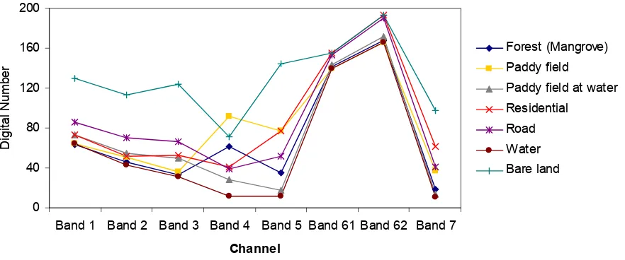
The EBBI is a remote sensing index that applies wavelengths of 0.83 μm, 1.65 μm, and 11.45 μm, (NIR, SWIR, and TIR, respectively) to Landsat ETM+ images. These wavelengths were selected based on the contrast reflection range and absorption in built-up and bare land areas. According to Herold et al. [16], the reflectance values of built-up areas are higher due to the longer sensor wavelengths. The NIR wavelength, which corresponds to band 4 in Landsat ETM+ and band 5 in SWIR, is associated with a high contrast level for detecting built-up and bare land areas, as shown in Figure 2. In addition, in bands 4 and 5, there is an inverse reflectance ratio with respect to detecting built-up or bare land areas compared to vegetation. Vegetation has a high reflectance in band 4, but the reflectance of built-up or bare land in band 4 is low. In contrast, in band 5, there is high reflectance when detecting built-up areas compared with vegetated areas [17]. NIR and SWIR were used for mapping built-up areas in a study conducted by Zha et al. [7] when developing the NDBI.
Zhao and Chen [4] utilised Landsat ETM+ band 5 (SWIR) and band 6 (TIR) to generate the NDBaI. The NDBaI is an index used to map bare land areas. The TIR can distinguish high and low levels of albedo in built-up objects [4]. According to Weng [5], the utilisation of TIR channels is very effective for mapping built-up areas based on a low albedo, which eliminates the effect of shadows and water, while a high albedo demonstrates built-up and bare land areas clearly. The TIR channel also exhibits a high level of contrast for vegetation. The temperature of a built-up area is 10–12 degrees higher than that of vegetation [18]. Therefore, the combination of NIR, MIR, and TIR (Landsat ETM+ bands 4, 5, and 6) wavelengths makes it possible to improve the mapping method for built-up and bare land areas relative to previously existing remote sensing indices.
Remote Sens. 2012, 4 2960
water pixels as well as negative values for vegetation and positive values for built-up and barren pixels. This outcome allows for easy distinguishing between built-up and bare land areas.
Figure 2. Spectral profiles for seven classes of land cover in Denpasar city. Values were derived from an average of 20 pixels for each class of land cover.
0 40 80 120 160 200
Band 1 Band 2 Band 3 Band 4 Band 5 Band 61 Band 62 Band 7
Channel
D
ig
it
a
l
N
u
m
b
e
r
Forest (Mangrove)
Paddy field
Paddy field at water Residential
Road
Water Bare land
To achieve a higher level of contrast, an improvement in the mathematical operations was introduced into the equation used to calculate the EBBI. The EBBI applies a root function to cluster the numbers that contrast identical objects based on the different levels of reflectance values. To obtain an index value of −1~1, the multiplied factor is divided by ten. The EBBI is calculated from the image data using the following formula:
6 Band 5
Band 10
4 Band -5 Band EBBI
+
= (1)
3.2. Data and Analysis
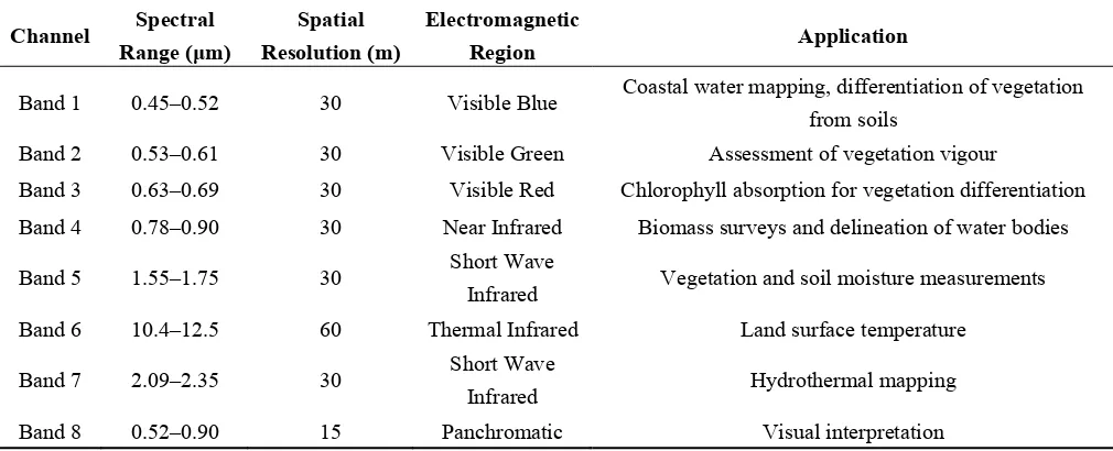
3.2.1. Data
The remote sensing data used in this study were Landsat ETM+ data acquired on 21 May 2002 in Path 116 and Row 66. The spectral wavelength ranges and the spatial resolution bands of the data are presented in Table 1 [19]. The accuracy levels of the analyses performed using several remote sensing indices were compared to the distribution of built-up and bare land areas in the IKONOS imagery analysis. The IKONOS image used for comparison was acquired on 22 April 2002. The interpretation of the distribution of built-up and bare land originated from the Regional Planning and Development Board of Denpasar in 2003. The classification of the IKONOS image had an overall accuracy rate of 96.4%.
3.2.2. Analysis
Remote Sens. 2012, 4 2961
EBBI analysis were compared to the results of remote sensing analyses that used several other indices: the IBI, NDBI, UI, NDBaI and NDVI (Normalised Difference Vegetation Index) [20]. The IBI, NDBI, and UI are indices for quickly mapping built-up areas. In contrast, the NDVI is a well-known spectral index for rapidly mapping the distribution of vegetation and a variety of conditions over land surfaces. Previously, Matthias and Martin [21] applied NDVI for mapping the impervious area of an urban area of Germany. The formulas for the indices that were compared to the EBBI results are as follows:
[
]
where the pixel value used in each channel is the digital number. In this study, the EBBI and NDBal utilised band 6 of the Landsat ETM+ images; band 6 has a 60 m spatial resolution, which was rescaled to 30 m prior to transforming the data into an index.
Table 1. Spectral Bands of Landsat ETM+.
Channel Spectral Range (μm)
Spatial
Resolution (m)
Electromagnetic
Region Application
Band 1 0.45–0.52 30 Visible Blue Coastal water mapping, differentiation of vegetation from soils
Band 2 0.53–0.61 30 Visible Green Assessment of vegetation vigour
Band 3 0.63–0.69 30 Visible Red Chlorophyll absorption for vegetation differentiation
Band 4 0.78–0.90 30 Near Infrared Biomass surveys and delineation of water bodies
Band 5 1.55–1.75 30 Short Wave
Infrared Vegetation and soil moisture measurements
Band 6 10.4–12.5 60 Thermal Infrared Land surface temperature
Band 7 2.09–2.35 30 Short Wave
Infrared Hydrothermal mapping
Band 8 0.52–0.90 15 Panchromatic Visual interpretation
Remote Sens. 2012, 4 2962
Serangan Island. To determine the accuracy of the EBBI, this study examined bare land located in Serangan Island. The validation process was accomplished by comparing the built-up and bare land areas determined by the indices (EBBI, IBI, NDBI, UI, NDBaI and NDVI) with the results from IKONOS. Comparative results were based on the differences in the areal percentage, which were used to determine the level of accuracy.
The percentage of built-up areas was obtained from the IKONOS image analysis. The percentage of built-up area refers to the proportion of built-up area within each pixel. Fifty built-up locations were randomly selected, and polygon sampling of the data was conducted based on the number of Landsat pixels in the image (30 × 30 m). The percentage of built-up areas was correlated to the remote sensing index to determine the relationship between the percentage of built-up areas and the remote sensing indices. The mean bias error (MBE) and the root mean square error (RMSE) [22,23] were used to calculate the systematic and non-systematic errors of each of the transformation indices. MBE is a good measure of model bias and is simply the average of the differences in the set. The RMSE was used to find the average error value between the remote sensing indices and the percentage of built-up areas.
4. Results
The transformation of bands 4, 5, and 6 of Landsat ETM+ was examined in this study. This study investigated the mapping of built-up and bare land areas by EBBI transformation. The EBBI transformation was compared to other transformation indices. The results of the EBBI transformation were compared to the results obtained using IKONOS imagery to determine the levels of accuracy and effectiveness. In addition, the results of comparing the relationship between the EBBI and the percentages of built-up area coverage and remote sensing indices are detailed in this section.
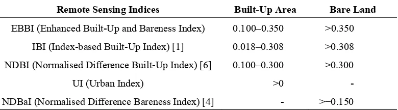
Transforming remote sensing data into an index value required the use of a control index value as a reference index to distinguish the different types of land cover. In this case, the reference was the limit of the index value for each type of transformation index, as shown in Table 2.
Table 2. Limitation of the index value for each type of index transformation in determining non-built-up, built-up, and bare land areas.
Remote Sensing Indices Built-Up Area Bare Land
EBBI (Enhanced Built-Up and Bareness Index) 0.100–0.350 >0.350
IBI (Index-based Built-Up Index) [1] 0.018–0.308 >0.308
NDBI (Normalised Difference Built-Up Index) [6] 0.100–0.300 >0.300
UI (Urban Index) >0 -
NDBaI (Normalised Difference Bareness Index) [4] - >−0.150
4.1. Mapping Built-Up and Bare Land
Remote Sens. 2012, 4 2963
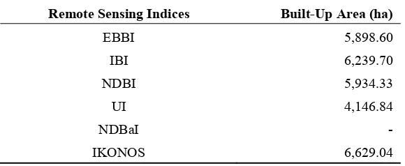
Table 3. The built-up area from each type of index/remote sensing data transformation.
Remote Sensing Indices Built-Up Area (ha)
EBBI 5,898.60
IBI 6,239.70
NDBI 5,934.33
UI 4,146.84
NDBaI -
IKONOS 6,629.04
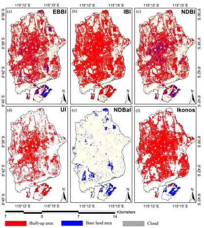
The areas of bare land in Serangan Island determined using the remote sensing indices are presented in Table 4. The area of bare land on Serangan Island as determined by the EBBI is 173.93 ha, which corresponds to 75.11% of the bare land area obtained from IKONOS imagery (231.39 ha). This percentage is higher than the bare land area determined using IBI and NDBI. However, the percentage of bare land indicated by the NDBaI is higher than that determined by EBBI. The overall spatial distribution of built-up and bare land areas obtained from the remote sensing indices and IKONOS data are shown in Figure 3.
Table 4. The bare land area in Serangan Island determined using each type of
index/remote sensing data transformation.
Remote Sensing Indices Bare Land Area (ha)
EBBI 173.79
IBI 105.21
NDBI 100.89
UI -
NDBaI 197.82
IKONOS 231.39
The accuracy levels with respect to the percentage of built-up area for each type of transformation index from IKONOS data are shown in Table 5. The built-up area determined using the EBBI transformation was similar to that determined using the IKONOS data, which was assumed to represent the actual built-up area. A high level of accuracy was demonstrated when the IKONOS results were compared with the NDBI and UI transformations and negligible differences were observed between the IKONOS results and the IBI results. The percentage of similarity between the built-up area determined using the EBBI transformation compared to that from IKONOS was 69.65%; of this value, 25.49% of the IKONOS built-up area was transformed by EBBI into non-built-up area and 4.85% was transformed by EBBI into bare land area.
Remote Sens. 2012, 4 2964
Figure 3. The spatial distribution of built-up areas and bare land is shown for each type of index/remote sensing data transformation: (a) EBBI, (b) IBI, (c) NDBI, (d) UI, (e) NDBaI, and (f) IKONOS imagery.
Table 5. The percent accuracy of the built-up area obtained from each type of index transformation.
Explanation EBBI (%) IBI (%) NDBI (%) UI (%)
Non-built-up area from indices vs.
built-up area from IKONOS 25.49 21.71 25.05 47.11
Built-up area from indices vs.
built-up Area from IKONOS 69.65 70.18 67.60 52.89
Bare land area from indices vs.
built-up Area from IKONOS 4.85 8.11 7.34 –
Total built-up area from indices vs.
Total built-up area from IKONOS 88.98 94.13 89.52 62.56
(a) (b) (c)
Remote Sens. 2012, 4 2965
Table 6. The percent accuracies of the bare land area obtained from each type of index transformation.
Explanation EBBI (%) IBI (%) NDBI (%) NDBaI (%)
Non-bare land area from indices vs. bare land from IKONOS 13.73 12.10 13.15 31.74 Built-up area from indices vs. bare land area from IKONOS 23.45 49.59 50.72 – Bare land area from indices vs. built-up area from IKONOS 62.82 38.31 36.13 68.26 Total bare land area from indices vs. total bare land area from
IKONOS 75.11 45.47 43.60 85.49
When the average accuracy levels of the EBBI, NDBI, and IBI results were compared to those of the built-up and bare land area values obtained from IKONOS, the EBBI was found to exhibit the highest accuracy of all the indices. The EBBI exhibited an average accuracy level of 66.24%, which is higher than those of IBI and NDBI, which had average accuracy rates of 54.25% and 51.87%, respectively. The UI is an index that cannot detect bare land areas, while the NDBaI could not be used because it cannot map built-up areas.
The EBBI can be utilised directly as a highly accurate index for mapping built-up and bare land areas. Although the relative accuracy of the EBBI is lower than that of the IBI for mapping built-up areas and that of the NDBaI for mapping the distribution of bare land areas, the average accuracy level of EBBI represents a substantial improvement in the simultaneous mapping built-up and bare land areas.
4.2. Relationship between the Transformed Remote Sensing Indices and the Percentage of Built-Up Area
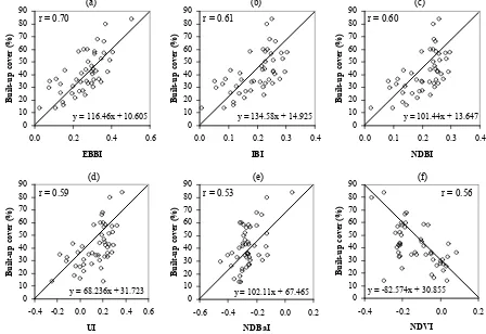
Figure 4 shows the relationship between the percentage of built-up area and the transformation indices (EBBI, IBI, NDBI, UI, NDBaI, and NDVI). The correlation coefficient and linear equation for each of the indices is indicated on the plot. A cross-plot of each index and the percentage of built-up area confirmed the close relationship between the EBBI results with the percentage of actual built-up areas. The relationship between the percentage of built-up areas and the EBBI results shows a high degree of correlation (r = 0.70). This correlation is higher than that of the five other remote sensing indices; the correlation values of the IBI, NDBI, UI, NDBaI, and NDVI are 0.61, 0.60, 0.59, 0.53, and 0.56, respectively.
The scatterplot indicates that the relationship between the EBBI results and the percentage of built-up area is generally higher than those of the other indices. In addition, statistical error analyses also demonstrated that EBBI generally produced lower values than the other indices, except with regard to MBE values, for which NDBaI produced higher values than EBBI. EBBI had an MBE value of 25.37%, while the MBE values of the IBI, NDBI, UI, NDBaI and NDVI were 60.03, 71.66, 57.84,
Remote Sens. 2012, 4 2966
Figure 4. Scatterplots of the built-up area percentage vs. the remote sensing transformation indices. (a) EBBI, (b) IBI, (c) NDBI, (d) UI, (e) NDBaI, and (f) Normalised Difference Vegetation Index (NDVI) .
Figure 5. Mean bias error (MBE) and root mean square error (RMSE) statistical values
between the percentage of built-up area and the remote sensing transformation indices.
-20
EBBI IBI NDBI UI NDBaI NDVI
Remote sensing indices
Urban remote sensing indices are generally used to distinguish built-up and bare land areas based on spectral values with a low level of accuracy because of the high degree of homogeneity in these land-use categories, especially in urban areas. However, utilisation of the EBBI, which is the first built-up and bare land index based on thermal infrared data, can increase the accuracy of mapping built-up and bare
Remote Sens. 2012, 4 2967
land areas. The EBBI was also found to be very effective in distinguishing built-up and bare land areas, which is one of the major limitations of applying built-up area indices based on remotely sensed data. The use of three infrared channels (NIR, SWIR, and TIR) that reflect different contrasts in detecting built-up, bare land, and vegetation areas is responsible for the high accuracy level compared to other built-up area indices.
The application of TIR channels, which exhibit high emissivity in built-up areas, is one of the reasons that EBBI is a better index for distinguishing between classes of land use. The high emissivity in built-up areas is caused by the types of materials that are predominately found in these areas, such as roofing and building materials. In contrast, the emissivity of bare soil is determined by the level of soil moisture and by the mineral constituents of the soil [24]. Built-up areas exhibit higher heat conductivity than bare soil areas, resulting in the higher emissivity and albedo values of thermal infrared waves in built-up areas relative to bare soil areas.
The EBBI not only exhibits a better accuracy than other indices, but also was able to distinguish the amount of built-up areas with a higher correlation than other indices used in urban areas. The EBBI generally produced lower statistical errors regarding the measurement the built-up area percentage. The correlation levels between the percentage of built-up areas and the results of the other indices were all positive, with the exception of the results of NDVI. In addition, the MBE and RMSE values were generally lower than those determined by the other indices, with the exception of the MBE values, for which the value produced by NDBaI was better than that produced by EBBI. The utilisation of TIR channels and the improvement of the mathematical operations in the applied root function enhanced the statistical score regarding the percentage of built-up areas determined by the indices. TIR was also able to capture the temperature radiation released by buildings. Areas with relatively high building densities will emit larger amounts of temperature radiation. The root function applied in the EBBI contrasted identical objects based on different levels of reflectance values. The negative correlation exhibited by the NDVI was observed because this index is usually applied to rapidly map the distribution of vegetation. In NDVI, a smaller value indicates less vegetation, which results in a negative correlation with the amount of built-up areas. The relationships observed between the remote sensing indices and the amount of built-up area were similar to the results of previous studies, such as those of Widyasamratri [25] and Sukristiyanti et al. [11], who found the correlation coefficient between the UI-built-up area density in Semarang city to be 0.56 and 0.59, respectively.
The high degree of land homogeneity in built-up and bare land areas resulted in a low level of accuracy. Some regions in built-up areas were detected as non-built-up or bare land areas or were observed as noise in EBBI and NDBI images (Figure 3(a,c)). The spectral response of built-up areas showed a higher reflectance in the SWIR compared with the NIR wavelength range. However, in urban areas with heterogeneous landscapes, this factor is not always relevant. Drier vegetation or areas with mixed vegetation and buildings in a particular pixel can exhibit an even higher reflectance in the SWIR wavelength range than in the NIR range [26], thus leading to confusion with areas of built-up land. According to Yüksel et al. [27], accurate map processing in urban landscapes is further complicated by surface heterogeneity. Improving the spatial resolution may improve the accuracy of remote sensing in capturing small-scale objects over heterogeneous surfaces in urban areas [28].
Remote Sens. 2012, 4 2968
fluctuations in the centre of the town are substantial and may cover many different land use types. This creates a problem for subdividing urban areas into generalised classes of urban land uses and activities based on the spectral values of each individual pixel. Therefore, the accuracy of such techniques may decrease in regions with highly heterogeneous landscapes [29].
All the indices could not perfectly differentiate between built-up and bare land because both of these land types show similar spectral responses in all Landsat ETM+ bands. However, the EBBI was found to be superior to the other indices in distinguishing between built-up and bare land due to the use of TIR channels. Visual inspection of the extraction results showed that confusion mainly occurs between built-up areas and bare land areas. Mixed regions were detected by the EBBI as built-up in bare land areas in regions with a highly heterogeneous landscape, which exhibit high values in NIR and SWIR because of the drier vegetation. Generally, all of the findings of this study demonstrated that the EBBI could be utilised as an alternative and more accurate remote sensing index to distinguish built-up areas from other land use areas and determine the cover percentage of built-up areas.
Data from built-up areas are very important for determining correlations between land use and environmental conditions, such as air and water quality and water runoff. It expected that in the future, the EBBI could be used in various applications associated with the utilisation of remote sensing data, specifically in the field of urban remote sensing. There are a number of potential applications for the EBBI, such as monitoring land use changes, following the development of cities, determining the condition of the urban environment, and calculating the urban population.
6. Conclusions
In this study, a new index for transforming remote sensing data was proposed and evaluated for mapping built-up and bare land areas. The index was able to map built-up and bare land areas with a single calculation and was referred to as the Enhanced Built-up and Bareness Index (EBBI). The EBBI is the first built-up and bare land index that uses the NIR, SWIR, and TIR channels simultaneously. The EBBI was applied in Denpasar, Indonesia, to distinguish between built-up and bare land in an urban area, and the results obtained by the EBBI were compared with those determined by other available remote sensing indices.
The use of the EBBI was found to improve the accuracy of mapping built-up and bare land areas. The EBBI was also effective at discriminating between built-up and bare land areas in an urban area. With regard to distinguishing between built-up and bare land areas with a single calculation, the EBBI showed an average accuracy level of 66.24%, which is higher than those of the IBI and NDBI (54.25% and 51.87%, respectively). The advantage of the EBBI is that it can be used not only to map built-up and bare land areas but is also capable of transforming the percentages of built-up land in urban area. Comparisons of the relationships between the percentages of built-up obtained from the EBBI and the five other remote sensing indices showed that the EBBI determines the built-up density percentage with higher accuracy (0.70) than the other indices.