Adaptive Capacity for Resilient Coastal
Communities: Climate Change and
This publication is available electronically on the Coastal Resources Center’s website at http://www.crc.uri.edu
For more information on the Integrated Coastal and Fisheries Governance project, contact: Coastal Resources Center, University of Rhode Island, Narragansett Bay Campus, 220 South Ferry Road, Narragansett, Rhode Island 02882, USA. Brian Crawford, Director International Programs at [email protected]; Tel: 401-874-6224; Fax: 401-874-6920.
Friends of the Nation: http://www.fonghana.org
Hen Mpoano: http://www.henmpoano.org
Citation: Kankam, S., Robadue, D., Stevens, H., Inkoom, J., Adupong, R., Fenn, M. (2013) Adaptive Capacity for Resilient Coastal Communities: Climate Change and Natural Hazards Issues in Coastal Districts of Ghana’s Western Region. Coastal Resources Center, University of Rhode Island. USAID Integrated Coastal and Fisheries Governance Program for the Western Region of Ghana. 73 pp.
Disclaimer: This publication is made possible by the generous support of the American people through the United States Agency for International Development (USAID/Ghana). The contents of this report are the responsibility of the Integrated Coastal and Fisheries Governance (ICFG) Program and do not necessarily reflect the views of the United States Government. Associate Cooperative Agreement No. 641-A-00-09-00036-00 for “Integrated Coastal and Fisheries Governance (ICFG) Program for the Western Region of Ghana,” under the Leader with Associates Award No. EPP-A-00-04-00014-00.
Acknowledgements
This assessment was made possible through diverse contributions from many individuals including personnel of the district assemblies and representatives of the coastal communities which were the focus of the assessment. We appreciate the coordinating role played by Justice Inkoom in support of the Ahanta West field team and the participation of Anita Boateng Ameyaw, Fred Krah, Hibba Abaidoo, Patricia Aba Mensah, Nathan Asamoah and Theophilus Boachie-Yiadom in the district’s data collection exercises. The supervisory role of Kyei Kwadwo Yamoah for the Nzema East team is also acknowledged as well as the participation of Frederick Eduful, Nana Efua Ewur, Felix Nani, Abigail Mensah, Kwabena Aseidu-Bediako, Agatha Mensah and Charles Ebeleku in the district’s data collection exercises. We also express our sincere gratitude to Balertey Gormey and Kwesi Johnson for coordinating the Ellembelle District field team and to the team which comprised John Blay, Jacinta Erzuah, Patrick Takyi, Keti Doe Lawson, George Yeboah, Miah Blay, Maxwell Essien and Reverend Donkor for dedicating time to the data collection exercises. The coordinating role played by Richard Adupong for the Jomoro District team and the data collection exercises conducted by the team which comprised George Somiah, Jemima Adorsu, William Adongo, Abdallah Sualih, John Ekobo and Ebenezer Ackah are acknowledged.
Our gratitude also goes to Dr. Donald Robadue and Hilary Stevens for developing the initial instruments for field data collection and to Mark Fenn and Stephen Kankam for revising and adapting the instruments to suit the local context. Our last and strongest acknowledgement go to the people of the coastal communities – youth, parents, men, women, fishermen,
Table of Contents
Acknowledgements ... ii
Table of Contents ... iii
List of Figures ... iv
List of Tables ... iv
PART I: OVERVIEW AND SUMMARY OF CLIMATE THREATS AND ADAPTIVE CAPACITY IN WESTERN REGION’S COAST ... 1
1.1 Current and Expected Climate Changes ... 3
1.2 Climate Change Vulnerability and Adaptive Capacity ... 8
1.3 Way Forward in the Western Region: Approaches for Improving Climate Change Adaptation ... 12
Orientations for future planning and vulnerability assessment for coastal districts ... 15
Part II: RAPID ADAPTIVE CAPACITY ASSESSMENT FOR CLIMATE CHANGE AND NATURAL HAZARDS IN FOUR COASTAL DISTRICTS OF THE WESTERN REGION ... 17
Introduction ... 17
2.1 Jomoro District Summary ... 17
2.2 Ellembelle District Summary ... 27
2.3 Nzema East District Summary ... 37
2.4 Ahanta West District Summary ... 46
REFERENCES ... 54
Appendix A Assessment Instrument: Rapid Assessment of Vulnerability and Resilience in Coastal Communities of the Western Region ... 55
Background Information on the Assessment ... 55
Theme 1: Governance and Leadership (GL) ... 56
Theme 2: Coastal Resource Management (CRM) ... 60
Theme 3: Risk Awareness and Emergency Response (RA) ... 62
Theme 4: Economy and Society (ES) ... 66
List of Figures
Figure 1 An aerial view of hazards and stresses faced by Akwidaa ... 6
Figure 2 Number of communities with a given count of climate related coastal hazards ... 7
Figure 3 Rank order of communities with a given level of climate related coastal hazards ... 8
Figure 4 Distribution of adaptive capacity scores in 77 coastal settlements, in rank order ... 10
Figure 5 The distribution of adaptive capacity scores in 77 coastal settlements, in rank order by District... 11
Figure 6 Community level adaptive capacity and exposure to hazards, Jomoro District ... 19
Figure 7 Number of hazards and stresses in Jomoro's coastal settlements ... 20
Figure 8 Example of exposure analysis for Jomoro coastal settlements ... 21
Figure 9 Jomoro Community Adaptive Capacity Scores ... 24
Figure 10 Community Level adaptive capacity and exposure to hazards, Ellembelle District28 Figure 11 Number of hazards and stresses in Ellembelle’s coastal settlements ... 29
Figure 12 Severe flooding in a coastal settlement in Ellembelle attests to the high level of exposure to hazards ... 30
Figure 13 Ellembelle’s Community Adaptive Capacity Scores ... 34
Figure 14 Community Level adaptive capacity and exposure to hazards, Nzema East Municipal Assembly ... 38
Figure 15 Number of different hazards and stresses in coastal settlements Nzema East District ... 39
Figure 16 Damage to coastal infrastructure in a coastal settlement in Nzema East indicates ongoing problems from erosion and flooding ... 40
Figure 17 Nzema East Community Adaptive Capacity Scores ... 43
Figure 18 Community Level adaptive capacity and exposure to hazards, Ellembelle District46 Figure 19 Number of different hazards and stresses in coastal settlements, Ahanta West District... 47
Figure 20 Incomplete and damaged harbor defense system in Ahanta West is evidence of past attempts to protect the harbor and ongoing damage from high wave energy ... 48
Figure 21 Ahanta West Community Adaptive Capacity Scores ... 51
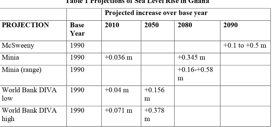
List of Tables Table 1 Projections of Sea Level Rise in Ghana... 4
Table 2 Average adaptive capacity scores in the coastal settlements in four Western Region districts ... 9
Table 3 Adjusted Rank order of community resilience (fraction of total possible score on the 8 adaptive capacity areas) in Jomoro District ... 18
Table 4 Summary of community level adaptive capacity across eight variables and Jomoro improvement actions ... 25
Table 5 Adjusted Rank order of community resilience (fraction of total possible score on the 8 adaptive capacity areas) Ellembelle District ... 31
Table 6 Summary of community level adaptive capacity across eight variables and Ellembelle improvement actions ... 35
Table 7 Adjusted rank order of community resilience (fraction of total possible score on the 8 adaptive capacity areas) Nzema East District ... 41
Table 8 Summary of community level adaptive capacity across eight variables and Nzema East improvement actions ... 44
Adaptive Capacity for Resilient Coastal Communities: Climate
Change and Natural Hazards Issues in Coastal Districts of
Ghana’s Western Region
PART I: OVERVIEW AND SUMMARY OF CLIMATE THREATS AND ADAPTIVE CAPACITY IN WESTERN REGION’S COAST
Recently available climate change scenarios for Ghana show a compounding of the impacts of existing hazards on coastal districts and communities in the Western Region. Moderate sea level rise is accelerating shoreline erosion, increasing coastal flooding, threatening the
functioning of piers, docks and seawalls, shifting estuaries to ocean salinity levels,
contaminating coastal fresh water wells, and intruding on coastal river water supply intakes. Changes in air and water temperature, change in rainfall intensity and frequency, and the patterns of rainfall and storm runoff are also affecting public safety, economic well-being and food availability. Increased pressure on marine fisheries since the 1970s, is placing the resources under greater strain, and making the entire supply chain, which involves thousands of fishers in dozens of coastal fish landing sites in the Western Region, increasingly
vulnerable. According to recent research in the upwelling area, “changes in sea temperature could affect primary (phytoplankton) and secondary (zooplankton) production which in turn could dramatically increase or decrease the abundance of pelagic fishes and their predators” (Stanturf et al., 2011). Coastal settlements and landscapes in the region also face multiple natural hazards that are being influenced and worsened by climate change either through sea level rise or flooding.
Given the foregoing impacts, Ghana has already begun to educate and raise the level of public discussion through the formulation of a national strategy and the Ministry of Environment, Science and Technology’s Policy Advice series on climate change and adaptation. Ghana still needs better, downscaled scenarios for hazards and climate change planning to help it examine full range of impacts on places and sectors. Better science funding is needed for monitoring trends.
In 2011 and 2012, Hen Mpoano assessed 77 Western Region coastal communities in the Districts of Jomoro, Ellembelle, Nzema East and Ahanta West to gain an understanding of their concerns and capacity. The findings indicated that adaptive capacity is limited in coastal communities. Some locations are faring better than others, but overall, coastal communities have weak ability to respond to emergencies generated by natural hazards, they suffer social and economic development challenges that are worsening, and they have a relatively low ability to manage coastal resources in a way that will ensure sustained productivity and environmental quality.
funding and technical assistance are prioritized to support the most vulnerable sectors, social groups and ecosystems. For instance, policies can be adopted to enhance the management of coastal resources and build resilient local economies against climate impacts. Districts can also formulate regulations that recognize dynamic and ecologically sensitive coastal and shoreline features and incorporate restrictions for construction in shoreline areas. Such regulations can control development and encourage a strategic retreat from low-lying coastal floodplains and high hazard areas within the vicinity of shorelines. Districts can prepare local plans for selected communities to generate additional understanding and appropriate
responses to the physical impacts of erosion, flooding and physical hazards which will be increased due to climate change impacts. This should include using low cost, low technology and participatory methodologies to undertake community-based vulnerability assessments and develop adaptation strategies.
Certain policies to address climate impacts and coastal hazards are more effective when adopted and applied through regional mechanisms. For instance, all of the coastal districts might want to use the same policy, such as riparian and floodplain buffer policies that would also be incorporated into the regional development framework as well as district structure plans. This would discourage investors from ‘shopping around’ to find a more lenient district. Flood plain mapping and general setbacks from high hazard areas are needed for each
district. This should also follow a common approach across the region to make rules and local decisions more predictable, acceptable and responsive to climate impacts. In addition, the current Environmental Impact Assessment (EIA) review process which involves case by case decisions on facilities of regional significance need to take into account an understanding of the larger system, as well as impacts beyond the boundaries of a particular project.
PART I CLIMATE CHANGE IMPACTS, VULNERABILITY AND ADAPTIVE CAPACITY
IN GHANA’S COASTAL ZONE
1.1 Current and Expected Climate Changes
Climate change vulnerability in coastal communities varies from place to place. Coastal areas and settlements exposed to the climate impacts threatening Ghana are sensitive to them in differing degrees, for example some settlements are built in dangerous low-lying areas while others are setback from eroding shorelines and flood-prone wetlands. In addition, each community has a different ability to adapt to the stresses it faces from climate and non-climate stresses on its well-being.
Since the 1990s a number of studies and plans have been prepared for Ghana to help it understand climate impacts including air and sea temperature changes, sea level rise,
precipitation amount, seasonal distribution and storm frequency and intensity. These include the Netherlands Climate Assistance Programme (Agyemang-Bonsu, W. K.,2008), the World Bank’s Economics of Adaptation to Climate Change (2010), USAID’s recent Ghana Climate Change Vulnerability And Adaptation Assessment (Stanturf, 2011), Ghana’s National
Climate Change Adaptation Strategy (2010) and the ongoing Policy Advice series on climate change by Ghana’s Ministry of Environment, Science and Technology (Environmental Protection Agency, 2012). All of these reports acknowledge the uncertainty associated with projections of temperature, rainfall patterns, storm frequency and intensity and sea level rise, trying to clarify and address the climate impacts that will affect coastal districts in the
absence of detailed agreed-upon scenarios for the different regions of Ghana.
A helpful recent summary and explanation of climate scenarios for Ghana has been prepared by Stanturf et al. (2011). In the simplest terms, mean annual temperature is expected to increase 1.0 to 3.0 C by the 2060s, with differences among regions of Ghana. For the coastal savannah zone, “wet season temperatures would range from 1.68 ± 0.38°C by 2050 and 2.54 ± 0.75°C by 2080; dry season, 1.74 ± 0.60°C by 2050 and 2.71 ± 0.91°C by 2080 during the dry season.” Sea surface temperatures are also expected to increase. A report from EPA-NCAP projects “sea-surface temperatures to rise from the annual base mean of 26.2 to median model estimates of 26.6, 27.6, and 28.9°C for the years 2020, 2050, and 2080. Upper boundary estimates were 26.8, 28.1, and 30.0°C for the respective 30-year periods.”
Consistent projections of precipitation amounts and patterns in the different regions of Ghana have unfortunately remained elusive. Stanturf et al. point out that “forecasted changes in precipitation ranged from 52 percent decreases to 44 percent increases in wet season rainfall by 2080. The overall ensemble prediction across emission scenarios gives a slight increase in wet season rainfall of 2.65 ± 13.96 percent by 2050 and 3.88 ± 19.41 percent by 2080. The variability among the models' precipitation changes is not very different from the inter-annual variability currently experienced in the region.”
Sea Level Rise effects on the shore and built coast
Sea level rise in the Western Region can have a number of impacts, accelerating erosion, coastal flooding, threatening the functioning of piers, docks and seawalls, shifting estuaries to ocean salinity levels, contaminating coastal fresh water wells, and intruding on coastal river water supply intakes. Working with global data and best-available local estimates,
0.1-0.5 meters by 2090, relative to 1990 levels. Minia (2008) projects a similar result, estimating an 0.036 m increase between 1990 and 2010, and 0.345 m by 2080 (the increase could be as low as 0.16 m higher or as high as 0.58 m by 2080, given the variation in climate forecasts). Recent low and high scenarios by the World Bank fall also within these ranges.
Table 1 Projections of Sea Level Rise in Ghana Projected increase over base year PROJECTION Base
Year 2010 2050 2080 2090
McSweeny 1990 +0.1 to +0.5 m
Minia 1990 +0.036 m +0.345 m
Minia (range) 1990 +0.16-+0.58
m World Bank DIVA
low 1990 +0.04 m +0.156 m
World Bank DIVA
high 1990 +0.071 m +0.378 m
The World Bank estimated that 170 km2 of the Western Region coast (defined as the area up to 30m in elevation) will be exposed to sea level rise impacts, affecting an existing population of 16,830. Hen Mpoano’s assessment of 77 Western Region coastal communities in Jomoro, Ellembelle, Nzema East and Ahanta West indicates that these communities already face from 1 to 9 significant physical hazards, most of which will be intensified by sea level and other climate related changes. Infrastructure threatened by sea level rise includes ports, oil and gas infrastructure, salt production facilities and countless village-scale fish landing and
processing sites. (Armah, 2005)
Recent assessments of the situation for Ghana coast-wide look at the benefits and costs of adaptation measures to fight erosion and protect coastal infrastructure using an extensive system of seawalls, dikes as well as replenishing sand lost on highly eroding beaches. The World Bank concluded that the annual costs of such a program, ranging from $47 to $155 million per year, far outweighed the value of damage that would be avoided. A more balanced approach for the Western Region involves applying sound coastal management principles and is described here as well as in the Shoreline Management Issue Brief as part of this series.
Salt water intrusion from sea level rise
Many coastal communities are reporting that their wells are being contaminated by salt water. This problem can result from the intrusion of salt water as a result of coastal erosion as well as overdrawing the wells. The situation is worsened by longer dry seasons when less freshwater replenishes the fresh groundwater supply. Population growth and expansion of industries that rely on freshwater increase the demand on the water supply and exacerbate this problem. The water supply issues facing the Western Region coastal districts are discussed in more depth in Hen Mpoano’s Freshwater Supply Issue Brief.
Coastal fisheries
Marine fisheries depend to a large extent upon the Central West African Upwelling, which has a seasonality tied to atmospheric and ocean circulation, making its productivity variable and difficult to predict but favoring small pelagic species. However, marine fishing has increased dramatically since the 1970s, placing the resources under greater strain, and making the entire supply chain, which involves thousands of fishers in dozens of coastal fish landing sites in the Western Region, increasingly vulnerable. Nearshore pressures on fish habitat include water pollution, and nursery area destruction. Coastal and lagoon habitats, also affected by sea surface temperature, play a smaller but important role in providing income and protein. According to recent research in the upwelling area “Changes in sea temperature could affect primary (phytoplankton) and secondary (zooplankton) production which in turn could dramatically increase or decrease the abundance of pelagic fishes and their predators” (Stanturf et al., 2011)
Coastal landscapes and livelihoods
Climate impacts on agriculture and the landscapes of the coastal districts of the Western Region are expected to change in the next decades as a result of temperature and precipitation in addition to other factors that are fragmenting the mosaic of land cover. For example, cocoa is expected to largely disappear as a cash crop in the coastal districts (Läderach, 2011). According to Stanturf et al. (p. 74) “Cocoa is highly susceptible to drought and the pattern of cropping of cocoa is related to rainfall distribution. Climate change could affect vigor of the cocoa plant as well as alter stages and rates of development of cocoa pests and pathogens”.
Coastal settlements
The coastal communities of the Western Region face multiple natural hazards that all will be influenced and made worse by climate change either through sea level rise or flooding. An assessment by the Hen Mpoano initiative of 77 communities in the districts of Jomoro, Ellembelle, Nzema East and Ahanta West identified nine different types of hazards of local concern:
• presence or proximity to a river source, • proximity to an estuary,
• high water mark visible in settlement,
• presence and or functionality of sea defense walls, • condition of coastal bridge,
• flood risks, • coastal erosion,
• community backed by a wetland and
• presence of dynamic coastal features along the beach
face 5 different hazards. The district of Shama, not part of this assessment, with its much more heavily developed shoreline, has examples of all 9 issues, made clear during the past two years when it conducted an extensive analysis of its coastal hazard and climate change issues. Shama is already beginning to develop climate adaptation and hazard mitigation policies as part of its spatial development framework. Issue briefs prepared on coastal erosion and wetlands in the Western Region (Coastal Hazards and Flooding Risk in Ghana’s Western Region) have more information on how Western Region communities are affected by natural and human-caused impacts on the shoreline and wetland ecosystems.
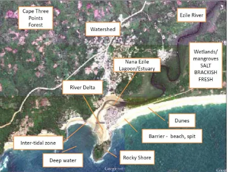
An example of one of the most stressed locations is the fishing community of Akwidaa, along the Cape 3 Points coast in Ahanta West. It is located on a low-lying sand spit at the mouth of the Nyan River, which drains a large sub-basin including the district capital Agona. The settlement is covered with flood waters from upstream river flow during rainy periods, its beach facing and estuary facing shores are being steadily eroded. The access road is periodically over-washed and the footings of the heavily traveled pedestrian bridge are constantly undermined. Its adaptive capacity score (explained in the next section) is among the lowest coast-wide, making it especially vulnerable to impacts of climate change.
Figure 2 Number of communities with a given count of climate related coastal hazards
0 3
11 16
22
17
5
3
0 0 0
5 10 15 20 25
0 1 2 3 4 5 6 7 8 9 More
N
u
m
b
e
r
o
f
co
m
m
u
n
it
ie
s
Number of coastal hazards
Figure 3 Rank order of communities with a given level of climate related coastal hazards
1.2 Climate Change Vulnerability and Adaptive Capacity
The climate change vulnerability of a community is comprised of four main elements: • the climate impacts it is exposed to.
• the non-climate physical stresses facing the community.
• the sensitivity of the physical, social and economic systems in the location to those impacts.
• the adaptive capacity of the environment and especially the people to deal with those impacts it is sensitive to.
There is no exact mathematical formula that would allow us combine the available information on all these factors to produce individual community vulnerability score.
However, Hen Mpoano’s assessment and work with coastal communities has generated some important insights that allows for assessment of the various factors of vulnerability and
Akwidaa
Number of hazards and stresses in coastal communities, by District
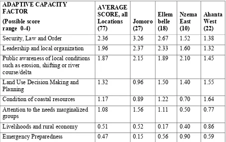
Hen Mpoano’s assessment of 77 communities assessed 8 dimensions of adaptive capacity. As the table indicates, the communities overall scored themselves highest in questions of
security, law and order, and weakest in emergency preparedness, livelihoods, managing their coastal resources and ability to attend to the needs of marginalized groups.
Community Capacity to Adapt to Natural Hazards and Climate Change is generally low
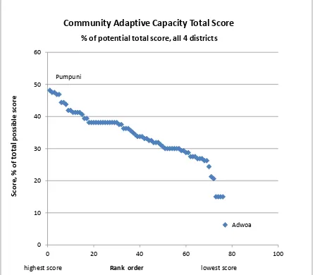
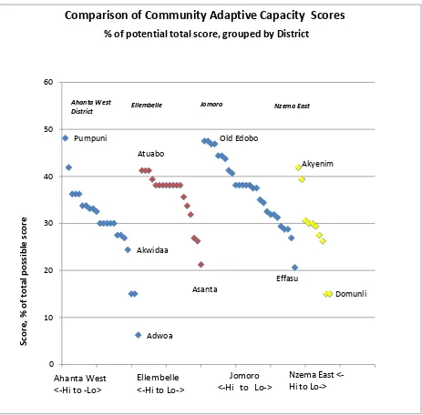
Overall, Western Region coastal communities have disappointingly limited adaptive capacity. A few locations are faring better than others within their District for some dimensions of adaptive capacity, for example Pumpuni in Ahanta West, Atuabo in Ellembelle, Old Edobo in Jomoro and Akyenim in Nzema East. But overall, coastal communities have a low ability to respond to emergencies generated by natural hazards, suffer social and economic
development challenges that will only be worsened, and have a relatively low ability to manage coastal areas and resources in a way that will assure sustained productivity and environmental quality.
Table 2 Average adaptive capacity scores in the coastal settlements in four Western Region districts
Leadership and local organization 1.96 2.37 2.33 1.60 1.32 Public awareness of local conditions
such as erosion, shifting or river course/delta
1.87 2.15 1.89 2.10 1.45
Land Use Decision Making and
Planning 1.32 0.96 1.50 1.40 1.55
Condition of coastal resources 1.17 0.89 1.22 0.70 1.64
Attention to the needs marginalized
groups 1.08 1.56 1.11 0.50 0.77
Livelihoods and rural economy 0.51 0.52 0.17 0.40 0.86
Emergency Preparedness 0.47 0.15 0.56 0.90 0.59
The communities in the westernmost district of Jomoro, for example, have above average leadership, with fairly few communities having either notably strong or weak governance structures in place. While nearly all of those communities have a relatively good situation in terms of law and order, very few have any emergency preparedness systems in place. The economic data from Jomoro indicates that nearly all communities face declining incomes and constricting employment opportunities. The heavy dependence on fishing and farming, both of which are natural resource-dependent and therefore susceptible to climate change,
Figure 4 Distribution of adaptive capacity scores in 77 coastal settlements, in rank order
Pumpuni
Adwoa
0 10 20 30 40 50 60
0 20 40 60 80 100
Community Adaptive Capacity Total Score
% of potential total score, all 4 districts
S
co
re
,
%
o
f
to
ta
l
p
o
ss
ib
le
s
co
re
Pumpuni
Comparison of Community Adaptive Capacity Scores
% of potential total score, grouped by District
Ellembelle Jomoro Nzema East
S
The adaptive capacity assessment found that the number of hazards facing a community and its level of adaptive capacity are not correlated. In essence every coastal community in the region faces a unique combination of circumstances in terms of potential for impact and ability to cope. It is clear that for some factors, including emergency preparedness,
livelihoods/ economy and the situation of marginalized groups, districts across the board are in bad shape and need to take actions that will benefit all the coastal settlements. For others, such as public security, quality of leadership, and public awareness, the situation differs place to place.
1.3 Way Forward in the Western Region: Approaches for Improving Climate Change
Adaptation
Coastal climate change adaptation strategy for the Western Region
The scale and scope of climate change impacts on coastal districts and communities in Ghana’s Western Region are becoming increasingly clear, and they cut across many of the social, economic and environmental concerns of residents and businesses. It is important to get ahead of natural hazard and climate problems to make good choices before developments are built in hazardous areas using unwise construction practices. It is essential to see the workings of the shore, watershed systems whole, improve the quality of information on existing situation, and using scenarios to highlight likely future hazards and risks. Important international donors interested in climate change adaptation such as the World Bank have already made it clear in Ghana that large scale engineering solutions such as networks of dikes and sea defenses or beach sand replenishment are simply not cost-effective. Districts need to rely more on identifying and retreating from high hazard zones, and
accommodating settlements and projects to likely future conditions through safer construction practices and keeping natural buffers such as dunes, mangroves and coastal vegetation intact. Protection and shore defenses should be utilized only when necessary: Retrofitting “hard” solutions such as sea walls and rock riprap is very expensive and may not produce lasting protection.
It is time to help coastal communities already at risk address both physical development issues as well as social and economic problems that will prevent them from coping successfully with climate change and other stresses. Resilience and increased adaptive capacity is the goal, looking out for most vulnerable groups; support economic and social development goals in addition to emergency response and public safety since adaptive capacity is reduced by economic stress, over reliance on a single, resource dependent
livelihood, and weak education and training. For example, a number of coastal communities in the Western Region have the potential to shift from over-reliance on marine fisheries to including small to medium scale tourism. Investing in infrastructure, training and tourism facilities should take into account the physical risks to those investments, the impacts of poor development choices on the quality of the environment and tourism attractions, the ability of the communities to participate in and obtain material and social benefits from new
development.
Priorities for improving climate change adaptive capacity
Emergency Preparedness
The Western Region’s coastal communities are uniformly in very poor shape in terms of their ability to learn about, organize and effectively respond to emergencies and disasters, which is a fundamental ability that would pay big dividends in improving local resilience. Districts need to work with NADMO and other authorities to put together a comprehensive approach at the local level which would include:
• Communications • Local organization
• Education and awareness • Training
• Equipment • Supplies
Livelihoods and rural economy
This dimension of adaptive capacity is equally low in most coastal communities, and a far greater challenge, and somewhat hard to understand given that a number of economic sectors in coastal districts, such as oil & gas, mining, agro-industry and urban development are booming.
• Incorporate climate and hazards elements into economic development programs. • Assess economic sector and infrastructure vulnerability.
• Increase attention to addressing the natural hazard and economic issues in fish landing sites.
• Early actions to increase economic resilience in livelihoods to improve traditional livelihoods as well as pursue promising areas such as small to medium scale tourism.
Attention to the needs of marginalized groups -
Coastal communities rated themselves low in terms of their ability to deal with the needs of elderly, sick, disabled and extremely poor people. This is an important concern during emergencies as well as the longer term issue of resettlement and even relocation where it is needed. Since marginalized groups are more likely to be living in hazardous locations, they are the least able to accommodate their living situations to deal with worsening physical hazards, and will most feel the impacts as the overall resilience of their community diminishes.
• Prepare and implement effective early warning messages that reach marginalized groups.
• Identify and support women’s contribution to informal early warning systems. • Develop and implement evacuation and recovery plans that meet the needs of
children, elderly and the sick.
• Early actions to increase economic resilience of poor people through diversified livelihood opportunities, especially for women, elderly people, people with
disabilities, ethnic minorities, people living with HIV/AIDS and tenant farmers.
Condition of coastal resources
Many coastal communities see that their once abundant coastal resources that could be relied upon for food and income are in a substantially degraded state. This series of issue briefs is focused on improving the quality of coastal resources management in districts and
• Communities need to adopt policies that recognize coastal features and discourage construction in hazardous zones.
• Communities must be engaged in setting priority uses matched to sensitivity of coastal areas in their local plans, backed up by the District spatial development framework and mid-term development plans.
• Assess effectiveness of existing shore defenses.
• Identify areas where setbacks, retreat, restoration and protection are preferred. • Incorporate refugia, which are protected areas where wetlands, flood plains and
landscape habitats can move to in response to sea level rise and climate change.
Land Use Decision Making and Planning
The coastal districts in the Western Region are just now, in 2012, beginning to put into place the tiered set of land use and development plans. Up to now, communities themselves have had relatively little role in setting out land use policies except by the decisions made to allocate stool lands and individual behavior in deciding where to build businesses, houses and community facilities. Fortunately national guidelines now require districts to look at natural hazards and climate change impacts as part of their development planning.
• Conduct cross-cutting vulnerability assessment for coastal region as part of 2014 Mid-Term Development Plans.
• Set priorities for coastal development based on dependence of water location and allocate suitable lands for relocation of infrastructure and settlements.
• Designate flood-prone areas and set limits on allowable uses.
• Improve the flood and climate resilience of existing & new housing and business structures in terms of construction and placement.
• Minimize development or investments requiring shore, river bank or other major flood control.
• Conduct engineering studies of settlement and river drainage systems to remediate recurrent problems, flood plain management and retention areas.
• Introduce low-impact settlement planning, transportation system approaches. • Carefully planned and implemented resettlement, requires identification of a safer
area that meets the needs of residents, including proximity to the fish landing site, agricultural lands, and existing infrastructure such as transportation corridors and water supply facilities.
Public awareness of local conditions such as erosion, shifting or river course/delta
Many community members are able to recall and discuss the physical changes occurring in their settlements. There has been relatively little effort to bring together and convey the bits of scientific research and characterization of hazards and climate change to the community level. Part of the challenge is the complex path from global computer models used to estimate impacts and absence of specific local information. Better regional forecasts and insight are needed. Additional steps involve:
• District wide awareness and education coupled with settlement or ecosystem specific vulnerability assessments and adaptation plans.
• Training for engineers, architects, planners and contractors on hazardous sites and best planning, design and construction practices.
Leadership and local organization
The credibility of a community’s leadership, degree to which decision-making is
participatory, effectiveness of local government functionaries, presence and functionality of community organizations, have far reaching implications for the conditions that give rise to vulnerability and adaptive capacity. The following actions will enhance the process of building local leadership and strengthening community organization:
• Develop community cohesion.
• Create dialogue platforms to facilitate engagement between community folks and their leaders on issues of common interest.
• Create a transparent process for decision making on disposal of communal lands and other community assets.
• Build leadership skills among the youth in preparation for future roles.
Security, Law and Order
The coastal settlements are relatively peaceful with no major incidents of arson, attacks, thefts and conflicts recorded in the past decades. This is indicative of peace and stability in most of the coastal communities. Overall, people feel safe to live in their communities and comply with laws and norms. It is crucial to maintain this relative peace and stability in the coastal communities, especially at a time of influx of migrants into the region to participate in the new oil economy.
• Support peace campaigns and other programs that build upon the relative peace in coastal communities.
• Develop and implement programs to build trust, improve communications and relationships between oil and gas companies and frontline communities.
• Create dialogue and consensus building platforms for deciding development options in coastal communities.
Orientations for future planning and vulnerability assessment for coastal districts On average, coastal communities rank relatively low in important areas of adaptive capacity including emergency preparedness, the availability of livelihoods and strength of the rural economy, decision making on coastal and land resources and public awareness of local hazards. Immediate improvements could be made district-wide to address the major areas of weakness such as emergency preparedness, community awareness and land use planning that prevents further building in high hazard zones and allocates areas for resettlement where necessary. These concerns can be addressed at the district level with policies and actions that apply coast wide. Available tools and procedures that can facilitate the implementation of these policies and actions are the mid-term development and spatial plans, development permitting decision making procedures, bye-laws, flood early warning systems and capacity building of the assembly’s technical personnel.
Medium-Term Development and Spatial Plans
District-wide policies can be established on coastal resources, wetlands and river protection and development in hazardous areas in the next round of structure plan and mid-term development plans. The district can also prepare local plans for selected communities that generate additional understanding and appropriate responses to the physical impacts of erosion, flooding and physical hazards which will be increased due to climate change impacts as well as address ways to increase resilience, using participatory techniques enhanced with technical information and studies where possible. In addition, the rapid vulnerability
Regulations and bye-laws
District bye-laws can recognize dynamic and ecologically sensitive coastal and shoreline features and incorporate restrictions for construction in shoreline areas. Regulations that control development should encourage a strategic retreat from development and
infrastructures in low-lying coastal floodplains and high hazard areas within the vicinity of shorelines; planning and development should be based on retreat plans, where new structures are located on setback lines behind these areas. Bye-laws should recognize protection and sustainable use of wetlands and mangroves to ensure that ecological buffers are protected. The filling of wetlands and mining of beach should be prohibited in order to preserve the natural storm abatement functions of these areas.
Flood early warning
The district National Disaster Management Organization (NADMO) can collaborate with the Meteorological Services Agency to gather information on rainfall forecast for the area and in conjunction with local radio stations, disseminate flood warning information in advance to communities vulnerable to flood risks. Districts can develop and implement flood risk plans in conjunction with the delivery of early warning systems.
Community level vulnerability assessment
Part II: RAPID ADAPTIVE CAPACITY ASSESSMENT FOR CLIMATE CHANGE AND NATURAL HAZARDS IN FOUR COASTAL DISTRICTS OF THE WESTERN REGION
Introduction
Coastal communities and associated ecosystems in the Western region are exposed and sensitive to multiple hazards and climate related stressors, including extreme rainfall events that lead to flooding, highly eroding shorelines that is displacing settlements, sedimentation of rivers, incidence of algal bloom, poor infrastructure and other changes in the ecosystem. Moreover, pressure from the growing coastal population and the increasing demand for development on coastlines is generating concerns for effective land use and spatial planning that takes into account existing vulnerability and supports actions for enhancing adaptive capacity. This has led to the need to understand and characterize the vulnerability of coastal populations and settlements in the Western region.
In view of the above, in November 2011, a rapid vulnerability assessment was conducted in the Ahanta West, Ellembelle, Jomoro and Nzema East districts of the Western region. The assessment, which covered 77 shorefront communities, was undertaken for the following reasons; a) to raise awareness by communicating to the districts, a clear sense of the relative vulnerability of coastal communities to natural hazards and climate change and incorporate ideas of exposure, sensitivity and adaptive capacity as part of district spatial planning b) to identify priority communities for follow-up local level vulnerability work and c) to make recommendations to district authorities on priorities for hazard mitigation and adaptation planning, as well as to communicate to the regional and national levels the gritty reality of coastal community vulnerability.
The assessment gathered mostly qualitative information through scoring eight indicators along four thematic areas: Governance and Leadership; Coastal Resources Management; Risk Awareness and Emergency Response; and Economy and Society. This information was collected using a triangulated approach of group discussions, key informant interviews and direct observations. Closely related information on physical vulnerability and exposure to hazards was also gathered through participatory mapping with the aid of orthophotos. The process of data gathering and analysis was participatory and involved officials of the district governments, including National Disaster Management Organization (NADMO) officers, representatives of traditional authorities, representatives of the coastal communities and programme officers on the Hen Mpoano Initiative.
2.1 Jomoro District Summary
Physical impacts of hazards and climate change
Coastal settlements, infrastructure, habitats and population are vulnerable and exposed to varying degrees of hazards and climate-related risks. These include presence or proximity to a river, proximity to estuary, high water mark in settlement, presence and or functionality of sea defense walls, condition of coastal bridge, flood risks, a history of coastal erosion,
community backed by a wetland and presence of dynamic coastal features along the beach. It is worthy to note that the combined effect of these hazards and human activities pose
the agro-industry in the district. With the
exception of Ahobre No. 1 and Ezilibo, flooding is a major issue in the remaining 26 coastal communities in the district.
While sea erosion results from high wave energy and is aggravated by sand winning along the shoreline, flooding is mainly caused by increased filling of wetland and floodplains for housing construction and establishment of artisanal fishing settlements, thereby reducing the potential of the landscape to absorb water during intense rainfall events. Another major cause of flooding results from overflow of rivers and streams into adjacent communities. The combination of flooding and coastal erosion has raised concerns for relocating people away from hazard prone areas. For instance, some 50 years ago, residents of Old Kabenlansuazo, took steps to acquire a new site -New Kabenlansuazo due to impact of flooding and erosion. Residents of Egbazo on the other hand have similar concerns, however, they are yet to secure site for relocation. Communities such as Metika, Twenen, Allengenzule, Ezinlibo, Egbazo and Agyeza are also threatened by coastal erosion. The district assembly has attempted the use of bye-laws to control beach sand winning. But enforcement of this bye-law is deficient, although some violators have been arrested at Half Assini in recent times. Stakeholders at the community level ascribed this deficiency in the application of the laws to political interference.
Average scores obtained by aggregating across the eight indicators of adaptive capacity reveal low relative resilience of these communities (Table 3). These communities should benefit from detailed vulnerability assessments and adaptation planning processes that identifies forward looking
actions and builds local capacity for improving livelihoods, building local leadership, facilitating emergency preparedness and ensuring sustainable management of coastal resources.
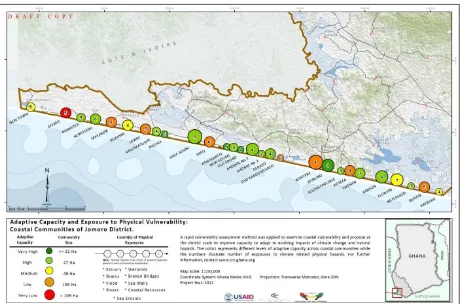
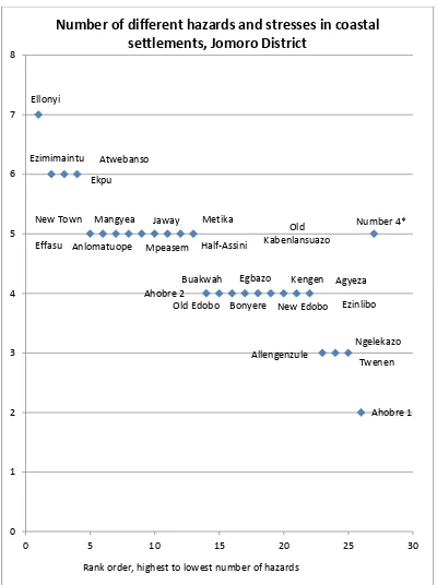
Figure 6 also shows marked variation in adaptive capacity and exposure to hazards across the coastal communities assessed. Elonyin is the community with the highest number of physical exposures while Ahobre No.1 has the lowest. The remaining communities are intermediate between these extremes, with total number of exposures ranging between 3 and 6. It is
worthy to note that there is similarity in physical exposures across almost all the communities in the district. And this is attributed to sea erosion and flood hazards. Other climate and
non-Settlement in
Jomoro District Overall Score/ Potential Total (higher is better) total possible score on the 8 adaptive capacity areas)
hazards a community is exposed to. Thus a community exposed to only one stress factor can be devastated by that hazard within a short period. Nonetheless, where the number of
physical exposures appears to be relatively high and adaptive capacity remains weak,
practical steps need to be taken to improve capability to plan for and respond to change at the community level. This is exemplified by the case of Effasu, Old Kabulensuazo, Bonyere, Ekpu, Anlomatoupe and Elonyin as shown in Figure 6.
Figure 7 Number of hazards and stresses in Jomoro's coastal settlements Ellonyi
Ezimimaintu
Ekpu
Atwebanso
New Town
Effasu
Mangyea
Mpeasem Anlomatuope
Jaway Metika
Half-Assini
Old Kabenlansuazo
Buakwah
Old Edobo New Edobo Ahobre 2
Egbazo
Bonyere Ezinlibo Agyeza Kengen
Allengenzule
Twenen Ngelekazo
Ahobre 1 Number 4*
0 1 2 3 4 5 6 7 8
0 5 10 15 20 25 30
Number of different hazards and stresses in coastal
settlements, Jomoro District
Figure 8 Example of exposure analysis for Jomoro coastal settlements
Dimensions of vulnerability and adaptive capacity
In vulnerable coastal communities, such as those in the Jomoro district, the capability to adapt to changes manifest in several forms. The key dimensions of adaptive capacity at the community level are governance and leadership; coastal resources management; risk awareness and emergency response; and economy and society.
Governance and leadership
In most coastal communities in the Jomoro district, local leadership exists but this is fairly strong. Particularly, the interaction between community folks and their local leaders needs some improvement since the level of trust for local leaders is declining and social cohesion at the community level is breaking down as a result. This is particularly pronounced in
communities where the assembly persons are non-residents of the electoral area. Over the years, this lack of communication has negatively impacted the development of most of the coastal communities, since their needs are not adequately represented on the agenda of the district government. Moreover, in communities where conflicts prevail, other leaders from religious and youth groups are more trusted than the Chiefs or assemblymen.
Despite having challenges with leadership, the coastal settlements are relatively peaceful with no major incidents of arson, attacks, thefts and conflicts. On the average, the district attained a rank of 4, on security, law and order (Table 4). And this is indicative of peace and stability in most of the coastal communities.
Coastal resources management
enforcing regulations which will earn us more enemies is not a priority to us’’. This is illustrative of how rules for managing coastal resources are blatantly neglected and not applied. Utilization of the shoreline has been of concern to inhabitants in the coastal communities. Due to the high demand for shoreline space for siting facilities, there is a renewed interest in leasing and allocating portions of the shoreline to potential investors. This will likely displace traditional users of the shoreline for fishing and fish processing. Besides, there are no management plans that inform how the predominantly sandy and fast eroding shoreline in the Jomoro district should be utilized. Set back regulations are not clearly defined, hence facilities are usually sited in the way of hazards which in turn impairs the dynamic functions of the shoreline. Over the past decades, sand winning along the beaches has been a predominant practice on large and small scale basis. Several years of large scale sand winning to supply construction sand has contributed to forced relocation of some communities. This is particularly the case of new Kabenlansuazo which was created some 50 years ago after resettlement of people from Old Kabenlansuazo.
Risk awareness and emergency response
Economy and society
Fishing and farming constitute the key drivers of the local economy and are the major livelihood options practiced in the Jomoro district. However, destructive fishing practices coupled with the regular incidence of algal bloom in the marine environment are resulting in dwindling fish catch and displacing fishery-based livelihoods while threatening food security in the Jomoro district. This problem is aggravated by the prevailing low agricultural
productivity in the district. As shown in Table 4, the coastal communities recorded an average score of 1 relative to livelihoods and the rural economy. This is due in part, to the periodic incidence of algal bloom in the marine environment which has been of much concern, due to its contribution to decline in fish catch. Harmful fishing methods, such as light fishing and use of chemicals have also negatively impacted the fishery. The coconut industry on the other hand, has been deteriorated by the incidence of Cape Saint Paul’s Wilt disease and also due to over-age crop. Meanwhile, the characteristic sandy soils of the district have over the years, failed to adequately support food crop production.
Figure 9 Jomoro Community Adaptive Capacity Scores
Priority actions for improving adaptive capacity at community and district scales
Table 4 reveals that, the district is fairly strong in certain aspects of adaptive capacity such as leadership and local organization, security, law and order, awareness of hazards and attention to the needs of marginalized groups. However, the district demonstrates significant weakness in other areas of adaptive capacity, notably preparedness for emergency, status of livelihoods and economy, ability to manage coastal resources as well as land use planning and decision making. These areas of weakness require more attention and should be the priority for future district scale actions (along the lines recommended in Table 4) to build adaptive capacity against climate and non-climate stressors.
Also, Table 4 reveals the variations existing across communities relative to adaptive capacity. It shows that while some communities are more able to adapt to change, others need urgent assistance in the short term to address their peculiar grim circumstances. This implies that while district-wide actions are necessary to facilitate widespread improvement in adaptive capacity for all coastal communities, priority should also be given some communities and segments of the population that find themselves in particularly worse situations and show relative unpreparedness to adapt to climate and non-climate stressors. Examples of such communities include Old Kabenlensuazo, Anlomatuope, Agyeza, Bonyere and Effasu.
Old Edobo
Jomoro Community Adaptive Capacity Scores
% of potential total score, grouped by District
Table 4 Summary of community level adaptive capacity across eight variables and Jomoro improvement actions Dimension of
adaptive capacity Adjusted score (possible 5)
Jomoro District-wide actions to improve adaptive capacity
Emergency Preparedness
0.15
• Communications • Local organization • Education and awareness • Training
• Incorporate climate and hazards elements into economic development programs; • Assess sector and infrastructure vulnerability,
• Early actions to increase economic resilience in livelihoods; • Assess critical infrastructure (roads, bridges, utilities)
• Prevent ad hoc coastal defenses, favor non-structural solutions and only where properly designed and justified utilize engineered shoreline stabilization
Condition of coastal resources
0.89
• Adopt policies that recognize coastal features and discourage construction in hazardous zones; • Set priority uses matched to sensitivity of coastal areas;
• Assess effectiveness of existing shore defenses; and
• Identify areas where setbacks, retreat, restoration and protection are preferred.
• Incorporate refugia, which are protected areas where wetlands, flood plains and landscape habitats can move to in response to sea level rise and climate change
Land Use Decision Making and
Planning
0.96
• Conduct cross-cutting vulnerability assessment for coastal region as part of 2014 Mid-Term Development Plan;
• Set priorities for coastal development based on dependence of water location and allocate suitable lands for relocation of infrastructure and settlements.
• Designate flood-prone areas and set limits on allowable uses.
• Improve the flood and climate resilience of existing & new housing and business structures in terms of construction and placement.
Dimension of
adaptive capacity Adjusted score (possible 5)
Jomoro District-wide actions to improve adaptive capacity
flood plain management and retention areas
• Introduce low-impact settlement planning, transportation system approaches.
• Carefully planned and implemented resettlement, requires identification of a safer area that meets the needs of residents, including proximity to the fish landing site, agricultural lands, and existing infrastructure such as transportation corridors and water supply facilities.
Attention to the needs of
marginalized
groups 1.56
• Prepare and implement effective early warning messages that reach marginalized groups. • Identify and support women’s contribution to informal early warning systems.
• Develop and implement evacuation and recovery plans that meet the needs of children, elderly and the sick.
• Early actions to increase economic resilience of poor people through diversified livelihood opportunities, especially for women, elderly people, people with disabilities, ethnic minorities, people living with HIV/AIDS and tenant farmers.
• District wide awareness and education coupled with settlement or ecosystem specific vulnerability assessments and adaptation plans;
• Training for engineers, architects, planners and contractors on hazardous sites and best planning, design and construction practices
• Vulnerability assessments and adaption plans for selected communities Leadership and
local organization
2.37
• Develop community cohesion
• Create dialogue platforms to facilitate engagement between community folks and their leaders on issues of common interest.
• Create a transparent process for decision making on disposal of communal lands and other community assets.
• Build leadership skills among the youth in preparation for future roles Security, Law and
Order 3.26 •• Support peace campaigns and other programs that build upon the relative peace in coastal communities. Develop and implement programs to build trust, improve communications and relationships between oil and gas companies and frontline communities.
2.2 Ellembelle District Summary
Physical impacts of hazards and climate change
The physical hazards facing coastal communities in the Ellembelle district are similar to those observed in other coastal districts in the Western region. These hazards comprise the following 9 broad categories: presence or proximity to a river; proximity to an estuary; high water mark in settlement; presence and or functionality of sea defense walls; condition of coastal bridge; flood risks; a history of coastal erosion; community backed by a wetland and presence of dynamic coastal features along the beach. Each community is exposed to at least, one kind of hazard which is not only a source of physical vulnerability but also a potential threat to livelihoods and well-being of community inhabitants. As shown in Figure 11,
overall, the physical hazards facing communities in this district range between 1 and 5. While 7 out of the total 18 communities are exposed to less than 3 physical hazards, the remaining 11 communities are confronted with a minimum of 3 and maximum of 5 physical hazards and climate-related risks (Figure 10).
In these communities, key assets that are exposed and also sensitive to hazards include artisanal fishing settlements and associated landing sites as well as fish habitats. Other
Figure 11 Number of hazards and stresses in Ellembelle’s coastal settlements
Asanta
Anochie
Baku
Ngalepkole Eikwe
Bakanta-akonu
Esiama
Sanwoma Sanzule
Atuabo Kikam
Ngalechie
Krisan Azulenloanu
Asemkor
Boblama
Anyanzinli
Ampain
0 1 2 3 4 5 6
0 2 4 6 8 10 12 14 16 18 20
Number of different hazards and stresses in
coastal settlements, Ellembelle District
Figure 12 Severe flooding in a coastal settlement in Ellembelle attests to the high level of exposure to hazards
Dimensions of vulnerability and adaptive capacity
The conditions that give rise to vulnerability in the coastal communities in Ellembelle District are not only bio-physical but also socio-economic and cultural. The interactions between these drivers of vulnerability undermine the resilience of coastal communities and the natural resources upon which they depend. The extent to which communities are able to respond, adapt to, and recover from climate and non-climate related shocks is a function of their adaptive capacity. In Ellembelle district, adaptive capacity at the coastal community level is expressed in 4 key dimensions - governance and leadership; coastal resources management; risk awareness and emergency response; and the attributes of the economy and society. Average scores obtained by aggregating across the eight indicators of adaptive capacity reveal low relative resilience of these communities (Table 5). These communities should benefit from detailed vulnerability assessments and adaptation planning processes that identifies forward looking actions and builds local capacity for improving livelihoods, building local leadership, facilitating emergency preparedness and ensuring sustainable management of coastal resources.
Governance and leadership
Leadership exists in all the coastal communities and it is fairly strong as indicated in Table 6 (2.33 out of possible score of 5). It is expressed through the traditional chieftaincy system, the religious establishments, organized youth groups and the local government system. In majority of the communities, the chieftaincy system is highly influential in decision-making and also well respected. In such communities, decision-making is participatory and often involve those who will be affected by those decisions. At the same time, such communities adhere to local norms, laws and taboos because their actions are shaped by existing belief systems. In few instances however, the local chiefs have lost prominence and the youth in particular, adhere to instructions from the
communities’ local government representatives but not the former. A classical case is Sanzule, where the youth perceive the local government
representative as more supportive and
representative of their interest and welfare than all other segments of community leadership. As a result, they cooperate better with the local government representative in matters involving community mobilization and collective action.
Coastal communities in Ellembelle district also
manifest relative peace and calm as indicated in Table 6 (2.67 out of possible score of 5). No major incidences of conflicts, attacks, arson and thefts have been recorded in majority of the communities in the past decades. Overall, people feel safe to live in their communities and comply with laws and norms. It is important to note that, in relatively small communities, people generally tend to comply with laws and social norms out of fear of being noticed when they engage in socially deviant behaviors.
Coastal resources management
There is disproportionately high dependence on coastal resources by coastal inhabitants in the Ellembelle district. Majority derive their sources of livelihoods from fishing in marine, riverine and estuarine waters, fish processing in shorefront areas, mangrove harvesting and farming. Consequently, the condition of these resources and their utilization patterns strongly influence the communities’ ability to respond and their capacity to adapt to stressors. There is however, widespread perception at the community level that these resources are in poor condition (1.22 out of possible score of 5 as shown in Table 6). This is due in large part, to either poor coastal resource management practices or a lack thereof, at the community level. For instance, while social norms are generally respected and adhered to in the coastal
communities, such practices are not extended to the management of coastal resources. Also, in instances where clear traditional norms existed for managing coastal resources, such as the Amanzule wetlands, such norms were found to be fast eroding and not being enforced,
because they were perceived to be subservient to statutory laws. Meanwhile,
non-conformance with statutory laws is widespread and is manifest in practices including fishing Table 5 Adjusted Rank order of community resilience (fraction of total possible score on the 8 adaptive capacity areas) Ellembelle District Settlement in
Ellembelle
District Overall adjusted score (higher is better)
with unauthorized gears, beach sand wining and mangrove exploitation. An illustrative case is Esiama, where huge quantities of sand are mined on daily bases for construction purposes, leading to the loss of fish landing site.
The poor management of coastal resources ties in with prevailing land use planning and decision-making processes at both the community and district levels. Planning and land use decision-making requires significant improvement as shown in Table 6 (1.55 out of possible score of 5). In most cases, land use planning and decision-making at the district level fail to respond to the need to maintain coastal ecosystem goods and services and their functions. Infrastructure to ensure sustainable utilization of, and value addition to, coastal resources is generally lacking. Management plans for coastal resources are non-existent. Spatial planning is at its nascent stages and remains weak as regards ensuring broad stakeholder participation and implementation.
Risk awareness and emergency response
In Ellembelle’s coastal communities, awareness of physical hazards and climate-related stressors remain at an average level, as shown in Table 6 (1.86 out of a possible score of 5). These communities are also unprepared to handle local emergency situations as evidenced in Table 6 (0.56 out of a possible score of 5). Except Bobrama, Asemkor and Kikam, the concentration of settlements along the coast - between the sea and large swathes of wetland areas - contributes to the communities’ exposure. This exposure creates high risk of coastal erosion and flooding. Sanwoma for instance, is regularly inundated by tidal waves and impacted by river flooding during storm events, thereby increasing the risk of displacement of people and livelihoods. Generally, the strategies employed to cope with these risks and the mechanisms for responding to hazards include salvaging flood-damaged assets,
self-constructed drainage ways and temporal retreat. These strategies are only piecemeal and insufficient to accommodate the increasingly compounding changes in exposure and accelerating risks. Some residents have acquired land on higher ground for relocation; however, they lack the financial means to construct their own houses.
No formal or informal education programs exist in the various communities to promote risk knowledge and help with adaptation. Neither are there any programs to support the
communities to reduce the potential impacts of the risk they currently face, such as providing access to climate related information for planning and reaction to local emergencies. The National Disaster Management Organization’s (NADMO) approach for helping out during emergency situations is mainly reactive, as evidenced by the provision of post-emergency relief items which are mostly insufficient to address the cause and consequence of climate related impacts and hazards. The Organization does not systematically anticipate and proactively plan to address risks. Past attempts at establishing and training volunteers in communities to assist in emergency situations has also not succeeded due to low motivation among the youth, coupled with resource constraints within NADMO.
Economy and society
the 1960s, as a result of the devastation of coconut plantations on the coast caused by the incidence of Cape Saint Paul’s Wilt disease. The decline of the coconut industry since this period, had ripple effects on pig husbandry which heavily rely on the availability of coconut chaff for feed.
Fishery on the other hand, is also on the decline, as fish catch has reduced progressively over the past decade. The seasonal proliferation of algal blooms in the coastal waters has also resulted in further displacement of fishery-based livelihoods. Current strategies employed to adapt to these changes are varied; majority of the youth for instance, often migrate to, and from nearby towns bordering Ivory Coast to explore the opportunities for trading in general goods and services. The decision to migrate is heavily influenced by the relationships and networks created by potential migrants in the border town. Others have resorted to illegal small scale mining as a coping response. Land owners and family heads are increasingly leasing land, including shorefront areas, in response to the burgeoning demand for housing development and establishment of industrial facilities associated with the emerging oil and gas industry. Overall, these coping mechanisms seem insufficient to facilitate movement out of poverty, especially for the marginalized, who are disproportionately impacted by the stressors.
Priority actions for improving adaptive capacity at Community and District Scales
Table 6 reveals that, the Ellembelle district is fairly strong in certain aspects of adaptive capacity such as leadership and local organization, security, law and order and awareness of hazards. Yet on other aspects such as attention to the needs of marginalized groups,
preparedness for emergency, status of livelihoods and economy, ability to manage coastal resources as well as land use planning and decision making, the district expresses significant weaknesses. These areas of weakness require more attention and should be the basis for future district scale actions (along the lines recommended in Table 6) to build adaptive capacity against climate and non-climate stressors.
Adjusted Rank order of community resilience (fraction of total possible score on the 8 adaptive capacity areas) Ellembelle District
Figure 13 Ellembelle’s Community Adaptive Capacity Scores Atuabo
Esiama
Asanta
0 10 20 30 40 50 60
0 5 10 15 20
Ellembelle Community Adaptive Capacity Scores
% of potential total score, grouped by District
S
co
re
,
%
o
f
to
ta
l
p
o
ss
ib
le
s
co
re