University of Zagreb
Faculty of Science
Department of Geology
Igor Felja
Karstic estuaries along the eastern
Adriatic coast: Late-Quaternary
evolution of the Mirna and Neretva River
mouths
Doctoral Thesis
University of Zagreb
Faculty of Science
Department of Geology
Igor Felja
Karstic estuaries along the eastern
Adriatic coast: Late-Quaternary
evolution of the Mirna and Neretva River
mouths
Doctoral Thesis
Supervisors: Prof. Mladen Juračić
Dr. Alessandro Fontana
Sveučilište u Zagrebu
Prirodoslovno-matematički fakultet
Geološki odsjek
Igor Felja
Krški estuariji duž istočne jadranske
obale: evolucija ušća rijeka Mirne i
Neretve u mlađem kvartaru
Doktorski rad
Mentori: Prof. dr. sc. Mladen Juračić
Dr. sc. Alessandro Fontana
This doctoral thesis was made at Department of Geology, Faculty of Science, University of Zagreb, under supervision of prof. Mladen Juračić and Dr. Alessandro Fontana (University of Padova).
Ova doktorska disertacija izrađena je na Geološkom odsjeku Prirodoslovno-matematičkog fakulteta Sveučilišta u Zagrebu pod vodstvom prof.dr.sc. Mladena Juračića i Dr. sc. Alessandra Fontane (Sveučilište u Padovi).
SPECIAL THANKS TO:
Prof. Mladen Juračić, for great mentoring, infinitive patience and everything I have learned from you. Also, for the huge effort and time spent in discussing, improving and correcting this thesis. For teaching me how to think, read and write in the scientific way. I am aware it was not easy always to work with me. Thanks for your friendship and advices.
Dr. Alessandro Fontana, for mentoring and teaching me many field and laboratory methods and for discussions and suggestions that substantially improved this thesis. Thanks for great and successful collaboration. Thank you for all the field adventures in Israel, Croatia and Italy.
Prof. Vlasta Ćosović for enormous help with my thesis, for positive critics, suggestions and support you gave me in the last 10 years, even since when I was still student. Thank you for always being sincere, honest and direct with me. Thanks for all the conversations and advices.
The committee appointed for dissertation evaluation: Prof. Vlasta Ćosović, Dr. Slobodan Miko and Prof. Ivan Sondi, for positively evaluating my thesis and all suggestions and improvements of the thesis.
Prof. Tomić, for teaching me how to work with students, both on the field and in the classroom. This substantially helped me to enjoy my job. Thank you for your friendship and positive attitude.
Jelena Španiček, my roommate and best friend, for sharing with me all the good and hard times of the PhD adventure. Thanks for all support and friendship you gave to me and all the great moments we shared.
Robert Košćal, for his artwork with figures and images in my thesis. Most of all, for all the discussions, arguments and good time we spent at the bar. Thanks for all “let’s go to just one beer” moments and all the headaches.
Jelena Vidović, for all the help with foraminiferal analyses and interpretations, as well as for positive conversations, support and friendship.
Prof. Darko Tibljaš for mineralogical analyses.
Zoki and Bero, for all the lunches, coffees, drinks wise conversations and laughs we had, it was the best medicine against stress.
Prof. Blanka, for great effort in helping all PhD students with their problems and substantially easing my PhD journey.
Kristina Pikelj, for teaching me wet sieving and sedigraf method, and for all advices.
My students, Diana, Irena, Andrija, Petra, Irena, Ida, Pero, Marino and many more for helping me with analyses. To all of my students for all great experience we shared in the last 6 years.
All Professors, Assistants and employees from Department of Geology, for all help in making of this thesis, for all the great moments and fun in the last 6 years.
Ministry of Science and Education of the Republic of Croatia for financial support of my researches.
Following projects for financial supports of my researches and to all the people and friends involved in these projects:
MendTheGap – H2020-TWINN 2015; Smart Integration of Genetics with Sciences of the Past in Croatia: Minding and Mending the Gap;
Project Sea-level variations and subsidence in Northern Adriatic in the last 130,000 years through geomorphological, stratigraphic and geoarchaeological indicators funded by the University of Padova (Progetto di Ateneo cod.
C91J10000320001, responsible A. Fontana);
Croatian science foundation research project Nanominerals in sediments and soils: formation, properties and their role in biogeochemical processes (HRZZ 2504);
MEDFLOOD project: MEDiterranean sea-level change and projection for future FLOODing;
Project Jednokratni monitoring hidromorfološkog stanja 19 vodnih tijela prijelaznih voda;
Prof. M. Romić and Prof. D. Romić, for opportunity to work on the two cores from Neretva River delta plain (NER120 and NER20) and one core from Mali Ston Channel (P1); Helena for helping me with analyzing the samples and statistical methods.
Ines, Milko, Nada, Jadranka, Andreja and Anita from the Ruđer Bošković Institute, for teaching me how to work in laboratory, and for teaching me all about 14C method.
Ale, Mladen, Stefano, Sandro, Petra and Irena for helping in the field work and drilling of the cores.
Geoservizi Inc. for drilling and extracting of the long core (MIR1) from the Mirna River delta plain.
My family, for love and support.
My friends, especially Krešo, Ivan, Paolo and many others for all the great times and laughs during this stressful journey.
Danijela, for your love, patience and support. I wouldn’t make it without you.
To everybody who had any impact on me during my PhD journey, thank you for helping me finish this adventure.
BASIC DOCUMENTATION CARD
University of Zagreb
Faculty of Science Doctoral Thesis
Department of Geology
KARSTIC ESTUARIES ALONG THE EASTERN ADRIATIC COAST: LATE-QUATERNARY EVOLUTION OF THE MIRNA AND NERETVA RIVER
MOUTHS
IGOR FELJA
Faculty of Science, Department of Geology, Zagreb
Abstract: Sedimentological, macro- and micropaleontological analyses on sediment cores were carried out in the lower section of the Mirna and Neretva River valleys, in order to study depositional facies and environmental evolution during Late Pleistocene and Holocene. The Holocene marine transgression reached river valleys several
kilometers upstream from the present-day coast, while in the last 7000 – 6000 years it was followed by progradation of the Mirna and Neretva intra-estuarine deltas. Sediment cores recorded these changes and each depositional environment contains distinctive sedimentary characteristics and fossil assemblages which reflect conditions in which sedimentation and life were occurring. This study highlights the potential role of hand augering in sampling and describing the subsoil for reconstruction of the
geomorphological evolution of the area and supporting the study of past relative sea levels, climate changes, and impact of anthropogenic activities.
Key words: karstic estuary, intra-estuarine delta, Holocene, environmental changes, sea-level changes, foraminifera
Thesis contains: 169 pages, 64 figures, 22 tables, 10 appendixes, 2 plates and 233 references.
Original in: English
Thesis deposited in: National Library and Library of the Geological department of the Faculty of Science
Supervisors: Prof. Mladen Juračić; Dr. Alessandro Fontana
Reviewers: Prof. Vlasta Ćosović Dr. Slobodan Miko Prof. Ivan Sondi
TEMELJNA DOKUMENTACIJSKA KARTICA
Sveučilište u Zagrebu
Prirodoslovno-matematički fakultet Doktorska disertacija Geološki odsjek
KRŠKI ESTUARIJI DUŽ ISTOČNE JADRANSKE OBALE: EVOLUCIJA UŠĆA RIJEKA MIRNE I NERETVE U MLAĐEM KVARTARU
IGOR FELJA
Prirodoslovno-matematički fakultet, Geološki odsjek, Zagreb
Sažetak: Sedimentološke, makro-paleontološke i mikro-paleontološke analize radile su se na sedimentnim jezgrama izvađenim iz deltnih ravnica rijeka Mirne i Neretve, s ciljem da se prouče i rekonstruiraju taložni facijesi i evolucija okoliša tijekom mlađeg pleistocena i holocena. Transgresija u holocenu dosegnula je uzvodno u riječne doline nekoliko kilometara od današnje obalne linije, a u posljednjih 7000-6000 godina uslijedila je progradacija delti u estuarijima rijeka Mirne i Neretve. Sedimentne jezgre sadrže zapis tih promjena, a svaki taložni okoliš sadrži karakteristične sedimentne značajke i fosilne zajednice koje odražavaju uvjete u kojima se odvijala sedimentacija i život. Ovo istraživanje naglašava potencijalnu ulogu ručnog uzorkovanja jezgri u opisivanju sedimenata, u svrhu rekonstrukcije geomorfološke evolucije područja i upotpunjava znanje o promjenama relativne razine mora, klime i utjecaja antropogenih aktivnosti.
Ključne riječi: krški estuarij, estuarijska delta, holocen, promjene okoliša, promjene razine mora, foraminifere
Rad sadrži: 169 stranica, 64 slika, 22 tablice, 10 dodataka, 2 table i 233 literaturnih navoda.
Jezik izvornika: engleski
Rad je pohranjen u: Nacionalnoj i sveučilišnoj knjižnici i knjižnici Geološkog odsjeka Prirodoslovno-matematičkog fakulteta.
Mentori: Prof. dr. sc. Mladen Juračić, Dr.sc. Alessandro Fontana
Ocjenjivači: Prof. dr. sc. Vlasta Ćosović Dr. sc. Slobodan Miko Prof. dr. sc. Ivan Sondi
CONTENT:
1. INTRODUCTION ... 1
1.1.BACKGROUND ... 1
1.2.RESEARCH AIMS AND OBJECTIVES ... 2
2. RESEARCH CONTEXT ... 4
2.1.SEA-LEVEL CHANGES: CAUSES AND EFFECTS ... 4
2.2.RELATIVE SEA-LEVEL INDICATORS ... 4
2.3.LATE QUATERNARY SEA-LEVEL CHANGES: CAUSES AND EFFECTS ON THE COASTLINE AND HUMANS IN MEDITERRANEAN AND ADRIATIC ... 7
2.3.1. MIS5 (130,000-71,000 BP); MIS4 (71,000-58,000 BP); MIS3 (58,000-29,000 BP); and MIS2 (29,000-14,000 BP) ... 8
2.3.2. LGM through the early Holocene (18,000-7000 BP) ... 9
2.3.3. Middle and Late Holocene (7000-2000 BP) ... 10
2.4.DEVELOPMENT AND EVOLUTION OF RIVER MOUTHS IN RELATION TO SEA-LEVEL CHANGES (DURING LATE QUATERNARY) ... 11
2.4.1. Estuaries: definition, classification and importance ... 11
2.4.2. Development of recent estuaries and their stratigraphic organization ... 13
2.4.3. Controlling factors on estuarine stratigraphy ... 15
2.4.4. Sediment composition in the estuary ... 17
2.4.5. Intra-estuarine deltas ... 21
2.4.6. Recent and future trends ... 24
2.5.EASTERN ADRIATIC RIVER MOUTHS ... 24
3. STUDY AREA ... 26
3.1.MIRNA RIVER DELTA ... 26
3.1.1. General characteristics ... 26
3.1.2. Geological setting ... 27
3.1.3. Archeological setting ... 28
3.2.NERETVA RIVER DELTA ... 30
3.2.1. General characteristics ... 30 3.2.2. Geological setting ... 31 3.2.3. Archeological setting ... 33 4. RESEARCH METHODS ... 35 4.1. CORE SAMPLING ... 35 4.2.FIELD DESCRIPTION ... 37 4.3.LABORATORY ANALYSES ... 39 4.3.1. Granulometric analyses ... 40
4.3.2. Carbonate content analyses ... 40
4.3.3. Mineralogical analyses ... 41
4.3.4. Foraminiferal analyses ... 42
5. RESULTS ... 43
5.1.FIELD AND LABORATORY DESCRIPTIONS AND RESULTS OF THE LABORATORY ANALYSES OF CORES FROM THE MIRNA DELTA PLAIN ... 43
5.2.FIELD AND LABORATORY DESCRIPTIONS AND RESULTS OF THE LABORATORY ANALYSES OF CORES FROM THE NERETVA DELTA PLAIN ... 68
6. DISCUSSION ... 94
6.1.DEPOSITIONAL ENVIRONMENTS RECORDED IN THE MIRNA RIVER DELTA PLAIN CORES ... 94
6.1.1. Alluvial/deltaic environment (alluvial plain (Aa); freshwater swamp (Ab)) ... 94
6.1.2. Transitional environments (brackish/salt marsh (Ba); inner estuary (Bb)) ... 96
6.1.3. Central/outer estuarine environments (E) ... 97
6.2.EVOLUTION OF THE MIRNA RIVER ESTUARY DURING LATE PLEISTOCENE AND HOLOCENE ... 101
6.3.DEPOSITIONAL ENVIRONMENTS RECORDED IN THE NERETVA RIVER DELTA PLAIN CORES ... 111
6.3.1. Alluvial/deltaic environment (alluvial plain (Aa); freshwater swamp (Ab)) ... 111
6.3.2. Transitional environments (brackish/salt marsh (Ba); inner estuary (Bb)) ... 112
6.3.3. Central/outer estuarine environments (E) ... 113
6.3.4. Evolution of depositional environments in the protected side-valley (cores NER5 and NER6) ... 113
6.4.EVOLUTION OF THE NERETVA RIVER ESTUARY DURING LATE PLEISTOCENE AND HOLOCENE ... 117
6.4.1. Sedimentation in the Mali Ston Channel and evolution of the Neretva prodelta area... 125
6.5.KARSTIC ESTUARIES ALONG THE EASTERN ADRIATIC COAST AND THEIR SIGNIFICANCE IN RECONSTRUCTING SEA-LEVEL CHANGES DURING LATE QUATERNARY ... 127 7. CONCLUSIONS ... 132 8. LITERATURE ... 135 9. APPENDIX ... 147 10. EXPENDED ABSTRACT ... 159 11. CURRICULUM VITAE ... 167
The list of used abbreviations and symbols: ~ (app.) – approximately
AD – years after Christ BC – years before Christ BP – years before present
FOBIMO – FOraminiferal BIo-Monitoring HST – highstand system tract
LGM – Last Glacial Maximum LST – lowstand system tract MIS – marine isotope stage msl – mean sea-level rsl – relative sea-level sp. – species
1. INTRODUCTION
1.1. BACKGROUND
The eastern part of the Adriatic coast is built mostly of carbonate rocks, and in prevailing humid climatic conditions, chemical weathering of limestone and dolomites
dominates. Along the eastern Adriatic coast, during the Quaternary, the karstic processes have been intensive and the terrigenous (riverborne) load reaching the sea was limited. In such conditons rivers at their mouth in the Adriatic Sea formed a specific type of estuaries that has been described as karstic estuaries (Juračić, 1992; Pikelj & Juračić, 2013). Karstic estuaries formed on a karstic bedrock require coastal environment with low energy (sheltered position of the river mouth and low tidal range) and are characterised by the small input of riverborne terrigenous material due to prevalent dissolution of carbonates in the catchment (Juračić, 1992). However, there are some river systems, e.g. Neretva, Mirna or Raša rivers, (Figure 1.1.), which have somewhat higher terrigenous load, due to the fact that they are allogenic karstic rivers. Therefore, they are the only rivers in Croatia which developed noticeable deltas at their mouths during Holocene.
Figure 1.1. The Adriatic Sea and Croatian and Italian coastline, with locations of Mirna and Neretva River delta plains. Rivers are marked in the blue lines.
Slika 1.1. Karta Jadranskog mora s hrvatskom i talijanskom obalom, s označenim lokacijama deltnih ravnica rijeka Mirne i Neretve.
Development of the late Quaternary coastline was related to oscillations in the sea-level caused by alternation of glacial and interglacial periods during Pleistocene and Holocene (Lambeck & Chappell, 2001; Clark et al., 2009). In the Last Glacial Maximum (LGM,
29,000-19,000 years BP, Clark et al., 2009), when sea level was ~120 m lower than today, rivers on the eastern side of Adriatic basin carved their valleys in the carbonate basement. Since the end of the LGM, about 19,000 years ago, large volumes of ice were melted and sea level was rising rapidly, leading to a global transgression, that flooded vast coastal areas, including the Adriatic basin. The Adriatic Sea flooded karstic river valleys along the eastern shores and deep karstic estuaries were formed, including those of Neretva and Mirna River. Sea-level rise slowed down in the last 7000-6000 years (Antonioli et al., 2009; Vacchi et al., 2016) which caused gradual filling of estuaries with terrigenous load and formation of intra-estuarine deltas (Dalrymple, 1992; Stanley & Warne, 1994; Semeniuk et al., 2011).
The paleoecological analyses of the foraminifera and mollusc assemblages, especially benthic foraminifera, that are abundant microorganisms in the shallow and marginal-marine environments (Murray, 2006), were useful in the analysis of Holocene sea-level changes and in paleoenvironmental reconstruction of estuarine systems (e.g. Ruiz et al., 2005, Delgado et al., 2012, Durand et al., 2016). In all marine environments, but especially in these transitional environments, foraminifera distribution is controlled by several environmental parameters such as salinity, sediment grain size, subaerial exposure and organic carbon content (Ruiz et al., 2005).
Transitional environments developed at, or near, mean sea-level (msl), e.g. salt marshes, are particulary useful in reconstructing past sea-levels (Scott & Medioli, 1978; Gehrels, 1994; Edwards & Horton, 2000). In order to date sea-level precisely, other factors such as compaction of sediments and subsidence in the area must be taken into account as well.
1.2. RESEARCH AIMS AND OBJECTIVES
This PhD thesis has been planned and developed aiming at the following goals:
1. To describe Late Pleistocene and Holocene succession of depositional facies in karstic river mouths, recorded in the terminal sectors of the Mirna and Neretva River valleys.
3. To study past relative sea levels, climate changes and anthropogenic activities that occurred during the “Post-LGM” period.
Sea-level changes occurring during Late Pleistocene and Holocene strongly influenced the evolution and development of different environment in the river mouths. Each
environment contains distinctive sedimentary characteristics and fossil assemblages which reflect conditions in which sedimentation and life were occurring. Hence, deposited sediments recorded these changes.
This study should help in the reconstruction of past relative sea levels and climate changes in the area of the eastern Adriatic Sea (which is relatively poorly investigated so far) but also in Mediterranean, during Late Pleistocene and Holocene. Moreover, results of this study could contribute to better understanding of the evolution of intra-estuarine deltas and to their protection and sustainable use.
In this work the use of hand augering in sampling and describing the subsoil down to 13 m depth was tested, suggesting that, due to its cost-effectiveness, it is potentially useful in sampling other low-lying areas along the eastern Adriatic coast that are sometimes remote and not easily accessed with the standard mechanical boring equipment.
2. RESEARCH CONTEXT
2.1. SEA-LEVEL CHANGES: CAUSES AND EFFECTS
Sea-level changes were common during the history of the Earth and had most
significant role in the development and shaping of the different coastal environments, which is still very pronounced today. Most researches of the sea-level changes are focused on the Quaternary period (last 2.59 million years), which is characterised by major climatic oscilations (alternations of glacial and interglacial periods). The basic cause for these variations are mainly related to the cyclic changes in orbital parameters of the Earth causing variations in solar radiations on the Earth surface (Fairbanks, 1989) which caused
accumulation and melting of the large volumes of ice (Lambeck & Chappell, 2001).
It is important to distuinguish eustatic (global) sea-level changes and relative (local) sea-level changes (Van de Plasche, 1986), which are related to changes of the sea-level position in relation to land. Relative sea-level is sum of eustatic, tectonic, compaction and glacio-isostatic parameters (Van de Plassche, 1986; Lambeck & Chappell, 2001; Lambeck et al., 2004a).
2.2. RELATIVE SEA-LEVEL INDICATORS
Relative sea level (rsl) indicators measure both eustatic sea-level and the sum of all vertical land movements (caused by tectonics, sedimentary compaction and/or isostasy) that affected the indicator since its formation (Hijma et al., 2015; Horton & Shennan, 2009; Rovere et al., 2016, and references therein). Sea-level indicators require stabilization of sea level, for at least a short period, in order for them to form and preserve in the long-term.
Sea-level indicators can be divided into following categories: 1. Erosional (e.g. abrasion platforms and marine notches).
Important erosional sea-level indicators are marine notches and abrasion platforms (Figure 2.1.A.). For example, tidal notches can be very precise sea-level indicators, because they are related to the tidal range of the locality where they were formed and the deepest point of the notch is closely correlated to mean sea level (Antonioli et al., 2015 and references
therein). Abrasion platforms are the product of marine erosion on exposed rocky coasts during long periods of stable sea level.
2. Bioconstructionalindicators (e.g. encrustations by marine organsims) Bioconstructional sea-level indicators include coral reefs (Lighty et al., 1982),
vermetid reefs (Laborel, 1986; Sivan et al., 2010), biogenic littoral rims built by the coralline rhodophyta Lithophyllum byssoides (Lamarck) Foslie, 1900 (Figure2.1.B.; Faivre et al., 2013), and borings left on rocky carbonate coasts by molluscs (such as Lithophaga lithophaga
Linnaeus, 1758) or by sponges (Rovere et al., 2015, and references therein).
3. Depositional indicators (e.g. sediments of estuarine or deltaic environment, salt-marsh, beachrock, etc. and their fossil assemblages).
In marginal marine environments, such are those of Mediterranean coastal lagoons and estuarine or deltaic brackish areas, vertical distribution of fossils of foraminifera, ostracoda, diatomea, bivalvia and gastropoda, has proved to be useful for sea level and
paleoenvironmental reconstructions during Quaternary (Vacchi et al., 2016).
Benthic foraminifera are very abundant microorganisms in shallow and marginal-marine environments, and they are widely used in ecological studies (Murray, 2006; Schönfeld, 2012). Because of their short life cycles, high biodiversity and narrow
environmental tolerances (Murray, 1991, 2006), benthic foraminifera are sensitive to short-term environmental changes and due to high preservation potential and abundance in sedimentary records, foraminifera can provide an excellent temporal archive for long-term ecological data over the past hundreds to thousands of years (Yasuhara et al., 2012).
Foraminifera that inhabit salt-marsh environments are especially useful (Figure 2.1.C.), and are one of the most precise depositional indicator (Scott & Medioli, 1978; Gehrels, 1994; Edwards & Horton, 2000). Sediment records in these environments contain specific foraminiferal taxa, which reflects very restricted depth and salinity constraints (e.g., Serandrei Barbero et al., 2006; Shaw et al., 2016).
The sediment deposits in some other marginal marine environments, such are wetlands of the river mouths, coastal lakes and lagoons can also record paleoenvironmental changes related to the sea level changes. Example of these settings are quite common in the
during transgressions and highstands, but were isolated from the sea during lowstands (Taviani et al.,2014; Drinia et al., 2014; Felja et al., 2015).
4. Archeological indicators (e.g. fish tanks, wells, harbors)
Figure 2.1. Examples of erosional, bio-constructional and depositional sea-level indicators: A. tidal notches and abrasion platforms (Israel); B. biogenic littoral rims built by the coralline rhodophyta Lithophyllum byssoides (Lamarck) Foslie, 1900(Faivre et al., 2013); C. coring operation in salt-marsh near the Mirna River mouth, Croatia.
Slika 2.1. Primjeri erozijskih, bio-konstruktivnih i taložnih indikatora razine mora: A. plimske potkapine i abrazijske platforme (Izrael); B. biogeni litoralni obraštaji algi Lithophyllum byssoides (Lamarck) Foslie, 1900 (Faivre i sur., 2013); C. bušenje jezgri u slanoj močvari na ušću rijeke Mirne, Hrvatska.
A
2.3. LATE-QUATERNARY SEA-LEVEL CHANGES: CAUSES AND EFFECTS ON THE COASTLINE AND HUMANS IN MEDITERRANEAN AND ADRIATIC
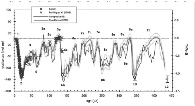
The Quaternary period is divided on marine isotope stages (MIS) based on ratio of stabile oxygen isotopes, 18O and 16O, which are measured in the tests of foraminifera which are one of the constitute of the sea bottom sediments (Emiliani, 1955). Figure 2.2. shows relative sea-level curve and division on the Marine Isotope Stages (MIS) and substages. Generally, glacial or colder periods are marked as even numbers, and interglacial or warmer periods as odd numbers.
Figure 2.2. Relative sea-level curve during part of Pleistocene and Holocene (Waelbroeck et al., 2002). Slika 2.2. Krivulja relativne razine mora tijekom dijela pleistocena i holocena (Waelbroeck i sur., 2002).
Global sea levels in the last 2 million years changed positions between 130 m below the present msl during glacial periods, and 6 m (possibly 13-15 m) above msl during
interglacial periods (Rohling et al., 1998; Dutton et al., 2015; Grant et al., 2014; Spratt and Lisiecki, 2016). In the next subchapters, 2.3.1., 2.3.2. and 2.3.3., a brief overview of the sea-level changes in the period since the MIS5 to the present days is presented, with focus on Mediterranean area (modified after Benjamin et al., 2017, article submitted).
2.3.1. MIS 5 (130,000-71,000 BP), MIS 4 (71,000-58,000 BP), MIS 3 (58,000-29,000 BP) and MIS 2 (29,000-14,000 BP)
The MIS 5 includes several sub-stages that were characterized by both higher and lower-than-modern sea levels, between 6 m above and 30 m below msl (Waelbroeck et al., 2002; Siddall et al., 2003). For most part of the last glacio-eustatic cycle, the eustatic level was tens of metres lower than its present position (Waelbroeck et al., 2002, Grant et al., 2014). The periods when sea-level was low (MIS 4 and MIS 3) and the period when sea-level reached its maximum lowstand (MIS 2) were crucially important in shaping the present Mediterranean and Adriatic basin. During these periods, large portions of the sea-bottom were exposed to subaerial conditions which caused alteration and/or erosion of the pre-existing deposits and coastlines were further seaward than now. Fluvial and aeolian processes, as well as weathering, soil-forming activity and karstification, all took place over large sectors of the Mediterranean coastal areas. Along the eastern Adriatic coast, more than 140 submarine caves with speleothems were documented, some of which were used for sea-level reconstructions (Surić et al., 2005, 2009, 2010). The deepest speleothems found along the Croatian coast are up to 71 m below msl near the Island of Brač in Southern Dalmatia (Garašić, 2006). In many areas the post-LGM sea-level rise eroded and reworked older deposits.
Because of the incomplete sea-level record in the Mediterranean Sea, data from other regions (e.g. the Red Sea, Tahiti) or a ‘global eustatic’ curve are commonly used for the period 116,000-20,000 BP (e.g. Imbrie et al., 1984; Bard et al., 1996; Waelbroeck et al., 2002; Siddall et al., 2003; Rohling et al., 2008).
Transition to MIS 2 was characterized by the sea-level fall at a relatively sharp rate to nearly 80 m below msl, with maximum lowstand between 29,000 and 19,000 BP, when sea level is usually estimated to be between 120 and 140 m below msl (Lambeck et al., 2014).
The marine and coastal evolution after MIS 5.5 and before the Holocene transgression was not recorded in the northern Adriatic, due to geometry of the shelf and the shallow sea bottom (< 20 m below msl) which prevented the deposition of sediments in the coastal and marine environments (Antonioli et al., 2009). In the Po River delta plain, between 75 and 25 m below msl, sediment cores contained deposits dated to MIS 4 and MIS 3, which were formed in an alluvial environment (Amorosi et al., 2004). In the central Adriatic, geophysical researches documented sedimentary traces of regressions, which were occurring during the sea-level fall following MIS 5.5 (Ridente et al., 2009; Maselli et al., 2010).
2.3.2. LGM through the early Holocene (18,000-7000 BP)
Since the end of the LGM, significant volumes of meltwater have been released into the global oceans as a consequence of ice sheets melting which has resulted in sea-level rise of about 120 metres (Fairbanks, 1989; Edwards, 2006; Clark et al., 2009). Sea level rose during the period between 19,000-7000 BP by the average rate of 12 mm/yr and was punctuated by periods of higher rates of sea-level rise (particularly between 14,500-14,000 BP, with rates of more than 40 mm/yr, and lesser rates in Younger Dryas, between 12,500-11,500 BP (Lambeck et al., 2014).
The first significant addition of meltwater started ~ 19,000 BP, with sea-level rose ~10-15 m in less than 500 years (Clark et al., 2004). An even more significant phase of accelerated sea-level rise, known as Meltwater Pulse (MWP) 1A, occurred between 14,500-14,000 BP when global sea-level rose ~16 to 24 m (Lambeck et al., 2014). Other studies have suggested sea-level rise during MWP-1A of 20 metres during the period between 14,300-13,800 BP, as a consequence of melting of both Laurentide and Antarctic ice sheets (Bard et al., 1996, Clark et al., 2002; Rohling et al., 2004; Siddall et al., 2010). Deschamps et al., (2012) dated MWP-1A to 14,650-14,310 BP with sea levels rising 14-18 m, coincident with the Bølling warming in the Northern Hemisphere. They suggested that the rate of eustatic sea-level rise exceeded 40 mm/yr in the period of MWP-1A. This is almost certainly a pace which would be noticeable by coastal occupants during a single generation, particularly in low-lying areas where coastal resources were a significant source of dietary proteins, fuel and other aspects of economy (Broodbank, 2013).
This last deglaciation was abruptly interrupted by the Younger Dryas event, which began ~12,800 BP. During this short interval, the rate of sea-level rise slowed, consistent with the overall cooling in the Northern Hemisphere as documented in Tahiti (Bard et al., 1996, 2010), Huon Peninsula, New Guinea (Edwards et al., 1993; Cutler et al., 2003), Vanuatu (Cabioch et al., 2003), and Barbados (Peltier & Fairbanks, 2006). In the Northern Adriatic, the Younger Dryas cooling led to the formation of a well-developed deltaic complex of Po River. This sedimentary body is partly preserved at a depth ~40 m below msl between 40-60 km offshore of the city of Ravenna (Correggiari et al., 1996; Cattaneo & Trincardi, 1999). Slightly north of this area, some younger lagoon-barrier remnants, testify that the marine transgression occurred during early Holocene. In particular, rsl indicators dating to the interval 11,000 – 10,000 BP were found between 38 and 35 m below msl (Moscon et al.,
2015). Lagoon facies deposits dating between 10,000-9500 BP were found near the coastline of the present mouth of Po River (Amorosi et al., 2008a) and in other sites along the
bathymetric isoline 30 m below msl (Correggiari et al., 1996; Trincardi et al., 2011a,b), while the Adriatic reached the area of Trieste by ~9000 BP (Antonioli et al., 2009; Trincardi et al., 2011a,b).
The average rate of sea-level rise in the period between 11,400-8200 BP was ~15 mm/yr. Meltwater pulse 1B has been reported at ~11,300 BP with slightly higher rise rate of ~16.5 mm/yr for a 500 year period immediately after the Younger Dryas period. This was followed by lower rate of sea-level rise between 8200-6700 BP (Lambeck et al., 2014).
The formation and growth of the Alpine ice sheet during LGM minimally affected the eustatic curve because of its limited volume as compared to polar ice sheets (Lambeck et al., 2004a). The glacial advances in the Alps and partly in the Dinarides and Pyrenees, strongly affected environmental conditions of the northern side of Mediterranean basin. In particular, the fluvial systems of the southern Alps received enhanced sedimentary input supplied by glacial activity, allowing the widespread aggradation and progradation of alluvial fans and megafans, that prograded for tens of kilometres over the exposed shelf in the Adriatic (Fontana et al., 2014).
2.3.3. Middle and late Holocene (7000-2000 BP)
Evidence for middle and late Holocene sea-level changes in the Mediterranean are based on geomorphological evidence (such as tidal notches and beachrocks), fixed biological indicators (such as coralline algae) and archaeological indicators. Holocene sea-level curves have been obtained in Italy (Lambeck et al., 2004a, 2011), Croatia and Slovenia (Antonioli et al., 2007; Faivre et al., 2013), France (Vacchi et al., 2016a); Turkey (Anzidei et al., 2011), Greece (e.g., Pirazzoli, 2005; Vött, 2007). More recently, a comprehensive assessment of Holocene rsl variability along the western Mediterranean coasts was performed by Vacchi et al. (2016b).
Data collected from tectonically stable regions, including negligible isostatic effects (Sivan et al., 2001; 2004; Toker et al., 2012) for the last 4000 years, indicate that sea level was close to present levels between 4000-3600 BP (Galili et al., 2005; Galili & Sharvit 1998; Porat et al., 2008) and has fluctuated below and slightly above the msl since that time (Sivan
et al., 2004; Toker et al., 2012). Between 6800 and 4000 BP, the sea level, in what is now the coast of Israel, rose from -7 m msl to the present level at a rate of 2.5 to 3.5 mm/yr. During the Chalcolithic period (6000-5700 BP) sea level was approximately 2.5 to 5 m below msl. By the Middle Bronze Age (~4000 BP) the sea had reached its present level and the coastline reached its present form. Since then sea level has been relatively stable with possible
fluctuations of no more than 50 cm vertically (Galili et al., 2005, Sivan et al., 2001, 2004; Anzidei et al., 2011).
In the area of the Adriatic Sea, Holocene submersion was largely completed ~7000 BP and subsequently the sea level rose slowly to the current elevation (Antonioli et al., 2007, 2009). The sea-level change occurring in the Istrian coast since about 5000 BP, has been estimated as a relative rise of about 4 m (Faivre et al., 2011). Some authors, such as Benac et al. (2004; 2008), Antonioli et al. (2007), Faivre et al. (2011) and Furlani et al. (2011)
suggested that a sudden Holocene sea-level rise (approximately 0.5–1 m) in the area of the north-eastern Adriatic could have been triggered by an earthquake that submerged the archaeological remains and geomorphological forms (such as marine notches).
2.4. DEVELOPMENT AND EVOLUTION OF RIVER MOUTHS IN RELATION TO SEA-LEVEL CHANGES (DURING LATE QUATERNARY)
2.4.1. Estuaries: definition, classification and importance
River mouths (estuaries and deltas) around the world, are generally well populated evironments of great economic importance (industry, harbors, waste-disposal sites, tourism, fisheries). Additionally, these are sensitive environments of great ecological significance, containing diverse flora and fauna (Dalrymple et al., 1994). From geological point of view, significant quantities of hydrocarbon reserves could be found in older deposits accumulated in such environments (Boyd et al., 2006). Estuaries also have important role in processes such as biogeochemical cycling of elements, transport of nutrients, and filtering of contaminants, which all influence environmental quality of coastal waters.
River mouths are sensitive to both influences from the sea and from the land, and sea-level and climate fluctuations could be used to predict future scenarios of environmental
respone to global change (Tessier, 2012). On the other hand, these environments have been investigated as paleoclimate and paleoceanographic sedimentary archives (Tessier, 2012).
Estuary is an inlet of the sea reaching into a river valley as far as the upper limit of tidal rise, generally divided into three parts: a) an upper or fluvial estuary, dominantly under influence of fresh water but subject to daily tidal action; b) a middle/central estuary, subject to strong saltwater and freshwater mixing; c) a marine or lower estuary, which is under dominant influence of the open sea (Fairbridge, 1980).
Classification of the estuaries should be based on physical and geological parameters that are common to all estuaries but are different from one estuary to another. Estuaries are classified based on physiography (Kinsman & Pritchard, 1965), tidal range (Hayes, 1975), morphology (Fairbridge, 1980), evolution (Dalrymple et al., 1992), or morphogenesis (Perillo, 1995). Perillo (1995) suggested that all previous estuarine classifications were too inclusive and proposed a genetic classification of estuaries: primary and secondary estuaries. Primary estuaries are those that have not been changed significantly by marine processes, whereas secondary estuaries have changed into different forms since their genesis. Estuaries can further be classified into a number of categories such as rias, fjords, delta front estuaries, coastal plain estuaries etc. Karstic estuaries represent special and peculiar form of estuaries, with unique features, which will be described in more detail.
Cooper et al., 2011, proposed classification of estuaries on “keep up”, “catch up” and
“give up” estuaries.
a) “Keep up”estuaries are rare and were developed only when conditions of high
sediment supply kept pace with the very high rates of sea-level rise in the early to mid-Holocene.
b) “Catch up” estuaries were developed when sedimentation was outstripped initially
by sea-level rise, which created a deep water systems; the estuaries were then filled with sediments as sea-level stabilized and fluvial and marine sedimentation
c) “Give up” estuaries developed when sedimentation during the Holocene had been
so low that the incised valley had simply been drowned and preserved. Examples are the rias in Spain and France (Garcia-Garcia et al., 2005), which margins and drainage areas are usually composed of erosion-resistant bedrock.
2.4.2. Development of recent estuaries and their stratigraphic organization
Estuaries were formed in the narrow zone between the sea and the land and their life is generally short. The shape of estuaries is constantly influenced and altered by erosion,
deposition of sediments and sea-level changes. Composition of sediment (lithology and micro- and macrofossils contents) varies depending on the distance of the mouth and the energy of the environment (Kennish, 2016).
As a consequence of glacioeustatic changes during the Quaternary, the estuaries were affected by changes of sea-levels that have ranged over 120 m. During the sea-level
lowstands, continental (subaerial) processes dominated and river valleys were incised into older deposits or basement rocks. Sediments underlying present-day estuaries usually accumulate over an incised valley which is laterally related to a subaerial erosional
unconformity generated during the LGM lowstand. The subaerial unconformity is considered the sequence boundary (Dalrymple et al., 1992). Overlying sediments are composed by variable amounts of deposits of lowstand system tract (LST), transgressive system tract (TST), and highstand system tract (HST), mainly depending on the interplay between
creation of accommodation space led by hydrodynamic factors, relative sea-level rise, and the fluvial supply (Dalrymple et al., 2006). However, in most estuarine systems the bulk of the sediment infilling is considered to be generated during the transgressive and early highstand phases (Dalrymple et al., 1992).
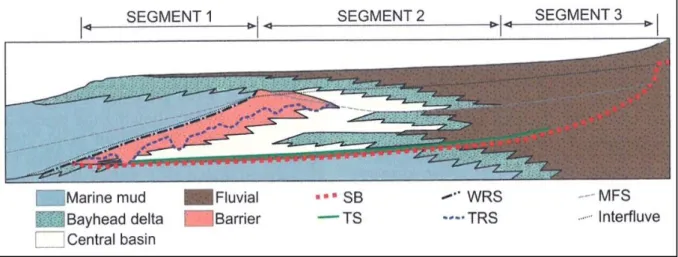
The lowstand unconformity may be covered by fluvial deposits that exhibit very significant variability (Dalrymple et al., 1994). Generally, thick LSTs are favored in narrow incised valleys (Vis & Kasse, 2009). The subsequent transgression would lead to estuarine sedimentation, the composition of which changes along the length of estuary (Zaitlin et al., 1994). Estuarine sediments would be separated from the lower fluvial deposits by an initial flooding (or transgressive) surface (TS) (Figure 2.3.). Transgressive deposits may be finally buried by progradational estuarine deposits generated during highstands with an intervening maximum flooding surface (MFS) between transgressive and highstand deposits (Figure 2.3.)
(Dalrymple et al., 1992). This change may be induced by a decrease in the rate of sea-level rise and/or by an increase of sediment supply (Emery & Myers,1996), causing MFS to be diachronous in most estuarine settings (Chaumillon et al., 2010).
Figure 2.3. Stratigraphic organization of a complete incised-valley succession, divided into three segments. Segment 1 show the seaward portion; segment 2 is the present-day estuarine system; segment 3 remains fluvial during the entire evolution of the system. Legend: SB-sequence boundary; TS-transgressive surface; WRS-wave ravinement surface; TRS-tidal ravinement surface; MFS- maximum flooding surface (Kennish, 2016, modified after Dalrymple et al., 1994).
Slika 2.3. Stratigrafski sklop potpunog taložnog slijeda usječene doline (Kennish, 2016, modificirano prema Dalrymple i sur., 1994).
The sedimentary infill of the present-day estuaries has been mostly generated during the course of the post-LGM sea-level rise (simple infill) although in some cases older
sequences may be preserved in deep incised valleys (compound infill). The base of the infill is generally represented by a LGM incised valley, which may be covered by lowstand (to early transgresive) fluvial deposits (Dalrymple et al., 1994; Chaumillon et al., 2010). Compound estuarine infills preserve lower estuarine sequences below the most recent sequence boundary typically related to LGM. These lower sequences tend to be composed of previous relative highstands deposits (e.g. genesis during MIS3 and MIS5). For example, rias and rocky-bound estuaries tend to preserve older sequences in the deep estuarine sections (Dalrymple et al., 1994; Chaumillon et al., 2010).
The development and progradation of the intra-estuarine deltas (Darlypmple et al., 1992) tends to be fostered during highstand conditions (Allen & Posamentier, 1993),
particulary under circumstances of enhanced fluvial supply and/or reduced wave activity (by sheltering). Intra-estuarine deltas may coexists with distributary mouth bars, a seaward-migrating channel diastem and distal prodelta deposits that further contribute to the growth of the central basin facies (Nichols et al., 1994; Vis & Kasse, 2009).
2.4.3. Controlling factors on estuarine stratigraphy
The factors that control the development of estuarine stratigraphic features, including different methods of formation and preservation of sediment bodies and stratigraphic surfaces, are the following:
1. Bedrock valley morphology
The shape of the valley may influence its subsequent transformation into an estuarine system and the different development of depositional systems (Dalrymple et al., 1992; Boyd et al., 2006). Additionally, the depth of incision controls the preservation potential of infilling deposits, particulary of the lowermost such as LSTs and/or TSTs (Chaumillon et al., 2010).
2. Hydrodynamic processes
Another major factor in determining the lithology and stratigraphy of estuaries is the coastal hydrodynamic setting of an estuary and intra-estuarine hydrodynamics, i.e. whether the estuary is river-dominated, tide-dominated or wave dominated. Estuarine facies
distribution and deposit architecture of the two end-member states (wave versus tide dominance) are variable according to the relative importance of waves and tidal and fluvial currents (Dalrymple et al., 1992).
3. Sea-level fluctuations
The relative sea-level patterns govern the overall stratigraphic change observed in most estuaries from transgressive to regressive conditions, related to a significant decrease of relative sea-level rise (Dalrymple & Zaitlin, 1994).
4. Sediment supply
In general terms, the amount of sediment supply controls sedimentation in estuarine environments. The most extreme case is a “give-up” estuary, where conditions of very reduced sediment supply did not allow an incised-valley fill (Cooper et al., 2011). Low supplied systems are mainly filed with marine sediments, such as the case of French estuarine environments (Chaumillon et al., 2010). In general, those low-suplied estuaries show reduced and absent TSTs. The variability of sediment supply is particulary important during estuarine transgression, as high-sediment supply may account for significant development of estuarine mouth barriers under wave dominance, or high fluvial supply may favor anomalously thick TSTs. In contrast, highstand conditions are generally characterised by increases of sediment
supply, as the decrease in the rate of sea-level rise favors the influence of fluvial sedimentation, accounting for the generation of intra-estuarine deltas that may develop seaward into prodeltaic environments and ultimately leading to significant fine-grained sediment delivery to the shelf. In addition, carbonate production may also be enhanced by highstand conditions, thus increasing the volume of HST (Tessier, 2012).
5. Climate change
The impact of recent climatic variability on estuarine sediment infillings has been addressed in several recent studies, e.g. in northwestern Europe (Tessier at al., 2012; Tessier, 2012). Climate can result in a range of lithologic types and stratigraphic types, particulary in tidal and supratidal environments, and it will determine the extent that fluvial sediment will contribute to the filling of an estuarine basin. It will also have a particular effect on the sediments and stratigraphy of facies that have become emergent and inhabited by tidal and supratidal vegetation (mangroves in tropical humid climate/salt marshes in temperate humid climate).
6. Human influences
The exploitation of drainage basins for human activities in the last few centuries is argued to have caused significant modifications of estuarine sedimentation rates. In particular, a recent period (i.e. the last 1000 years) of increased fine-grained deposition documented in several French estuaries has been related to increased soil erosion by deforestation and agricultural practices (Tessier, 2012). The intensifications of agricultural practices as
triggering mechanisms for bayhead delta growth has also been documented in some estuaries along the Gulf of Mexico coast (Anderson et al., 2008).
Rapid population growth in this favorable areas and overdevelopment of coastal zones place estuaries among most heavily anthropogenically impacted aquatic environments by humans. Major anthropogenic impacts on estuaries can pose a threat to their ecological integrity and long-term viability, like habitat loss and alteration, eutrophication, sewage pollution, overfishing, chemical contaminants, human-altered hydrological regimes, invasive species, sea level rise, subsidence.
Kennish et al. (2014) identified 12 major anthropogenic stressor on estuarine
ecosystems. These include (1) eutrophication; (2) sewage and organic wastes; (3) habitat loss and alteration, shoreline hardening and erosion; (4) chemical contaminants; (5)
human-induced sediment/particulate inputs; (6) overfishing; (7) intensive aquaculture; (8)
introduced/invasive species; (9) human-altered hydrological regimes; (10) climate change; (11) coastal subsidence; (12) floatables/debris.
2.4.4. Sediment composition in the estuary
Sediment composition in estuaries is strongly influenced by the lithology of the catchment, tidal range, wave hights (near the estuary mouth), sediment availability and
sediment transport (Dalrymple, 1992; Bianchi, 2013). Also, estuarine sediment composition is heavily depended on the dominant source of sediment, which is either alluvial or marine.
In estuarine environments, fluvial and marine processes interact, and as a
consequence, a tripartite zonation is observed in most estuaries, reflecting specific energy levels and bedload transport patterns (Dalrymple et al., 1992). These incluse:
1. An outer zone dominated by marine processes; 2. A low-energy central basin;
3. An inner, river dominated zone.
The central basin receives sediments both from the fluvial and marine systems and therefore is an area of net convergence.
Sedimentologically, estuary acts as a basin, semi-protected or nearly fully protected from the sea. Therein, fluvial sediment can be delivered and largely trapped. Marine processes deliver sediments at its seaward portion in an open bay setting, or by marine coastal
transportation processes through narrow inlets or by washover across a low barrier. Estuarine processes within the estuarine basin itself operate to develop intra-basinal sediment, transport and disperse sediment, and develop sedimentary suites from the materials deliverd from fluvial, marine, and intra-basinal estuarine sources. The magnitude of the tidal range for the region where the estuary resides, and/or the extent that the shape of the estuary magnifies the tidal range, will determine how far upstream tidal effects are experienced and to what degree tidal patterns will influence sedimentation patterns (Dalrymple et al., 1992; Dalrymple et al., 1994).
Independently of the estuarine type, sediment compositon in an estuarine environment varies axially and laterally, as well as vertically (Nichols & Biggs, 1985). Towards the head of the estuary, sediment composition includes silts, clays, plants and roots, grading down to sand, gravel and cobbles. Large clay and silt deposits may be found towards the mixed region of the estuary, together with sandy lenses and laminae. Closer to estuary mouth, the main sediments are marine sands with abundant cross-bedding, and tidally driven sandbanks may be found here. Lateral variations also occur, with shorelines composed of sands, gravel, shells, muds, plant fragments and basal peat; subtidal flats composed of laminated muddy sands and sandy muds; and mid-channel environments dominated by coarse marine sands and massive cross-bedding.
Figure2.4. shows large diversity of sedimentary sub-environments/facies that may occur in an estuary.
Figure 2.4. The generalized picture of different environments/facies developed in an estuary. Each of sub-environments/facies may have specific sedimentary features and biota (Kennish, 2016).
The sources and types of sediment that build stratigraphic sequences, their transport mechanism to the estuary, and where the sediment finally is emplaced in the estuary are described below in four systems: the riverine system, the central estuary, the marginal estuarine system and the marine system.
The riverine system is usually a shallow water system. By channel flow and floods, it delivers sand (usually quartz sand), terrigenous mud (usually clay minerals and quartz silt), and gravel to the estuary. While these sediments are mainly located in the estuary headwaters, they can be dispersed into the central parts of the estuarine basin, graded in grain size from coarsest sand at the deltas and river mouths to fine and very fine sand away from the deltas. Riverine mud is the sediment type that is most widely dispersed, and since it is carried in suspension, it can be deposited some distance from the river mouth (Dalrymple et al., 1992; Dalrymple et al., 1994).
The central estuary is a shallow water to moderately deepwater system. The central estuary generates gravel (as invertebrate skeletons), sand (as foraminifera, algal fragments, and fragmented invertebrate skeletons), and mud (as shell fragments, disintegrated algal skeletons, diatomea, and sponge fragments). As with fluvial mud, mud-sized particles generated within estuary are the most widely dispersed. The central estuary is also the location where mud delivered by rivers accumulates, because it is generally the deepest part of the estuary and a low-energy sink (Dalrymple et al., 1992; Dalrymple et al., 1994).
The marginal estuarine system is a shallow water to geomorphically emerged system. It recieves exogenic sediment from a number of sources. Sediment may be reworked and delivered from adjoining uplands, other supratidal locations, or alongshore from elsewhere in the estuary (as sand, mud or gravel), or it may consist of peat from plants inhabiting
shorelines and marginal shallow water environments, or carbonate mud (in marginal lagoons) generated from algal meadows, or mud brought in by suspension on the high tide by storms. Depending on whether the surroundin uplands are rocky, preexisting older sedimentary deposits, or stranded estuarine deposits, the material reworked by sheetwash, shoreline erosion, or fluvial action may be lithoclast (rock) gravel, sand (usually quartz), and mud (Dalrymple et al., 1992; Dalrymple et al., 1994)..
The marine system is usually shallow water environment. The marine system delivers sand (as quartz and marine skeletal material, foraminifera, algal fragments, and fragmented
invertebrate skeletons) and shell gravel to the estuary (Dalrymple et al., 1992; Dalrymple et al., 1994).
2.4.5. Intra-estuarine deltas
A delta is often closely associated in time and space with an estuary (Figure 2.5.), but frequently in the literature the two are not adequately separated, particulary for
tide-dominated estuaries. For the same riverine outlet, a delta is a geomorphic and
sedimentological feature, while an estuary is a hydrochemical one where riverine freshwater flowing into a bay, a lagoon, or semi-enclosed coastal body of water mixes with seawater (Cameron & Pritchard, 1963; Pritchard, 1967; Day, 1981).
Deltas within estuaries generally are relatively small sedimentary accumulations compared to the size of their estuarine setting. They have been variably termed as “bayhead deltas” (e.g. Dalrymple et al., 1992), “river deltas” (Hayes, 1975), and “intra-estuarine deltas” (Semeniuk et al., 2011). As not all of them are located in “bayheads”, the term
“intra-estuarine delta” is used here for those deltas occurring within estuaries.
Figure 2.5. Idealized figure showing the evolution from relatively narrow V-shaped open estuary, with minimal or no sediment fill, then development of intra-estuarine delta and stronger sedimentation inside estuary, to a coastal delta where sedimentary accretion has prograded into the marine environment. Intra-estuarine deltas are present and more clearly evident in estuaries where sediments have not fully occluded them (modified after Kennish, 2016).
Slika 2.5. Idealizirani prikaz evolucije estuarija od relativno uskog estuarija s minimalnom sedimentnom ispunom do potpune progradacije delte unutar estuarija (modificirano prema Kennish, 2016).
In a general perspective, all deltas can be estuarine in the sense that some part of them will have a freshwater-to-seawater transition, and large estuarine environments whose basin has not been filled with sediment may contain small-scale deltas along their margins or in their headwaters (Figure 2.6. and 2.7.).
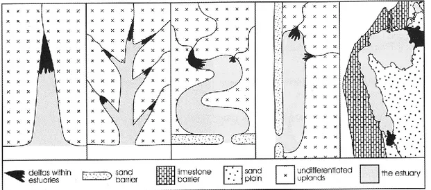
Figure 2.6. Idealized diagram showing a range of estuary types and the occurrence of intra-estuarine deltas (black) inside them (Kennish, 2016).
Slika 2.6. Idealizirani prikaz različitih tipova estuarija i delti unutar estuarija (Kennish, 2016).
Figure 2.7. Idealised diagram showing the dual concept of an estuary within a large delta and a delta within a large estuary (or an intra-estuarine delta). Legend: freshwater = black; brackish water = gray; marine water = white (Kennish, 2016).
Slika 2.7. Idealizirani prikaz koji pokazuje razliku između estuarija razvijenog unutar delte i delte unutar estuarija (Kennish, 2016).
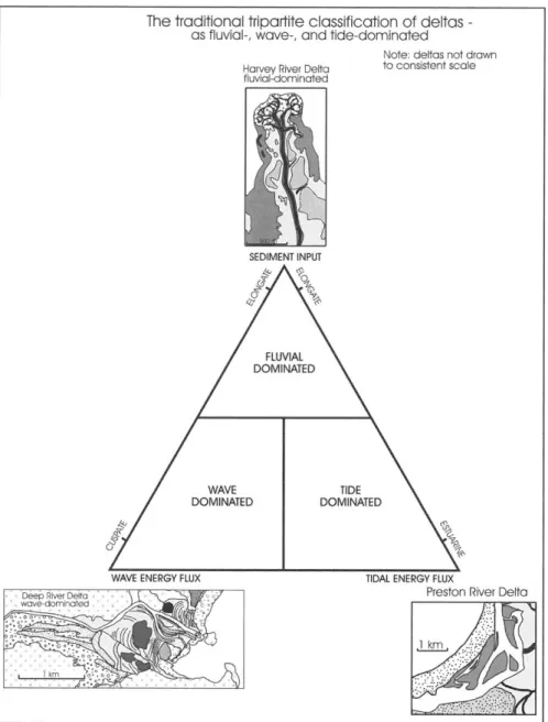
In contrast, deltas in open coastal settings generally are large sedimentary accumulations but are relevant to smaller deltas that occur within estuaries in that the principles involving hydrodynamics, geometry/morphology, mechanisms of constructions, sedimentology and facies, and stratigraphy are similar. Such deltas have been classified as to their plan geometry in response to their hydrodynamic setting as fluvial-dominated deltas, tide-dominated deltas and wave-dominated deltas (Figure 2.8.; Galloway, 1975) or by their depositional architecture and facies (Postma, 1990).
Figure 2.8. The traditional tripartite classification of deltas with some intra-estuarine deltas from southwestern Australia on the ternary diagram (Kennish, 2016, modified after Galloway, 1975).
2.4.6. Recent and future trends
Future research on sediment infill of present-day estuarine systems should be directed at improving the definition of estuarine systems by using different techniques and approaches such as the following (Boyd et al., 2006):
1. Numeric models that can provide a quantitative approach to the major operating processes (sediment flux versus relative sea-level changes) and can be used to predict the future estuarine behavior.
2. 3D seismic data and seabed imagery can enhance visualization of the complexity of estuarine sedimentary environments.
3. Other geological approaches such as brackish ichnology and petrological and chemostratigraphical studies, among others, may be helpful for recognition of estuarine facies and for the subdivision of the estuarine record into different sequences.
4. Improved knowledge of the longitudinal variability of the estuarine infill, because most of the present knowledge involves lateral variability (Tessier, 2012).
5. Better understanding of the influence of anthropic activities in the development of estuarine stratigraphy, which is so far poorly documented (Tessier, 2012).
2.5. EASTERN ADRIATIC RIVER MOUTHS
The eastern coast of the Adriatic Sea is strongly constrained by the structural setting, because the bedrock is composed mostly of Mesozoic carbonate rocks and the tectonic structures are generally elongated in NW-SE direction, leading to the occurrence of a system of valleys that run parallel to the coast. During the Quaternary the karstification was generally dominant in the area and this process led to the development of a limited surface river
network and a small production of terrigenous (riverborne) load.
Between Trieste and Albania only several rivers reach the coast and at their mouth they formed a specific type of estuary that has been described as karstic estuary (Juračić, 1992; Pikelj & Juračić, 2013). Karstic estuaries are characterized by the karstic bedrock, a coastal environment with low energy (sheltered position of the river mouths and low tidal range) and by the lack of riverborne terrigenous material, due to prevalent chemical weathering (dissolution of carbonates) in the catchment (Juračić, 1992). Moreover, some
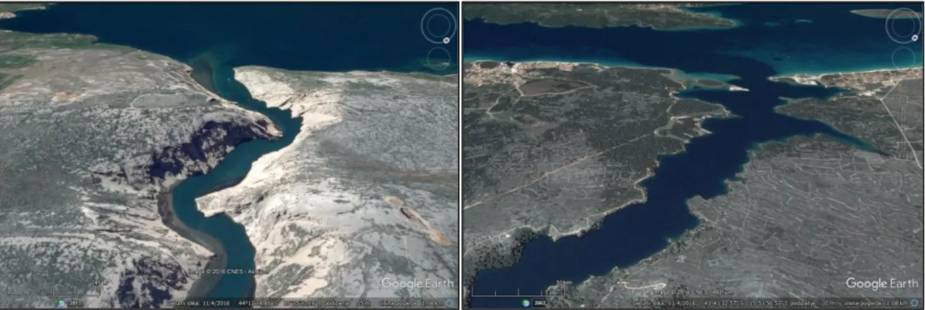
karstic rivers formed tuffa barriers during Holocene, that trapped material and therefore further limited delivery of the material to the sea. Typical low-sediment input karstic estuaries along eastern Adriatic coast are, for example, those of Krka and Zrmanja River (Figure 2.9.).
Figure 2.9. Typical karstic estuaries, along Croatia coast, with limited terrigenous delivery; Zrmanja (left) and Krka (right) estuaries (Google Earth).
Slika 2.9. Tipični krški estuariji duž obale Hrvatske, s ograničenim sedimentnim donosom; Zrmanja (lijevo) i Krka (desno) (Google Earth).
Some karstic estuaries such as those of Dragonja (Ogorelec et al., 1981), Mirna (Felja et al., 2015), Raša (Sondi et al., 1995), Rječina (Benac & Arbanas, 1990) and Neretva River (Vranješ et al., 2007), experienced a intra-estuarine delta progradation during Holocene, due to the larger sedimentary load, supplied by rivers which flow across allogenic formations. This was especially pronounced in the example of Neretva River, characterized by mountain catchment composed of various sedimentary, magmatic, and metamorphic rocks and
sediments. Raša River estuary, is an example of a karstic estuary, which formed intra-estuarine delta during Holocene which is prograding towards sea but did not yet fill the estuary (Figure 2.10.).
Figure 2.10. Progradation of intra-estuarine delta inside the Raša River estuary (Google Earth). Slika 2.10. Progradacija delte unutar estuarija rijeke Raše (Google Earth).
3. STUDY AREA
3.1. MIRNA RIVER DELTA
3.1.1. General characteristics
In the eastern part of the Northern Adriatic region, in Istria, one of the largest deltaic plains is the lower part of the Mirna River valley, with particular environmental
characteristics that have attracted historians, archaeologists and geographers since the end of the 19th century (Carre et al., 2007; D’Incà, 2007 and references therein), but little attention has been paid to the geomorphological and geological aspects. The stratigraphic setting documented in the Mirna River valley should be comparable with the situation found in the terminal tract of the other Istrian rivers, like in that of Dragonja (Ogorelec et al., 1981), Raša (Sondi et al., 1995) and Rječina (Benac & Arbanas, 1990). At the moment, only a few cores are available in those areas and they do not allow detailed description of the late-Holocene depositional units. Holocene coastal evolution is well documented along the western coast of the northern Adriatic, where deltaic progradation started from about 7500 years ago (e.g. Amorosi et al. 2008b and references therein), but the low-lying landscape and lithology is different from Istria.
The Mirna River is located in the north-western part of the Istrian peninsula, western Croatia. It is the longest river in Istria (53 km), with a hydrographic catchment of
approximately 402.9 km2 (Božićević, 2005). Average discharge of the Mirna River is 16 m3/s (Wikipedia). Karst processes strongly affected the carbonate formations of Istria and led to the development of complex and well-developed underground water circulation, thus, beside the surficial orographic basin, the Mirna River has a hydrogeological catchment estimated to ~583.5 km2 (Božičević, 2005). The source of the Mirna River is near the town of Buzet and it discharges into the Adriatic Sea near the town of Novigrad (Figure 3.1.). The Mirna River delta plain (from the river mouth to the Ponte Portone) has a surface of ~15 km2. Drainage area od the Mirna River has relatively warm and humid climate, specifically Cfa and Cfb according to Köppen classification. Mean temperature in January is 4°C, and mean
temperature in July is between 22 – 24 °C. Along the western coast of the Istria Peninsula, annual average rainfall is between 800 – 1,100 mm, and slightly increasing landward (Filipčić, 1992; Božičević, 2005).
Figure 3.1. Location of the study area (Mirna River and its drainage area). The Digital Elevation Model (DEM) obtained from NASA-SRTM data. The boundary of the hydrogeological catchment is assumed (according to SANTIN, 2013) (Felja et al., 2015).
Slika 3.1. Lokacijska karta područja istraživanja (rijeka Mirna i njeno drenažno područje) (Felja i sur., 2015).
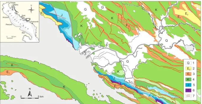
3.1.2. Geological setting
The drainage basin of the Mirna River is composed of carbonates, mostly Cretaceous and Eocene limestone, and clastic Eocene deposits (Figure 3.2.; Polšak & Šikić, 1963; Pleničar et al., 1965). These marl and sandstone sediments in alternation (flysch) in the
catchment area are morphologically related to a badland landscape (Gulam et al., 2014). Since the beginning of the 20th century, a number of karstic springs were documented on
topographic maps of the lower tract of the valley, but they partly disappeared after land reclamation. The Gradole spring is the largest one, with an estimated minimal discharge of 500–600 l s–1 (Magdalenić et al., 1995). From a structural point of view, the area is part of the External Dinarides that are dominated by limestone deposited on the Adriatic Carbonate Platform from the Lower Jurassic to the Eocene (Velić et al., 2002). The Dinarides are characterized by compressional tectonics, with maximum stress aligned NE-SW and thrust and reverse faults that strike NW-SE (Castellarin et al., 1992; Vlahović et al, 2005).
number of very strong earthquakes in the vicinity, such as in the Gulf of Rijeka (Faivre & Fouache, 2003).
Figure 3.2. A geological map of Istria (modified after the Geological Map of Croatia 1:300000, Croatian Geo-logical Survey, 2009); 1. Fault, 1a. Thrust, 2. Quaternary deposits (mainly Holocene), 3. Terra rossa deposits (Holocene). 4. Flysch deposits (Eocene), 5. Liburnia deposits, Foraminiferal limestone and transitional deposits (Paleocene?, Eocene), 6. Rudist limestone (Cretaceous), 7. Dolomite and breccia (Cretaceous), 8 Limestone and dolomite (Cretaceous) (Felja et al., 2015).
Slika 3.2. Geološka karta drenažnog područja rijeke Mirne (Felja i sur., 2015).
3.1.3. Archaeological setting
Istria was reached by Neolithic people between 5800–5600 BC, when the first farmers settled in the area, especially along the coast (Forenbaher et al., 2013). A major phase of occupation occurred in the ancient and late Bronze Age, characterized by the so-called Castellieri Cultural group. This is related to the construction of fortified villages on hills (i.e.
the castellieri), defended by sub-rounded drywalls (Sakara Sučević, 2004). The late Bronze Age population mainly concentrated in few large centres that probably later became the major Roman cities. Romans occupied Istria between the 2nd and 1st century BC and they built a complex network of roads and widespread systems of fields (i.e. centuriatio). At that time, the Mirna River was probably called the Ningus and some historical sources describe the
existence of an important protected harbour, most likely near the present area of Ponte Porton (Parentin, 1974; Carre et al., 2007; D’Incà, 2007). Historical chronicles and maps depict the strong progradation experienced by the river mouth during and after the Medieval Age, up to the present that transformed most of the lower valley into a swampy environment (D’Inca,
2007). Novigrad (Cittanova) became the major city of the area since the Byzantine period and during the Venetian domination the river assumed the name of Quieto, describing its calm flow. A major phase of land degradation occurred between the 12th and 19th centuries, when the Istrian woods supplied the shipyards in Venice (Parentin, 1974; D’Incà, 2007). Historical documents testify to the existence of a harbor near the chapel of S. Maria of the Bastia in 1582 AD and the archaeological evidence documents that at the site of the chapel the valley floor rose about 4.6 m between 1582 and 1857 (Milotić & Prodan, 2014). Since the second half of the 19th century, during the Austrian domination (Figure 3.3.), there have been interventions to regulate the river (e.g., some artificial cutting of meanders), but a large reclamation plan was undertaken during the 1920s–1930s (Parentin, 1974; Santin, 2013). The lower valley of the Mirna was transformed into the present farmland through the construction of artificial levees and a dense network of ditches connected to pumping stations. After the 1964 flooding, the regulation and reclamation works were completed (Santin, 2013).
Figure 3.3. Comparision of the historical maps of the Mirna River mouth of the Second (1806-1869) (Timár et al., 2006) and Third (1869-1887) (Molnár & Timár, 2009) military survey of Habsburg Empire (Mapire.eu/en/). Slika 3.3. Usporedba povijesnih karata područja ušća rijeke Mirne tijekom drugog i trećeg vojnog kartiranja Habsburškog Carstva (Mapire.eu/en/).
3.2. NERETVA RIVER DELTA
3.2.1. General characteristics
Neretva River delta is located in the south-east part of the Adriatic coast (Figure 3.4.) and is the largest river along the Croatian part of Adriatic coast, with a hydrogeologic
catchment (including Trebišnjica stream) of approximately 13,280 km2
(3060 km2 in Croatia). The Neretva River is 215 km long and flows mostly in Bosnia and Herzegovina and only 22 km through Croatia (Slišković, 2014). The Neretva River delta plain covers approximately 170 km2 and consists of Quaternary alluvial deposits (Juračić, 1998). Several watercourses are flowing through the delta plain. These are the main channel of the Neretva River, the Mala Neretva distributary channels, and local tributary streams draining with strong karstic springs (Jurina et al., 2013).
Figure 3.4. Location of the study area (Neretva River delta plain).