Open Geospatial Consortium
Approval Date: 2012-11-23
Publication Date: 2012-12-05
OGC name of this OGC® project document: http://www.opengis.net/doc/bp/wami-primer/1.0
Reference number of this OGC® project document:
OGC 12-077r1
Version: 1.0
Category: Primer
Editors: Rahul Thakkar
A Primer for
Dissemination Services for Wide Area Motion Imagery
Copyright notice
Copyright © 2012 Open Geospatial Consortium.
To obtain additional rights of use, visit http://www.opengeospatial.org/legal/.
Warning
This document is not an OGC Standard. This document is provided as a primer to an approved OGC
Best Practice and is distributed for review and comment. The document is subject to change without
notice and may not be referred to as an OGC Standard.
Recipients of this document are invited to submit with their comments, notification of any relevant
patent rights of which they are aware and to provide supporting documentation.
Document type: OGC® Primer Document subtype: if applicable
OGC 12-077r1
License Agreement
Permission is hereby granted by the Open Geospatial Consortium, ("Licensor"), free of charge and subject to the terms set forth below, to any person obtaining a copy of this Intellectual Property and any associated documentation, to deal in the Intellectual Property without restriction (except as set forth below), including without limitation the rights to implement, use, copy, modify, merge, publish, distribute, and/or sublicense copies of the Intellectual Property, and to permit persons to whom the Intellectual Property is furnished to do so, provided that all copyright notices on the intellectual property are retained intact and that each person to whom the Intellectual Property is furnished agrees to the terms of this Agreement.
If you modify the Intellectual Property, all copies of the modified Intellectual Property must include, in addition to the above copyright notice, a notice that the Intellectual Property includes modifications that have not been approved or adopted by LICENSOR.
THIS LICENSE IS A COPYRIGHT LICENSE ONLY, AND DOES NOT CONVEY ANY RIGHTS UNDER ANY PATENTS THAT MAY BE IN FORCE ANYWHERE IN THE WORLD.
THE INTELLECTUAL PROPERTY IS PROVIDED "AS IS", WITHOUT WARRANTY OF ANY KIND, EXPRESS OR IMPLIED, INCLUDING BUT NOT LIMITED TO THE WARRANTIES OF MERCHANTABILITY, FITNESS FOR A PARTICULAR PURPOSE, AND NONINFRINGEMENT OF THIRD PARTY RIGHTS. THE COPYRIGHT HOLDER OR HOLDERS INCLUDED IN THIS NOTICE DO NOT WARRANT THAT THE FUNCTIONS CONTAINED IN THE INTELLECTUAL PROPERTY WILL MEET YOUR REQUIREMENTS OR THAT THE OPERATION OF THE INTELLECTUAL PROPERTY WILL BE UNINTERRUPTED OR ERROR FREE. ANY USE OF THE INTELLECTUAL PROPERTY SHALL BE MADE ENTIRELY AT THE USER’S OWN RISK. IN NO EVENT SHALL THE COPYRIGHT HOLDER OR ANY CONTRIBUTOR OF INTELLECTUAL PROPERTY RIGHTS TO THE INTELLECTUAL PROPERTY BE LIABLE FOR ANY CLAIM, OR ANY DIRECT, SPECIAL, INDIRECT OR CONSEQUENTIAL DAMAGES, OR ANY DAMAGES WHATSOEVER RESULTING FROM ANY ALLEGED INFRINGEMENT OR ANY LOSS OF USE, DATA OR PROFITS, WHETHER IN AN ACTION OF CONTRACT, NEGLIGENCE OR UNDER ANY OTHER LEGAL THEORY, ARISING OUT OF OR IN CONNECTION WITH THE IMPLEMENTATION, USE, COMMERCIALIZATION OR PERFORMANCE OF THIS INTELLECTUAL PROPERTY.
This license is effective until terminated. You may terminate it at any time by destroying the Intellectual Property together with all copies in any form. The license will also terminate if you fail to comply with any term or condition of this Agreement. Except as provided in the following sentence, no such termination of this license shall require the termination of any third party end-user sublicense to the Intellectual Property which is in force as of the date of notice of such termination. In addition, should the Intellectual Property, or the operation of the Intellectual Property, infringe, or in LICENSOR’s sole opinion be likely to infringe, any patent, copyright, trademark or other right of a third party, you agree that LICENSOR, in its sole discretion, may terminate this license without any compensation or liability to you, your licensees or any other party. You agree upon termination of any kind to destroy or cause to be destroyed the Intellectual Property together with all copies in any form, whether held by you or by any third party.
OGC 12-077r1
Table of Contents
1
Executive summary ... 5
2
Introduction ... 5
3
What is WAMI? ... 6
4
Generated data ... 8
4.1
Data volumes ... 9
4.2
Proprietary formats ... 9
5
Consumer ... 9
6
Operational use ... 10
7
Web services ... 10
7.1
Web services grammar and data formats ... 11
8
WAMI data dissemination ... 11
9
WAMI web services ... 12
9.1
Core services ... 12
9.1.1
Which service to use and when? ... 13
9.2
Alert Services ... 13
9.3
Derived services ... 13
9.3.1
Query Service ... 13
9.3.2
Live WAMI ... 13
9.3.3
Virtual File System ... 14
9.3.3.1
Avoid vendor lockdown ... 14
9.3.3.2
HTTP 1.1 WebDAV ... 15
10
OGC 12-032r2 describes CS, IS and VS ... 16
11
Common model ... 16
11.1
RESTful HTTP ... 16
11.1.1
HTTP request ... 16
11.1.2
HTTP response ... 16
11.2
Required parameters ... 16
11.3
Common WAMI requests ... 16
12
Time ... 17
12.1
Time value KVP syntax ... 17
12.2
Frame based TIME ... 17
12.3
ISO time based TIME ... 18
13
Collection Service ... 18
13.1
Definition of a WAMI data Collection ... 18
13.2
CS data model ... 19
13.3
Summary of all requests ... 19
14
Image Service ... 20
14.1
Summary of all requests ... 20
15
Video Service ... 21
15.1
Summary of all requests ... 21
16
Considerations ... 21
16.1
High latency networks ... 21
16.2
Temporal mismatch ... 21
16.3
Spatiotemporal overlap ... 22
16.4
Rendering maps along a pre-defined path ... 22
16.5
Tile server ... 23
17
Conclusion ... 24
Appendix A: Requests summarized ... 24
A.1 GetCapabilities ... 24
A.2 GetHelp ... 25
OGC 12-077r1
A.4 CS:GetCollections ... 26
A.5 IS:GetMap ... 27
A.6 IS:GetMapInfo ... 29
A.7 IS:GetPathMap ... 29
A.8 IS:GetPathMapInfo ... 30
A.9 VS:GetMapVideo ... 31
A.10 VS:GetPathMapVideo ... 32
Appendix B: Examples ... 33
B.1 GetCapabilities ... 33
B.2 CS ... 35
B.3 IS ... 37
B.4 VS ... 39
Figures
Figure 1: Example WAMI sensor ... 7Figure 2: Six-camera POV ... 7
Figure 3: Six-camera ground coverage ... 7
Figure 4: One ortho-rectified WAMI frame with one AOI zoomed in at 100% ... 7
Figure 5: WAMI image size comparison ... 8
Figure 6: FMV vs. WAMI coverage ... 10
Figure 7: Example VCSS pipeline ... 14
Figure 8: Virtual file system using HTTP 1.1 WebDAV ... 15
Figure 9: Collection tree served by a collection service ... 19
Figure 10: A leaf node is a WAMI collection ... 19
Figure 11: Consistently resolve temporal ambiguity ... 22
Figure 12: Consistently resolve spatiotemporal ambiguity ... 22
Figure 13: Spatial overlap can change over time ... 22
Figure 14: Key-frame animation using GetPathMap and GetPathMapVideo ... 23
Figure 15: Tile based dissemination ... 23
Revision history
Date Release Authors Paragraph modified Description
04/02/2012 Draft R Thakkar All Original draft document
04/12/2012 Draft J Zinter, M Maraist, R Thakkar Edits, info, examples Release candidate
04/20/2012 Draft R Thakkar Exec. summary, examples Release candidate
05/02/2012 Draft R Thakkar Edits, appendix A & B, RS Release candidate
08/30/2012 1.0 R Thakkar Edits for best practice doc For release to OGC
OGC 12-077r1
1
Executive summary
Management of Wide Area Motion Imagery (WAMI) is a growing Big Data problem. Current workflows
have been hard pressed to “simply keep up”. WAMI sensors come in different designs; from single CCDs
collecting big pictures, to a matrix of cameras collecting a larger aggregate view. Gigapixel sensors
collect color, luminance or IR data at more than 8-bits per band, several times a second. Storing WAMI
data raw and uncompressed is ideal, but becomes unsustainable in the long term. Despite compression,
moving the data from a forward source to data centers is still a challenge, even with high bandwidths.
Since 2007, PIXIA Corp has implemented an end to end solution that is sensor and data agnostic,
delivering WAMI quickly and efficiently, no matter where it was located; on the aircraft, in a ground
station, in a local data center or in archives. It required developing unique technologies, one of which was
a set of web services. Using a RESTful HTTP grammar, the services provided a scalable,
high-performance interface for WAMI in a global enterprise. The web services grammar was modeled on
existing standards. Clients could get data from all WAMI sensors that until now required proprietary
interfaces. The services were well received by the WAMI community. In 2011, PIXIA submitted the
specifications to the Open Geospatial Consortium (OGC) for consideration for standardization.
This solution is currently deployed supporting fielded WAMI sensors in a global enterprise.
Name
About
Core services
Collection Service (CS)
An implicitly federated service informs a client of all WAMI data being served with links to content deliver services. It presents a hierarchical view of WAMI data with incremental dissemination capability.Image Service (IS)
Delivers derived WAMI content from bounded areas of interest (AOI) across time over multiple collects as a flipbook of one or more maps and metadata.Video Service (VS)
It is similar to IS. It delivers WAMI content as video.Raw Service (RS)
Delivers original raw WAMI data as it was acquired, unblemished.Alert services
GeoRSS
Implements a pull-based alert service. Uses the GeoRSS schema over RSS.XMPP
Implements a push-based alert service. Uses the GeoRSS schema over XMPP.Derived services
Video Control and
Streaming Service
(VCSS)
It is similar to VS. It provides Digital Video Recorder (DVR) controls over HTTP delivering video windows over different AOIs via HTTP, TCP, or UDP. Consumers can play forward, backward, pause across all data, and go-to-live. They can pan around; zoom in and out.
Query Service (QS)
This service provides a search capability atop multiple CS. Use of existing negotiated NoSQL industry standard interfaces is recommended.Virtual File System
(VFS)
Provides a POSIX file system view atop WAMI frames as a set of folders and files using HTTP 1.1 WebDAV. Circumvents vendor lock-in and supports file-based apps to function, giving them migration option and opportunity.
2
Introduction
The reason for developing this specification was a WAMI community requirement to deliver high
performance web services and disseminate WAMI products. While existing web services can be
OGC 12-077r1
The services are consumer centric. The services deliver only as much as was requested and no more. The
services deliver little to a lot of data based on the requests. The services deliver incremental data. Multiple
modalities in the quantity of data delivered permits optimal server development/deployment capabilities
across networks of various latency and bandwidth behaviors.
Clients can choose from a menu of capabilities and develop a UX to best suite consumer needs. Servers
are judged on their ability to deliver raw performance and their ability to scale across an implicitly
federated global enterprise. The services are modeled for implementation on inexpensive commodity
compute and storage infrastructure permitting cloud vendors to run these at the platform layer.
PIXIA Corp has submitted document number OGC 12-032r2 for consideration as a standard for
dissemination of Wide Area Motion Imagery (WAMI) data and metadata. OGC 12-032r2is titled
OGC
WAMI Services - Dissemination Services for Wide Area Motion Imagery
. Every attempt was made to
make the specification compliant with OGC standards. Web services based on this document have been
deployed and are in use by the community. The document is currently under review as a best practice
document.
Specifications are generally dry documents. This document serves as a primer for OGC 12-032r2. It
introduces WAMI and the WAMI services specifications as submitted in OGC 12-032r2. It is intended
for audiences that wish to review, understand, comment on, or implement using OGC 12-032r2. Portions
of this document may apply to different audiences. Feel free to skip over parts that are not relevant to you.
3
What is WAMI?
OGC 12-077r1
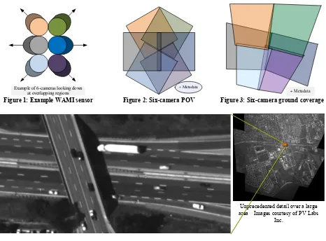
Example of 6-cameras looking down at overlapping regions
Figure 1: Example WAMI sensor
+ Metadata
Figure 2: Six-camera POV
Metadata
Figure 3: Six-camera ground coverage
Unprecedented detail over a large area Images courtesy of PV Labs
Inc.
Figure 4: One ortho-rectified WAMI frame with one AOI zoomed in at 100%
Simply put, WAMI captures a
video
of an area the size of a town or city, day and night. It is a system that
uses one or more
cameras
mounted on the some form of a gimbal on an aircraft or blimp to capture a very
large area on the ground, from about once every second up to several times per second.
Persistent
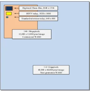
OGC 12-077r1
1.6 Gigapixels
40,000 x 40,000 pixel image Next generation WAMI 144 Megapixels
12,000 x 12,000 pixel image Commercial WAMI
Standard television today, 640 x 480 HDTV today, 1920 x 1080 Digitized 35mm film, 2048 x 1536
Figure 5: WAMI image size comparison
For example, a WAMI sensor may have six high resolution cameras that may take pictures about twice a
second. Set to look down and face outwards from each other at a slight angle, a picture from each camera
overlaps pictures from adjacent cameras. The system is mounted inside or outside an airborne platform.
The platform also has GPS / IMU capability. The system records pictures, and position data.
Using this information, for each instant in time, a software tool can combine separate images into one
large image. It can perform image processing operations using digital elevation models (DEMs) to
generate fairly accurate maps many times a second. Each map may have geo-spatial data, a sub-second
time of acquisition, and additional metadata complimenting the captured data. WAMI can be used for
pattern analysis such as tracking, forensics, and fused with sensors to create a common operating picture.
Different sensors may implement radically different technologies. Sensors may change from being a
mosaic of CCDs, a single large CCD, or a mosaic of multiple cameras. The end result is a big picture of a
vast region on the ground taken frequently. An example is shown in figures 1 to 4.
4
Generated data
Consumers may need data in its unmodified format and as a derived product e.g. ortho-rectified image.
Both can be utilized for a variety of spatiotemporal analyses.
OGC 12-077r1
ranges. An example WAMI image may contain 60 MB to 12 GB or more of uncompressed data.At1600
megapixels or 1.6 gigapixels per frame, one WAMI image would be 772 times larger than full HD.
4.1
Data volumes
Data volumes quickly become an issue. To illustrate this, let us focus on WAMI as derived ortho-rectified
image maps. One150-megapixel color WAMI image frame at 8-bits per band uncompressed is about 450
MB. At 10:1 compression, it is45 MB/frame. At 2 frames per second, 86,000 frames cover 12hours at3.7
TB per day per sensor. At night, the same sensor would have one IR band instead of 3-bands and could be
at 16-bits/band, resulting in about 2.5 TB of data for the night time. 1.6Gigapixel sensor scan create over
100 TB a day. Moving so much data electronically is impractical. It is acquired at a one location and
needs processing at another location. Clients may need data on board a platform, from local
ground-stations, and archives in data centers. Maintaining multiple copies is cost prohibitive.
4.2
Proprietary formats
To understand consumption of this data, let us relate it to aerial and satellite imagery as it is captured
today. GIS consumers of satellite and aerial imagery get the data as maps. Generally, raw camera data is
either rasterized with rational polynomial coefficients (RPCs), or ortho-rectified into a known coordinate
reference system and presented as a map mosaic.
WAMI sensors have been fielded by the US Government and commercially. Sensors pack different
technologies. They deliver different effective megapixel ratings at various frame rates from 1 to 10 fps
that may be non-constant. The format in which camera data is delivered is almost always proprietary.
Map generator tools are also proprietary. Consequently sensors require special integration. Some sensors
directly produce an ortho-rectified image per frame in a standardized file format such as GMLJP2, time of
acquisition (TOA) and additional metadata. Regardless of the captured format, data transmission is a
problem. Vendors have used everything from FTP to custom TCP sockets to JPIP with varied success.
5
Consumer
A consumer of this data can be a human analyst or an automatic data processing algorithm. At some
point, either humans or algorithms need WAMI imagery in some form.
OGC 12-077r1
From a consumer’s perspective, if they have access rights to the data, there should be no difference in the
client experience whether the data is on the ground or being captured live, directly from the capture
platform, raw or derived.
6
Operational use
The introduction of WAMI to operational users provided a monumental gain in Intelligence, Surveillance,
and Reconnaissance (ISR) collection and exploitation. Considerable Geospatial Intelligence (GEOINT)
was available from a single platform. Full Motion Video (FMV) platforms provided a small field view on
a specific target or area of interest. WAMI provides persistent coverage over large areas which previously
required multiple FMV platforms.
Operational commanders can send a single
platform over an area of interest. Both
forward operators and exploitation centers in
the rear can use this data to meet their
objectives.
To meet their objectives, exploitation centers
employ different Electronic Light Table
(ELT) software. These ELT packages can
use the proposed standard to stream and
exploit WAMI data. This is a positive shift
in implementing services to meet changing
ISR needs without impacting their
architecture. The exploitation workflow is beginning to employ more automatic methods to consume
imagery which in-turn generate more data, such as tracks, events, moving target indicators (MTI), and
video clips.
Current initiatives will applyinnovative methods to analyze exploding amounts of big data. New analytics
tools will generate what is known as activity based intelligence (ABI) from WAMI. The value of WAMI
increases when merged with sources such as Light Detection and Ranging (LiDAR), Hyperspectral
Imagery (HSI), National Technical Means (NTM) imagery, aerial maps, Synthetic Aperture Radar (SAR),
FMV, traffic cameras, and metadata feeds such as ABI metadata, ground moving target indicators(GMTI)
tracks, and signal intelligence (SIGINT).
7
Web services
To retrieve data in forms stated above, a consumer needs global access to WAMI data. This is a problem
of communication, performance and scale. If we break the general problem of WAMI data dissemination
down into smaller problems, each standing by itself, we can address them separately and simply. This
approach produces functional, modular, small, and independent solutions.
Data is remote, often times in limited compute environments. It is hard for a client to be next to the data.
This solution should make it so that it is not necessary for a data consumer to be next to the data.
Therefore, each independent solution is a web service, implementing a well-designed grammar meant for
OGC 12-077r1
today’s defense networks and the Internet. WAMI web services define the grammar. The format is
controlled by various format standardization bodies. Customers dictate which format is required by them.
Service implementations cater to customer needs.
Clients
and
servers
implementing WAMI services communicate in a pre-defined language using stateless,
secure HTTP. RESTful web services are used to provide data on-demand, only as much as requested, and
in a format of choice.
7.1
Web services grammar and data formats
When talking about web services, it is critical to decouple the protocol or
grammar
in which a client and
server communicate from the
format
of the delivered content.
The
grammar
comprises of the syntax and semantics that a client and server expect when
communicating.
The content
format
comprises of the expected layout of a server’s response.
OGC 12-032r2describesa grammar
. HTTP requires that content be delivered in IETF-friendly formats.
WAMI specifications in OGC 12-032r2 do not impose content format types. The IETF has clearly
defined rules for extensible content formats. All formats (including future formats)can be supported by
the grammar.
A grammar does not control formats. The grammar facilitates extensible format support.
8
WAMI data dissemination
Someone somewhere will require WAMI image data and associated metadata, whether it is for human or
machine processing, to derive data and metadata, and draw conclusions. There are two forms in which
WAMI data and metadata may be disseminated:
1.
In the original raw form as acquired, in camera space
2.
In a derived form, e.g. planar or ortho-rectified raster tiles in a defined spatial reference system.
Both forms require WAMI data to be delivered as follows:
1.
Deliver portions of original camera data and metadata for AOIs
a.
Data and metadata blobs distributed in custom or known formats
b.
Standard data descriptors describe custom data layout
2.
Deliver AOIs as a sequence of one or more images plus optional metadata
a.
Images are in various globally standard formats, e.g. JPEG, PNG, GIF, etc. and geo-formats
like GMLJP2, GeoJP2, GeoTIFF NITF, etc.
b.
List of image formats is extensible
3.
Deliver AOIs as a video clip of one or more images plus optional metadata tracks
a.
Videos are in various globally standard and popular formats, e.g. MXF, AVI, WMV,
QuickTime
®, Flash
®, MPEG1, MPEG2, MPEG4, OGG, WEBM, etc.
OGC 12-077r1
There are multiple ways of delivering WAMI metadata. They include delivering metadata for:
1.
One or more AOIs on a per frame basis (metadata about individual frames)
2.
One or more AOIs on a per request basis (overall metadata about a request)
3.
A mission or collection (overall mission information)
4.
A set of missions or collections (information about WAMI data provisioned by the service)
Metadata can be delivered in standard forms like XML, JSON, netCDF, HTML or even plain text. For
XML, the schema regulates content (E.g. GML, KML, SensorML, etc.). A lot of metadata can be
delivered incrementally and hierarchically through a well-designed schema and compressed on-demand.
The grammar defines the language of communication. The format is kept independent of the grammar.
However, best practices warrant that interchange standardization be required with delivered content.
Non-standard formats, while discouraged, are acceptable if and only if service implementations provide the
format of that data explicitly, in an industry accepted (standard)and published form.
9
WAMI web services
This section answers the question of “What types of web services should serve WAMI data?” To identify
these services, the first step is to set ground rules to maintain design focus.
1.
AWAMI service should perform no more than one task and do it well.
2.
AWAMI service specification should be simple, extensible and easy to develop to.
3.
AWAMI service grammar should be based on current generation models and specifications.
4.
An existing specification should not be jerry-rigged to fit WAMI needs.
5.
For WAMI, X, Y, Z and T are one. (Z
→
zoom-level)
Using these principles, we have based the WAMI services model on RESTful HTTP following the OGC
paradigm for its grammar. We used OWS, WMS, WCS, KML, GML, SensorML, AWS, HTTP 1.1
WebDAV, and a few other specifications as a reference point and defined simple WAMI services.
WAMI services were divided into three types:
1.
Core services
manage and access WAMI data directly. They may consult each other as well
2.
Alert services
focus on providing the status of WAMI data and services availability
3.
Derived services
enrich other services to provide an enhanced perspective of the data
9.1
Core services
WAMI Service
About
Requests
Collection
Service (CS)
Informs a client as to what data is being served by this
service. It provides metadata incrementally to avoid
client information overload. CS can be implicitly
federated. CS presents metadata about the data
hierarchically with a list of available content delivery
services (IS, VS…) as part of that metadata; in a format
of choice.
GetCapabilities,
GetHelp,
GetCollectionCount,
GetCollections
OGC 12-077r1
(IS)
bounding boxes, one or more time windows, a coordinate
reference system and other data; IS delivers maps as
images and metadata in a format of choice. CS also
delivers metadata that turns an IS into a tile service and
an AOI flip-book service. The response can be an image,
image + metadata, frame metadata, multiple images,
multiple images + metadata, metadata for frames.
GetHelp, GetMap,
GetMapInfo,
GetPathMap,
GetPathMapInfo
Video Service
(VS)
This service is similar to IS. Instead of delivering content
as a flipbook of separate images and metadata, it delivers
popular / standard video streams.
GetCapabilities,
GetHelp,
GetMapVideo,
GetPathMapVideo
Raw Service
(RS)
This service provides a simple spatiotemporal interface
to deliver the original content, unmodified.
In development
9.1.1
Which service to use and when?
For any level of overall metadata, use CS. If pixels have to be manipulated(for example, planar or
ortho-rectified to serve a map), use IS, or VS. For raw camera space data, unblemished, use RS. IS and RS can
serve the same dataset. As web services, they can operate on the same dataset to get different results – IS
provides a derived result like raster tiles and AOI images, RS provides the original raw data.
9.2
Alert Services
Alert services answer the question, “For a given datasets I am interested in, how do I know that something
changed?” where, “something changed” can be: A new dataset appeared, a sensor started collecting and
live data is available on-board, missions were archived due to age or lack of use, etc. They can be of two
forms:
push
and
pull
. We recommend using RSS for pulled alerts and XMPP for pushed alerts. GeoRSS
GML fulfills WAMI needs. GeoRSS Simple is adequate for basic WAMI needs. The GML schema can
be pulled using GeoRSS services or pushed via XMPP-based service.
WAMI Service About
RSS
A client pulls content from an RSS feed. GeoRSS is recommended. GeoRSS GML
delivers all WAMI needs. GeoRSS Simple is adequate for critical WAMI data.
XMPP
XMPP services push data to subscribing clients. GML is the recommended schema.
9.3
Derived services
Derived WAMI services utilize CS, IS, RS or VS to perform their task.
9.3.1
Query Service
A Query Service (QS) lives on top of collection services. It is analogous to putting a search engine on top
of XML metadata. Existing search engine interfaces are becoming de facto standards. Google, Amazon,
and Oracle are examples. Any of these could act as QS grammar. Research is recommended.
9.3.2
Live WAMI
OGC 12-077r1
that it is so. Such coordinated metadata reporting permits a client to develop a frame-based DVR
1with
pan/zoom control. This model merges the notion of
live
and
archive
in one. The next step is to create a
“streaming video channel” updating based on control commands.
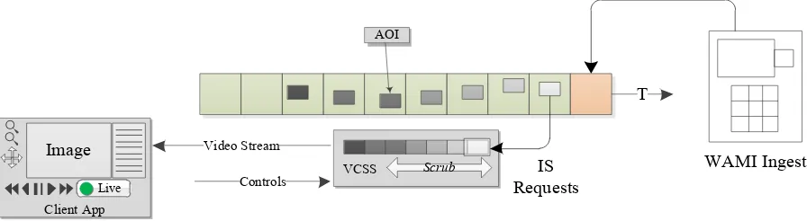
PIXIA Corp is developing a Video Control and Streaming Service (VCSS) specification. VCSS employs
HTTP to control what is displayed in channels of video streams. A client sends commands such as pan,
zoom, and play real-time, faster, slower, jump to
live
, change settings, etc. A server updates AOIs in time
and space. The related video stream reflects it. The feed is a “postage stamp view” over a large area.
Video could be UHD, HD or less, based on connection capabilities. The video may be 30 Hz, but the
pictures in the video may update at a client controlled rate or at the acquisition rate, depending on whether
you are playing from the “
archive
” or “
live
”. VCSS does not control a sensor or its platform.
Client App
VCSS WAMI Ingest
AOI
T
Scrub
Live
Video Stream Image
Controls
IS Requests
Figure 7: Example VCSS pipeline
9.3.3
Virtual File System
While SOA caters to today’s internet model, file access is still common. Tools require image and video
files, and XML. Vendors may not have time to implement HTTP services. They may have to support
legacy client tools that are many years old, and have been adapted to suite immediate WAMI needs. If a
file-based WAMI service was available, it could assist in a phased migration to web services.
9.3.3.1
Avoid vendor lockdown
WAMI sensors and vendors can store and manage data the way they seem fit. If WAMI data is ingested
into a system by one vendor how can a customer switch to another vendor? If a vendor presents WAMI
data over HTTP as files, migration is as trivial as initiating a copy from one vendor to another.
OGC 12-077r1
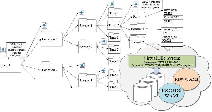
XML(s) with data about files in this folder: KML, GML...
Virtual File System
Implements HTTP 1.1 WebDAV
For read-only: OPTIONS, HEAD, PROPFIND, and GET are required.
Figure 8: Virtual file system using HTTP 1.1 WebDAV
9.3.3.2
HTTP 1.1 WebDAV
After extensive research, we found that HTTP 1.1 WebDAV (RFC 2518) with read-only capability is
sufficient. Implementing HEAD, OPTIONS, PROPFIND and GET is adequate. Presenting WAMI data as
a sequence of files in a customer supported format is critical for:
1.
Avoiding vendor lockdown
2.
Vendor to vendor migration
3.
Providing a transitional solution for file-based tools
A vendor can also virtualize a WebDAV implementation by presenting WAMI data in multiple layouts
via a Virtual File System (VFS).The folder structure in Figure 8is just an example. A folder layout may
be vendor specific. It is prudent to have XMLs (or JSONs) at each folder’s level with relevant. VFS
folders, files and XMLs don’t really exist. A VFS makes you believe they do and presents a file system
experience over secure HTTP. WebDAV clients ship free with Windows, Linux and Mac.
WAMI Service
About
Query Service (QS)
QS filters one or more CS. It’s a search engine over a set of CS. See
NoSQL HTTP APIs by Google, Amazon, Oracle, etc.
Video Control and
Streaming Service (VCSS)
VCSS provides DVR-like controls over HTTP with the video stream
itself coming over a “channel” which could be streams of UDP or TCP.
Virtual File System (VFS)
OGC 12-077r1
10
OGC 12-032r2describes CS, IS and VS
OGC 12-032r2 presents Collection, Image and Video Services. All other services have not been presented
in that document. Further work is warranted and community participation is requested using an OGC
SWG on WAMI. PIXIA has offered to start it.
11
Common model
The following section covers aspects common to all WAMI services.
11.1
RESTful HTTP
The term RESTful HTTP is used to represent a stateless HTTP request/response model, a client and
server processing one independent HTTP request at a time. WAMI services use a RESTful architecture.
11.1.1
HTTP request
The general model of the grammar is derived from OGC. All services support HTTP GET and POST.
Details are in the main document and most readers familiar with OGC specification already know all of
this in great detail. If a request is short (about 2KB), use GET; whereas a POST permits unbounded
multi-valued input parameter sequences, i.e. really long requests.
A GET request is of the general form
http://host[:port]/path[?querystring]
.
A
querystring
is a KVP
2set of the form:
name=value[&name=value]
.Example:
http://example.com/IS?Service=IS&Version=1.0.2&Format=text/xml&Request
=GetCapabilities.
A POST request:
http://host[:port]/path
. The body of a POST
request contains the KVP or
name=value
pair encoding. For
name=value
pairs,
name
is not case
sensitive and is of the form
part[.part]
. For example,
VERSION=1.0.2
and
Version=1.0.2
are valid and
name
can be
options.mpeg2.codec
or
Request
.
11.1.2
HTTP response
The layout of an HTTP response is standardized based on the request type. Exception reporting is drawn
directly from OGC. Each request has a corresponding section on response schema in OGC 12-032r2.
11.2
Required parameters
As with OGC services, all WAMI requests require SERVICE, REQUEST and VERSION.
1.
SERVICE identifies a CS, IS, VS, RS, etc.E.g.
Service=CS
2.
REQUEST identifies the operation to be performed. E.g.
Request=GetMap
3.
VERSION identifies the WAMI specification version a client wants to use. E.g.
Version=1.0.2
11.3
Common WAMI requests
GetCapabilities
and
GetHelp
are common to all WAMI services. The mandatory
GetCapabilities
request informs a client about all the requests the server supports and how.
GetHelp
is optional and
allows vendor to deliver customer support documentation. WAMI GetCapabilities for all services is
summarized in Appendix A. See examples in Appendix B.
2 KVP – Key Value Pair or name-value pair such as
OGC 12-077r1
12
Time
Time value or range is set by the TIME parameter as absolute frame numbers or as ISO time. Frame
based access is efficient, TIME based access is flexible. Both forms of
time
are explicit and do not leave
room for ambiguity. The tables below have been captured from the original document to summarize the
syntax. A client can ask for image data or metadata:
1.
At a single instant in time
2.
Within a window in time, with controlled increments
3.
Within multiple windows in time, with controlled increments for each time window
12.1
Time value KVP syntax
KVP Syntax Meaning Interpretation
value A single time value of as frame number or instant of time of acquisition
Get one map at this time value
value1,value2,value3… A list of explicit multiple values Get multiple maps, each at the specified time
value
min/max/resolution An interval defined by its lower and upper bounds and its resolution. Lower and upper bounds are time values.
Get multiple maps, starting from min, up to and including max, in steps of resolution.
min1/max1/res1,
min2/max2/res2…
A list of multiple intervals. Repeat the above process for multiple time intervals.
recurring_interval/ value/resolution
An interval defined by a recurring time interval designator, interval start time value and its resolution.
Get a total of recurring_interval maps, starting from the time value, and increment time value by resolution for each consecutive map.
int1/value1/res1,
int2/value2/res2…
A list of multiple intervals. Repeat the above process for multiple time intervals.
recurring_interval/ min/max
An interval defined by a recurring time interval designator, and by its lower and upper bounds (time values).
Get a total of recurring_interval maps, starting from time value min, up to and including time value max, dispersed evenly from min to max.
int1/min1/max1,
int2/min2/max2…
A list of multiple intervals. Repeat the above process for multiple time intervals.
12.2
Frame basedTIME
Syntax Interpretation
F[FRAME] Get one map from frame number FRAME.
F[START]/F[END]/FS[STEP] Get multiple maps from frame number START, up to and including frame number END, incrementing the frame number from START in steps of STEP. To go backward, set END < START. STEP ≠ 0.
R[N]/F[START]/FS[STEP] Get N frames starting from START, increasing each subsequent frame by STEP. STEP is an integer. STEP < 0, go backward. STEP > 0, go forward. STEP ≠ 0.
R[N]/F[START]/F[END] Get a total of N frames, starting from frame START and ending at frame END. To go backwards, set END < START. N > 0.
Frame based time is efficient. It directly maps to required data. ISO time of acquisition (TOA) requires
mapping the time to an absolute frame. Client’s ISO time map 1:1 with a frame’s TOA. If it does not, any
ambiguity is resolved as specified in the “
Temporal mismatch
” section below.
Example KVP Requests Meaning
Time=F100 One map of frame number 11 from a collection
Time=F100/F2629 From frame 100 to 2629; expect 2530 maps
OGC 12-077r1
Time=F200/F100/FS2 From frame 200 to 100 (backward); in increments of 2; expect 51 maps
Time=R10/F200/FS2 From 200; in increments of 2; expect 10 maps from 200, 202 … 216, and 218.
Time=R10/F200 Expect 10 maps, from frame 200 up to and including 209.
Time=R10/F200/FS-2 From 200; in decrements of 2; expect 10 maps from 200, 198, 196 …184, and 182.
Time=F1,F11,F21,F31,F41 Expect 5 maps from frames 1, 11, 21, 31 and 41 in that order.
Time=F1/F11,F21/F31,F34/F44 Expect 33 maps from 1 to 11, followed by 21 to 31, followed by 34 to 44.
Time=F1/F11/FS2,F21/F31/FS3 ,F34/F44/FS2
Frames 1 to 11 in steps of 2; frames 21 to 31 in steps of 3; frames 34 to 44 in steps of 2; expect 16 maps.
12.3
ISO time based TIME
TIME parameter value is also based on ISO 8601.It is best illustrated by way of examples.
Example KVP Requests Meaning
Time=2008-08-20T15:04:26.772Z Retrieve one map with the specified time of acquisition (TOA)
Time=2008-08-20T15:04:26.772Z/2008-08-20T15:29:35.9733Z
Retrieve all maps between the specified interval(s).
Time=2008-08-20T15:04:26.772Z/2009-08-20T15:29:35.9733Z/P3D
Retrieve all maps between specified interval(s), with each map from the 2008 date to the 2009 date at a 3 day intervals.
Time=2008-08-20T15:04:26.772Z/2009-08-20T15:29:35.9733Z/P1M15D
Retrieve all maps between specified interval(s), with each map from the 2008 date tothe 2009 date at a 1 month and 15 day interval.
Time=2008-08-20T15:04:26.772Z/2009-08-20T15:29:35.9733Z/P1M, 2010-08-
20T15:04:26.7702Z/2011-08-20T15:29:35.9733Z/P1D
Retrieve all maps within two separate intervals (playlist), the first range is at a month’s interval per frame and the second range is at a day’s interval per frame.
Time=2008-08-20T15:04:26.772Z/2008-08-20T15:29:35.9733Z/PT1.5S
Retrieve all maps between the specified ranges, with every map from the 2008 date until the 2009 date at a 1.5 second intervals.
Time=R100/2008-08-20T15:04:26.772Z Retrieve 100 consecutive maps starting from the 2008 date and time, moving forward in time, at an interval that is the same as the capture rate of each consecutive frame in that collection.
Time=R100/2008-08-20T15:04:26.772Z/PT1.5S
Retrieve 100 consecutive maps starting from the 2008 date and time, moving forward in time, with each subsequent map at increments of 1.5 seconds.
Time=R60/2008-08-20T15:04:01Z/2008-08-20T15:04:90Z
Retrieve 60 consecutive maps starting from the 2008 date,from 15:04:01 until 15:04:90 UTC, moving forward in time. Based on the request for 60 consecutive maps, the period computes to about PT1.509S.
13
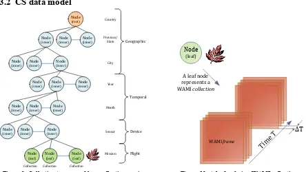
Collection Service
The Collection Service or CS allows a client to discover what collections of WAMI data are being served
by a service implementation. See examples in Appendix B.
13.1
Definition of a WAMI data
Collection
OGC 12-077r1
(inner) (inner)Node (inner)Node
Node
(inner) (inner)Node (inner)Node
Node
(inner) (inner)Node
Geographic
Node
(inner) (inner)Node (inner)Node
Node
(inner) (inner)Node (inner)Node
Node
(leaf) Node(leaf) Node(leaf)
Temporal
Figure 9: Collection tree served by a collection service
WAMI frame
Figure 10: A leaf node is a WAMI collection
CS draws its structure heavily from the industry as well as multiple OGC specifications of presenting the
organization of a set of maps, metadata, raster data, vector data, and video. Hierarchical data is generally
presented in the form of an inverted tree structure. In computer science a tree is a widely-used data
structure that emulates a hierarchical tree structure with a set of linked nodes. For the purpose of this
specification, a
Collection Tree
is a data structure that is an
ordered directed tree
, more specifically
arborescence
: a connected acyclic graph where each node has zero or more
children
nodes and at most
one
parent
node. Furthermore, the children of each node have a specific order.
A node is a structure which may contain a value, a condition or represent a separate data structure. A
childnode
is hierarchically below a node and a node that has a child is the
parentnode
of that child. Nodes
without children are
leaf nodes
or
terminal nodes
. Nodes with children are also known as
inner nodes
.
The first node of the tree has zero parent nodes and is the
root node
. A connection between nodes is
called an
edge
or a
link
. The path from the root node to any node is unique and may be traversed through
the links. Each collection (as defined above), is unique from all other collections.
In the figure, you can also see a possible organizational structure that may get used practically.
13.3
Summary of all requests
Request Meaning Parameters Optionality
GetCapabilities Allows the client to retrieve metadata about the capabilities of the CS service implementation
GetHelp Allows the client to retrieve help on topics provided by the server
Service, Request, Version, Topic, Format
Optional
GetCollectionCount Retrieves the number of collections being served by the server
Service, Request, Version, Format, AcceptLanguages, NID, Depth, CRS, Bbox, Time
OGC 12-077r1
GetCollections Retrieves the set of collections being served by the server. Result is as a tree.Incremental node by node traversal is available from any tree node. Complete or partial collection metadata can be retrieved.
Service, Request, Version, Format, NID, Metadata, Depth, CRS, Bbox, Time
Mandatory
14
Image Service
As an image and metadata flipbook service, the Image Service or IS delivers a view into WAMI
collections. It delivers derived content as maps and metadata from the original camera-space data or from
data that is already available in a derived content space. See examples in Appendix B.
14.1
Summary of all requests
Request Meaning Parameters Optionality
GetCapabilities Allows the client to retrieve metadata about the capabilities of the IS server implementation
Service, Request, Sections, AcceptVersions,
AcceptFormats, AcceptLanguages, UpdateSequence
Mandatory
GetHelp Allows the client to retrieve help on topics provided by the server
Service, Request, Version, Topic, Format
Optional
GetMap Retrieves an area of interest from one or more frames from one or more collections of WAMI data as one or more images or interleaved images & metadata, in standard formats. See Appendix A for a summary.
Service, Request, Version, Format, AcceptLanguages, Disposition, CID, CRS, BBox, Width, Height, Styles, Transparent, Bgcolor, Time, Metadata, Options
Mandatory
GetMapInfo The request is similar to GetMap except it retrieves metadata only.
Service, Request, Version, Format, AcceptLanguages, CID, CRS, BBox, Width, Height, Time, Metadata, Options
Optional
GetPathMap Retrieves areas of interest (AOIs) from one or more collections of WAMI data as one or more images or images + metadata, in supported standard formats. The data for collection, time periods and bounding AOIs is supplied as a path3.
Service, Request, Version, Format, AcceptLanguages , Disposition, CRS , Width, Height, Styles,
Transparent, Bgcolor , Metadata, Options, Path
Optional
GetPathMapInfo The request is similar to the GetPathMap request except that instead of images + metadata it retrieves metadata only.
Service, Request, Version, Format, AcceptLanguages, CRS, Width, Height, Metadata, Options, Path
Optional
3 A path is defined as a one or more tracks, each track has a set of key frames and a track evaluation method. The
OGC 12-077r1
15
Video Service
The Video Service is notionally identical to the IS. Instead of a flipbook of images, it delivers a video clip
of those images. If the content format supports the addition of metadata, it is included. See B.4 VS in
Appendix B.
15.1
Summary of all requests
Request Meaning Parameters Optionality
GetCapabilities Allows the client to retrieve metadata about the capabilities of the IS server implementation
Service, Request,
Sections, AcceptVersions, AcceptFormats,
AcceptLanguages, UpdateSequence
Mandatory
GetHelp Allows the client to retrieve help on topics provided by the server
Service, Request, Version, Topic, Format
Optional
GetMapVideo Retrieves an area of interest from a sequence of frames from one or more collections of WAMI data as one video stream or video file in a supported standard format. See Appendix A for a summary.
Service, Request, Version, Format, CID, CRS, BBox, Width, Height, Styles, Transparent, Bgcolor, Time, Dup, Metadata, Options
Mandatory
GetPathMapVideo Retrieves an area of interest from a sequence of frames from one or more collections of WAMI data as one video stream or video file in a supported standard format. The information about the collection, time periods and bounding AOIs is supplied as a path.
Service, Request, Version, Format, CRS, Width, Height, Styles, Transparent, Bgcolor, Dup, Metadata, Method, Options, Path
Optional
16
Considerations
In case of ambiguity, a consistent outcome is required. A few use cases have been described below.
16.1
High latency networks
For high latency networks, it is better to get as much data with as few requests. When using an IS
flipbook, performance degrades if each frame is a separate request. If a client buffers 10 frames at a time,
using a single request, the client can request those frames using TIME (TIME=F1/F10/FS1). For low
speed networks, request a video stream.
16.2
Temporal mismatch
OGC 12-077r1
Figure 11: Consistently resolve temporal ambiguity
16.3
Spatiotemporal overlap
In WMS, when overlapping multiple layers, the issue of sub-pixel overlap is common. Servers choose to
round off to pixel boundaries and avoid compositing complexity. Servers round off to the lowest, highest
or closest pixel. In either case, the error is consistent.
This choice avoids rendering artifacts and increases performance for the price of sub-pixel accuracy when
overlapping maps. A similar choice has to be made when thinking of all dimensions simultaneously – X,
Y, zoom and T. The choice is open to the server implementation so long as it is consistent.
16.4
Rendering maps along a pre-defined path
The requests
GetPathMap
and
GetPathMapVideo
draw heavily from the animation industry. A client
describes a
path
. A
path
has one or more
tracks
. A
track
defines a curve with
entries
. Each
entry
is a
key-frame
. The key-frame specifies a bounding box and time within a set of collections. The rendering
system on the server side first interpolates all points in-between the key frames to generate all points for
all frames within the “clip”.
Collection
Figure 12: Consistently resolve spatiotemporal ambiguity
Collection
OGC 12-077r1
Time = T1 + 10s Time = T1 + 8s
Time = T1 + 3s Time = T1
Example: Original WAMI data has 20 frames captured at 2 FPS, at times T1, T1+0.5s, T1+1s,
T1+1.5s… until T1+19.5s. Rendering uses Catmull‐Rom spline interpolation
6 map images Smooth movement Feels like zooming‐ out while panning
10 map images Smooth movement Feels like zooming‐ in while panning
4 map images Smooth movement Feels like a fast pan 1280
720
20, 1280 x 720 map images rendered using four key AOIs
Figure 14: Key-frame animation using GetPathMap and GetPathMapVideo
This is analogous to
in-betweening
in
key-frame animation
. Once points for all frames are generated
(which is very fast), each point for each frame is merely a
GetMap
request. As each frame gets rendered
it is returned to the consumer as part of a flipbook or video codestream. One request results in many
frames, helping cater to networks with high latency.
16.5
Tile server
The metadata returned by a CS implementation can describe the ideal layout of a WAMI collection in
terms of tiles of original map and R-sets, informing the client on an optimal way to request data. Each
collection’s CS metadata would provide image dimensions, number of R-sets, scale factor of each R-set,
tile row and column count, tile dimensions, etc. The client could then make IS: GetMap requests on tile
boundaries. Tile playback synchronization would be a client-side issue to tackle.
Original
R1
R2 R3
Original
R1
R2 R3 Original
R1
R2 R3 Original
R1
R2 R3
Time
AOI
AOI
AOI
OGC 12-077r1
17
Conclusion
WAMI is a big data problem. OGC 12-032r2 is critical to effectively utilizing WAMI data in the
www.For further questions, please contact the authors, preferably through the OGC. We welcome
feedback and support to help make a commercially successful implementation of a global best practice.
Appendix A: Requests summarized
A.1 GetCapabilities
All services shall implement the GetCapabilities request. It tells the client what a service delivers.
Parameter name KVP Example Optionality/ multiplicity
Definition, format and use
Service Service=CS Mandatory,
one
Abbreviated service identifier text. Shall be implemented by both client and server.
Request Request=
GetCapabiliti es
Mandatory, one
Operation name text. Shall be implemented by both client and server.
AcceptVersions AcceptVersion
Prioritized sequence of one or more specification versions that the client accepts, with preferred versions listed first. When omitted, return the latest supported version. Should be implemented by clients. Shall be implemented by servers.
Sections Sections=
Contents
Optional, zero or one
Comma-separated un-ordered list of zero or more names of sections of service metadata document to be returned in service metadata document. May be implemented by client and server. If not
implemented, expect/provide default response. UpdateSequence UpdateSequenc
Service metadata document version, value is “increased” whenever any change is made in complete service metadata document. May be implemented by client and server. If not implemented, expect/provide default response.
AcceptFormats AcceptFormats
Prioritized sequence of zero or more response formats desired by client, with preferred formats listed first. When omitted or not supported by server, return response using MIME type application/xml. May be implemented by client and server. If not implemented, expect/provide default response.
AcceptLanguages AcceptLanguag es=en-US
Optional, zero or one
OGC 12-077r1
A.2 GetHelp
This request is optional.
Parameter name KVP Example Optionality / multiplicity
Definition, format and use
Service Service=CS Mandatory,
one
Abbreviated service identifier text. Shall be implemented by both client and server.
Request Request=
GetHelp
Mandatory, one
Operation name text. Shall be implemented by both client and server.
Version Version=1.0.2 Mandatory,
one
Version number of service. Shall be implemented by both client and server
Format Format=
application/x ml
Optional, zero or one
MIME type of the format in which the server shall provide the response. A list of supported MIME types shall be made available in the Capabilities response under the Operation XML element. The default format shall also be specified in the corresponding Capabilities response.
Exceptions Exceptions=XM
L
Optional, zero or one
Sets the format of the exception.
Topic Topic=
Specification s
Optional, zero or one
Name of a help topic. A list of supported help topics shall be made available in the Capabilities response. This parameter shall specify a topic that the client chooses to request help on. The server shall support sending a valid response to all values it lists as allowed values to this parameter. The default format shall also be specified in the corresponding
Capabilities response. AcceptLanguages AcceptLanguag
es=en-US
Optional, zero or one
List of languages desired by the client for all human readable text in the response, in order of preference. For every element, the first matching language available from the server shall be present in the response. When not supported by server, return human readable text in a language of the server’s choice. Shall be implemented by multi-lingual servers and clients.
A.3 CS:GetCollectionCount
Parameter name
KVP
Example Optionality/ multiplicityDefinition, format and use
Service Service=CS Mandatory,
one
The value for this parameter shall be CS.
Request Request=
GetCollectionCount Mandatory, one The value for this parameter shall be GetCollectionCount.
Version Version=1.0.2 Mandatory,
one
Version number of service. Shall be implemented by both client and server
Format Format=application/
xml Optional, zero or one Please refer to [WAMI OVERVIEW]
AcceptLanguages
AcceptLanguages=en-US Optional, zero or one Please refer to [WAMI OVERVIEW]
NID NID=Unique1234 Optional,
zero or one
OGC 12-077r1
If not set or empty, implies root node. Shall be implemented by both client and server.
Depth Depth=All Optional,
zero or one
Specifies how deep the collection counter shall go down the tree. It has two possible values: 1 or All. If not set or empty, implies Depth=All. The parameter shall be implemented by both client and server.
1: Client receives number of child nodes under root or specified node.
All: Client receives all the node counts below specified node.
Bbox Bbox=minx,miny,maxx
,maxy Optional, zero or one Bbox specifies a bounding box in the reference system set by CRS. The request filters selected
nodes in the tree through this bounding box. The parameter shall be implemented by both client and server. This parameter is optional. The default value is “unbounded” to include all collections. If Bbox is set, CRS shall be set. Setting Bbox without CRS, or setting CRS without Bbox indicates error.
CRS CRS=epsg:4326 Optional,
zero or one
See Bbox.
Time Time=T1/T2,T3/T4,T5 Optional,
zero or one
Specifies one or more time values or time ranges. The request filters selected nodes in the tree through the time values and ranges. The parameter shall be implemented by both client and server. This parameter is optional. The default value is all time. Time is set in ISO 8601:2004 format (not as frame numbers).
A.4 CS:GetCollections
Parameter name
KVP
Example Optionality / multiplicityDefinition, format and use
Service Service=CS Mandatory,
one
The value for this parameter shall be CS.
Request Request=
GetCollections Mandatory, one The value for this parameter shall be GetCollections.
Version Version=1.0.2 Mandatory,
one
Version number of service. Shall be implemented by both client and server
Format Format=applicati
on/xml Optional, zero
or one
Please refer to [WAMI OVERVIEW]
AcceptLanguages AcceptLanguages=
en-US Optional, zero
or one
Please refer to [WAMI OVERVIEW]
NID
NID=”unique-1234” Optional, zero or one Specifies the node identifier to retrieve. It shall be a value string that is unique to the tree. If this
parameter is not specified or left empty, it means the root node. Shall be implemented by both client and server.
Depth Depth=1 Optional, zero
or one
This parameter shall have only three possible values: 0, 1 and All. The default value shall be
Depth=0. Shall be implemented by both client and server.
0: only send information about this node.
OGC 12-077r1
immediate children.
All: send information about this node and all nodes under it.
Metadata Metadata=All Optional, zero
or one
A comma-separated ordered list of zero or more names of sections of metadata to be returned. If not set or empty, it means do not send metadata with node information. If set to All, it means send all metadata with node information. At least the value of All shall be implemented. A complete list shall be provided as part of the Capabilities response to the GetCollections request. Shall be implemented by both client and server.
Bbox Bbox=minx,miny,m
axx,maxy Optional, zero
or one
Same as GetCollectionCount
CRS CRS=epsg:4326 Optional, zero
or one
Same as GetCollectionCount
Time Time=T1/T2,T3/T4
,T5 Optional, zero or one Same as GetCollectionCount
A.5IS:GetMap
Parameter name
KVP Example Optionality / multiplicity
Definition, format and use
Service Service=IS Mandatory, one The value shall be IS Request Request=GetMap Mandatory, one The value shall be GetMap
Version Version=1.0.2 Mandatory, one Version number of service. Shall be implemented by both client and server.
Accept Languages
AcceptLanguages =en-US
Optional, zero or one
Please refer to [WAMI OVERVIEW]
Exceptions Exceptions=XML Optional, zero or one
Sets the format of the exception.
Format Format=
image/jpeg
Mandatory, one Image output encoding. Note that if multiple images are selected, or if metadata is requested, then the Disposition parameter must also be specified (to avoid accidental unexpected result contents). In doing so, the response Content-Type shall be one of multipart/related or multipart/x-mixed-replace; depending on the value of Disposition. Disposition Disposition=ord
ered
Optional, zero or one
This field is required if Metadata is requested or if multiple images are requested (via specifying a Time Range). Valid values are “ordered”, “unordered”, “replace”. Servers that support multipart responses MUST implement “ordered”. The “unordered” and “replace” values are optional both for client and server.
OGC 12-077r1
CRS CRS=EPSG:4326 Mandatory, one The coordinate reference system of the requested map. Shall be implemented by both client and server.
BBox BBOX=10.0,10.0,
10.1,10.1
Mandatory, one The bounding box of the map in the specified CRS. General model: Bbox=minx,miny,maxx,maxy. Shall be implemented by both client and server.
Time Time=F234/F345/
FS1
Mandatory, one or more
ISO 8601 time-range (in UTC time) or absolute frame-number range and optional step value. Shall be implemented by both client and server. For implementation purposes, if the first character is ‘F’, then it is a frame or frame-range based request. Otherwise it must comply with ISO 8601 time or time-range. For the frame-range the format is ‘F’ \d+ ( ‘/F’ \d+ ( ‘/FS’ \d+ )? )?
Width Width=512 Mandatory, one Width in pixels of the output map pictures. Shall be implemented by both client and server.
Height Height=512 Mandatory, one Height in pixels of the output map pictures. Shall be implemented by both client and server.
Styles Styles= Mandatory, one Comma-separated list of one rendering style per requested collection. An empty list implies default styles. Shall be implemented by both client and server.
Transparent Transparent=TRU E
Optional, zero or one
Background transparency of the maps (Default: Transparent=FALSE). Shall be implemented by both client and server.
Bgcolor Bgcolor=0x00000
0
Optional, zero or one
Hexadecimal red-green-blue color value for the background color. (Default: Bgcolor=0x000000). Shall be implemented by both client and server.
Metadata Metadata=Basic,
Sensor,Platform
Optional, zero or one
A comma-separated ordered list of zero or more names of sections of metadata to be returned. If not set or empty, it means do not send metadata with image data. Shall be optionally implemented by both client and server. When specified, the Disposition parameter needs to be set to allow multipart documents.
Optional, zero or more
Vendor specific options for this request. Extends the request with one or more vendor defined parameter names. The format of all parameter names will be of the form