36 April 2010 | GEOconnexion InternationalMagazine
ADAM THOMAS (FUGRO NPA LIMITED),
CHRIS MEIKLE & DAVID SHILSTON (ATKINS
LIMITED) EXPLAIN HOW SATELLITE IMAGERY
IS BEING USED TO BETTER UNDERSTAND
THE GEOLOGICAL, ENVIRONMENTAL AND
DEMOGRAPHIC IMPACT OF THE LUSI MUD
VOLCANO, JAVA, INDONESIA.
REMOTE MONITORING
OF A MUD VOLCANO
The colloquially named ‘LUSI’ mud volcano (Lumpur - Sidoarjo) began erupting on the 29thMay 2006, during the drilling of an
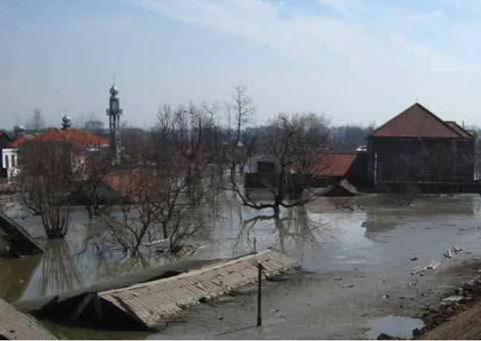
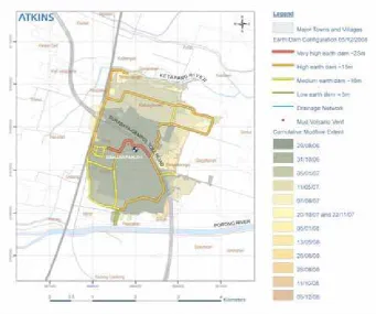
exploratory gas well in the Porong District of Java, Indonesia. Over the last 3 ½ years, the continuous flow of hot toxic mud from LUSI has reached rates of between 100,000 and 160,000 cubic metres per day and has inundated an area of about 6.4 square kilometres, despite attempts by the local authorities to retain the flow with the construction of large earth dams (Figures 1 & 2).
The eruption has resulted in thirteen deaths and the displace-ment of more than 30,000 people. The mud flow has inundated houses, factories, farmland and the Surabaya-Gempol Toll Road. It has placed at risk a railway line, the surface water drainage and irrigation network, ecosystems, water and gas pipelines, and fibre-optic cables connecting Surabaya to Eastern Indonesia.
The ongoing physical, economic and political effects of LUSI’s eruption have been widely documented in newspapers, on the internet and in academic journals. However the origin of the LUSI mud volcano is the subject of considerable controversy, with two competing hypotheses. The first proposes that the eruption was the result of an underground blowout caused by the drilling of an exploratory gas well [1]. The second suggests it was triggered by an earthquake two days earlier, 300 kilometres west of Porong, which re-activated a local fault system, which in turn acted as conduit for the mud [2].
In the period shortly after LUSI’s initial eruption, there was considerable concern within the local community. People wanted to know what impact the erupting mud was going to have, how long it would last and what mitigating measures would be implemented. MAIN IMAGE FIGURE 1: The construction of large
www.geoconnexion.com 37
HAZARD MONITORING
At the time of Atkins’ initial site visit in May 2007 LUSI had been erupting for 1 year and best estimates of the longevity were that it would continue to erupt for decades. Judgements about LUSI’s behaviour and the risk posed local property, industry and businesses in the months and years to come were necessarily tentative. It was concluded that a programme of hazard monitoring using satellite remote sensing would best meet the requirements for regularly updating the initial risk assessment.
Satellite mapping specialists Fugro NPA helped Atkins design and implement a remote hazard monitoring programme on behalf of Atkins’ client. The programme made use of two types of satellite mapping, interpretation of VHR (Very High Resolution) optical imagery to assess the evolution of mud inundation, and InSAR (Interferometric Synthetic Aperture Radar) to assess ground stability. The imagery was procured and processed by Fugro NPA and further analysed by specialists at Atkins.
Mud FLOW EVOLUTION
The physical consequences of LUSI have been observed and recorded using regularly acquired VHR optical images from the IKONOS and Quickbird satellites (Figure 3). Comparisons made between images taken every 1 to 3 months have enabled good assessments to be made. During analysis of the VHR optical imagery, attention was paid to the distribution of mudflows from the vent, the construction and performance of the earth dams, changes in behaviour of the nearby rivers, changes in land use, distribu-tion of surface water flooding, and lateral migration of the mud volcano vent. All observed data were recorded within a geo-database (Figure 4).
GROUND STABILITY
In addition to the surface changes due to
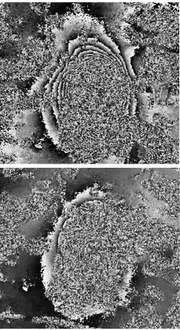
mud inundation, ground subsidence due to withdrawal of material from subsurface levels was a key concern. Further to the effects of such subsidence on the local environment and infrastructure, the location and magnitude of the subsidence signals also gives valuable information about the subsurface structure and dynamics of the mud volcano, essential to understanding the ongoing risks. Fugro NPA utilised an InSAR processing technique known as Differential InSAR (DifSAR) to detect wide area ground deformation across the mud volcano and the surrounding area.
DifSAR employs two Synthetic Aperture Radar (SAR) images, spanning a specific timeframe, and through complex radar processing derives topographic height change (i.e. ground deformation) informa-tion. The combination of largely agricultural land use and the large amount of ground
movement observed and predicted across the area of interest would result in poor SAR signal coherence in conventional C-band (5.6 cm wavelength) data. The longer 23.6 cm wavelength of L-band SAR data increases coherence in vegetated areas, and enables measurement of larger magnitude deforma-tion signals over relatively short timeframes.
ALOS PALSAR is an L-band instrument operated by JAXA (Japanese Aerospace Exploration Agency). Fugro NPA acquired a sequence of ALOS PALSAR images at approx-imately 6-month intervals, starting from 19th May 2006 (pre-eruption). Figure 5 shows two DifSAR results produced during the monitoring programme; in each case the mud volcano can be seen as an approxi-mately rectangular area of incoherence (noise) surrounded by between 17cm and 108cm of line-of-sight subsidence (depicted by the number of black-to-white contours).
FIGURE 2.The impact of mud inundation. Note the depth of mud in relation to the building roof adjacent to the earth dam. Photograph taken 29th May 2007. © Atkins Ltd. 2007.
38 April 2010 | GEOconnexion InternationalMagazine
MODELLING
The DifSAR results enabled Atkins to construct three-dimensional models of the ground surface deformation associated with LUSI. This revealed a primary area of subsidence surrounding the mudflow extent; this is most severe near the vent, where it is difficult to monitor due to loss of coherence over the constantly changing
mudflow. Deformation magnitude was highest in the period spanning the start of the eruption, however noticeable deformation has occurred in subsequent interferograms, indicating ongoing subsidence of the area.
AN UNCLEAR FUTURE
Since its initiation on 29th May 2006, LUSI’s eruption has had, and continues to have, a serious effect on the Porong District of Eastern Java; and there are no signs that the mud flow is decreasing. The flow of mud and ground surface deformation has had an impact on the physical, environmental, economical and social aspects of local and regional communities. The remaining lifespan of LUSI’s eruption is still not known, but best estimates are that it will continue to erupt for decades and not just a few years.
The sequence of DifSAR results produced during the hazard monitoring programme are an excellent demonstration of the capabilities of the L-band ALOS PALSAR sensor. The results, derived remotely and at a compara-tively low cost, have given the team and their client a unique insight into the evolution of ground surface deformation across the mud volcano, even with variable levels of coherence across the site.
For now, a continued programme of regular remote monitoring of the mud flow extent and ground surface deformation, such as the one designed and implemented by the team, will provide a valuable resource for updating geohazard and risk assessments, aiding the management of the mud volcano and its impact info the future.
FIGURE 4: An extract from the geo-database (05/12/2008) used to record the physical changes associated with the LUSI mud volcano. Image © Atkins Ltd. 2009.
DATA SOFTWARE HARDWARE APPLICATIONS
Cartographic Surveying Large Format Printers & Plotters Environmental/Natural Resources Accuracy Cartographic Production PC/Workstation Technology Health
Metadata Visualisation Hand-Held Devices for Personal Nav. Public Safety Remotely Sensed WebMapping Speech Reocog. & Voice Output Tech. Retail Warehousing Image Processing / Compression Analogue & Digital Airborne Cameras Environmental Capture/Conversion Spatial Databases Laser Range Finders Utilities Legislation and Privacy Issues Digital Photogrammetry GPS/GIS Data Capture Surveying Standards / Availability Cadastre/LIS Photogrammetric Workstations Location-Based Services Web & Wireless Content 3-D Modelling Bulk Data Storage Transport and Logistics Data Integration Geomarketing Wireless Technology Telecommunications Offshore Services Addressing and Geocoding Surveying Instruments Geophysics
www.geoconnexion.com/subscription or email: [email protected]
The latest news in one location
www.geoconnexion.com 39
REFERENCES
1. Davies, R. J., Swarbrick, R. E., Evans, R. J. and Huuse, M. 2007. Birth of a Mud Volcano: East Java, 29 May 2006, GSA Today, v.17, no. 2, 4-9.
2. Mazzini, A., Svensen, H., Akhmanov, G.G., Alonsi, G., Planke, S., Malthe-Sørens, A., and Istadi, B. 2007. Triggering and dynamic evolution of the LUSI mud volcano, Indonesia. Earth and Planetary Science Letters, v. 261, 375-388.
Adam Thomas is a Project Manager within Fugro NPA’s InSAR Surveying Department. Chris Meikle and David Shilston are Engineering Geologists at Atkins. For further information please contact the authors:
Email: [email protected] Telephone: +44(0)1732 865023 Website: www.fugro-npa.com
Email: [email protected] Telephone: +44(0)1372 754409 Website: www.atkinsglobal.com