Journal of Geological
Resource and Engineering
Volume 4, Number 2, February 2016 (Serial Number 11)David
David Publishing Company www.davidpublisher.com
Publishing
Publication Information:
Journal of Geological Resource and Engineering is published monthly in hard copy (ISSN 2328-2193) by David Publishing Company located at 616 Corporate Way, Suite 2-4876 Valley Cottage, NY 10989, USA.
Aims and Scope:
Journal of Geological Resource and Engineering, a monthly professional academic journal. Its aim is to achieve the advancement and dissemination of information in the fields of geology, geotechnics, geological engineering, geological resource and so on. And articles interpreting successful policies, programs or cases are also welcome.
Editorial Board Members:
Prof. Barbara, Maria Namysłowska-Wilczyńska (Poland), Prof. Atac Bascetin (Turkey), Prof. Basuony M. El-Garhy (KSA), Dr. Eduardo Antonio Gomes Marques (Brazil), Dr. Ji Whan Ahn (Korea), Dr. Emoke Maria Imre (Hungary), Prof. Mohamed Ismail Ibrahim (Egypt), Dr. Giovanna Vessia (Italy), Prof. Luís Carlos Loures (Portugal), Prof. Kanaan Hussein Moussa (Lebanon), Dr. Joshua Ramogi Omer (UK), Prof. Andrea Brogi (Italy), Prof. Yousef Habous Nazzal (UAE), Prof. Vlado Gicev (Macedonia), Dr. Behshad Jodeiri Shokri (Iran), Dr. A. K. M. Khorshed Alam (Bangladesh), Prof. Lee W. Clapp (USA), Prof. Hongfei Cheng (China),
Prof. Mossbah M. Kolkas (USA), Dr. Xiaowei Pan (South Africa), Dr. Debdas Ray (India), Dr. Che Abd Rahim Bin Mohamed (Malaysia), Dr. Taoufik Ait-Ettajer (USA), Prof. Vijayan Gurumurthy Iyer (India)
Manuscripts and correspondence are invited for publication. You can submit your papers via web submission, or E-mail to [email protected] or [email protected]. Submission guidelines and web submission system are available at http://www.davidpublisher.com.
Editorial Office:
616 Corporate Way, Suite 2-4876 Valley Cottage, NY 10989, USA
Tel: 1-323-984-7526, 323-410-1082, 607-4416220; Fax: 1-323-984-7374, 323-908-0457 E-mail: [email protected], [email protected]
Copyright©2016 by David Publishing Company and individual contributors. All rights reserved. David Publishing Company holds
the exclusive copyright of all the contents of this journal. In accordance with the international convention, no part of this journal may be reproduced or transmitted by any media or publishing organs (including various websites) without the written permission of the copyright holder. Otherwise, any conduct would be considered as the violation of the copyright. The contents of this journal are available for any citation. However, all the citations should be clearly indicated with the title of this journal, serial number and the name of the author.
Abstracted / Indexed in:
Chinese Database of CEPS, CNKI, China
Chinese Scientific Journals Database, VIP Corporation, Chongqing, China
CiteFactor (USA), Ulrich’s International Periodicals Directory, USA
Google Scholar
Price (per year): Print $520; Online $360; Print and Online $680 David Publishing Company
616 Corporate Way, Suite 2-4876 Valley Cottage, NY 10989, USA
Tel: 1-323-984-7526, 323-410-1082, 607-4416220; Fax: 1-323-984-7374, 323-908-0457 E-mail: [email protected]
David Publishing Company www.davidpublisher.com DAVID PUBLISHING
Journal of
Geological Resource and
Engineering
Volume 4, Number 2, February 2016 (Serial Number 11)
Contents
Theoretical Research
51 Correlation between Tectonic Environment and Chracteristics of Mass Movement (Landslides): A Case Study from Java, Indonesia
Sari Bahagiarti Kusumayudha and Ayu Narwastu Ciptahening
63 New Technologies on Mine Process Tailing Disposal Bascetin A., Tuylu S., Ozdemir O., and Adıguzel D.
73 The Kalahari Impacts Hypothesis for the Birth of the Moon: Did Morokweng Meteorite Impact (145 Ma) Break up the Gondwanaland and Ignite Volcanic Explosion to Form the Moon?
Kumon “Kimiaki” Tokumaru
Techniques and Methods
81 Some Results of Quantitative Analysis of Fracture Orientation Distribution along the Segment Tien Yen-Mui Chua of Cao Bang-Tien Yen Fault Zone, Quang Ninh Province, Viet Nam
Truong Thanh Phi
89 The Ellipsoidal Surface Method Solving by Integration for Slope Stability Analysis Sy Huu Pham, Vinh Phu Pham and Minh Le Vu
Correlation between Tectonic Environment and Chracteristics of Mass Movement (Landslides): A Case Study from Java, Indonesia
Sari Bahagiarti Kusumayudha & Ayu Narwastu Ciptahening
Universitas Pembangunan Nasional “Veteran” Yogyakarta, Indonesia
Abstract: In Central Java and Yogyakarta Special Region, there are several zones, which
potential of landslide disaster. The zones are in general located at uplifted and or folded mountains, such as North Serayu Mountains, South Serayu Mountains, Menoreh Mountains, Southern Mountains and slopes of young volcanic area, including Ungaran-Merbabu-Merapi area, and Slamet-Sundoro-Sumbing area. Besides morphology, another main factor influencing vulnerability of the terrain is physical properties of the composing lithology. The geologic formations in the study area are predominantly composed of clayey and volcanic rocks. The cohesion force of clayey rock ranges 0.4 – 0.7 kg/cm2, the internal friction angle ranges 20o – 35o, while the cohesion force of volcanic rock (weathered) ranges 0.25 – 0.27 kg/cm2, and the friction angle ranges 20o – 35o. In general, rocks occupying the area are collectively dissected by joints and active faults, with soil of more than 5 m thick. Local rainfall belongs to high category (>2500 mm/y). However, landslides that occur in each physiographic zone mentioned above show different characterizations.
Key words: tectonic environment, mass movement characteristic
Introduction
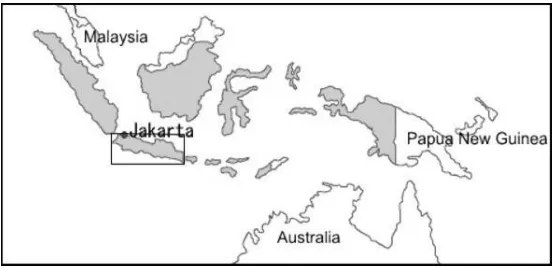
Indonesia is a country consisting of about 17,000 islands, controlled by dynamic tectonic environment, generating it rich of active volcanoes, potential of earthquake, and plenty of uplifted mountainous area. In fact, mountainous areas with their slopes mostly play as the main factor for mass movement occurrence. Fig. 1 shows the study area.
Fig. 1 Indonesia Archipelago and case study area
Objectives of the study are to analyze and develop a model on the influence of tectonic environment and physiographic zones to mass movement characteristics. The study was done based on literatures reviews, assessments and analyses, and field surveying.
Tectonic Environments
Indonesia archipelago is formed by the collision among Eurasian continental plate, India - Australia oceanic plate, and Pacific oceanic plate (Fig2). The implication of the plates meeting in Indonesia is formations of active volcanic chains, folded mountain lines, vigorous faults and tectonic zones.
Fig. 2 Tectonic Setting of Indonesia Archipelago. Red line: plate boundary; blue arrow: plate movement
In the western part of Indonesia, the interaction of Eurasia and India-Australia plates brings about subduction of the oceanic plate beneath the continental plate [3]. In a certain depth, when the environment related to temperature and pressure is condusive, there will be partial melting of the subducted oceanic plate producing magma. Due to diaphiric force and density difference between the magma and surrounding material, the new magma arise to reach earth surface forming active volcanoes. In general the tectonic component of West Indonesia area includes trench, accreted wedge, fore arc basin, volcanic arc, and back arc basin. Figure 3 sows tectonic component of western Indonesia.
In spite of tectonically active, Indonesia has wet Tropical climate with relatively high rain fall, approximately more than 250 mm/year [5], [7]. This condition is very conducive for mass movement occurrence, due to physical factors such as mountainous areas with steep slopes, intensive weathering to create thick soil, and frequent tectonic earthquakes. Mass movement occurrences in Java Island are displayed in Table 1.
Table 1 Mass Movements of Java, 2000 – 2015 [1, 5, 7, 8, 9, 11, 13, 14, 15, 16 ,17]
Year Type Location
(Village/District)
Regency/Province Casualties
2000 Landslide Kemanukan / Bagelen District
Purworejo/ Central Java
54 died, houses, properties 2000 Landslide Penusupan / Sruweng
District
2001 Landslide Kedungrong / Samigaluh District
2002 Landslide Suwidak / Wanayasa District 2006 Landslide Ciloto/ Pacet District Cianjur/ West Java Road damage 2007 Large
Soreang, Ciwidey Bandung/ West Java 1 died, 100 m road damage
2013 Landslide Semin village, Semin District
Gunung Kidul Regency/
Yogyakarta
2 houses damage
2014 Landslide Jemblung Village, Sampang Karangkobar
2015 Landslide Dusun Ngroto, Pendoworejo
Geologic Condition and Mass Movement Characteristic of Java
uplifted, slightly folded, faulted, and exposed as mountainous areas. Lithology composing this arc is generally classic sedimentary rocks of relatively fine grain sized of clay, silt, sand to coarse sand, and limestone. As they exist in Java, there is back arc basin environment that associated with magmatic activity of Quaternary period marked by the existence of igneous rocks; and back arc basin that is not associated with igneous rocks. On the other hand the volcanic arc of Tertiary period exists as volcanic complex environment, composed of intrusive, extrusive igneous rocks, and pyroclastics as well as epiclastic breccias [10].
On going Quaternary tectonic creates modern volcanic arc with active volcanoes, such as Mount Talang, Mount Sinabung of Sumatra, Mount Galunggung, Mount Gede, Mount Slamet, Mount Merapi, Mount Semeru, and Mount Bromo of Java. Both fore arc and back arc basins of resent tectonic regime are not uplifted and exposed yet. The tectonic environment and physiographic zones of western Indonesia especially Java can be described in Table 2.
Table 2 Tectonic Environment of Physiographic Zones in Java Island Epoch Tectonic Environment
Tertiary (old) Volcanic Arc Back Arc:
- With magmatic activity association - Without magmatic activity
Quaternary (new) Volcanic Arc
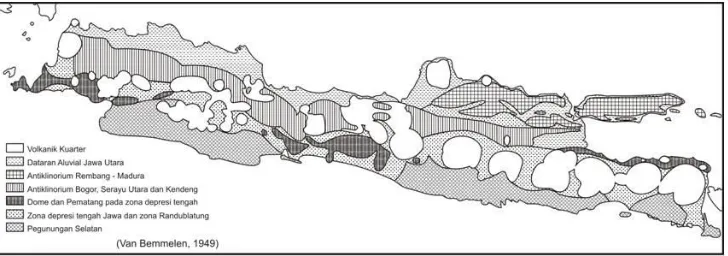
There are several mountainous areas in Java Island where mass movements often take place, such as North Serayu Mountains, South Serayu Mountains, Menoreh Hills, and Southern Mountains [7]. Map showing distribution of the physiographic zones in Java has been figured by van Bemmelen (1949), as can be seen in Fig. 4.
Fig.4 Physiographic Map expressing the Geologic Environments of Java Island [12]
1. Tertiary Volcanic Arc Zones
1.1. Menoreh Hills
Examples of Tertiary Volcanic Arc in Java are Menoreh Hills and Southern Mountains. Menoreh Hills is a raised and further strongly denudated dome [12]. It shows hilly morphology with slopes inclination generally more than 40% or 20o [11]. Rock constituent successively starting from the bottom is marl and sandstone of Eocene, volcanic breccias, and lava deposits; of Early Miocene; reefs limestone of middle Miocene; layered limestone, tuffaceous-calcareous sandstone of middle to late Miocene; and alluvial deposits. Faults pattern is relatively radial on the wings, while some ancient eruption centers are found at the top of the dome [12]. Volcanic rocks of Menoreh Hills are in general highly fractured and weathered, forming soil that the thickness can be more than 5 m to 10 m [7].
Mass movements occur in this area can be classified into landslide (soil slide / landslide). The boundary between fresh rock and soil usually plays as the sliding plane. Shape of the sliding plane is often not purely circular or planar, but rather a combination of both [5]. Their occurrence is always triggered by rain water that seep into soil to reaches the boundary between fresh rock and soil. Further it will extend pore water pressure, reducing the rock strength. Landslide generally happens with high speed, and or a combination of sliding and flowing, as happened in Kemanukan Purworejo [5], Panusupan village, and Ngelo, Purwodadi. The sketch of mass movement typology at Ngelo and Purwodadi villages is shown in Fig.5.
Fig. 5 Typology of Slope Movements in Ngelo and Purwodadi [5]
1.2. Southern Mountains
alluvial deposits, and sediment of Mount Merapi. Due to the rain fall intensity that is relatively high, thick soil is commonly formed as the result of weathering process, with thickness ranges 0.3 m to 2 m.
Ground motion in the Southern Mountains is relatively not intensive to occur compared to that of Menoreh Hills. The mass involved in the movement is generally soil as the product of volcanic breccias weathering. Border of fresh rock and soil plays the role as the avalanches sliding plane can be a common thing in this area.
There was a landslide at River Widara, involving soil-rock that moved over the sliding plane in the form of marl layer. Even though rarely to occur, there is a planar gliding type of motion. This kind of mass movement happened in the south Patuk in the year 1995 [7]. In the year 2011 such a landslide happened at Ngawen District, Gunung Kidul Regency (Fig 6). Some mass movements in Patuk of Southern Mountains often affect the disturbance of Yogyakarta - Wonosari traffic.
Fig. 6 Landslide of Ngawen, Southern Mountains [13]
2. Tertiary Back Arc Zones
Back Arc Zones of Java Island is represented by Bogor Zone in the west, North and South Serayu Mountains in the middle part, and Rembang – Kendeng Zones in the east. The zones in general perform as folded mountainous and hilly areas, composed of clastic sedimentary rocks of fine to coarse grained, from clay to coarse sand. Geologic structures perform as syncline and anticline.
In the study area, the back arc basin environment can be differentiated between back arc associated with magmatic activity and back arc without magmatic activity.
2.1. Bogor Zone
Bogor zone is an anticlinoria with west-east fold axis. The anticlinoria core is composed of Miocene epoch rocks, while the wings are occupied by younger rocks of Pliocene - Pleistocene [2], consisting of sandstone, mudstone and breccias. There are some hypabisal intrusions, conglomerates and volcanic sediments, and limestone lenses [2]. In Middle Eocene-Oligocene epoch Bogor Basin was the front of magmatic arc, it changed into a basin behind the magmatic arc on Early Miocene-Pliocene epoch. [2].
that geologically composed of volcanic formation, involving soil and debris of weathered rocks. The moving materials commonly develop from sliding to flowing, because the soil is very saturated by water in the rainy season [5]. This kind of mass movement happened in February 2001 at Cipanas District, Lebak Regency, Banten Province. In this incident, the material had been involved were thick soil of weathered rock, moved on the sliding plane of the boundary between the fresh rock and the soil, with high speed of movement [5].
Fig.7 Typology of Mass Movement in Cipanas District, Lebak Regency, West Java [5]
2.2. North Serayu Mountains
North Serayu Mountains is located southward of the North Coast of Java. The mountains are strongly folded. In the west, the mountains are separated from Bogor Mountains by Mount Slamet volcano, and in the east, separated from Kendeng Ranges by Mount Ungaran volcano. Anticline, syncline, reverse as well as horizontal faults are often found in this area.
Lithology composing North Serayu Mountains can be grouped into two categories, namely clayey rocks and volcanic rocks. Clayey rock groups are composed of silty marly sandstone, interbedded of claystone and sandstones, shale and marl of Tertiary period. There also exist a group of volcanic rocks of Quaternary period consisting of breccias, agglomerates and lava of Jembangan formations. Volcanic group is conformably lies over the clayey group. The volcanic rocks of North Serayu Mountains are from the Quaternary tectonic period [6]. The clayey group is strongly folded, while the volcanic group in general is not folded, but only relatively low inclined (less than 15o) [6].
Fig. 8 Various typologies of mass movements in Karangkobar, Central Java [6]
In this area, not just volcanic rock that move, but the clay rock of Merawu formations also particularly prone to avalanches, as influenced by geological structure (bedding, joints, and faults). The type of motion that involves all of the formations among others is landslides, avalanches of debris, soil creep, land subsidence, and debris flow. Tectonic symptom in North Serayu Mountains is known as gravity tectonic [12], because it is influenced by gravitational force. Because it is expressed in the form of sliding and gliding of large-scale rock mass (body hills, mountains), then this phenomenon is also called gliding tectonic [6]. According to Van Bemmelen [12], the average velocity of creep is 24 cm to 40 cm every year.
In the year 2010, a large scale of landslide occur involving thick soil apart of Mount Pawinihan foot slope, killing tens people of Sijeruk village, Banjarmangu, Banjar Negara Regency. The type of mass movement is landslide with rotational movement. Such a similar accident was repeated to happen in the year 2014. In this moment mass which was sliding is soil of Mount Telagalele foot slope at Jemblung village. The accident belongs to land slide of circular plane failure and rotational movement, killing peoples of Karangkobar district, Banjar Negara Regency (Fig 9).
Fig. 9 Landslide of Gunung Telagalele, Karangkobar, Banjar Negara regency [16]
2.3. South Serayu Mountains
alluvial deposits. The last two units have Quaternary age. Geologic structures exist in the Melange Complex are reverse faults and lateral slip faults. In the upper stratigraphic formation, the geological structures are also complex. South Serayu Mountains can be classified to back arc zone without magmatic activity association [3].
There was a landslide occurred in Kebumen Regency, involving volcanic clastic rocks. In this incident, geologic structures such as bedding plane, cracks and joints are usually very influential. Some events have been driven by layering structures that the dip is in line with the slope, as happened in Seling village. While in Panusupan, avalanches trend is in line to the direction of the joint plane orientation [8].
Rock layering structure in landslide-prone areas generally has a relative movement parallel and the inclination direction of the slope. The slope of bedding ranges 17O - 23o.
While the slope is usually incline more than 20o. The mean inclination of bedding planes is
smaller than the inclination of the slope. This makes dangerous conditions, because it will easy to avalanches through the discontinuity planes. Clayey and silty sedimentary rocks are classified into impermeable. They are easily to become slipper, and forming mud when they are in water-saturated condition. When such soil mass lay on bedding system, it will be able to function as the sliding plane of the mass failures [8].
In Seling village, Kebumen Regency there has been a soil creep involving more or less 2 x 1.5 kilometers area with thickness of the moving mass is between 0.5 meters to more than 9 meters. Boundaries of the moving land forms horseshoe. The soil creeps over a formation consisting of tuffaceous mudstone and tuffaceous sandstone, northwest - southeast (N310oE) direction and tilted to the northeast of more or less 15 ° [8]. There were cracks found in the area that floats on the sliding plane, striking relatively parallel to the slope. The speed of creep is 2 cm - 4 cm / day, moved to northwest - southeast (N305oE), toward the river valley [8]. Thus mass movement of soil/rock in South Serayu Mountains can be broadly grouped into two, namely the movement at high speed such as happen in Penusupan, and movement with low speed such as in Seling (Fig 10). Mass movement at high speed occurs at the slope more than 20o, in contrary motion at low speed happens on slopes of less than 20o. The model of land slide at Penusupan village, Sruweng, Kebumen Regency is as shown in Fig. 11.
Fig. 11 Type of Slope Movement in Penusupan Area, Kebumen Regency [9].
3. Quaternary Volcanic Arc
The volcanic arc of Quaternary period in Java Island is specified by the existence of active volcanoes that belong to strato and composite type with activity producing the combination of pyroclastics deposits consist of breccias, loose sand, lava, and lahar deposits. The petrological composition of the volcanic deposits are mainly andesitic with low quartz content, therefore the deposits are relatively easier to be weathered. The thickness of soil ranges from 2 m to more than 10 m [7]. Landslides commonly occur within thick soil, which is inclined of more than 20o.
On such active volcanoes as Mount Merapi and Mount Semeru, valleys which are positioned on the upper slope commonly fully filled with pyroclastic materials. When these materials are mixed with rain water, the density will to become higher. In the very saturated condition, lead by gravity, the pyroclastic materials will flow down slope as lahar. On the foot slopes of Quaternary volcanoes, landslides also frequently occurr, for example on the foot slopes of Mount Lawu and Mount Merbabu (Central Java), at Karanganyar area (Fig. 12)
Landslides on the foot slopes of Mount Merapi frequently occur near the flow stream. Common types of movement are soil slides (landslides) involving weathered rock or soil, or loose sand. Another factor that often functions as the driving force of mass movement is the presence of clay layers at a depth of about 50 - 60 m below the surface. Avalanches caused by human activities is also common in places where sand and stone are mined, such as might occur in River Krasak (Magelang, Central Java), River Gendol (Sleman, Yogyakarta), and River Woro (Klaten, Central Java).
In the year 2005 a soil avalanches occurred in Ciloto, West Java involving the zone of ± 40 acres on the slopes of a hill [1]. Ciloto landslide included weathered volcanic rocks as breccias, clay, silt, and sand. Infiltration of surface water into the ground making the material is easy to slide. Kind of the sliding material is categorized as gravel or a mixture of debris [1].
Discussion
In the areas prone to landslides of Java Island, rocks easiest to move are clayey stones and weathered volcanic rocks. In the North Serayu Mountains, mass movement occurrence mostly involves claystone (Merawu Formation) and volcanic rocks (Jembangan Formation). In the South Serayu Mountains, mass movements generally only involve clayey rocks (Panosogan Formation and Halang Formation). In the Menoreh Hills, landslides usually involve only weathered volcanic rocks (Kaligesing Formation).
Rock units that are widely available in mountainous areas prone to landslides in general tend to form advanced argillic below the soil layer which is rich in clay minerals. Weathered volcanic rocks are capable of producing kinds of clay minerals including montmorillonite, occurs from alteration of plagioclase, known to be impermeable mudstone, plastic, soft, easily to be eroded, the specific gravity varies 2.0 to 2.25, cohesive force 0.4 to 0.7 kg / cm2 and, the friction angle () ranges 2° - 15°, and easy to silt up when submerged in water [4].
Tertiary volcanic deposits in Yogyakarta and Central Java is composed of andesitic, commonly thick (over 300 m), weight (specific gravity between 2.6 to 2.75), hard, brittle, with cohesion (c) = 0.3 to 0.75 kg/cm2, friction angle () between 25o - 35o. A fairly
intensive weathering forms thick soil (5 m to 10 m). Laboratory testings indicate that at several locations of the slopes of Mount Sumbing, the impermeable rock has a coefficient of permeability less than 1 x 10⁻⁷ m/s, and the coefficient of water in the soil is higher than 1 x 10⁻⁶ m/s [5]. The cohesive forces in the sliding plane ranges between 0.08 kg/cm2 up to 11 kg/cm2, the friction angle () between 30o to 36o [5]. Due to weathering, the surface of volcanic rocks is commonly decomposed into clay. Physical properties that are relatively tight, causes the rocks become cracked and splited apart, iniciating rainwater to seeping. In saturated condition, pore water preasure will increase breaking the ground to easier sliding.
Although mass movement in some physiographic zones shows different characteristics, but in general it can be defined that the places where landslide occurs perform mountainous or hilly topography with slopes of more than 20o. Rainfall in the area in general is high, it is more than 2500 mm/year [5].
Model of Correlation between Tectonic Setting and Mass Movement Characteristic
Tertiary soil & debris slide
Sliding plane: Joint
The conclusions of this study are as follows:
1. Plate tectonic boundary of western Indonesia is subduction convergent, with components of trench, accretionary wedge, fore arc basin, volcanic arc, and back arc basin. Especially for Java Island, the tectonic components already exposed can be divided into 4 (four) physiographic environments, including Volcanic Arc of Tertiary period, Back Arc of Tertiary period associated with magmatic activity of Quaternary period, Back Arc of Tertiary period without magmatic activity association, and Volcanic Arc of Quaternary period.
2. The tectonic regime of Java which is compressional brings about the development of rising mountains and areas with sloping that play as the main factor of mass movement occurrence. The potential of mass movement is supported by high rainfall of Wet Tropical climate, thick weathered rock and soil, and triggered by earthquake.
4. Tertiary Back Arc with Quaternary magmatic activity association is predominantly composed of massive volcanic rocks underlain by folded, plastic, clayey sedimentary rocks. The characteristic of mass movement, especially North Serayu Mountains is known as the gliding tectonic, expressed as soil slide, debris slide; rock block glide, and deep rotational rock slide.
5. Tertiary Back Arc without magmatic association is predominantly composed of plastic sedimentary rocks, calcareous, marly, and volcanic sedimentary rocks. The geologic structures are folds, and faults. Mass movement characteristics are translational soil & debris slide with bedding plane, or joint as the sliding planes; and combination of rotational and translational debris & rock slide with bedding as the sliding plane.
6. Quaternary Volcanic Arc is mainly built of old and new volcanic products such as lava, pyroclastic breccias, and laharic deposits of andesitic composition. The characteristic of mass movements are rotational soil slide exists in non active Volcanic Arc; and rotational soil slide and mud flow occur in active Volcanic Arc.
References
[1] Abidin, H.Z., Kahar J., Santoso, D., 2006. The Use of Geodetic Method to Identify the Characteristic and Type of Landslide, Proc. Annual Meeting III – T. Geomatika ITS Surabaya, 7 Desember 2006
[2] Efendi, A.C., Kusinama, Hermawanto B., 1998. Geologic Map of Bogor Sheet, Java, Scale 1:100.000, Center of Geological Research and Development.
[3] Hamilton, W. 1979. Tectonic of the Indonesian Region, U.S. Geological Survey, U.S. Government Printing Office
[4] Hermawan 1993. Engineering characteristic of clay of Subang Formation and Old Volcanic deposits in Kalijati Area, Proc. PIT IAGI XXII, Vol 1, 407-715
[5] Karnawati, D. 2002. Landslide Disaster of Indonesia in the year 2001; Evaluation and Recommendation, Proc. Symposium on Sediment Disaster Prevention, 437 – 448.
[6] Kusumayudha S.B. 2015. Gunung Telagalele and Gravitational Tectonic, SKH Kedaulatan Rakyat [7] Kusumayudha, S. B. & S. Koesnaryo 2001. Landslide Phenomenon in Central Java, DIY, from
Engineering Geology Point of View: Needs Social-cultural Approach, Buletin Teknologi Mineral [8] Paripurno, E.T & Kusumayudha S.B. 2001. When the Landslides Occur, Kedaulatan Rakyat, 2001 [9] Pratiknyo, P. & Kusumayudha, S.B. 2002. Landslides of Penusupan, Sruweng, Kebumen: How to handle, Year Book of Disaster Mitigation, Proc. BPPT (Board of Assessment and Application of Tecnology), 1-24 – 1-28
[10] Suyoto 1994. Stratigraphic Sequence of the Gunungsewu Carbonate, Proc. PIT IAGI XXIII, Vol 1, 19-32.
[11] Toyo Santoso Dipo, H. 2002. Landslide disaster of Kulon Progo and Mitigation, Proc. Symposium on Sediment Disaster Prevention, 40 – 49.
[12] Van Bemmelen, R. W. 1949. The Geology of Indonesia, Vol I A, Martinus Nijhoff, The Hague [13] http.nasional.news.viva.co.idnews
[14] http.www.jatengnews.com2011 [15] http://www.virtualuppermantle.info [16] http.vauzi.com3
![Table 1 Mass Movements of Java, 2000 – 2015 [1, 5, 7, 8, 9, 11, 13, 14, 15, 16 ,17]](https://thumb-ap.123doks.com/thumbv2/123dok/1648352.2069963/6.595.74.513.182.632/table-mass-movements-java.webp)
![Fig. 5 Typology of Slope Movements in Ngelo and Purwodadi [5]](https://thumb-ap.123doks.com/thumbv2/123dok/1648352.2069963/8.595.194.403.417.561/fig-typology-slope-movements-ngelo-purwodadi.webp)
![Fig. 6 Landslide of Ngawen, Southern Mountains [13]](https://thumb-ap.123doks.com/thumbv2/123dok/1648352.2069963/9.595.176.424.293.437/fig-landslide-ngawen-southern-mountains.webp)
![Fig. 8 Various typologies of mass movements in Karangkobar, Central Java [6]](https://thumb-ap.123doks.com/thumbv2/123dok/1648352.2069963/11.595.186.410.514.639/fig-various-typologies-mass-movements-karangkobar-central-java.webp)
![Fig. 10 Type of Landslide at Seling Village. The sliding plane is bedding plane or joints [9]](https://thumb-ap.123doks.com/thumbv2/123dok/1648352.2069963/12.595.159.433.556.698/type-landslide-seling-village-sliding-plane-bedding-joints.webp)
![Fig. 11 Type of Slope Movement in Penusupan Area, Kebumen Regency [9].](https://thumb-ap.123doks.com/thumbv2/123dok/1648352.2069963/13.595.208.390.580.718/fig-type-slope-movement-penusupan-area-kebumen-regency.webp)