2011 National University of Singapore, Department of Architecture Global Visions: Risks and Opportunities for the Urban Planet
PARK CONNECTOR NETWORK PLANNING IN SINGAPORE:
INTEGRATING THE GREEN IN THE GARDEN CITY
Tanuwidjaja, Gunawan*
*Lecturer of Petra Christian University, Surabaya, Indonesia, Email:[email protected]
ABSTRACT:
Singapore successfully achieved the Global City in a Garden, because of good political will, careful planning and strict development control initiated by the former PM Lee Kuan Yew in 1960 - 1970s. The Garden City Vision was originally proposed by Mr Lee Kuan Yew, and it was later materialised by Parks and Recreation Department (or later named The National Parks Board/ NParks).
The NParks vision was to join the national effort creating the best environment for Singaporean and residents to live work and play in, meanwhile its pillars of progress were to grow Singapore’s Garden infrastructure, to cultivate Singapore as premier horticulture hub and to ignite the community passion for greenery.
Park Connector Network (PCN) in Singapore was an integrated approach of Greening and Recreational Strategy. It generated the social and recreational activities in the neighbourhood as well as increased biodiversity within. For example, UluPandan Park Connector was found popularly used. Meanwhile, it also served as habitat for native species of birds. This showed that PCN also contributed to successful conservation and environmental sustainability of the City (Briffet, 2004).
Further improvement of PCN was conducted with benchmarking research, infrastructure improvement. And this effort proved excellent initiatives from Singapore Government for sustainable recreational activities. It also could be transformed to other countries as one integrated sustainable greening and recreational strategy.
KEYWORDS: Garden City, Global City in a Garden, The National Parks Board (NParks), Park Connector Network, PCN, Greenway, Urban Planning, Integrated approach of Greening – Recreational Strategy, Social and recreational activities, Habitat for native species of birds
1. INTRODUCTION
Singapore, had achieved remarkable economic growth of 2-10% and Gross National Income (GNI) $ 250,387.9 M. and the Garden City status, with strong political will, prudent planning and strict development controls (Dale, 1999; Yuen, 2000; NParks, 2006, and Singapore Dept of Statistics, 2008).1
The Singapore’s Garden City vision was stated by the former Prime Minister, Mr. Lee Kuan Yew in 1960 - 1970. In those years, he set up several vital organisations for the development of Singapore. And one of them was The Parks and Recreation Department (later consolidated into The National Parks Board/ NParks). This effort was conducted to ensure the sustainable development of Singapore. 2
1 Dale, Ole Johan (1999)., Urban Planning in Singapore The Transformation of a City, Oxford University
Press.
Yuen, B., (2000), Singapore Housing: A Strategy for Urban Development and Regeneration, The City Region in a World of Globalisation: Urban Strategies for Sustainable Development Conference, in Bergen Norway, 18 – 22 June 2000. Source: http://publications.ksu.edu.sa
National Parks Board, Singapore (2006-2007), Annual Report, pp 2-7, http://www.nparks.gov.sg, Singapore Department of Statistics ; Yearbook of Statistics Singapore 2009,
http://www.singstat.gov.sg/
On top of the organisations’ creation, he institutionalised several community-based movements, such as the Tree Planting Day and Greening Movement in Singapore. His Garden City Vision was later spearheaded by The National Parks Board (NParks). 3
1.1 Singapore’s Concept Plan
The Garden City concept was incorporated into the Concept Plan 1971, planned to be achieved the following 40-50 years. The latest one, Concept Plan 2001, called for Singapore to become ”a thriving, world-class city in the 21st Century.” 4
The 2001 Concept Plan proposed the “Ring Concept” consisting of Expressways and Mass Rapid Transit (MRT) system. Adjacent to ”the ring,” the high-density, high-rise towns were planned, and also mixed with several lower-density residences. The “Ring” structure surrounded the central water catchment area, which was legally gazetted as “Nature Reserves.”
Further, the commercial areas and green open spaces were planned in the core area of new high-rise-towns. This further reduced the traffic and the development pressures. As a result, more space could be allocated for greenery and more recreational activities could be offered.
1.2 Role of NParks and Sustainable Development
In the context of the Concept Plan of the Garden City, NParks played a major role in creating a city to live work and play in with strategy of growing Singapore’s garden infrastructure, cultivating Singapore as premier horticulture hub, and igniting the community passion for greenery. Further, those tasks required commitment and excellence in the field of park planning & research, urban greening & horticulture, management, and nature conservation. 5
Figure 1. The Green and Blue Plan in Concept Plan 2001
Source: Urban Redevelopment Authority of Singapore, http://www.ura.gov.sg and National Park Board http://www.nparks.gov.sg,
Economic Boom, Harpec Collins Publisher, PP. 173-183.
DBJ Report (2004), Building A 21st Century City, Optimizing Land Resources and Nurturing A Garden Within A City, March 2004, Development Bank of Japan, Representative Office in Singapore, source: www.dbj.go.jp
3 Ibid.
In terms of park provision ratios, NParks, in consultation with the URA (Urban Redevelopment Authority), targeted providing 0.8 ha of Parks / 1000 population. And in 2009, NParks managed 2,502.10 ha of Parks in Singapore comprising 56 Regional Parks, 242 Neighbourhood Parks and 25 Park Connectors. Additionally, 3,358 ha of Nature Reserves, of the Istana Park (42 ha in size), 2,517 ha of Roadside Greenery, 1,710 ha of Vacant State Land and 9 ha of Government Premises were also under Nparks management. All of them contributed to the total of 9,651 ha of Green Spaces of Singapore, which constituted of 14% of Singapore total land area. 6
In this respect, NParks contributed significantly to “the Sustainable Urban Development (SUD) of Singapore.” The framework actually comprised 7 pillars, such as: economic sustainability, cultural sustainability, social sustainability, political sustainability, educational sustainability, demographic sustainability, and environmental sustainability (Wong T. C. et.all., 2008).7 In the framework, NParks succeeded in meeting the cities greenery needs and achieving the Environmental and Social Sustainability of Singapore. And clearly, the sheer scale of parks and greenery reduced the local heat island effect and improved the thermal comfort of the city.
2. GREEN NETWORK IN SINGAPORE: A KEY GREEN INFRASTRUCTURE
The vision the Garden City had been achieved also with the development of the Park Connector Network. In this section, the writer would to share the integrated planning and development of PCN, and how it contributed to the social and environmental sustainability of Singapore.
2.1 Genesis of the PCN
The Parks and Recreation Department (now NParks) first proposed the Park Connector Network (PCN) in 1992 for alternative recreation options for Singaporeans. Three hundred km of Park Connector (PC) were targeted to be developed in 30 years time. The Park Connectors were initially planned abutting the drainage reserves, water bodies connecting the national, regional and local parks. The PCN were easily implemented because of the land availability. The Coastal areas were utilised later because good connectivity. Common activities held within the PC and the coastal parks comprised of cycling, jogging, walking, and other recreational activities for Singaporean. 8
6National Parks Board, Singapore (2008-2009), Annual Report, http://www.nparks.gov.sg
http://www.singstat.gov.sg/stats/keyind.html
7 Wong T-C., Yuen B., and Goldblum C. (Eds.) (2008), Spatial Planning for a Sustainable Singapore,
Springer in Association with the Singapore Institute of Planners. Singapore
8National Parks Board, Singapore (2006-2007), Annual Report, pp 2-7, http://www.nparks.gov.sg,
Briffett,C., Sodhi,N., Yuen,B., Kong,L., Green corridors and the quality of urban life in Singapore, accessed from: http://ag.arizona.edu/pubs/adjunct/snr0704/snr07041g.pdf in 2010
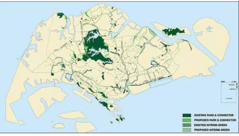
Figure 2. The Park Connector Vision
Source: National Park Board http://www.nparks.gov.sg, http://habitatnews.nus.edu.sg
Figure 3. The Park Connector Network finished Source: National Park Board http://www.nparks.gov.sg,
Figure 4 to 7. The Photos of Park Connectors
(Upper Left - Alexandra Canal Linear Park, Upper Right - Changi PC, Bottom Left – Jurong PC, Bottom Right – SimpangKiri PC)
Source: National Park Board, http://www.nparks.gov.sg
2.2 Challenges in implementing the PCN
The planning, design, construction and maintenance of the PCN required close inter-government agency collaboration. To ensure the successful PCN implementation, NParks coordinated between the relevant sectored agencies.
The greatest challenge of PCN implementation was the limited contiguous areas in the urban areas. Limited space within drainage reserves, road reserves and parks had resulted in challenges such as less continuous terrains.
On the other hand, PC oftentimes generated much social – recreational activity from the surrounding neighbourhood. From public feedback, residents living near certain PCs had enjoyed using the PC for jogging, cycling, roller-blading, strolling, and walking. Some even practiced “tai-chi” and other physical exercises in several locations.
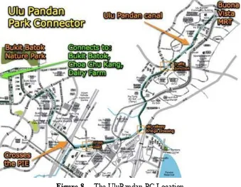
For example, UluPandan Park Connector was reportedly used by more than 4087 users/ day in Briffet (2004). The research also reported that 77% had visited the park connector from nearby residential estates. And 85% of users were recorded as the regular users of the PC, at least once a week. 9
Briffet (2004) also reported that 67.7% of the UluPandan PC’s users’ intensions were to perform physical exercise. Meanwhile, 50% of them enjoyed its environment, good air, quiet, and vegetation. And lastly about 40% considered it valuable for communal relaxation and recreation. The report actually illustrated that the the PC was found successful in improving social and environmental sustainability of the area.10
In terms of nature conservation, which was another core function of the NParks, it was reported that several PCs also provided habitats for certain native species. These species included the Purple-backed Starling, JavanMyna and Pink-necked Pigeon, Greater Racket-tailed Drongo, Olive-winged Bulbul, Short
9Briffett, C., Sodhi, N., Yuen, B., Kong, L., Green corridors and the quality of urban life in Singapore,
accessed from: http://ag.arizona.edu/pubs/adjunct/snr0704/snr07041g.pdf in 2010
10Op.cit 9
tailed Babbler and Greater Green Leafbird. In fact, these species were present in the UluPandan PC (Briffet, 2004). Currently, the National Biodiversity Centre – a branch within the NParks – was undertaking wildlife surveys in the PC. And, the PCN were proven contributing to biodiversity conservation and environmental sustainability of the City.
Figure 8. The UluPandan PC Location
Source: National Park Board, http://www.nparks.gov.sg,
Figure 9 to 12. The UluPandan PC Photos Source: National Park Board, http://www.nparks.gov.sg
sanctuary for Singaporean from hustle and bustle of the City.
Further, the good connectivity of UluPandan PC with the Town Centre and Community Facilities had made the cyclists and pedestrian able to reach alternative locations easily. And this generated a beneficial effect of creating an alternative convenience route for commuters. In short, all these findings point to the integrated PCN planning, design and development.
2.3 Updates and Further developments
Nparks PCN goal was to develop a 300km island-wide network of green corridors by FY2015. And NParks had finished about 112 km of park connectors in 2009. The main PC, The Western Loop, was completed in 2009 and linked several Regional Parks in the west. Meanwhile, the Northern Loop was expected to be ready in end-2010. The Eastern Loop or Eastern Coastal PCN was completed in 2007. And the new PCs were planned and designed using benchmarking PC research from other countries.11
2.4 Research and Benchmarking of PCN
I conducted a benchmarking research of Park Connector (Greenway) Planning and Design in several cities and countries during the internship program of MSc. Environmental Management and NParks. Under the supervision of Ms Kim Goh and Mr John Lee Tsen Yang, I evaluated the Greenway in Seattle - Washington, Portland - Oregon and New York City, (all 3 cities in USA); Vancouver, Canada; Copenhagen, Denmark; Australia (AUSTROAD); and UK (Sustrans).12
In general, I found that the successful PCN or Bikeways (Europe terms) or Greenways (US terms) were integrated with Urban Planning and Development. Actually this strategy would improve the experience of the Bikeways/ Greenways users and reduce pollution level of the use of motorised vehicle. Local businesses adjacent to the Bikeways/ Greenways benefitted from this strategy because of the higher volumes of customers. Furthermore, proximity to the Bikeways/ Greenways could be a potential selling point for residential properties in the vicinity.
Later, an integrated cycling strategy was identified as a key aspect in sustainable PCN planning. This broad strategy comprises of improvements made to the cycling lanes in the PCN, construction of bike lanes in the road reserve, integration of PCN and bike-lane network with other mass transportation modes. It was also found that effective campaigning with respect to safe riding and more tolerant use of shared spaces would augment the integrated strategy. Close collaboration and integration between authorities was a critical success factor in the implementation of the PCN.
At the same time, LTA (Land Transport Authority) Singapore promoted the aspect of road safety and transportation’s efficiency in the Land Transport Master Plan 2008. They were committed to provide better bicycle parking facilities around MRT stations and bus interchanges; to close short gaps between the park connectors and transport nodes; to cater to commuters who cycle to the MRT stations or bus interchanges; and to install appropriate road signs to alert motorists to the presence of cyclists along frequently used routes.13 I believed that these would also assist the cyclists and eventually support concept of green recreational transport in Singapore.
To further enhance the cycling experience, NParks provided several cyclists’ facility within the PCN. Seven pit-stops were later developed in seven parks in Eastern PCN. In a typical PCN pit-stop, bicycle rental facilities were provided. This would allow users to rent and return bicycles in any of the seven pit-stops at their convenience. And all additional programs mentioned above had shown serious efforts by the
11National Parks Board, Singapore (2008-2009), Annual Report, http://www.nparks.gov.sg, 12http://www.seattle.gov/transportation/
13 Land Transport Authority (2008), Land Transport Master Plan 2008, www.lta.gov.sg
Government of Singapore to create sustainable Park Connector Network in the Garden City.14
3. CONCLUSION
The NParks had successfully planned, designed and implemented the Park Connector Network (PCN) in Singapore. This was an excellent example of taking an integrated approach in Greening and Recreational Strategy. It was proved successful in catering for social and recreational activities as well as increasing the overall levels of biodiversity. And it should be used as a model for other countries as a strategy to face Global Challenges in the urban areas.
ACKNOWLEDGEMENT
- National Parks Board (NParks)
o Mr Sim Cheng Hai, Director of Policy and Planning; o Ms Kim Goh, Assistant Director of Physical Planning;
o Mr John Lee Tsen Yang MSc. BSc. (Research Supervisor - Senior Programme Officer, National Biodiversity Center - Coastal and Marine);
- Singapore Government/ State boards; - Petra Christian University;
o
Ir. Handoko Sugiharto, M.T. Dean of Civil Engineering and Planning Faculty;o Agus Dwi Hariyanto, M.Sc., ST., Head of Architecture Department; o Ir. Joyce M. Laurens, M.Arch., Lecturer of Architecture Department; o Rully Damayanti MArt., ST., Lecturer of Architecture Department;
o
Luciana Kristanto MT.,ST., Lecturer of Architecture Department;- National University of Singapore
o Dr. Malone Lee-Lai Choo, Director of Centre of Sustainable Asian Cities and Former Director of MSc. Environmental Management Program;
o Prof. George Ofori, Director of MSc. Environmental Management Program; o Prof Clive Briffett, Prof Navjot Sodhi, Prof Bellinda Yuen, Prof Lily Kong; - Dr. Ho Hua Chew, Nature Society Singapore;
- Mrs Joyce Martha Widjaya, Senior Researcher of Research Institute of Socio-Economic and Community Development, Public Works Department.
REFERENCES
[1] Briffett,C., Sodhi,N., Yuen,B., Kong,L., Green corridors and the quality of urban life in Singapore (1984), accessed from: http://ag.arizona.edu/pubs/adjunct/snr0704/snr07041g.pdf in 2010
[2] Dale, Ole Johan., Urban Planning in Singapore The Transformation of a City, Oxford University Press, 1999.
[3] DBJ Report Building A 21st Century City, Optimizing Land Resources and Nurturing A Garden Within A City, March 2004, Development Bank of Japan, Representative Office in Singapore, source:
[12] Land Transport Authority, Land Transport Master Plan, 2008, www.lta.gov.sg
[13] Lee,K Y., From a Third World to the First, The Singapore Story, Singapore and The Asian Economic Boom, Harpec Collins Publisher, 2000, PP. 173-183.
2
[14] National Parks Board, Singapore , Annual Report, 2006-2007, http://www.nparks.gov.sg, [15] National Parks Board, Singapore, Annual Report, 2008-2009, http://www.nparks.gov.sg [16] Singapore Department of Statistics ; Yearbook of Statistics Singapore, 2009.
[17] Urban Redevelopment Authority of Singapore, http://www.ura.gov.sg
[18] Wong T-C., Yuen B., and Goldblum C. (Eds.), Spatial Planning for a Sustainable Singapore, Springer in Association with the Singapore Institute of Planners. 2008, Singapore