Fifth Meeting of the Automatic Dependent Control Committee (ADSP/5); thirty-ninth meeting of the European Air Navigation Planning Group (EANPG); Twelfth Meeting of the Commission on Overcoming Barriers (OCP/12); Second Meeting of the Panel on Operational Data Links (OPLINKP/2); Twelfth Meeting of the Instrument Flight Procedures Committee (IFPP/12); Meteorological Department (MET) Meeting (2014) (referring to Recommendation 5/1).
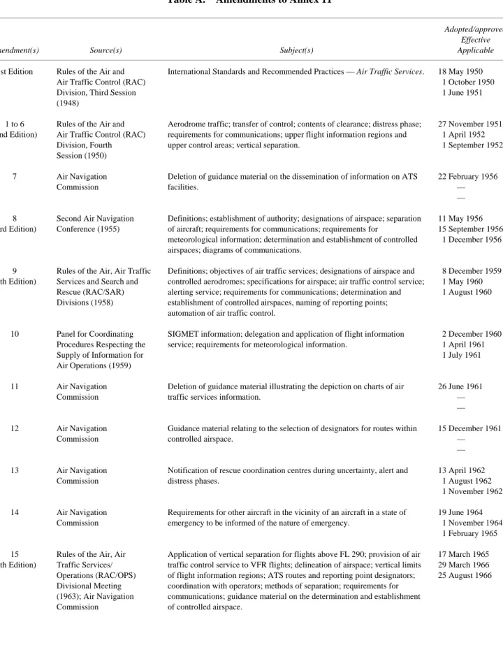
INTERNATIONAL STANDARDS AND RECOMMENDED PRACTICES
DEFINITIONS
Authorization for an aircraft to proceed under conditions specified by an air traffic control unit. Specified information provided to air traffic services units relative to an intended flight or portion of a flight of an aircraft.
GENERAL
- Establishment of authority
- Objectives of the air traffic services
- Divisions of the air traffic services
- Determination of the need for air traffic services
- Designation of the portions of the airspace and controlled aerodromes where air traffic services will be provided
- Classification of airspaces
- Performance-based navigation (PBN) operations
- Performance-based communication (PBC) operations
- Performance-based surveillance (PBS) operations
- Establishment and designation of the units providing air traffic services
- Specifications for flight information regions, control areas and control zones
- Identification of air traffic services units and airspaces
- Establishment and identification of ATS routes
- Establishment of change-over points
- Establishment and identification of significant points
- Establishment and identification of standard routes for taxiing aircraft
- Coordination between the operator and air traffic services
- Coordination between military authorities and air traffic services
- Coordination of activities potentially hazardous to civil aircraft
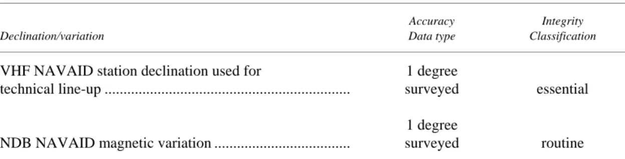
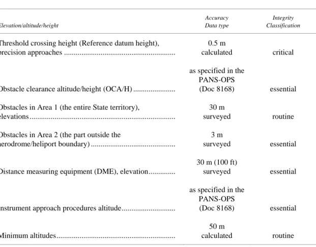
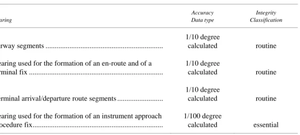
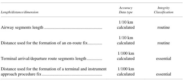
- Aeronautical data
- Coordination between meteorological and air traffic services authorities
- Coordination between aeronautical information services and air traffic services authorities
- Minimum flight altitudes
- Service to aircraft in the event of an emergency
- In-flight contingencies
- Time in air traffic services
- Establishment of requirements for carriage and operation of pressure-altitude reporting transponders
- Safety management
- Common reference systems
- Language proficiency
- Contingency arrangements
- Identification and delineation of prohibited, restricted and danger areas
- Instrument flight procedure design service
Note.— Services provided by various air traffic control units are listed in 3.2. Footnote. For aircraft subject to unlawful interference, see Coordination between military authorities and air traffic services.
AIR TRAFFIC CONTROL SERVICE
- Application
- Provision of air traffic control service
- Operation of air traffic control service
- Separation minima
- Responsibility for control
- Transfer of responsibility for control
- Air traffic control clearances
- Control of persons and vehicles at aerodromes
- Provision of radar and ADS-B
- Use of surface movement radar (SMR)
Footnote. Guidance material relating to the implementation of composite lateral/vertical separation is contained in the Air Traffic Services Planning Manual (Doc 9426). A controlled flight must be under the control of only one air traffic control unit at a given time. Responsibility for the control of all aircraft operating in a specific block of airspace is assigned to a single air traffic control unit.
Air traffic control clearances shall be based solely on the requirements for the performance of air traffic control service. Note.— The capacity of the air traffic control services concerned will normally be disclosed by the appropriate ATS authority.
FLIGHT INFORMATION SERVICE
- Application
- Scope of flight information service
- Operational flight information service broadcasts
- VOLMET broadcasts and D-VOLMET service
The broadcast message shall not exceed the time allocated to it in the Regional Air Navigation Agreements, ensuring that readability is not impaired by the speed of transmission; Information on important weather phenomena en route shall be in the form of available SIGMET as prescribed in Annex 3. The message transmitted should, if possible, not exceed five minutes in duration, care being taken that readability is not impaired by the speed of the broadcast. ;.
Guidance material on human performance can be found in the Human Factors Training Manual (Document 9683). . f) the broadcast message must be updated on a scheduled basis as determined by regional air navigation agreements. Note.— Guidance material on human performance can be found in the Human Factors Training Manual (Document 9683).
ALERTING SERVICE
- Application
- Notification of rescue coordination centres
- Use of communication facilities
- Plotting aircraft in a state of emergency
- Information to the operator
- Information to aircraft operating in the vicinity of an aircraft in a state of emergency
Note.— The cancellation of action initiated by the rescue coordination center is the responsibility of that center. Air traffic services units will, as necessary, use all available communication facilities to attempt to establish and maintain communication with an aircraft in an emergency condition, and to request news from the aircraft. When an emergency is deemed to exist, the flight of the aircraft concerned must be plotted on a map to determine the probable future position of the aircraft and its maximum range of action from its last known position.
Flights of other aircraft known to be operating in the vicinity of the aircraft in question are also planned to determine their likely future positions and maximum endurance. Note.— If the aircraft is in danger, the rescue coordination center must be notified immediately in accordance with 5.2.1.
AIR TRAFFIC SERVICES REQUIREMENTS FOR COMMUNICATIONS
- Aeronautical mobile service (air-ground communications)
- Aeronautical fixed service (ground-ground communications)
- Surface movement control service
- Aeronautical radio navigation service
6.2.2.1.4 An aerodrome control tower, in addition to connecting to the flight information centre, the area control center and the approach control unit as prescribed in and must have facilities for communication with the associated air traffic services reporting office, when separately established. 6.2.2.3.3 In all cases where automatic transmission of data to and/or from air traffic services computers is required, suitable facilities for automatic recording must be provided. 6.2.2.3.6 Recommendation.— The communication facilities required under 6.2.2.2.2 d) should include provision for communication by direct speech arranged for conference communication, whereby the communication can normally be established within fifteen seconds.
6.2.2.3.7 All facilities for direct voice or data link communication between air traffic services units and between air traffic services units and other units described under 6.2.2.2.1 and 6.2.2.2.2 shall be provided with automatic recording. 6.2.3.1.4 Recommendation.— The communication facilities in 6.2.3.1.3 should allow communication to be established normally within fifteen seconds.
AIR TRAFFIC SERVICES REQUIREMENTS FOR INFORMATION
- Meteorological information
- Information on aerodrome conditions and the operational status of associated facilities
- Information on the operational status of navigation services
- Information on unmanned free balloons
- Information concerning volcanic activity
- Information concerning radioactive materials and toxic chemical “clouds”
Special reports and forecast modifications will be communicated to the units providing approach control service as soon as they are required in accordance with established criteria, without waiting for the next routine report or forecast. Where multiple anemometers are used, the indicators to which they relate must be clearly marked to identify the runway and portion of the runway monitored by each anemometer. Special reports and amendments to forecasts will be communicated to the aerodrome control towers as soon as they are required in accordance with established criteria, without waiting for the next routine report or forecast.
When multiple sensors are used, the displays to which they relate must be clearly marked to identify the track and portion of the track monitored by each sensor. Aerodrome control towers and units providing approach control services shall be kept informed at this time of the operationally important conditions in the movement area, including the existence of temporary hazards, and of the operational status of any associated facilities at the aerodrome(s). ) in which they are involved. .
PRINCIPLES GOVERNING THE IDENTIFICATION OF NAVIGATION SPECIFICATIONS AND THE IDENTIFICATION
OF ATS ROUTES OTHER THAN STANDARD DEPARTURE AND ARRIVAL ROUTES
- Designators for ATS routes and navigation specifications
- Composition of designator
- Assignment of basic designators
- Use of designators in communications
- PRINCIPLES GOVERNING THE ESTABLISHMENT AND IDENTIFICATION OF SIGNIFICANT POINTS
- Establishment of significant points
- Designators for significant points marked by the site of a radio navigation aid
- Designators for significant points not marked by the site of a radio navigation aid
- Significant points used for reporting purposes
- PRINCIPLES GOVERNING THE IDENTIFICATION OF STANDARD DEPARTURE AND ARRIVAL ROUTES
Where the name of a geographical location in the national language chosen for designating a significant point gives rise to problems of pronunciation, a shortened or contracted version of this name, which retains as much as possible of its geographical meaning , be selected;. It should be so constructed, if possible, as to facilitate association with the name of the point in ordinary language. When there is a need to move a significant point, a new name code indicator will be selected.
If the plain language name for a significant point marked by the site of a radionavigation aid selected in accordance with 2.1 is not used, it shall be replaced by the coded designator spoken, in voice communication, in accordance with the ICAO spelling will become alphabet. In applying this principle, particular attention will be paid to the following: .. a) high-speed, high-flying aircraft should not be required to make routine position reports on all reporting points that are mandatory for low-speed, low-flying aircraft;.
AND ASSOCIATED PROCEDURES
- Designators for standard departure and arrival routes and associated procedures
- Composition of designators
- Assignment of designators
- Assignment of validity indicators
- Examples of plain language and coded designators
- Composition of designators for MLS/RNAV approach procedures
- Use of designators in communications
- Display of routes and procedures to air traffic control
- ATS AIRSPACE CLASSES — SERVICES PROVIDED AND FLIGHT REQUIREMENTS
- AERONAUTICAL DATA QUALITY REQUIREMENTS
- PRESCRIPTIVE FATIGUE MANAGEMENT REGULATIONS
- FATIGUE RISK MANAGEMENT SYSTEM (FRMS) REQUIREMENTS
- STATE RESPONSIBILITIES CONCERNING AN INSTRUMENT FLIGHT PROCEDURE DESIGN SERVICE
Note.— Limitations in the display equipment on board aircraft may require truncation of the basic indicator if that indicator is a five-letter name code, e.g. Note.— For the purpose of identifying routes, the words "departure", "arrival" and "visual" described in 2.1.1 d) and 2.1.1 e) are considered to be an integral part of the plain language designation. In all cases in para. 1 above, the State concerned shall approve and remain responsible for all instrument flight procedures for aerodromes and airspace under the authority of the State.
The State shall ensure that the instrument flight procedure planning service provider applies a quality management system at each stage of the instrument flight procedure planning process. The State shall ensure that the maintenance and regular review of instrument flight procedures for airports and airspace under the jurisdiction of the State is carried out.

- Determination of VOR system performance values
- Determination of protected airspace along VOR-defined routes
- Spacing of parallel routes defined by VORs
- Spacing of adjacent VOR-defined routes that are not parallel
- Change-over points for VORs
- Calculation of radius of turn
From this point, drop a perpendicular line to cut the edge of the airway on the inside of the bend. From this point on the inner edge of the airway, construct a line to cut the midline of the airway beyond the bend at an angle of half the angle of rotation. The resulting triangle on the inside of the bend shows the extra air space that should be protected for the change of direction.
Depending on the distance from the intersection to one or both VORs, one or both airways at the intersection may have dispersion. The material is derived from the curve performance criteria developed for RNP 1 ATS routes and can be used in the construction of the required additional protected airspace on the inside of curves, including for ATS routes other than those defined by VOR.
Introduction and applicability of broadcasts
Details of broadcasts
10 minutes prior to entering a designated airspace until exiting that airspace, listening should be monitored on the TIBA frequency. For aircraft taking off from an aerodrome located within the lateral boundaries of a designated airspace, listening observations must begin as soon as practicable after take-off and be maintained until it leaves the airspace. a) 10 minutes before entering the designated airspace or, for a pilot taking off from an airport located within the lateral boundaries of the designated airspace, as soon as practicable after take-off; FLIGHT LEVEL (number) (or CLIMB* TO FLIGHT LEVEL (number)) (direction). ATS route) (or DIRECT FROM (position) TO (position)).
DEPARTING FLIGHT LEVEL (number) FOR FLIGHT LEVEL (number) AT (position and time). ATS route) (or DIRECT FROM (position) TO (position)). For transmissions made when the aircraft is not close to an important ATS point, the position should be given as accurately as possible and in any case to it.
Related operating procedures
Normal position reporting procedures shall be continued at all times regardless of any action taken to initiate or confirm the transmission of traffic information.
- Introduction
- Status of contingency plans
- Responsibility for developing, promulgating and implementing contingency plans
- Preparatory action
- Coordination
- Development, promulgation and application of contingency plans
Such plans should be developed in consultation with other States and airspace users concerned and with ICAO, as appropriate, whenever the effects of service disruptions are likely to affect services in adjacent airspace. Recognizing the fact that the world aviation community is not a party to such disputes, States providing services in airspace over the high seas or of undetermined sovereignty should take appropriate action to ensure that adequate air traffic services will continue to be offered to international civil aviation. operations in non-sovereign airspace. In the case of contingency arrangements that do not significantly affect airspace users or services provided outside the airspace of the (single) State involved, coordination requirements are naturally few or non-existent.
Sovereign airspace may be used only at the initiative of or with the consent or consent of the authorities of the State concerned regarding such use. In the case of airspace on the high seas or undetermined sovereignty, the development of the contingency plan may, depending on the circumstances, including the degree of erosion of the alternative services offered, involve a temporary reallocation by ICAO of the responsibility for providing air traffic services in that airspace.