Fernando Santos-Granero
Arawakan Sacred Landscapes. Emplaced Myths, Place Rituals, and the Production of Locality in Western Amazonia.
For a long time, anthropologists endorsed the notion that culture and place were isomorphic. Indeed, much of modern anthropology was about going to
»such and such a place« to do fieldwork »among the so and so.« It was assumed, implicitly or explicitly, that cultures were discrete bounded entities linked to specific places. The relationship between culture and place was taken for gran- ted as a »natural« dimension of social life. With increasing globalization and its concomitant processes this has changed. Massive economic migrations within national boundaries, diasporic movements at the international level, political displacement and the growth of refugee populations, transnational flows of qualified professionals, and the emergence of non-spatial communities thanks to the spread of new means of communication have put into question the one- culture-one-place assumption.
As a result, anthropologists have turned their attention to the manner in which uprooted and transrooted diasporic peoples and communities have re- territorialized space in new and imaginative ways.
4" They have also focused on the ways in which peoples who have maintained more or less enduring ties with a given territory have incorporated those territories as theirs.
4" The idea is not that globalization has disrupted some neat pre-existing fit between culture and place, but rather that the relationship between culture and place is itself a histo- rical and cultural product to be analyzed.
Through notions such as »sense of place«.
J»place making«.
JKand »produc- tion of locality«.
4" these authors have set out to problematize and theorize the nature of the connections between culture and space. Foremost in their rese- arch agenda is the examination of how places are constructed, imagined, conte-
See Barbara 1993. Appadurai 19%. Gupta and Ferguson 1997.
'" See Feld and Basso 1996. Hirsch and 0'Hanlonl997. Ingold 2000. Rumsey and Weiner 2001.
4
' Feld and Basso 1996.
" Gupta and Ferguson 1997 '" Appadurai 1996
"■ 93
In Ernst Halbmayer & Elke Mader (eds.), Kultur, Raum, Landschaft.
Zur Bedeutung des Raumes in Zeiten der Globalitat, pp. 93-122.
Franfkurt am Main: Brandes & Apsel Verlag (2004).
sted and enforced. This chapter is framed within this perspective. It follows up on an earlier article in which, by scrutinizing mythical narratives, archaeological reports, and ethnographic information, I explored how the Yanesha people of lowland Peru write history into their landscape.™
Here, the focus is not on how memory of historical events is inscribed into the landscape, but rather on how Southern Arawaks'
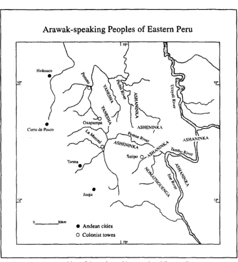
1-the Yanesha, Ashanin- ka, Asheninka and Matsiguenga of Western Amazonia- explain the origin of the present-day earth, and on how they envisage the landscape, engender a sense of place, and transform new into »traditional« territories (see Figure I).
Southern Arawaks anchor their sense of place in mythical narrations that, though different in content and details, are very similar in concept. These narra- tives are what Rumsey and Weiner'\ on the basis of their analysis of landscape notions in aboriginal Australia and Papua New Guinea, call »emplaced myths;«
namely, myths associated to the landscape, which confer meaning to particular landmarks and are rendered meaningful by the ritual practices surrounding these landmarks. According to these narratives, the nondescript, shapeless space of presocial times was transformed into the present-day differentiated and marked territories through the extraordinary activities of traveling creator gods and goddesses. Southern Arawaks maintain alive the memory of the sacred origin of their landscape through a variety of landscape ritual practices, among which emplaced myths and place rituals -both personal and collective- play a central role. Most importantly, they have enriched their sense of space through the constant incorporation of new historical agents, processes and events into their landscape narratives and practices. Far from being congealed in time - museum pieces in need of preservation - Arawakan sacred landscapes are cultural processes and, as such, are continually under construction.
Santos-Granero 1WH
The Southern Arawak cluster is composed of six groups -namely, the Yanesha.
Ashaninka, Asheninka. Matsiguenga, Nomatsiguenga. and Yine. formerly known as Piro - located on the eastern slopes of the Central Andes of Peru. 1 refer to these groups as Southern Arawak in contradistinction to the Northern Arawak of the Ori- noco and Negro river basins. For the purposes of this chapter 1 restrict the label South- ern Arawak to the Yanesha, Ashaninka. Asheninka and Matsiguenga
Rumsey and Weiner 2001.
Arawak-speaking Peoples of Eastern Peru
Cerro dc Pasco
# Andean cities O Colonist towns
Figure I: Map of Arawak-speaking peoples of Eastern Peru.
Drawing by Fernando Santos-Granero.
The ascent of the Yanesha solar divinity
Yanesha myth tellers say that before Yompor Ror, the present day solar divini- ty, ascended to the heavens humans, animals, plants, spirits, and gods shared this earth. They were immortal and lived together - not always harmoniously - under human form. By then, Yompor Rret, the first sun, and an evil divinity that enjoyed killing the Yanesha illuminated the sky of this earth. Out of com- passion for his creatures, Yompor Ror decided to dethrone him and become the new sun. When Yompor Ror told his siblings about his decision to ascend to
95
heaven, instead of waiting for him his siblings ran ahead/' This angered Yom- por Ror, making him lose control of himself and triggering his transformative powers. The many events that took place along his journey to Cheporepen, the mountain from where he was to ascend to the heavens, are recounted in at least twelve myths that I recorded from at least four different myth tellers.
In the valley of Eneflas, the traveling god found out that his sister/wife Yachor Coc, Our Mother Coca, had deceived him with Yompor Huar.'4 Angered by her infidelity, Ror dismembered his wife's body and scattered her body parts in all directions. From them, they say, grew the coca bushes whose leaves the Yanesha consume nowadays. While fighting with Huar they burnt the hillsides of the lower Eneflas valley, scorching the forest cover and giving way to the appearance of extensive grasslands. From here, Yompor Ror went on to the Chorobamba valley.
On his way he met various powerful spirits (mellanoten) and primordial human forms of animals and plants, and transformed them into the animals an evil spirits that Yaneshas know today. The streams in which these events took place are na- med after these primordial beings.
Along the way to meet his brothers and sisters. Yompor Ror also met several primordial Yanesha whom he punished for failing to display the moral virtues he extolled. He transformed a man who did not want to share with him the chemuer'' and smoked fish he had fished downriver, and a group of travelers who refused to give him some of the brightly plumed parrots they had captured. Their figures can be seen today in the white cliffs of sharply cut mountains. He also transformed two men, who were selfishly herding down-river all the aquatic and terrestrial beings that he had created for his human creatures to sustain themselves after he depar- ted from this earth. Their crouching figures can be seen as large rolling stones along the banks of the Chorobamba River. Unfortunately, we are told, Yompor Ror got there too late, when most of the fish and edible terrestrial animals had already left; this is why this area is nowadays poor in fish and game.
Yanesha sages say that when Yompor Ror met his older siblings he was very angry. He picked a fight with Yompor Yompere. transforming him together with his sister/wife Yachor Mamas. Our Mother Manioc Beer, and two other minor divinities into stones. He transformed his brother Yompor Yompuer into a small Yompor Ror and his sister Yachor Arrorr. Our Mother Moon, were the youngest of a set of four pairs of divine siblings, brothers/sisters who were married to each other.
This notion seems to have been borrowed from the Inca foundational myth of the Avar brothers and their sisters/wives. Yanesha sages disagree as to the names and combina- tions of the four pairs of siblings. A similar notion, linked to the mythical occupation of their territory, is found among the Matsiguenga (see Renard-Casevttz 2002).
In this version, Yachor Coc appears as sister/wife of Yompor Ror rather than of his brother Yompor Etetar (see footnote 54).
Very bitter bindweed that, chewed together with coca leaves and lime, sweetens the mixture.
polished stone - that would later be stolen by the white people. Further on, in Cheporepen, he battled with Yompor Etetar. During their mighty struggle they burned all the surrounding hills; this is why, myth tellers explain, nowadays they are covered only with tall grass. It was thus, Yanesha myth tellers conclude, that this earth acquired its present shape.
The misdeeds of the Ashaninka/Asheninka trickster god
In ancient times, Ashaninka and Asheninka elders narrate, humans, animals, plants, good and evil spirits, lesser and greater gods lived together in this earth under human guise. This period ended partly as a result of the malicious actions of Avireri, the wicked trickster god.'" The following account of Avireri's deeds and misdeeds is based on a version of his saga recorded by Gerald Weiss" from Shan'ti, an Ashaninka elder. According to Sharfti, when living in this earth Avireri liked to visit his sisters. In his journeys he always carried his grandson.
Kiri, on his back. Kiri was an evil child with wondrous powers who kept asking questions to his grandfather and making him angry. Avireri's ire let loose his transformative powers. Whenever they met someone, Kiri began to ask his grandfather who that person was. Avireri would answer, but Kiri would go on interrogating him, until, irritated by Kin's questions, he would utter the name of an animal and by the power of his words he transformed the person into the mentioned animal. Thus, along his many trips, Avireri transformed many pri- mordial Ashaninka men and women into the animals the Ashaninka know today.
Avireri and Kiri were also responsible for transforming the surface of the primordial earth. In one of his journeys downriver along the Tambo Avireri found a Spanish priest who was the owner of a salt spring. The stingy priest, we are told, used to whip whoever came there to extract salt. Angry with him for mistreating the Ashaninka. Avireri transformed the priest into stone. His bear- ded figure can be seen today on the face of a white cliff on the right side of the river. Together with him, Avireri transformed a small settlers' town -now visi- ble as a hill behind the cliff - and a storehouse full of merchandise -visible as a hilly protuberance to the right of the figure. Further on downriver, Avireri encountered a wharf built by white people and stacked with crates of trade Avireri appears in Yanesha mythology under the name of Ayots. Among the Yanesha, however, he and his son Poporrona' are clearly evil divinities. They have no traits of cultural heroes or ambivalent trickster gods, and they are not considered to have played a crucial role in the shaping of Yanesha landscape.
Weiss 1975: 310-343.
97
goods and rolls of cloth. To put an end to the incursions of the white men into Ashaninka territory, Avireri transformed the wharf into stone. Known as Oara- roncipanko, it can be seen as an extended rock outcrop broken into rectangular blocks. Later on, Avireri found a steam launch whose Caucasian crew was traveling upriver to molest Ashaninka women. Angered by the invaders, he transformed the launch and its crewmen into a very large rock known as Mani- hironi.
Avireri was a capricious god. One day he decided to build a dam in the Tambo River to kill all the Ashaninka. He started heaping dirt and rocks on each side of the river. But whenever he was close to finish his task, Cirarato. a small bird when it was still human, scattered the earth he had accumulated.
Angry with him, Avireri transformed him into the present day bird that the Ashaninka consider a demon. The earthworks constructed by Avireri can be seen as two hills -Kentipanko and Shironironi - facing each other at a short distance downriver from the confluence of the Ene and Perene rivers.
In one of his trips Avireri and Kiri transformed his sister's children into whi- te monkeys, arboreal termites, and bees. Angry with them for having transfor- med their children, Avireri's sister and her husband Etini. the giant armadillo when he was still human, decided to punish him. They tricked him into falling into a deep hole from which he could not come out. In the process, however, Avireri transformed his sister into the shimashiri tree, and his brother-in-law into the giant armadillo as known today. The site where this took place, a de- pression in a grass-covered ridge located in the Upper Perene region, is known as Imoro Avireri, or »Avireri's hole.« That is how, Shan'ti explained, the an- cestors of the Ashaninka put an end to the misdeeds of these two malevolent gods.
The wanderings of (he Matsiguenga Salt Lady
Matsiguenga myth tellers assert that in presocial times all beings were immortal and lived together in this earth, which itself was a powerful female divinity called Kipatsi. They all had human form. The earth acquired its present shape as a result of the activities of various tasorintsi deities -the gods that can create things by means of their divine breath. Among them the one who had the greatest impact on the primordial earth was Pareni, the salt when it still had human form. The following account of the wanderings of Salt Lady is based on three versions of her myth.'*
Pareni, Matsiguenga myth tellers assert, married several times. She was un-
'" Renard-Casevitz and Dollfus 1988: 25-28: Renard Casevitz 1994:8.95; Baer 1994: 253-258.
lucky, however, and all her marriages ended with the transformation of her husbands into present-day animals. She transformed Tsonkiri into a humming- bird, Shitati into the dung beetle, and Shiiro into the sweat bee. After these failed marriages, myth tellers assert, Pareni married Kinteroni, the primordial armadillo, who was almost as powerful as her. Their marriage was also ill fated.
Pareni had a brother, Pachakamui, who always carried on his back a small pup- pet that he had found in the forest. It was this being, called Iguiane, or The Carried One, who "made Pachakamui powerful.5' Iguiane transformed the people he encountered on his way into the animals and plants that we see to- day. He also transformed Pareni's sons into titi monkeys and her daughters into deer and tapirs. The streams where the children were transformed bear names that allude to these events. Pareni and Kinteroni decided to avenge their child- ren. Kinteroni captured Pachakamui in a hole and nailed Iguiane to the ground.
Before losing his powers, however, Iguiane transformed Kinteroni into the giant armadillo and transformed himself into the kamona palm tree.
Pareni. we are told, was desolate. She had no husband and, except for a daughter, all her human children had been turned into animals. Together with her daughter, she undertook a long journey in search for a place where she could raise her fish children. They went down the Urubamba and up the Tambo and Perene rivers, out of Matsiguenga territory and into the lands occupied by the Ashaninka and Yanesha. Wherever the traveling goddess or her daughter urinated they gave origin to salty springs, salt deposits, and salty clays -the kind that macaws and parrots like to lick. These numerous sites bear names such as Chimiato (»water of the salt pit«), Tivfha (»salt spring«), or Potiarihi (»salty water«), which recall their origin in Pareni's mythical journey.
When Pareni arrived to the Upper Perene region she transformed herself and her daughter into salt mines. At present, the ancient salt goddess can be seen as a large hill - called Pareni in Matsiguenga. Ashaninka and Asheninka - which is traversed from top to bottom by a wide vein of reddish salt. At the feet of this hill runs a river whose waters are also salty. It is called Tiviari, or Salt River, from tivi = »salt«."" Standing next to Pareni is her daughter transformed into a smaller hill that contains a vein of white salt. The Perene River, which she followed until she reached her resting place, is also named after her.
To summarize, according to the Southern Arawaks. this »mortal earth* was
The narrative of Pachakamui's and Iguiane's exploits, as recounted in the Matsiguenga myth of Pareni, is similar to the Ashaninka myth of Avireri and Kiri. According to Re- nard-Casevitz (1988: 95), this segment of the myth of Pareni is a late incorporation bor- rowed from the Ashaninka along the trading networks linking both peoples.
The Yanesha do not share the myth of Pareni. For them, the Cerro de la Sal is the self- transformed body of Posona'. or Salt Man. The larger salt hill is called Posapno, whereas the river that flows at its feet is called Posopno.
99
shaped by the words and actions of powerful traveling gods and goddesses who, out of anger or compassion for their mortal creatures, transformed the land and its beings. These mythical events, as I argue elsewhere, were » written into the landscape*."' Nowadays, Southern Arawaks can read their mythical history, as well as more recent events, in their landscape under the form of »topograms« - individual landmarks rendered mythically and historically significant through emplaced myths - and »topographs« - sequences of topograms as seen from a height, or while moving through space either along a river, a forest trail or, nowadays, a road.
Southern Arawak notions of landscape
In contrast with other Amazonian peoples who, because of their location on the heavily forested Amazon flatlands do not have the kind of ample views associa- ted with Western notions of landscape."" Southern Arawaks live in a moun- tainous environment that provides a rich variety of long-distance views. This rugged physiography in which mountain ranges alternate with river valleys of different gradient and width has given rise to a broad variety of habitats -allu- vial beaches and terraces, low and high foothills, mountaintops and plateaus- that are covered with different types of vegetation and are used for different purposes. Except for the Asheninka of the Gran Pajonal and some Matsiguenga subgroups, who are located in upland areas, most Southern Arawaks live on the richer river valleys. All, however, prefer to build their houses on high places to ensure both a good view of the access routes to their houses and an open per- spective on the surrounding landscape.
Although Southern Arawaks appreciate the sight of bluish mountain ranges fading in the distance, and of green valley bottoms shrouded in early morning mist, they do not have a word for "landscape.« They do distinguish, however, between earth in the narrow sense of »soil« (kipdtsi in Ashaninka). and earth in the broader sense of »the land surface of the world« (kamaveni in Ashaninka).
It is this latter rendition that stands for our notion of landscape in Southern Arawakan thought. There are certain important differences, however, between the Western notion of landscape and that of the Southern Arawak. In Western tradition, landscape in a strict sense of the word, refers to »a view or vista of natural scenery on land.«"' It is thus based on three assumptions. First, that landscapes are natural products; secondly, that they are composed basically of
" Santos-Granero 1998: 140-141
"Gowl997.
"' See Webster's II New Riverside Dictionary.
geological formations and, thirdly, that they are the visible part of the earth's surface.
As is apparent from the above landscape narratives. Southern Arawaks con- ceive of their landscape, not as a natural product, the result of geological fac- tors, climatic changes and evolutionary forces, but as the result of divine agen- cy. The founding acts of powerful traveling gods in primordial, presocial times are responsible for the creation of the main features of this earth."4 In social times - after the undifferentiated and unmarked world of beginnings became differentiated and human society was inaugurated - this earth continued to be reshaped through the actions of spiritual and human beings. Some divinities, powerful spirits, and demons were left behind in this earth, after the solar divi- nity ascended, and human society was established. Some of these beings are hidden and dormant, but others continue to interact with human beings in ways that affect the landscape.
In addition, new social agents have appeared in the scene. The events asso- ciated with these often-disruptive neighbors have also had a deep impact on the landscape. Southern Arawaks have incorporated some of these historical chan- ges into their mythical landscape narratives, as is the case with the references to white people and their towns, to steam launches, wharves, warehouses, and merchandise being made in the Ashaninka myth of Avireri. Other changes are acknowledged but have not yet made it into their mythology. In either case, they have left their imprint on the landscape in the form of actual buildings, ironworks, wharves, airstrips and roads or their remains: or under the guise of mystically transformed individuals and objects; or in the names attributed to historically significant places, which are generally linked to outstanding features of the landscape.
A second difference between Western and Southern Arawak notions of landscape is that for Southern Arawaks the landscape is more than the fixed geological formations that shape it. It includes the living beings that inhabit it, particularly plants, animals and humans but also, as we shall see, divinities, spirits and demons that are not visible but are known to reside in, or animate, particular sites or objects within the landscape. This way of thinking is quite apparent in the above narratives, which recount not only the genesis of parti- cular landmarks but also the creation of present day animals, humans and spi- rits. The creation of each of these beings is always linked to the appearance of a new landmark or the naming of an existing one. From the point of view of Southern Arawak thinkers, the landscape is not an inert entity but is teeming
See Wagner 1972. as well as Ramsey and Weiner 2001 for similar notions among the Australian Aborigines.
101
with life. In this holistic view, the geographical dimension of the landscape can- not be separated from its living dimension.
However, the most important difference between these two notions of land- scape is that, for Southern Arawaks. the landscape is composed not only of what can be seen but also of what common people cannot see but know that is there. Mountains and valleys, ridges and slopes, rapids and beaches, springs and streams sustain a rich variety of plants, animals, and-humans. They are also the dwelling places of a host of spiritual beings, to wit the primordial spirit owners of plants and animals, good spirits, lesser divinities and dei otiosi, all sorts of evil spirits, beings and demons, the spirits of certain dead people, and the spirits that animate a variety of features of the landscape such as rocks, fallen logs, salt springs, whirlpools and so on. Most Southern Arawaks know only a few of these places, and probably will never see these beings or their invisible »hou- ses« except, perhaps, when their souls travel in dreams. This knowledge is re- served for the few men and women who decide to embark on the search for mystical powers. By receiving proper training, herbalists, diviners, healers, shamans and priests will be able to see at will these beings, and visit their dwel- ling places deep inside the mountains, or in the bottom of rivers and lakes. Part of the sacred knowledge obtained through these mystical soul flights is passed on to lay people who can thus identify important visible landmarks, as well as the dwelling places of many spiritual beings. This process of transmission is achieved, for instance, through the singing of shamanic songs intended to heal people who have lost their souls. In these songs, the acting shaman recounts, after chewing coca leaves and licking concentrated tobacco juice, the names of all the mystical places he is visiting while in a trance as he searches for the lost soul of his patient."'
By considering the landscape as a product of divine agency, as comprised by the land and the beings that inhabit it. and as being perceived through various senses and in a variety of perceptual states. Southern Arawaks put into questi- on Western conceptualizations of landscape developed in Europe between the sixteenth and nineteenth centuries.'*
The sacredness of Arawakan landscapes
Various specialists, namely anthropologists, cultural geographers, and land- scape architects, commonly refer to the conceptualizations of landscape offered by members of small-scale or archaic societies as »sacred landscapes.« Howe-
" Santos Oranero 1984.
"* Hirsch 1997. Gell 1997, and Ingold 2000 for similar challenges
ver, we have made little effort to define what exactly we mean by »sacred« in this context. It could be argued that for Southern Arawaks the landscape is sacred because they believe it is a divine creation. It could also be contended that it is sacred because they believe the landscape to be an animated entity, both in the sense that plants, animals, objects and natural phenomena have a spiritual essence, and in the sense that certain sites are the dwelling place of extraordinary spiritual subjectivities. Although these two reasons would suffice to qualify Arawakan landscapes as sacred, I would argue that, above all, what makes them sacred is the attitude that Southern Arawaks have with respect to them; an attitude expressed in a large number of everyday personal place rituals.
Southern Arawaks do not have a word for »sacred.« But through a variety of place rituals they single out particular elements of the landscape as being sacred, that is, as imbued with powerful spiritual forces -whether good, evil or both - that can be entreated or seized, cajoled or commandeered, worshipped or exorcized." A man about to clear a garden will look for a suitable place in terms of quality of the soil, gradient of the terrain, proximity to water and so on: but he will also make sure to make offerings of coca leaves and manioc beer to the spirits of the trees he is going to cut. particularly if he encounters species of trees believed to have powerful spiritual essences. A woman in the process of planting manioc in her garden will make sure to plant a wide variety of species adapted to different soils and water regimes. She will also be careful to select healthy plants to make her manioc cuttings. In addition, however, she will sing one of various sacred songs to ensure the good will of the earth spirits, and of the primordial manioc spirit in order to obtain an abundant crop.
A fisherman sitting on the shore of a river might chew a bulb of pin-pin'* to- gether with coca leaves to obtain the aid of the water spirits guarding the parti- cular deep hole in which he plans to fish, and thus ensure a good catch. Before extracting salt or clay to make pots Southern Arawak men and women used to utter a prayer or sing a song honoring the primordial spirits of these substances, so that their powerful essences would not make them ill.
A person suffering from fever and chills might he diagnosed by a diviner as having been attacked by the spirit of a particular rock while hunting, fishing or bringing produce from the garden. In that case, the diviner identifies the parti- cular rock whose spirit was responsible for the mystical attack and instructs the patient's relatives where to find it and how to burn it. For similar reasons men Most of the landscape ritual practices described in the following paragraphs are still practiced by Southern Arawaks despite conversion to diverse Christian faiths, namely.
Evangelicalism, Adventism and Catholicism.
Piri-piri is a term that refers to a category of sedges (Cyperacea) believed to have magical properties. The bulbs of different varieties of piri-piri are used in different ways for different purposes.
": 103
and women are very careful as to where they urinate or defecate, for they might affront the spirit of a powerful plant, such as coca (Erythroxylum coca), tobacco {Nkotiana sp.), ayahuasca (Banisteriopsis caapi), or the red lupuna (Cavanitle- sia hylogeyton), and induce it to strike them with an illness. In the past, when an adult person died, his or her house was burnt: nowadays, it is frequently aban- doned, even if only temporarily, for fear that the soul of the deceased might be prowling around it.
Southern Arawaks believe that when traveling to an unknown area the spi- rits of local mountains express their displeasure with the intruders by causing heavy rains and thunderstorms. To avoid this, travelers rub some dirt on their foreheads as soon as they enter into an unknown area so that mountain spirits will believe they are locals. Shamanic apprentices undertaking their first expe- rimental soul flights to mystically powerful mountain summits, caves, waterfalls and upland lakes take all kinds of ritual precautions so as to be able to interact safely with the spiritual beings dwelling in these places.
The large number of rituals practiced that concern the interaction of persons with emplaced spiritual beings could give the false impression that Southern Arawaks are in a permanent state of fearful reverence of these potentially dangerous subjectivities. This is not so, however. Even today, after massive conversion to Christianity, the sacred is very much entangled with the profane, and is a constant dimension of everyday activities. Personal place rituals fall within the category of habitus." They are internalized forms of experience that are performed routinely and unreflexively, without much ado. The sacred is not surrounded with the kind of reverence and solemnity expected of Western religious performances. These feelings -if at all present - are reserved, as we shall see. for only a few sites of great religious significance that are the locus of more collective place rituals.
The ritual production of locality
According to Arjun Appadurai". »locality« is a central property of social life, an indispensable dimension in the engendering of ^neighborhoods* or situated communities. The reproduction of such communities requires the localization of times and spaces, as well as the production of local subjects with the know- ledge to reproduce them. Founding a new settlement demands the prior mar- king out and appropriation of a given space. It is not until the community thus situated is well settled, however, that the transformation of space into place.
' Bourdieu 1993.
' Appadurai 1996.
104 '
and the differentiation of one's own territory from that of others, is fully ac- complished. Along this process, as Keith Basso suggests, »places and their mea- nings are continually woven into the fabric of social life, anchoring it to features of the landscape and blanketing it with layers of significance that few can fail to appreciate.""
The engendering of neighborhoods always involves the creation and repro- duction of emotional links between the people and »their« land; that is, the production of locality »as a structure of feeling,« as Appadurai," following Raymond Williams,'' has postulated. Locality -or »sense of place" - is not a given. It is »an inherently fragile social achievement that requires constant collective input to reproduce and maintain.74 The production of locality, entai- ling the delineation of spaces of moral solidarity and security, is very much dependent on the need for cooperation in daily interactions; and on the creati- on of common structures of feeling. In small-scale societies, emotional attach- ment to place is generated through a variety of ritual performances. These can be grouped into rites of passage and collective place rituals.
Rites of passage are rituals concerned with the production of local subjects, that is, with the transformation of individuals into full members of their com- munity. They involve the inscription of locality on the bodies of the initiates by means of a series of complex bodily practices (seclusion, fasting, scarification, tonsure, whipping, tattoos, ablutions, and so on). Their purpose is to generate strong bonds of attachment to the collectivity and to the land. They are, thus, a means »to embody locality as well as to locate bodies in socially and spatially defined communities.""
Collective place rituals fall within the general category of landscape ritual practices mentioned above. They are. however, more directly involved in processes of place-making insofar as they have the effect of bestowing powerful meaning on specific spaces. This type of rituals includes boundary rituals, ritu- als revolving around mythical sites of origin, ceremonial reenactment of an- cestors' migrations, pilgrimages, consecration of new religious buildings and grounds, rituals of purification of the land, musical naming of places, and so on.
Through these rituals in which self, space and time become fused, the connec- tion between people as a collectivity and place is made visible, renewed and celebrated. As a result, the landscape becomes the embodied experience of the people that inhabit it. The relationship between locality and neighborhoods.
" Basso 19%: 57
,: Appadurai 1996: 181
"Williams 1977.
74 Appadurai 1996: 179
"Appadurai 1996: 179
105
peoples and places, is dialectical. Thus, in the process of fashioning places, people fashion themselves."
Southern Arawaks practice only some of the various rites of passage and place rituals mentioned above. The examination of Southern Arawak rites of passage is beyond the scope of this chapter. Here. I will only examine their collec- tive place rituals, particularly those that are or were related to places of pan- Arawak religious significance.
l-ifiiiri' 2: S'meteenth-i cnturv l-'nmciscun map nf('cm> tic la Sal.
Source: Dioni.iiu Ortiz. Chanchaniayo. I n;i Region de la Selva del Peru. uil. I (Lima: ImpreiUa y Litograh'a Salesiana. l%lM,
The sail mines of the Cerru de la Sal
The most important Southern Arawak sacred place was the Cerru de la Sal (Salt Hill), known as Pareni by Ashaninka. Asheninka and Maisiguenga. and as Posop- no by the Yanesha. The Cerro de la Sal is located in the confluence of the Posapno and Entaz rivers, shortly before the latter flows into the Paucartambo River, in the boundaries between Yanesha and Ashaninka territories (see Figure 2). It is ac- tually composed of three hills: a larger one traversed from top to bottom by a vein of reddish salt, and two smaller ones containing veins of whiter crystalline salt. At
'" Feld and Basso 19%.
the feet of the larger hill runs a small stream called Posapno, whose waters are permanently salty from the slow erosion of the hill's salt vein. Ashaninka, Ashen- inka and Matsiguenga considered the larger hill, and one of the smaller ones, to be the transformed bodies of Parent and her daughter respectively.
Yanesha conceive these hills as the body of Posona', the primordial Salt Man, who was sent to this earth by the solar divinity so that his human creatu- res could have something to season their foods with. Posona' asked the people to kill him so that he would turn into salt. When they did so, all the different kinds of salt veins that at present exist in the area appeared: some are edible like yapa pas, »agouti salt,« and ma'yarro pos, »jaguar salt«: others are harmful to humans, such as toma pos, »parrot salt.« and errasanatsa pos, »blood salt.«
The most important among the edible types -and the only one that was proces- sed into salt cakes-- was the reddish salt of the larger hill called quentot in Ya- nesha. Among the Yanesha. each type of salt is the subject of a minor mythical narrative; all together they provide a detailed classification -a mental mineral cartography as it were - of this sacred space.
The Cerro de la Sal was a dual-purpose sacred site; it was an important source of salt, but also a renowned ceremonial center. Being at the crossroads of the Amazon and the Andes, it attracted, since Precolumbian times, a multitude of highland and lowland peoples who arrived every year during the dry season - extending from June to August - to extract or trade for salt. Visitors came on foot, or they paddled in canoes up the Perene River. For some, such as the Conibo of the Ucayali River, and the Matsiguenga and Yine of the Urubamba River, the round trip could last several months. The environs of the salt mine were inhabited by Yanesha and Ashaninka. who were the only people entitled to boil the raw blocks of red salt, clean the evaporated salt, and mold it into the cakes of pure salt that were used as a kind of money throughout the region.' Other Southern Ara- waks -Yanesha and Ashaninka living farther away, as well as Matsiguenga, As- heninka. and Nomatsiguenga - had the right to extract salt blocks but not to make salt cakes. The Arawak-speaking Yine. and non-Arawakan peoples such as the Pano-speaking Conibo or the Andean peoples -who were normally enemies of the Southern Arawak - also visited the Cerro de la Sal, but could obtain salt only through trade. Yine brought freshwater pearls to exchange for the condiment, whereas Conibo brought polychrome earthenwares and painted textiles, and An- dean peoples bronze and copper ornaments and tools.
Visiting miners made offerings of coca leaves, chemiter, and limestone to the primordial salt-person, Pareni/Posona'. since they believed that extracting salt re- quired »cutting up the body« of the divinity. In addition, the salinistas or salt-
' Renard-Casevitz 21)02.
107
making specialists, performed various rituals, including fasting, vigils and sexual abstinence, to ensure the production of the finest salt cakes. Visitors settled in temporary lean-tos, on the stone beaches that appeared along the Paucartambo and Perene Rivers during the dry season. Those who came from nearby settle- ments brought their families with them; those who came from far away places arrived in male-only groups. While in the area, they took advantage of the abun- dance of salt and fish to prepare dry salted fish for their return trip. Frequently, these fishing activities were collective affairs in which several individuals or fami- lies - often from different ethnic groups - cooperated in the task of damming and poisoning with barbasco roots {Lonchocarpus nicou) a small branch of the river.
The Cerro de la Sal was also the site of an important ceremonial center in the charge of powerful priestly leaders. Early colonial documents suggest that the influence of these leaders extended way beyond the immediate geographical sphe- re of the Cerro de la Sal. A 1663 report informs us that natives extracted salt from the larger hill, and performed sacred ceremonies on the two smaller ones.7* The chronicler uses the Spanish term hiokurar, »idolize« or » worship,* to define these ceremonies, which suggests that temple rituals revolved around the sacred figures of Posona' and Pareni. These celebrations included singing, dancing and narration of sacred stories.
In 1876, when the Peruvian military invaded the region after one hundred years of isolation following the pan-Arawakan anticolonial rebellion of 1742, they found a large temple - fifteen by twelve meters in size - at the feet of the Cerro de la Sal.
Ten years later, a smaller temple -twelve by ten meters - was reported on its sum- mit. These temples, by then, were associated with ironworks, a technology that the Yanesha and Ashaninka had learned from the Spaniards in the mid-eighteenth century. ''Temple/ironworks were under the charge of priests/blacksmiths, or of blacksmiths associated to priestly leaders. Ironworks included large brick ovens where iron was extracted by heating the ore with four large bellows, as well as anvils, hammers and tongs. Elaborate rituals aimed at ensuring the production of high-quality instruments surrounded the making of iron tools - mainly axes, ma- chetes, hatchets, knives and needles. Iron was obtained from surface ore found in several places along the Paucartambo River, close to the Cerro de la Sal. The Yanesha believed that the primordial Iron Lady, Yachor Aserr. had been sent by the solar divinity for their benefit, and that she had transformed herself into iron in this region. The production of metal tools - together with the mythical narratives and rituals that surrounded it - increased even more the centrality and sacredness of the Cerro de la Sal in the Southern Arawak imaginary. Franciscan missionaries were obviously aware of the sacred character that the Cerro de la Sal had for
"Memorial 19% [1663).
7" Santos-Granero 1988.
108
Southern Arawaks; in an attempt to appropriate its power for their own evangeli- cal purposes they placed it with a cross on its summit (see Figure 2).
People visiting the Cerro de la Sal to obtain salt or iron tools participated in the ceremonies held at these temple/ironworks. Thus, during the dry season, the Cerro de la Sal became an important meeting place, where Southern Arawaks and their enemies from the lowlands (Conibo and Yine) and the highlands (Andeans), cam- ped in emergent beaches in order to meet in peace and extract salt, obtain new iron tools, repair their old ones, fish, and trade. Trading activities, fishing expediti- ons, and temple ceremonies promoted conviviality and a shared structure of fee- ling. In addition, the fact that everybody partook of the body of the primordial salt- person created a sense of consubstantiality - sharing of the same substance - and, with it. a generalized feeling that visitors were »people like us«. or »true people."*"
In short, the Cerro de la Sal provided a context where the sense of moral commu- nity could be stretched beyond ethnic boundaries, creating an interethnic sphere of peaceful, albeit temporary, exchanges. In 1897, the government assumed control of the Cerro de la Sal."' This, and the introduction of industrialized salt, gradually made the Cerro de la Sal irrelevant as a source of salt. However, although Southern Arawaks no longer extract salt from it, the Cerro de la Sal continues to be an important reference point in representations of their landscape.
The shrine of Paimaso
Palmaso. where the solar divinity transformed his brother Yompere and his family into stone according to Yanesha tradition, was also an important sacred place among Southern Arawaks. Located on the valley of Oxapampa, where the Palmaso flows into the Chorobamba River, the site is set against the im- pressive backdrop of the Andes to the West and the Yanachaga range to the East. Palmaso was an important ceremonial center and pilgrimage site that functioned from Pre-Columbian times until the early I92()'s.'" It was marked as a sacred place by the fact that no one lived there except the priestly leader (cornesha) in charge of the temple, his family and disciples. One of the grand- sons of Tsachopen, the last officiating priest of Palmaso. told me that the local temple (puerahuu) consisted of a rectangular thatched building sheltering the four stone divinities: Yompor Yompere, his wife Yachor Mamas, and his two children. A large round plaza where many of the important ceremonies were held surrounded the shrine.
'Gow2002: 153-157.
Varese 1973.
' Navarro 1924.
109
Tsachopefi made daily offerings of coca leaves, and especially of brewed manioc beer, to the stone divinities in a small altar located in an enclosure within the temple. He kept alight a sacred fire within the temple, which he claimed had appeared to him miraculously in the middle of the forest as a mate- rial manifestation of Yompor Ror, the solar divinity. The sacred fire of Palmaso was considered to be so portentous that other Yanesha and Ashaninka priests obtained permission from Tsachopefi to carry the fire and adore it in their own ceremonial centers. These offshoots of the sacred fire of Palmaso acted as a constant reminder of the shrine, serving to extend its fame throughout Southern Arawakan territories.
Tsachopefi organized periodic ceremonies in the honor of the stone divini- ties of Palmaso. These lasted several days. Pilgrims came from all parts of Ya- nesha territory to attend, but the fame of the site was so great that it also attrac- ted many Ashaninka and Asheninka from the Perene valley as far downriver as Ipoki."' Some persons came from as far away as five to six days walking. Pil- grims came in family groups; only the very old or the very young stayed behind.
Many visitors came several days in advance to help harvest the ceremonial center's gardens, procure game meat and fish, and make manioc beer. They brought with them offerings of smoked meat, dry fish, coca leaves and manioc beer, which were received by the priest, consecrated to the divinities, and. later on, distributed among all those present.
In order to enter the shrine and participate in the ceremonies, pilgrims had to comply with a series of interdictions, including sexual abstinence, prohibition of the use of foul language and fights; menstruating women were also excluded from the ceremonies. The enclosed area within the temple where offerings were laid to be mystically consumed by the divinities was off limits to everybody except to the priest, his disciples, and prepubescent children who acted as the priest's assistants. These various interdictions marked as sacred the ceremonial space and ceremonial time, the »liminal« space/time of the divinities.*
1Temple ceremonies also included daily harangues by the priestly leader on how to honor the divinities and lead a good life. Pilgrims worshipped the divini- ties by singing and dancing to the rhythm of diverse styles of coshamnats sacred music.*
5The mixed sounds of panpipes, drums, and human voices were believed to ascend to heaven and please the gods. Particularly important was the per- formance of various sacred songs whose main protagonists were the local divi- nities Yompor Yompere and Yachor Mamas. Through these songs, and the recounting of their myth of origin, the stone divinities were commemorated.
" See Weiss 1975: 272. and Santos-Granero 1W1: 285.
" Turner 1977.
" Smith 1977.
celebrated, and, as it were, brought back to life. Above all, these shared activi- ties -both secular and ritual - generated a sense of moral community and hel- ped to develop strong emotional links to the sacred place.
Attending ceremonies held in the temple of Palmaso was an important event in the life of Yanesha and Ashaninka girls and boys. Parents and grandparents instructed the children entering the temple for the first time on the importance of the site; they told them the story of the stone divinities, and admonished them about how they should behave during the ceremonies. For many young- sters, this was their first important trip beyond the limits of their local settle- ments; an opportunity to view the world and learn about their people's history as inscribed in the landscape. Once back home, recounting the stone divinities' myth of origin, and singing their sacred songs in local drinking parties, kept alive the memory of the happy days spent in the convivial atmosphere of the ceremonial center. The Palmaso center was abandoned in the early 1920's as a result of colonist encroachment and missionary pressures. However, the neigh- boring Yanesha continued whenever possible to make offerings of coca leaves, chenuter and lime to the stone divinities.
The tomb of Juan Santos Atahuallpa
Juan Santos Atahuallpa was an Andean highland mestizo trained by Jesuit priests.
In 1742, he persuaded the Southern Arawak and their neighbors to form an alli- ance with the purpose of expelling the Spaniards from their territories. Juan Santos established his headquarters in Metraro. an upland site located in the borderlands between Yanesha and Ashaninka territories, where the Franciscans had founded an important fortified mission post (see Figure 3). From this strategic place he and his allies attacked systematically Franciscan missions. Spanish cattle haciendas, and Andean frontier towns. By the end of 1742. the rebels had expelled all Spaniards from the region. Despite numerous attempts to subjugate them once more. South- ern Arawaks were able to maintain their freedom for more than one hundred years.
Ill
/•ijk'iHr.{; Juan Santos Alalmalljia and the I'rancisciin clui/wl of Mctraro. I~42.
Fragment of anonymous missionary painting. C'onvento do Santa Rosa do Ocopa. .funiii. Peru.
Juan Santos adopted elements from different religious and cultural traditions - Andean. Christian, and Amazonian - to persuade his different constituencies, namely, highland and lowland indigenous peoples. African slaves, and impover- ished Spaniards, to join him. The name/title he chose for himself. Juan Santos Atahuallpa Apuinga Guainacapae Jesus Sacramentado. expresses the hybrid na- ture of his politico-religious discourse. To attract Amazonian indigenous peoples he played on widespread messianic expectations that a savior would one day re- store humankind's lost immortality. He amply succeeded in creating a following.
and is now remembered as a divine emissary called Yompor Santo in Yanesha mythology, 'and Sacaramcntam' in Ashaninka and Asheninka mythology." In both traditions he is conceived of as a messianic figure, the son of the solar divinity -Yompor Ror among the Yanesha. Paw a among the Ashaninka and Asheninka - sent to this earth to save his mortal creatures from becoming like the despised white invaders, and to arant them immortalitv.
" Santos-Granoro I99I: NO-8.1.
*" The name Yompor Santo. Our Father Santo, derives from Juan Santos's last name, hut also seems to allude to the Espfritu Santo, or Holy Ghost. Sacaramentaro. or Sacakt- mentaro. comes from Jesus Sacramentado (Transubstantiated Jesus), one of the desig- nations of Jesus Christ that Juan Santos selected from Catholic doctrine to refer to him- self.
"" Rojas Zolezzi 1994: 58-61.
112
Yanesha myth tellers affirm that Juan Santos settled in Metraro because it was the »center of the world.« It is not clear whether the Yanesha considered Metraro to be the center of the world before his time, but it is clear that Southern Arawaks conceive of Metraro as an axis mundi, a central place that has been sacralized and re-sacralized throughout time. These same tellers assert that Juan Santos had his followers build him a large temple in Metraro, from which he taught them new ideas and practices and, above all, how to lead a ^correct Iife.« According to La Combe.vlthis temple was erected on top of the chapel that the Franciscan mission- aries had built in Metraro in 1715 (see Figure 3).
Myth tellers also say that Shellmem, his malignant classificatory brother, killed Juan Santos with a sling, out of envy. Before dying, however, Juan Santos prom- ised his followers that he would resurrect five days after his death to make them immortal. The color came back to his face several times, but he finally died for good. His followers put his body in a silver coffin, together with his silver cross and scepter. They placed the coffin in the center of his temple, where it was guarded by his disciples. From time to time, they opened the casket to see if he showed signs of coming back to life. They say his body remained as if he had just died, blood ooz- ing from the wound his classificatory brother had inflicted upon him.
La Combe, a French explorer who visited Juan Santos's »chapel,« as he called it, in 1891, described Juan Santos's tomb in the following words:
»The chapel that the Indians erected in the site of Metraro is a monument eighteen meters long by eight meters wide, supported by eight wooden pillars;
the gable roof is made of humiro palm leaves. In the center there is a mound where the body of Juan Santos used to rest: it is made of five planks of jacaran- da wood eight to ten centimeters thick, and it is a meter and twenty centimeters high; it is located in the center of the temple, whose door is oriented towards the east (my translation)""
Another explorer, who visited the site a year later confirmed the fact that Juan Santos's funeral mound was made of single planks of hardwood and was still in good shape." By then, however, the Prefect of Junin had ordered the remains of Juan Santos to be disinterred and transported to the Andean town of Tarma.";
According to Carranza. who visited the tomb with La Combe, many »Indians«
assembled every year in Metraro to commemorate Juan Santos's accomplish- ments." J.F. Pazos Varela. who also participated in the expedition, was more pre- cise, writing in 1940 that the site was the object of "periodical pilgrimages by Cam- pas and Amuesha,« that is, Ashaninka and Yanesha. Both assert that pilgrims took
"" La Combe 1905-1909 [1891]. 7:493.
'"' La Combe 1905-1909 [1891 j. 7:493.
•"Parr6 1895,2:44.
,: Carranza 1894: 1-32.
" Carranza 1894: 1-32.
113
turns to provide the dead hero with a new white cotton tunic - the Southern Arawak traditional dress -, which was laid on top of his funeral mound. This is confirmed by Yanesha oral sources asserting that pilgrims also brought the dead messiah new shoulder bags, seed chest bands, feather headdresses, and a new bow and arrows. Through both oral and documentary sources we know that close to Juan Santos's tomb there was an important temple/ironworks.^ In 1898, Re my reported that next to the ruins of Juan Santos's tomb there was »an ironworks that dated from colonial times./' The ceremonies held in honor of Juan Santos were led by the priest/smith in charge of this temple.
Oral tradition maintains that celebrations in honor of Juan Santos took place during Carnival - February or March -, which in this region corresponds to the end of the rainy season. A central event in these celebrations was sanenets, a game that, according to tradition, Juan Santos introduced when he settled in Metraro. The game consisted in having two lines of men face each other, armed with slings and hard green fruits - others say cow knee bones - that they used as projectiles. Each man shot at the man opposite him with a sling, and vice versa, while the contest- ants tried to avoid each other. It was in one of these games that, according to the myth, Shellmem killed Juan Santos. Ceremonies held at Metraro were accompa- nied by much drinking of manioc and corn beer. They also included singing and dancing to one or other of three musical styles introduced by Juan Santos - po'ne- sharetenets, ellenets and huelesheiiets - known collectively as »wet season music.«"
Celebrations taking place at Juan Santos' tomb generated a feeling of unity and common purpose among different and widely scattered peoples. They also pro- vided a formalized means to channel the conflicts and rivalries that opposed differ- ent ethnic groups and local settlements in a way that did not threaten the collectiv- ity. In addition, by recounting Juan Santos's feats and promises, the participants reinforced both, their common interests vis-a-vis the white people, and their hope for the arrival of a new messiah in the nearby future. These ceremonies came to an end with the defeat of the Southern Arawak by the Peruvian military in the last quarter of the nineteenth century, and with the subsequent disinterment of Juan Santos's remains in 1891. Today, his tomb has disintegrated: but one can still see. I have been told, the stumps of the large posts that supported it. More importantly, as we shall see below. Juan Santos continues to loom large in Southern Arawak historical consciousness.'
'" Santos-Granero 19HB: 22.
" Quoted in Ortiz 1969. 2: 429.
* Smith 1977: 120-121.
" The site of Metraro was re-sacralized in the 1920s, when an Adventist missionary. Ferdi-
nand Stahl. founded a mission close to Juan Santos's tomb. Stahl was considered by
many to be a divine emissary sent by God to save humankind. He became the center of
a transformative movement that swept the region, attracting hundreds of Yanesha,
Ashaninka and Asheninka followers (see Bodley. 1972: 220-28). The Adventist mission of
Migrations and Iterative Toponymies
Members of the Arawak language family are among the most widely dispersed indigenous peoples in South America. In 1492 they were scattered from the southern tip of Florida in the north, to the Chaco in the south, and from the eastern slopes of the Andes in the west, to the mouth of the Amazon in the east.*
Michael Heckenberger suggests that this vast Arawakan diaspora resulted from in- built sociopolitical structures that stimulated constant settlement fission and relo- cation of dissenting factions in new territories." Migrating Arawakan groups re- created a sense of place in the new territories they occupied through the replicati- on of space-structuring notions, toponymies, emplaced myths, and place rituals.""
In brief, Arawak-speaking peoples tend to reproduce their landscape wherever they go. following an ideal image deeply entrenched in their minds and practices.
The clearest expression of this mechanism of appropriation of new territories is the predominance of iterative toponymies. In reference to the riverine Ashaninka.
Weiss asserts: »Some of these proper names for tributaries of the main rivers are repeated at intervals of some distance. There is. for example, a Shaoridto on the lower Tambo and another on the upper Tambo, a Pihireni and an Anapati both on the Tambo and on the Ene. a Kempfri on the Ene and another on the Apuri- mac.'"'" France-Marie Renard-Casevitz, referring to the Southern Arawak cluster, adds: »Each subgroup makes use of the same series of toponyms differently distri- buted: a string of rapids called Moon's Fish Trap, a hill named Tobacco Sniffing Tube (in the shape of an inverted v), another hill dominating the river. Eagle's Summit, a third one, Comet Hill. etc. This series of toponyms alternate with other, more descriptive ones: Rainbow Water (spring of ferruginous water), Site Where Cocks-of-the-Rocks abound, or where fish x. palm y, or demon z abounds* (my translation). '
In general, the attribution of old toponyms to new places follows principles of analogy. Some toponyms refer to specific ecological features. Such is the case for names of the kind » place where such and such a thing abounds.* Wherever a particular plant, animal, mineral, clay, water and so on abounds the pre- existing name can be easily recalled, modified with the appropriate suffixes to indicate whether the place is a hill, a river, or a lake, and then applied. Other toponyms are linked to major or minor mythical or historical events. Most Metraro became the sacred geographic center of the movement. The overlapping of multiple historical and mythical referents - sacred or secular - in particular landmarks has been pointed out by several authors (see, especially. Joanne Rappaport, 1989:84-94).
"* Hill and Santos-Granero 2(X)2.
" Heckenberger 2002.
""' See Vidal 1987. Hill 1993. Renard-Casevitz, 1993. and Zucchi 2002.
"" Weiss 1975: 248.
'"' Renard-Casevitz 1993: 27.
115
generally, these toponyms are associated with features of the landscape that have particular shapes: a rock that suggests the form of a crouching bathing woman, or of crates of merchandise; or the face of a cliff where the shape of a person can be discerned. It can also be a rock projection in the shape of a nest, as exemplified by two high cliffs on the banks of the Ene and Perene rivers respectively, both of which are named Pakicapanko (Hawk's House), and are associated with the same myth of a man-eating hawk."" In the same vein, the Ashaninka have applied the name Otika (meaning »dam«) to various passes along the Tambo and Ene rivers where the river narrows dangerously, or large rocks obstruct passage, linking these places to the mythical times when Avireri attempted to dam a large river in order to flood the earth and wipe out human- kind.""
The use of old toponyms to name new places is an old strategy used by colo- nizers all over the world. Spanish, Dutch, French and British settlers in North America used old toponyms associated with biblical sites (Philadelphia, Bet- hany), European cities (York, Orleans), patron saints (San Francisco. St. Lou- is), and Christian doctrine (Sacramento, Corpus Christ!) to name the new towns they founded and, thus, to legitimate their presence. The iteration of toponyms among the Southern Arawak not only legitimized the occupation of new terri- tories but, above all, created a sense of continuity in the face of constant geo- graphical movement. In other words, it contributed to the recreation of affecti- ve connections to the landscape and the engendering of a sense of place. These processes go so much back in time that present-day Southern Arawaks would not recognize such replication as the result of the conscious geopolitical strate- gies of their ancestors. On the contrary, each Southern Arawak sub-group sha- ring places with similar names would argue that theirs is the place where this or that mythical event »really« took place. It is through this certainty that affective connections to one's territory are maintained and reproduced.
Southern Arawak landscape today
Do these affective connections still persist? Is the landscape still sacred for the Southern Arawak? One would suspect that Southern Arawak perceptions of land- scape would have changed radically as a result of displacement from parts of their ancestral lands, fragmentation of their territory into »native communities/; adopti- on of formal education, conversion to Christianity, and the appearance of new
»modern« landmarks. However, this is not quite so.
Weiss 1975: 409-411.
Weiss 1975: 248.
In August of 2000, I asked Benjamin Pango."" an Ashaninka bilingual teacher, to draw me a map indicating the route to the town of Metraro, which I wanted to visit. The map he drew (see Figure 4) did not follow the conventions of Western cartography, but rather depicted the landscape as seen from a horizontal perspec- tive. It included various geographic formations, such as mountain ranges (San Carlos in the forefront, the Andes in the back) and rivers (Perene, Eneno, Mapini- ni and Vayos), as well as various man-made features, such as roads (Yurinaki-San Juan), bridges (Yurinaki bridge over the Perene River), settlers' towns (Coopera- tiva Cahuide. Villa Patria. San Juan, and Metraro). and native communities (San- cachari and Mariscal Caceres). More surprisingly, however, was the fact that Ben- jamin incorporated into the map several mythical landmarks of local significance.
\
.^
Figure 4: Map depiaini; route to settler town of Metraro. 2(H)th Drawing by Benjamin Pango.
The most important is »Abireri y sus piedras.« (Avireri and his stones), the site where the Ashaninka trickster god Avireri transformed several tasorintsi spirits into stone. This place is close to Imoro Avireri. -Avireri's hole,« where Ashaninka myth tellers assert thai Avireri's angry sister trapped the trickster god to punish him for having transformed her children into animals. The second site. Kentyokiri Marenkama. is a small lake inhabited, it is said, by powerful water spirits, who.
This is a fictious name in accordance with anthropological conventions to protect the identity of informants.
117
from time to time, appear to Arawak travelers to seduce them and carry them into their underwater spiritual houses. The third site, the »Pajonal de Apinca,« (Apin- ca's grassland) is a large extension of grasslands that served as the setting for many of the feats performed by Juan Santos Atahuallpa, the divine emissary. Api'nca derives from Apuinga, or Apu Inca, words that can be translated as »Great Inca,«
one of the many titles used by the eighteenth-century highland mestizo hero. Last but not least, Benjamin included Metraro, not only to indicate the small settler town that bears this name nowadays, but as an "explicit reference to the site of Juan Santos's tomb.
Why did Benjamin, an Ashaninka professional who has been brought up as a Christian and is very much acquainted with the ways of the global world, include these mythical landmarks in a map meant for a non-Ashaninka? It could be argued that he did so because the national education project he works for places great emphasis in the preservation of so-called "traditional knowledge.« Alternatively, he could have done so because he knows that anthropologists like me appreciate this kind of information. It could also be related to the fact that he drew the map for me in the context of a workshop in which f was advising him and a group of other native and non-native teachers on how to incorporate indigenous historical knowledge into the teaching of national Peruvian history at elementary school level. All these factors might be part of the explanation.
I would argue, however, that the main reason why Benjamin incorporated these mythical landmarks into his map is because they are still significant to him, as they are to many other Southern Arawaks, both as »road signals* - signs used to find one's way in a given space - and as local monuments - reminders of past Southern Arawak history. I cannot recall a single trip with Yanesha or Ashaninka compani- ons - whether on foot, canoe, motorboat, truck, or pickup - in which they did not call attention to some or other landscape feature, and recount the mythical, histo- rical, or personal meaning that it had for them.""
Southern Arawaks acquire knowledge about these landmarks, and the empla- ced myths that go with them, since they are children. They first learn about those features that are visible from where they live. Later on, when they start traveling short distances, they learn about the landmarks that can be seen in the region where they live - generally a small valley or river segment. As they become adults and travel more often, they learn about the landmarks in other regions within their territory, and even about landmarks in the territories of neighboring peoples.
Southern Arawaks - men more than women - travel very often. In the past, men traveled to find a wife, to extract salt from the Cerro de la Sal, to visit their ayom- pare trading partners, to train with a master shaman or priest, or to raid their ene-
See SantoS-Granero 1998:128-130, for an example of such a trip.