Ali Werwer, chairman and CEO of Research Groundwater Co., (REGWA), Cairo; and Professor Dr. John Sandy, director of the Rodgers Library for Science and Engineering, University of Alabama; and to Mr.
Historical Aspect
Petroleum Occurrence and Chemical Composition
Properties of Crude Oils
Natural Gas—Definition
Petroleum Hydrocarbon Non-Reservoir Rocks
Petroleum Reservoir Rocks
Petroleum Migration and Accumulation
- Introduction
- Oil Migration
- The Role of Connate Water
- Differential Entrapment of Petroleum Hydrocarbons—
- Petroleum Accumulation
The interstitial water content of reservoir rocks generally exhibits a hydrodynamic fluid pressure gradient and moves toward lower fluid potential; rate varies with size. Trap characteristics vary widely and may occur due to structural or stratigraphic factors or a combination of both.

The Capacity of Oil and Gas Traps
Leaks of hydrocarbons from accumulations are called seeps or shows and occur either from the exposure of reservoir rock as a result of erosion, or from a buried reservoir rock facing "permeable". Fluid pressures within the reservoir rock can also fluctuate over the lifetime of the reservoir, depending on the geologic history of the region, and can range from one atmosphere to 1,000 atmospheres.
Petroleum Province—Definition
Scope
Continental Shelves
Plate Interactions
Examples of continental collisions where one continental margin has a marginal arc and trench system and the other a rifted margin sedimentary prism (Dickinson 1974). There are three basic causes of subsidence or uplift as a result of plate interaction: (1) changes in crustal thickness; (2) thermal expansion or contraction of the lithosphere; and (3) widespread bending of lithospheric plates in response to local tectonic or sedimentary loading.
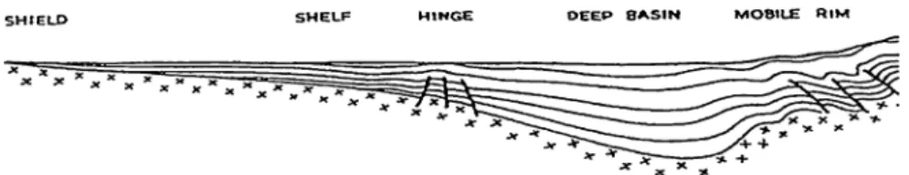
Development of Sedimentary Basins
Geodynamic Settings of Sedimentary Basins
Basins of rifted environments, in which tectonic evolution is dominated by extensional plate movements and crustal faulting, and those of orogenic environments, in which tectonic evolution is dominated by contractional plate movements and orogenic deformation, include several idealized subgroups. Oceanic basins frequently evolve from emergent phases dominated by extensional tectonics into remnant phases dominated by contractional tectonics.
Sedimentary Basins and Hydrocarbon Occurrences
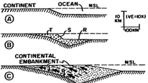
16 2 Sedimentary basins and plate tectonics Fig. vertical exaggeration 10X) to illustrate sedimentary basins associated with intraoceanic (top) and continental margin (bottom) magmatic arcs. Plate interactions fully explain the causes of subsidence, the sequence of depositional events, the development of structural features and the timing of thermal flux - all of which in turn can explain conditions in the geological record of sedimentary basins (Dickenson 1981).
Oil Migration and Subduction
Rifted-Margin Sediment Prisms
The rising prism of rifted-margin sediment imposes sufficient load on the lithosphere near the interface between old continental and young oceanic crust to induce flexural collapse of the lithosphere (Fig. 2.9, Walcott 1972). The type of rift margin sediment prism developed by bulk sedimentary progradation of the continental margin is aptly called a continental embankment (Dietz 1963).
Introduction
Magnetic Survey
Gravimetric Survey
Seismic Exploration Survey
General
Seismic Refraction Methods
Seismic Reflection Method
A modeling process allows accurate interpretation of these features, eg, drilled diapirs, salt dome structures at different stages of development, and associated geological phenomena, thereby increasing success in drilling for hydrocarbon reserves.
Land-Satellite Images in Salt Dome Exploration
Introduction
The effect of the hydrodynamic conditions can be extremely important for the movement of the petroleum. Should the reservoir rock be tilted, there will be a greater chance of another migration (a tertiary migration), because the buoyancy factor will be increased due to the overall height of the oil or gas masses.
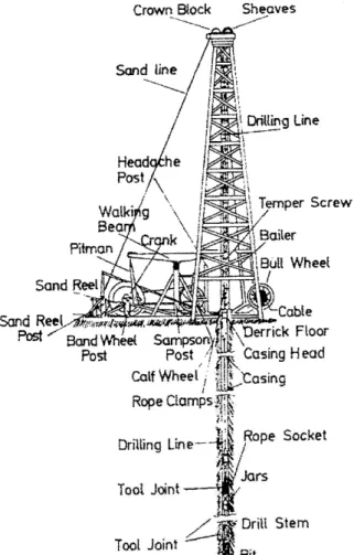
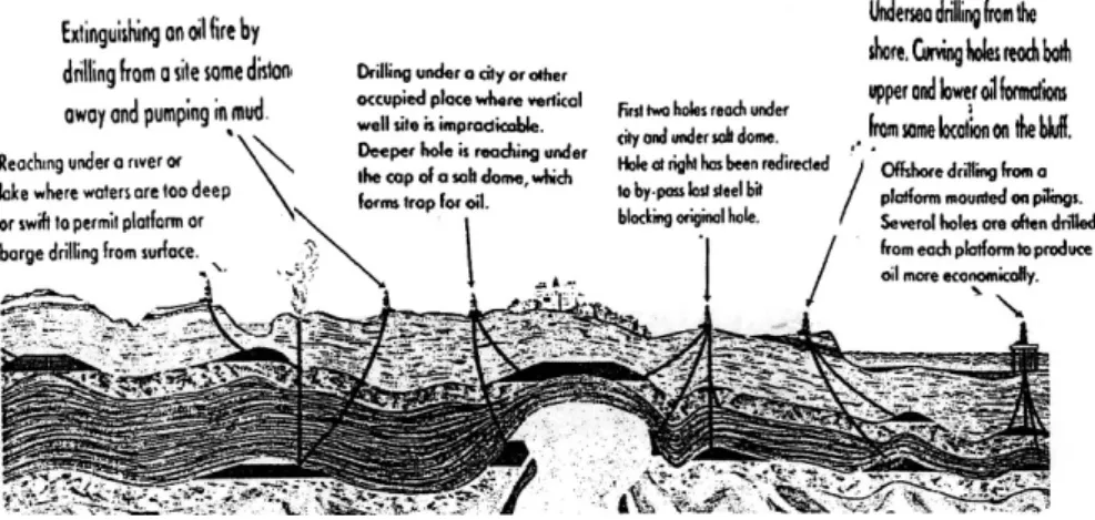
Petroleum Drilling Operations
Discussion
Used in shallow to moderately deep wells where a small lateral displacement is required and where intermediate pipes are not expected. Used in wells where intermediate casing is set to protect against problem zones and to achieve uniform bottomhole spacing (modified from Cook, 1957).
Types of Drilling Operations
Used for show deflections in multi-pay fields where multiple completions are not desired and to determine the size and structural position of the reservoir.
Drilling Fluids
- Properties of Drilling Muds
- Composition and Nature of the Drilling Fluids
- Mud Systems in Salt Structures
- Salt Dome Drilling
Salt water muds are used when drilling through salt beds and in areas where there is a lot of salt water (eg offshore drilling and in marshes and by the sea). Problems of drilling deep wells in or above salt structures include lost circulation, shale upwelling, saltwater flows, zones of abnormally high pressure and high temperatures.
Drilling Hazards
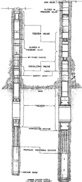
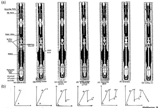
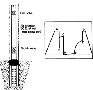
Drill Stem Testing (DST)
Scope
A hydraulic reservoir is attached below the test valve to increase the pressure to 8 psi, to release the packing after the test. An equalizing bypass valve to allow mud pressure equalization across the packing(s) into and out of the DST assembly after completion of the flow test.
Discussion
Both measurements make it possible to accurately determine whether or not the perforations became clogged during the test. A perforated anchor is an extension below the tool that supports the weight used to set the packer.
General Remarks
About the DST—Procedure
A water cushion of a certain length or fluid head is placed inside the drill pipe instead of drying out, to reduce the external pressure in the drill pipe in deep holes and/or to reduce the pressure drop in the formation. and across the packager(s) when the DST assembly is first opened. The length of the DST is highly dependent on several observations during the test; eg, in tight formations, the drill pipe cannot be stuck and the flow test often takes several hours; closing period.
Required Conditions and Reasons for Carrying Out a
Edwards AG and Winn RH (1974) A summary of modern tools and techniques used in drill spindle testing; presented at the inauguration of the American East-West Trade Center. Edwards SH and Miller CP (1939) Discussion of the effect of combined longitudinal loading and external pressure on the strength of oil well casing.

Introduction
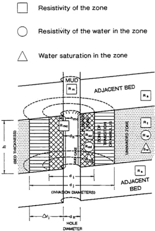
Borehole Parameters and Rock Properties
Mud filtrate (Rmf) is the fluid from the drilling mud that infiltrates into the formation during penetration, while the solid particles of clay minerals are trapped at the side of the borehole and form the mud cake (Rmc). The depth of penetration of the mud filtrate into the invaded zone is referred to as the diameter of penetration "di and dj" and depends on the permeability of the mud cake and not on the porosity of the rock (Fig. 5.1; Schlumberger 1977, AAPG 1982).
Resistivity Measurements by Well Electric Logs
Definition
Annulus and Resistivity Profiles—Hydrocarbon Zone
In freshwater mud, the resistivity of both the mud filtrate (Rmf) and the residual hydrocarbons (Rh) is much greater than that of the formation water (Rw); therefore the resistivity profile is built up where the shallow flushed zone (Rxo) is relatively high (the flushed zone has both mud filtrate (Rxo) and some residual hydrocarbons (Rh). In saltwater mud: due to the mud filtrate resistivity (Rmf) being approximately equal to the resistivity of the formation water (Rmf ~ Rw), and the amount of residual hydrocarbons (Rh) is low, then the resistivity of the flushed zone (Rxo) is low.
Formation Temperature (T f )
44 5 Geophysical methods of logging wells of oil and gas reservoirs Fig. 1) In freshwater mud - the resistance of the mud filtrate (Rmf) and residual hydrocarbons (Rh) is much greater than that of the formation water (Rw); Therefore, the resistivity profile is built where the shallow flushed zone (Rxo) is relatively high (the flushed zone has both mud filters (Rxo) and some residual hydrocarbons (Rh). Since more hydrocarbons are mixed with the mud filters in Occupied area, the resistance of the occupied area (Ri) begins to increase.
Specific Log Types
- Spontaneous Potential Logs (SP)
- Resistivity Logs (R)
- Porosity Logs
- Gamma Ray Logs
The interval transit time (t) of a formation is increased due to the presence of hydrocarbons (i.e., the hydrocarbon effect). Formation bulk density "ρb" is a function of matrix density, porosity and the density of the fluid in the pores (salt mud, fresh mud or hydrocarbons).

Well Design and Well Type Completions
Scope
Open Hole Completions
Perforated Completions
Screening Techniques
Other Type Well Completions
Introduction
Aspect
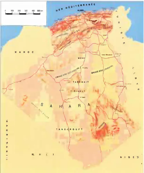
The North African countries include Egypt to the east, Libya to the west, and the Arab Maghreb to the northwest, which includes Morocco, Algeria, and Tunisia (Fig. 6.1; Michel, 1969, AAPG 1970). Egypt has been called the "Gift of the Nile", yet the Nile Valley is one of the poorest regions in North Africa, although it contains mineral resources such as iron phosphates, gypsum, salt and potash.
Petroleum Perspective
Sediments were deposited first in the troughs, and then over the entire pre-Cretaceous land surface. As in the northern Sahara, many of these reservoirs are located on elevations, structural elevations or their edges.
Geology of Algeria
- Tectonic History
- Structural Geology of Algeria
- Geologic Provinces of the Algerian Sahara
- An Approach to a Computerized Lithostratigraphic Chart
- Stratigraphy of the Algerian Saharan Platform
- A Geological Study of An Exploratory Well at the
More than one common petroleum system may exist in each of the basins in the Grand Erg/Ahnet province. The province includes the Melrhir Basin, the Ghadames (Berkine) Basin and part of the Oued M'ya Basin.
Petroleum Geology of the Libyan Sahara
Scope
72 6 A lithostratigraphic correlation plot – A model type/the upper rock units of North Africa are related to the middle and. The Carboniferous section in the Illizi basin (the Lower Tournaiian stage to the Upper Stephenian stage) was classified according to palynological studies; the series of petroleum reservoirs D6-D8 are related to the Upper Tournai stage.
Stratigraphy of Sebha Area West of Libya
The Awenat Wennin Formation (Middle-Upper Devonian) in the Libyan territory is comparable to the Frasinian-Givitian of the Sahara Platform. Strunian-Tournasian: The Mrar and Assed Jefar formations in the Libyan territory are comparable to the Upper Devonian-Lower Carboniferous formations (Strunian-Tournasian) of the Algerian Sahara platform.
Petroleum Geology of Egypt, Northeast Africa
- The Western Desert of Egypt
- Geological Results of the Petroleum Exploration
- The Nile Delta of Egypt
- The Gulf of Suez Region, Egypt
Oil may be trapped in structural highs of Lower Eocene fractured limestone. The Nile Delta represents a consequence of the conflict between the Nile River and the Mediterranean Sea.
Economic Aspects of Salt Structures
The Rudies formation produces oil at the Balayim onshore and offshore oil fields and the Feiran and Kareem oil fields. Etudes du Cycle Salif'ere (texts and plates). 1981) Geological Investigations of the Triassic Condensate and Gas Reservoir at the Hassi R'Mel Field (Internal Report, Sonatrach).
Scope
The Petrodata System
Historical Aspect
Classification of the Petrodata System
A well identification catalog number is an essential tool of the Petrodata system to define the location. Field (2) defines the well location in a specific basin of the area encountered and is displayed in six numerical digits: the first indicates the north (3) or south (4) of the area.
Economic Aspects
Recommendation
A Type Computerized Montage Drilling Report of an Exploratory
Appendix A
The theory proposes a model of the Earth's upper layer, where the colder, brittle surface rocks form a shell (the lithosphere) overlying a much less rigid asthenosphere. Plate margin (Plate Boundary) - The boundary of one of the plates that form the upper layer (the lithosphere) and which together cover the Earth's surface.
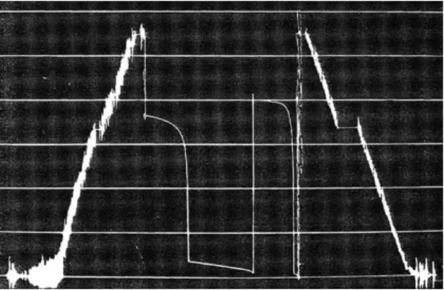
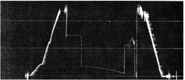
A recorder of stair stepping (Enregistreur: stair stepping)
Incorrect base line and plugging during flow (Ligne de base incorrecte
Clock stopped (Arrˆet de la montre)
Swapping (Pistonage)
Plugged formation through flow testing (D´ebit bouch´e)
Equalized flow (FSIP = FFP) (D´ebit ´egalis´e)
The after flow pressure conceals ISIP (Courbe en “S” d´evellope par
Flowing in leads (D`ebit en coup)
Bottom pressure measurement show plugging of perforations
A Diagram Shows the Invasion of Fluids through the Surrounding
Resistivity Profile- Hydrocarbon Zone (AAPG, 1982)
SP deflection with resistivity of the mud filtrate much greater than
Dual induction focused log curves through a hydrocarbon-bearing zone
Dual Laterolog-Microspherically Focused Log (MSFL) curves
A genaralized lithology logging with combination Gama Ray
A sketch diagram of an open hole completion in a productive oil well
Method of plotting screen analysis data. Note that four sands shown
North africa geology and oil and gas fields. (Michel 1969, AAPG 1970) . 57
Natural boundaries of algiers and morphological zones
Old and recent classifications of lower liassic/triassic formations in ne
Regional structural map of the Algerian Sahara
Location map of well Ry-1 and cross section
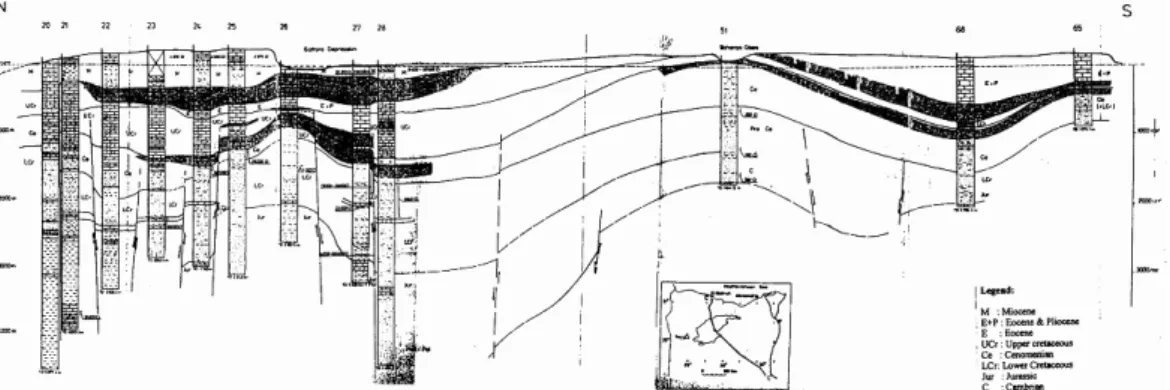
Cross section in Berkine basin (After N. Goucem, Sonatrach, 2000)
Location map of Sebha Area, Libya
Location of El-Razak and Abu Gharadig Oil and gas fields, northwest
A geological map of Bahariya Oases, Western Desert, Egypt (Ball and
Generalized Cross Section: Mersa Matruh – Qattara Depression –
Location of Assiut-Kharga Well, Egypt
Geological profile through the area including Assiut-Kharga well Nakb
Generalized hydrocarbon-bearing litostratigrapic column of the Nile
A Location Map of Gulf of Suez showing the Morgan Oil Field and the
A structural cross section across the line C-C (see Fig. 6.17/location
A simplified Lithostratigraphic Log in Morgan Oil, Field (Metwalli
Flow diagram – petrodata system
A key map for the proposed Boumahni well (BI-1), NE of the Saharan
A structural cross section passing by Ga-1 and HK-1 and the proposed
A composite lithologic well log and the design of Casings of the
A lithostratigraphic correlation chart of Sedimentary Section –
Comparison of the sedimentary section west of the Libyan and northeast of the Algerian Sahara. North of the depression, a limestone plateau (500 m above sea level) extends to the Farafra and Bahariya depressions.
A composite log of Bahariya well # 1
Assiut-Kharga composite well log
Operations Flowchart Petrodata Data Base Maintenance
- Sonic velocities and interval transit times for different matrices used in
- Matrix densities of common lithologies used in the Density Porosity
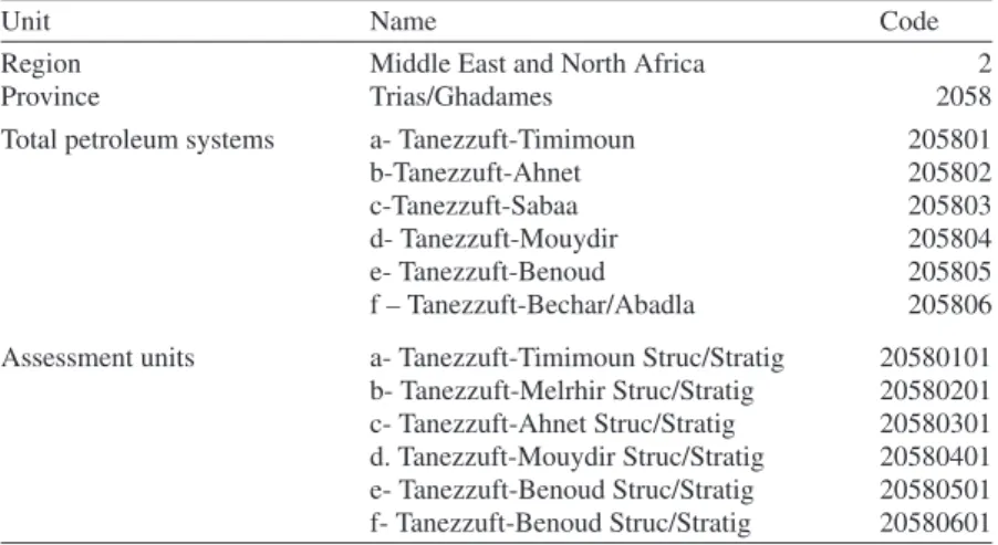
- A numeric code applied for the Grand Erg/Ahnet Province, Algeria,
- A numeric code for the region, province, total petroleum systems, and
- A numeric code for the region, province, total petroleum systems, and
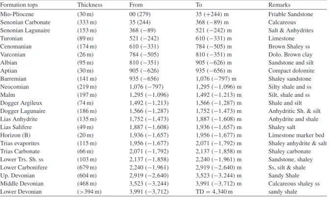
- General well data of the well Rhourde Yacoub (Ry-1)
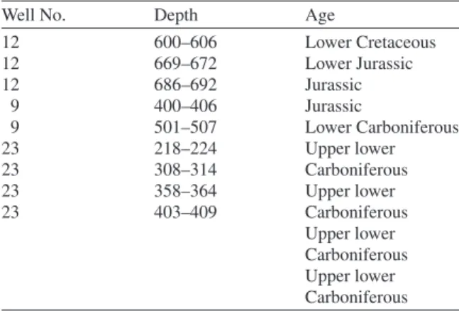
- Formation tops from micropalaeontogical results in some wells at
- Stratigraphical units in Assiut-Kharga well
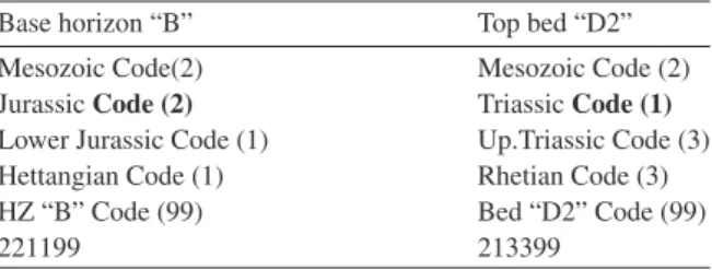
- Formation coding system
- The six-digit numeric code of a stratigraphic level of a bed
- Tabulating cards file
- a General Well Data (Card Types 1, 2 & 3)
- b Formation and Lithology Data (Card Types 08, 35 and 36)
- A comparison table showing different formations encountered at BI-1,
The positions of some present-day plate boundaries are disputed, especially within and adjacent to collision zones, e.g. the Alpine-Himalayan belt. Many features of Earth's history are explicable within this model, which has served as a unifying hypothesis for most of the Earth sciences.