Geological Society, London, Special Publications
doi: 10.1144/SP355.9 p177-202.
2011, v.355;
Geological Society, London, Special Publications
M. A. Cottam, R. Hall, M. A. Forster and M. K. Boudagher-Fadel Togian Islands
Bay, Sulawesi, Indonesia: new observations from the Basement character and basin formation in Gorontalo
service Email alerting
new articles cite this article
to receive free e-mail alerts when here
click
request Permission
part of this article
to seek permission to re-use all or here
click
Subscribe
Collection
London, Special Publications or the Lyell to subscribe to Geological Society, here
click
Notes
© The Geological Society of London 2014
at University of Aberdeen on April 28, 2014 http://sp.lyellcollection.org/
Downloaded from http://sp.lyellcollection.org/ at University of Aberdeen on April 28, 2014 Downloaded from
Basement character and basin formation in Gorontalo Bay, Sulawesi, Indonesia: new observations from the Togian Islands
M. A. COTTAM1*, R. HALL1, M. A. FORSTER2& M. K. BOUDAGHER-FADEL3
1SE Asia Research Group, Department of Earth Sciences, Royal Holloway University of London, Egham, Surrey, UK
2Department of Earth Sciences, Australian National University, Canberra, ACT, 0200, Australia
3Department of Earth Sciences, University College London, London, UK
*Corresponding author (e-mail: [email protected])
Abstract: We present a new stratigraphy for the Togian Islands, Sulawesi, and interpret the age, character and evolution of Gorontalo Bay. At its western end the bay is underlain by continental crust. The central part is underlain by Eocene to Miocene oceanic and arc rocks, although the area south of the Togian Islands could have continental crust of the Banggai-Sula microcontinent thrust beneath this and the East Arm ophiolite. Gorontalo Bay was not a significant deep bathy- metric feature before the Miocene. Field relationships indicate a latest Miocene to Pliocene age for inception of the basin. Medium-K to shoshonitic volcanism in the Togian Islands is not due to subduction but reflects crustal thinning and extension in the Pliocene and Pleistocene, causing the underlying mantle to rise, decompress and melt. Extension is continuing today and is probably the cause of volcanism at Una-Una. Volcanic activity migrated west with time and volcanic pro- ducts have been offset by dextral strike-slip displacement along the Balantak Fault. Extension and subsidence was driven by rollback of the subduction hinge at the North Sulawesi Trench with a possible contribution due to flow of the lower crust.
Gorontalo Bay is one of the most enigmatic basins in East Indonesia. It is relatively deep with water depths up to 2000 m, and Hamilton (1979) showed up to five kilometres of sediment in its western depocentre. It is surrounded by land on three sides and receives large volumes of sediment from nearby mountains up to three kilometres high.
Miocene carbonates are widespread in these areas (van Leeuwen & Muhardjo 2005) and suggest that the deep basin formed since their deposition but the timing and mechanism of basin inception remain unclear.
The nature and age of the crust beneath Gorontalo Bay is also unknown. To the north, the North Arm of Sulawesi is interpreted as a volcanic arc built on Eocene oceanic crust (Taylor & van Leeuwen 1980; Elburg et al.2003; van Leeuwen
& Muhardjo 2005). In contrast, at the western end of Gorontalo Bay, there are two kilometre high mountains with young metamorphic ages and evi- dence of continental crust, Miocene extension and core complex formation (Sukamto 1973; Elburg et al.2003; van Leeuwenet al.2007). To the south, the East Arm of Sulawesi comprises ophiolitic rocks of the East Sulawesi Ophiolite (Simandjuntak 1986;
Monnieret al.1995; Bergmanet al.1996; Parkinson 1998; Kadarusmanet al.2004). Silveret al.(1983b) suggested that Gorontalo Bay was a fore-arc basin,
underlain by ophiolitic crust equivalent to the East Arm ophiolite, situated in front of the North Arm volcanic arc that has been thrust south onto the Banggai-Sula microcontinent.
The Togian Islands, situated in the centre of Gorontalo Bay (Fig. 1), offer a unique opportunity to investigate aspects of the basin’s origin and evol- ution. The archipelago forms a broadly WSW – ENE trending ridge that continues to the west as a sub- marine feature. Geological maps of the islands show igneous rocks and contrasting interpretations of them. Ku¨ndig (1956) reported andesitic intrusive rocks in the central islands, and older ophiolitic rocks in the eastern islands – suggesting a possible link to the East Sulawesi Ophiolite. In contrast, Rusmana et al. (1982) reported widespread tuffs and sedimentary formations of Mio-Pliocene age.
The volcanic rocks could therefore be part of the ophiolite, could form part of the North Arm volcanic arc, or could be subduction-related products that predate the collision (Garrardet al. 1988; Davies 1990) of the Banggai-Sula microcontinent with the East Arm.
The Togian Islands are also close to the isolated active volcano of Una-Una, just NW of the Togian archipelago, which has a K-rich chemistry and erupted violently in 1983 (Katiliet al.1963; Katili
& Sudradjat 1984). It is not a typical subduction From: Hall, R., Cottam, M. A. & Wilson, M. E. J. (eds)The SE Asian Gateway: History and Tectonics
of the Australia– Asia Collision. Geological Society, London, Special Publications,355, 177 – 202.
DOI: 10.1144/SP355.9 0305-8719/11/$15.00#The Geological Society of London 2011.
volcano in position (about 200 km above the Benioff zone) and, if related to this subduction, is unusual in being the only volcano.
We present a stratigraphy for the Togian Islands based on new field observations and dating. In many cases dating was restricted by the intense tropical weathering typical of SE Asia, and/or a lack of datable material. We combine these new data with earlier studies and observations of the physio- graphy, bathymetry and seismicity of the northern Sulawesi region, to elucidate the Cenozoic history of Gorontalo Bay.
Tectonic setting
Sulawesi comprises a complex association of mag- matic arcs, metamorphic rocks (varying in grade from low to high), ophiolites and microcontinental fragments that have been variously assembled and deformed during the Late Mesozoic and Cenozoic (e.g. Audley-Charles 1974; Hamilton 1979; Hall 2002). It has been subdivided into four tectonostra- tigraphic terranes separated by major faults (e.g.
Hamilton 1979). The composition of the terranes surrounding the study area is described below.
Following recent studies (e.g. Calvert 2000; van Leeuwen & Muhardjo 2005; van Leeuwen et al.
2007) we do not use the term Western Sulawesi Plutono-Volcanic Arc Terrane. Instead, we follow
previous authors in separating this ‘terrane’ in to two different entities based on the recognition of significant differences in age and character of rocks (e.g. Taylor & van Leeuwen 1980; Calvert 2000; Elburg et al. 2003). We adopt the terms Western Sulawesi Province and Northern Sulawesi Province (e.g. van Leeuwen et al. 2007; see Fig. 1). The position of the boundary between these provinces remains uncertain (Elburget al.2003).
Western Sulawesi Province
The Western Sulawesi Province (Fig. 1) represents a continental margin segment (van Leeuwen et al.
2007). It has a metamorphic basement that includes the Malino and Palu Metamorphic Complexes, exposed at the NW and SW corners of Gorontalo Bay respectively (Elburget al.2003; van Leeuwen et al. 2007). These rocks form part of an arcuate zone of dismembered accretionary complexes (Parkinson 1998) and continental fragments, meta- morphosed in the mid-Cretaceous during emplace- ment along the SE margin of Sundaland by NW directed subduction (Parkinson 1998).
The basement is overlain by weakly metamor- phosed Upper Cretaceous sedimentary rocks of the Latimojong Formation, which are in turn overlain by a sequence of weakly metamorphosed Palaeo- gene sedimentary rocks and subordinate volcanic rocks belonging to the ‘Older Series’ of Elburg Fig. 1. Tectonostratigraphic provinces of Sulawesi. Modified after Hall & Wilson (2000), Calvert (2000) and van Leeuwen & Muhardjo (2005).
M. A. COTTAMET AL.
178
at University of Aberdeen on April 28, 2014 http://sp.lyellcollection.org/
Downloaded from
et al. (2003). The exact nature of the contact (depositional or faulted) is not known. Close to the study area these rocks include the Tinombo For- mation (Brouweret al.1947), fore-arc basin sedi- ments characterized by a transition from syn-rift sedimentation to platform carbonates and deeper marine sedimentation between the Late Eocene and Middle Miocene (Coffieldet al.1993; Wilson
& Bosence 1996; Calvert 2000). The contempora- neous Tinombo Formation volcanic rocks (c. 51 to 17 Ma) range from basalt to rhyolite and include dykes, volcanic piles and co-magmatic intrusive stocks (Elburget al.2003).
Intrusive and extrusive rocks of the ‘Younger Series’ (Elburg et al. 2003) include an acidic high-K calc-alkaline (CAK) suite of plutons (Kavalieris et al.1992) and comagmatic volcanic rocks (van Leeuwen et al. 1994; Elburg et al.
2003), and a high-K calc-alkaline, shoshonitic and ultra-potassic alkaline (HK) suite of dykes, small stocks and less common extrusive rocks (Elburg et al.2003).
Northern Sulawesi Province
The Northern Sulawesi Province (Fig. 1) comprises a dominantly tholeiitic Tertiary volcanic arc built on Eocene oceanic crust (Taylor & van Leeuwen 1980; Elburget al.2003; van Leeuwen & Muhardjo 2005). Volcanism was driven by the northward sub- duction of Indian Ocean lithosphere beneath the North Arm (e.g. Hall 1996, 2002; Rangin et al.
1997). The Papayato Volcanic rocks are the pro- ducts of this arc, a bimodal suite of mafic and felsic volcanic rocks cut by co-magmatic stocks of gabbro and diorite (Trail et al. 1974; Kavalieris et al.1992; van Leeuwenet al.1994; Elburget al.
2003) belonging to the ‘Older Series’ of Elburg et al.(2003). Limited isotopic and palaeontological ages suggest a Middle Eocene to earliest Miocene age (van Leeuwen et al. 2007) making them the broad age equivalent of the Tinombo Formation in the Western Sulawesi Province. However, contrast- ing volcanic – sedimentary proportions suggest that they were formed in different tectonic environments (van Leeuwenet al.2007).
The Papayato Volcanic rocks are overlain by a thick series of Neogene volcanic rocks and volcani- clastics of calc-alkaline composition and cut by co-magmatic intrusives (‘CA Suite’ of Polve´et al.
1997), which are accompanied by marine sedimen- tary rocks (Kavalieriset al.1992) that include well- bedded shallow marine sediments and limestones of Early to Middle Miocene age (e.g. Sukamto 1973;
Norvick & Pile 1976; Ratman 1976). All these rocks are cut by Neogene volcanic rocks belonging to the ‘Younger Series’ (Elburget al.2003). They include andesitic and dacitic stocks, dykes and
epiclastic rocks of the calc-alkaline ‘CA Suite’, and associated Early – Middle Miocene marine sedi- ments (Elburget al.2003).
East Sulawesi Ophiolite
The East Sulawesi Ophiolite (Fig. 1) comprises a sequence of dunite, lherzolites and harzburgites, ultramafic cumulates, layered gabbros, isotropic gabbros, sheeted dykes and basaltic pillows and lavas (e.g. Simandjuntak 1986; Parkinson 1991, 1998). Field mapping (Kadarusman et al. 2004) and geophysical studies (Silver et al. 1978) sug- gest an abnormally large reconstructed strati- graphic thickness of at least 15 km. The origin of the East Sulawesi Ophiolite has been variously attributed to a typical mid-oceanic ridge (e.g.
Soeria-Atmadja et al. 1974; Simandjuntak 1986), supra-subduction zone (Monnier et al. 1995;
Bergmanet al.1996; Parkinson 1998) and oceanic plateau settings (Kadarusmanet al. 2004). K – Ar dating of the ophiolite ranges in age from Cretac- eous to Eocene (Simandjuntak 1986). They are interpreted to reflect Cretaceous, specifically Cenomanian, ocean floor with younger seamounts (Simandjuntak 1986). K – Ar dating (Parkinson 1998) has been interpreted to suggest intra-oceanic thrusting of the ophiolite atc. 30 Ma.
Microcontinental fragments
The Banggai-Sula block (Fig. 1) has a basement of Palaeozoic or older metamorphic rocks intruded by Permo-Triassic granites associated with acid vol- canic rocks. These rocks are overlain by undated, probably Lower Jurassic, terrestrial sediments and by Jurassic and Cretaceous marine shales and lime- stones. In the western parts of the islands there are Eocene to Neogene limestones (Garrard et al.
1988; Supandjono & Haryono 1993; Surono &
Sukarna 1993).
The block is a continental fragment derived from northern Australia (e.g. Audley-Charleset al.1972;
Hamilton 1979; Pigramet al.1985) which collided with a subduction margin represented by the ophio- lites and associated rocks of East Sulawesi.
Hamilton (1979) suggested it was sliced from New Guinea and carried westward along a strand of the Sorong Fault system and this view has become widely accepted and incorporated in many tectonic models (e.g. Pigram et al. 1985; Garrard et al.
1988; de Smet 1989; Daly et al. 1991; Smith &
Silver 1991; Hall et al. 1995; Hall 1996, 2002).
The collision is generally thought to have occurred in the Neogene (Simandjuntak & Barber 1996) but a wide range of ages has been suggested includ- ing Late Oligocene or Early Miocene (Milsom et al.2001), within the Miocene (Hamilton 1979),
Early to Middle Miocene (Bergman et al. 1996), Middle Miocene (Sukamto & Simandjuntak 1983;
Simandjuntak 1986), Middle Miocene to Pliocene (Garrard et al. 1988) and Late Miocene (Silver et al. 1983b; Davies 1990; Smith & Silver 1991;
Parkinson 1998). Buton – Tukang Besi has been suggested to be another microcontinental fragment (Hamilton 1979) that collided in the Early or Middle Miocene (Fortuin et al. 1990; Smith &
Silver 1991), after strike-slip faulting sliced it from New Guinea.
Although these microcontinents are small, their collisions are often interpreted to be responsible for widespread deformation in Sulawesi and Borneo. Westward thrusting of the central Sulawesi metamorphic belt, a foreland fold and thrust belt in west Sulawesi, deformation in the Makassar Straits, deformation in the Meratus Mountains, and inver- sion in the Kutei basin have been attributed to the collision (e.g. van de Weerd & Armin 1992;
Coffieldet al.1993; Simandjuntak & Barber 1996;
Pubellieret al. 1999; McClayet al. 2000). Many authors suggest the collision, or collisions, followed westward subduction of ocean lithosphere (e.g.
Garrardet al.1988) interpreted to have produced a magmatic arc in West Sulawesi (e.g. Hamilton 1979; Parkinson 1991) or alternatively post- collisional magmatism (e.g. Bergmanet al.1996;
Polve´et al.1997; Elburget al.2003).
The age of collision is difficult to determine and could vary within Sulawesi. It requires dating of ter- restrial clastic rocks (‘Celebes Molasse’) that rest unconformably on deformed sedimentary, meta- morphic and ophiolitic rocks. In the East Arm Umbgrove (1938) reported a Lower Miocene unconformity, Brouweret al.(1947) recorded iso- clinal folding of Early to Middle Miocene age, and Ku¨ndig (1956) interpreted a Middle Miocene oro- genic phase followed by molasse sedimentation and later Pliocene folding. Hamilton (1979) reported that ‘lower Miocene strata are fully involved in the imbrication and upper Miocene clastic rocks were derived from the thrust belt’.
Other authors have reported Middle Miocene folding and thrusting (e.g. Audley-Charles et al.
1972; Audley-Charles 1974; Katili 1978; Parkinson 1991). Surono (1995) suggested that conglomerates from the SE Arm are the oldest Lower to Middle Miocene parts of the Langkowala Formation which rests unconformably upon the ophiolite. In Buton, Smith & Silver (1991) interpreted a deformed complex including Upper Eocene or Lower Oligo- cene pelagic limestones to be overlain by Lower Miocene conglomerates, but because of the lack of ophiolite detritus interpreted the conglomerates to be the product of erosion associated with slicing of the block from New Guinea rather than collision.
They suggested that separate microcontinents may
have collided with East Sulawesi or that a single large microcontinent may have been fragmented during oblique collision.
Recent work has cast doubt on the existence of a subduction-related volcanic arc in West Sulawesi during most of the Palaeogene and Neogene (Polve´ et al. 1997; Elburg et al. 2003). There is also little evidence for a collision that affected West Sulawesi (Hall & Wilson 2000; Calvert &
Hall 2007), and it is now known that the North Banda basin formed by oceanic spreading during the Middle Miocene (Hinschberger et al. 2000).
Spakman & Hall (2010) have proposed a tectonic model for the Banda and Sulawesi region that recon- ciles these and other observations with earlier interpretations, and offers an alternative to the pre- viously accepted idea of slicing of continental slivers from New Guinea. There was an Early Miocene collision of the Sula Spur with the North Arm volcanic arc and East Arm ophiolite, and this continental area was then fragmented during exten- sion caused by subduction rollback into the Banda embayment.
Celebes Molasse
Pre-Miocene rocks of the different provinces are unconformably overlain by the Celebes Molasse – a weakly to moderately consolidated association of interbedded sedimentary formations that is wide- spread across Sulawesi (Sarasin & Sarasin 1901;
van Bemmelen 1949). Sediments include conglom- erate, quartz sandstone, greywacke and mudstone with subordinate intercalations of breccia, marl and coral limestone (e.g. van Bemmelen 1949; van Leeuwenet al. 2007). They have been interpreted to reflect deposition in a coastal alluvial plain environment situated along the flanks of rapidly uplifting and eroding mountains (Calvert 2000).
The Celebes Molasse was originally interpreted to relate to a single Miocene collision (Ku¨ndig 1956). More recently it has been suggested to be diachronous across Sulawesi, representing several tectonic events (Hall & Wilson 2000). Within West Sulawesi and the East Arm it is interpreted to represent latest Miocene to Plio-Pleistocene uplift and erosion (Hall & Wilson 2000).
Stratigraphic observations
We present a new stratigraphy (Fig. 2) for the western, central and eastern Togian Islands (Fig. 3). Based on new field observations and lab- oratory analyses, we define three new units, the Walea Formation, Peladan Formation and Benteng Intrusives, and integrate them with the previously recognized Lamusa Formation (Rusmana et al.
M. A. COTTAMET AL.
180
at University of Aberdeen on April 28, 2014 http://sp.lyellcollection.org/
Downloaded from
1982, 1993), Bongka Formation (Rusmana et al.
1993) of the Celebes Molasse (Sarasin & Sarasin 1901; van Bemmelen 1949), Lonsio Formation
(Rusmanaet al.1982, 1993) and Luwuk Formation (Garrardet al.1988). Our new stratigraphy ranges in age from possible Mesozoic basement rocks Fig. 2. Schematic Neogene stratigraphy of the western, central and eastern Togian Islands, incorporating the age ranges derived in this study. Age (Ma) from Gradsteinet al.(2004); PZ, Planktonic Foraminiferal biozones from
BouDagher-Fadel (2008); LS, Far East Letter Stages from BouDagher-Fadel (2008). Note that the timescale is not linear.
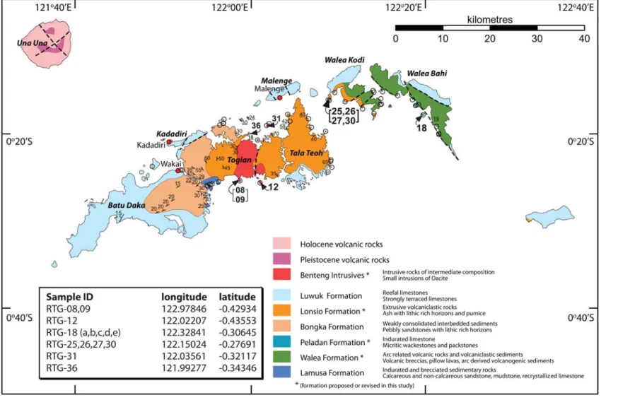
Fig. 3. Simplified geological map of the Togian Archipelago, modified from Rusmanaet al.(1982, 1993) based on new field observations. Island names in bold italics; population centres in regular. Open circles and/or underlined dip measurements indicate locations examined in this study. Other structural information from Rusmanaet al.(1982, 1993).
Arrows and bold numbers (all prefixed RTG-) highlight the location of samples explicitly discussed in the text, for which GPS locations (decimal degrees) are listed in the inset table.
M.A.COTTAMETAL.182 at University of Aberdeen on April 28, 2014http://sp.lyellcollection.org/Downloaded from
through to Quaternary deposits (Fig. 2). The most complete section is seen in the eastern islands (Walea Kodi and Walea Bahi; Fig. 3) where base- ment rocks, possibly of Eocene to Oligocene age, are overlain by Middle Miocene, Pliocene and Quaternary strata. The central and western islands expose more restricted sections dominated by Plio- cene volcaniclastics and clastics respectively.
Lamusa formation
Indurated sedimentary rocks of different types occur in several small exposures at the southern end of the channel between the islands of Batu Daka and Togian (Fig. 3). The rocks are weakly bedded and dip to the north. Lithologies include calcareous sandstones, interbedded with non-calcareous sand- stones and dark mudstones, and dark, fine-grained recrystallized limestones. They are heavily brec- ciated and crushed. All lithologies are cut by small extensional faults. No fossils or sedimentary struc- tures were identified. The formation has a min- imum thickness of 3 m, but neither the top, nor the base was seen. Following Rusmana et al.(1993) we assign these rocks to the Mesozoic Lamusa Formation. Their highly indurated and veined char- acter is consistent with the Mesozoic age suggested by Rusmanaet al.(1993) and suggests that they may form part of the basement of the Togian Islands.
Walea formation
Arc-related volcanic and volcaniclastic rocks are observed in exposures along the western coast of Walea Bahi and eastern coast of Walea Kodi.
They include volcanic breccias, pillow lavas and arc-derived volcanogenic sediments. Well-bedded volcanogenic sedimentary rocks are exposed as a large, possibly fallen, block on the west coast of the southern peninsula of Walea Bahi. Medium- grained, feldspar-rich, grey-brown beds are inter- bedded with green and blue-grey units with a fine- grained green matrix on a scale of c. 5 cm. All show internal stratification and possible grading.
Further north, just south of a large coastal embay- ment, a larger outcrop exposes an in-situ section of gently dipping (19 – 298to the east) volcanogenic sediments (Fig. 4a) including interbedded sands and silts, some of which are calcareous. Mostly beds are laterally persistent with normal grading, parallel and cross-lamination and ripple cross bedding. Bedding parallel bioturbation and water escape structures are evident in the more sandy layers. Finer-grained siltstones dominate the upper part of the exposed sequence. The volcanogenic sedimentary rocks are interpreted to have been deposited as turbidites and debrites in a deepwater arc-related setting.
Volcanic rocks occur along the west coast of the southern peninsula of Walea Bahi and in coastal outcrops along the channel between Walea Bahi and Walea Kodi. They include breccias, pillow lavas and more massive and layered lavas of basal- tic to andesitic composition. The rocks have a fine- grained groundmass of feldspar, pyroxene and altered olivine+phenocrysts of plagioclase feldspar+amygdales (up to 1 cm) of zeolite and/
or calcite. Large blocks (10.6 m) of breccia are exposed in the beach along the west coast of the southern peninsula of Walea Bahi. There are large, sub-rounded, clasts of dark grey (c. 10 cm) and green (c. 6 cm) material within a light grey matrix.
The clasts have within them feldspar phenocrysts and amygdales of low-grade epidote-rich alteration products. Further north, pillows are exposed in several outcrops along the channel between Walea Bahi and Walea Kodi, often forming small head- lands. Pillows are grey greenish in colour, weather- ing to grey brown. In most places they are heavily weathered and altered with late-stage alteration along fractures. Where relatively fresh, pillows show spectacular teardrop shapes (around 30 cm across), picked out by dark, glassy chilled rims of between 0.5 and 3 cm and fine-grained interpillow material (Fig. 4b), which provide right way-up criteria. Pillows contain abundant zeolite and/or calcite amygdales up to 1 cm in size; chilled rims contain small (5 mm) amygdales and alter to rusty coloured skins where weathered. More massive, layered lavas are also present; individual flows are marked by craggy tops and brecciated areas.
Rusmana et al. (1982) reported similar pillow lavas, breccias, conglomerates and sandstones from Poh Head (Fig. 1), at the east end of the East Arm, and within the eastern Togian Islands, assign- ing them both to the Miocene Malik Formation.
Simandjuntak (1986) assigned basaltic rocks from Poh Head to the basalt zone of the Balantak Ophio- lite, and suggested a Late Cenomanian to Eocene age based on K – Ar ages. In a later revision, Rusmanaet al.(1993) assigned these rocks to the Cretaceous Mafic Complex, whilst those in the eastern Togian Islands were reassigned to the Mio- Pliocene Lonsio Formation (see below).
Based on new observations we assign the basal- tic lavas and volcanogenic sedimentary rocks of the Togian Islands to the Walea Formation, a new formation named from the type localities on the islands of Walea Bahi and Walea Kodi. Neither the top, nor the base, of the Walea Formation is observed but there is a minimum thickness of 5 m of pillows and 7 m of volcanogenic sediments.
The total thickness of the formation is probably much greater. The exact age of the Walea Formation is unknown, but it is the stratigraphically oldest and structurally lowest unit seen in the eastern islands.
Volcanic arc sedimentary rocks have not been reported from the East Arm ophiolite. Their associ- ation with basaltic lavas is more similar to the oldest rocks known from the North Arm which formed in an intra-oceanic arc between the Middle Eocene and earliest Miocene.
Peladan formation
Hard, indurated limestones occur on (at least two) small islands situated around 250 m off the central west coast of Walea Bahi. Lithologies include micritic wackestones and packstones with
30 cm
20 cm
20 cm ~2 m
a b
c
d
Fig. 4. Field photographs of the Walea Formation and Lonsio Formation. (a) Arc-related (?) volcaniclastic sediments of the Walea Formation. (b) Basaltic pillows of the Walea Formation exposed on the west coast of Walea Bahi. (c) Well-bedded tuffs of the Lonsio Formation. Coarser tuff units (centre of image beneath pen) show rough stratification, dewatering and cross bedding. Finer tuff units (upper and lower sections of photograph) are more massive, have irregular bases and show an increase in joint density towards the upper boundary (lower section of photograph). (d) Syn-sedimentary folding and faulting within the Lonsio Formation.
M. A. COTTAMET AL.
184
at University of Aberdeen on April 28, 2014 http://sp.lyellcollection.org/
Downloaded from
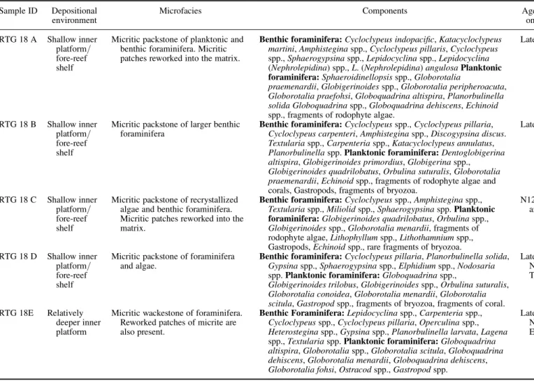
planktonic and benthic foraminifera and fine- grained volcanogenic material (Table 1). These out- crops define the type section for the new Peladan Formation. Benthic and planktonic foraminifera indicate shallow inner platform or fore-reef shelf and deeper inner platform environments (Table 1).
The sequence is well-bedded on a decimetre scale, up to a maximum of around 1 m (modec. 30 cm) and dips gently towards the north. The sequence has a minimum observed stratigraphic thickness of around 12 m. The top and base of the sequence is not seen and the true thickness may be much greater. No other structure (folding/faulting) was observed. In places the beds have a rubbly texture interpreted to reflect re-working of components prior to deposition. Some thin (c. 10 cm), finer grained horizons appear not to have been reworked.
In places the limestone are partially dolomitized.
Early – Middle Miocene limestones of a similar age and character are reported from the North and East Arms of Sulawesi (e.g. Sukamto 1973; Norvick
& Pile 1976; Rusmanaet al.1982; Garrardet al.
1988; van Leeuwen & Muhardjo 2005). In the Togian Islands Rusmana et al.(1982) previously assigned these rocks to the Salodik Formation and suggested a Late Paleocene to Early Miocene age.
Later, Rusmana et al.(1993) reassigned them to the Lonsio Formation tuffaceous units.
Micropalaeontological analyses of larger fora- minifera and planktonic foraminifera were per- formed on five samples of the Peladan Formation (Table 1). Nannofossil dating was not attempted.
We correlate the standard Planktonic Foraminiferal biozones (PZ) with the ‘Letter Stages’ (LS) of the Far East (as defined by BouDagher-Fadel 2008), relative to the geological timescale of Gradstein et al. (2004). Analyses indicate a late Middle Miocene age (PZ: Late N12 – Early N17; LS of the Far East: Late Tf2 – Early Tg). Based on their lithology and age we assign these rocks to the new Peladan Formation, named for one of the two islands on which they were observed.
Bongka formation (Celebes Molasse)
Weakly to moderately consolidated interbedded sediments with characteristic lithic-rich horizons occur in heavily weathered outcrops along the chan- nel between the islands of Batu Daka and Togian.
They are sub-rounded, green-brown, medium- grained sandstones with bands of coarser, angular lithic fragments, medium-grained sandstones with a slabby, bedded character, and brecciated material with possible ultrabasic content. Petrographical analyses reveal a matrix of serpentinite-rich mate- rial. The sequence dips moderately (c. 308) to the north. Sediments with a coarser grain size, but of comparable composition and structure (moderate
c. 308 dips to the NE/NNE) are seen in a more extensive cliff outcrop on a small island east of the village of Katupat. Lithologies at this location include laminated siltstones and sandstones, and pebble conglomerates containing well-rounded peb- bles (up to 2 cm) dominated by ophiolitic material (basalts, dolerites, gabbros and serpentinite) with some chert and limestones. The silts and sands contain abundant, highly oxidized, plant mate- rial. The formation has a minimum thickness, as observed in outcrop, of 15 m but neither the top nor the base of the unit is seen.
Similar deposits, but coarser still in grain size, were observed in roadside outcrops on the northern coast of the East Arm of Sulawesi, west of the town of Bunta (Rusmanaet al.1982, 1993; this study).
Here they comprise coarse, massive, sandstones with pebble-rich horizons that include large clasts (up to 3 cm) of red chert and cobbles (up to 15 cm) of basalts, dolerites, gabbros, metagabbros and serpentinite with some limestones. Again, the sequence dips north at moderate angles of c. 308.
We observed a minimum stratigraphic thickness of around 20 m, although neither the top nor the base of the unit was seen. Based on strong lithological and compositional similarities between these rocks and those within the Togian Islands, we follow Rusmana et al. (1993) in assigning all of these rocks to the Bongka Formation of the Celebes Molasse. In northern Sulawesi palaeontological dating of the Celebes Molasse suggests a Late Early Pliocene to Mid Pleistocene age (Norvick &
Pile 1976; Ratman 1976; Hadiwijoyoet al.1993;
Chamberlain & Seago 1995). Late Miocene – Pliocene ages have been reported for the East Arm (Surono & Sukarna 1996).
The Celebes Molasse has been interpreted as alluvial fan and coastal fan delta deposits that reflect the deposition of locally sourced sediment in alluvial plain environments with a marginal marine influence (Calvert 2000). In contrast, the ophiolitic material observed in the Togian Islands has no local source, and such material can only have been derived from the East Arm Ophiolite.
Based on the relative grain size and shared structural characteristics (gentle north dip), we suggest that outcrops of the Bongka Formation within the East Arm and the Togian Islands represent proximal (coarser) and distal (finer) alluvial fan deposits respectively, both having been transported north from the interior of the East Arm.
Lonsio formation
Volcaniclastic rocks are extensively exposed in coastal outcrops on the northern peninsula of Tala Teoh, the north coast of Togian and the west coast of Walea Kodi. They are grain-supported rocks
Table 1. Biostratigraphical age, facies and palaeoenvironmental analyses of the Peladan formation Sample ID Depositional
environment
Microfacies Components Age (PZ/LS)* (based
on first appearance) RTG 18 A Shallow inner
platform/
fore-reef shelf
Micritic packstone of planktonic and benthic foraminifera. Micritic patches reworked into the matrix.
Benthic foraminifera:Cycloclypeus indopacific,Katacycloclypeus martini,Amphisteginaspp.,Cycloclypeus pillaris,Cycloclypeus spp.,Sphaerogypsinaspp.,Lepidocyclinaspp.,Lepidocyclina (Nephrolepidina) spp.,L. (Nephrolepidina)angulosaPlanktonic foraminifera:Sphaeroidinellopsisspp.,Globorotalia
praemenardii,Globigerinoidesspp.,Globorotalia peripheroacuta, Globorotalia praefohsi,Globoquadrina altispira,Planorbulinella solida Globoquadrinaspp.,Globoquadrina dehiscens,Echinoid spp., fragments of rodophyte algae.
Late N12/Late Tf2
RTG 18 B Shallow inner platform/
fore-reef shelf
Micritic packstone of larger benthic foraminifera
Benthic foraminifera:Cycloclypeusspp.,Cycloclypeus pillaria, Cycloclypeus carpenteri,Amphisteginaspp.,Discogypsina discus.
Textulariaspp.,Carpenteriaspp.,Katacycloclypeus annulatus, Planorbulinellaspp.Planktonic foraminifera:Dentoglobigerina altispira,Globigerinoides primordius,Globigerinaspp., Globigerinoides quadrilobatus,Orbulina suturalis,Globorotalia praemenardii,Echinoidspp., fragments of rodophyte algae and corals, Gastropods, fragments of bryozoa.
Late N12/Late Tf2
RTG 18 C Shallow inner platform/
fore-reef shelf
Micritic packstone of recrystallized algae and benthic foraminifera.
Micritic patches reworked into the matrix.
Benthic foraminifera:Cycloclypeusspp.,Amphisteginaspp., Textulariaspp.,Miliolidspp.,Sphaerogypsinaspp.Planktonic foraminifera:Globigerinoides quadrilobatus,Orbulinaspp., Globigerinoidesspp.,Globorotalia menardii, fragments of rodophyte algae,Lithophyllumspp.,Lithothamniumspp., Gastropods,Echinoidspp., rare fragments of bryozoa.
N12 and younger/Tf2 and younger
RTG 18 D Shallow inner platform/
fore-reef shelf
Micritic packstone of foraminifera and algae.
Benthic foraminifera:Cycloclypeus pillaria,Planorbulinella solida, Gypsinaspp.,Sphaerogypsinaspp.,Elphidiumspp.,Nodosaria spp.Planktonic foraminifera:Globoquadrinaspp.,
Globigerinoides trilobus,Globigerinoidesspp.,Orbulina suturalis, Globorotalia conoidea,Globorotalia menardii,Globorotalia scitula,Gastropodspp., fragments of bryozoa, fragments of coral.
Late N12 – Early N17/Tf3 – Early Tg
RTG 18E Relatively deeper inner platform
Micritic wackestone of foraminifera.
Reworked patches of micrite are also present.
Benthic Foraminifera:Lepidocyclinaspp.,Carpenteriaspp., Cycloclypeusspp.,Cycloclypeus pillaria,Operculinaspp., Heterosteginaspp.,Gypsinaspp.,Planorbulinella larvata,Lagena spp.,Textulariaspp.Planktonic foraminifera:Globoquadrina altispira,Globorotaliaspp.,Globorotalia scitula,Globoquadrina dehiscens,Globorotalia menardii,Globoquadrina dehiscens, Globorotalia fohsi,Ostracodspp.,Gastropodspp.
Late N12 – Early N13/Late Tf2 – Early Tf3
*We correlate the standard Planktonic Foraminiferal biozones (PZ) with the ‘Letter Stages’ (LS) of the Far East (as defined by BouDagher-Fadel 2008), relative to the biostratigraphical timescale (as defined by Gradsteinet al.2004)
M.A.COTTAMETAL.186 at University of Aberdeen on April 28, 2014http://sp.lyellcollection.org/Downloaded from
with a carbonate (dominantly sparry) matrix. Micro- fossils and algal fragments are also embedded within the matrix; their abundance varies between units (Table 2).
The volcaniclastics are well-bedded, commonly at the decimetre scale, with a maximum bed thick- ness of around 3 m. Two main bed types alternate at a range of scales. Individual beds appear laterally persistent at the outcrop scale. Stratified beds are typically around 10 to 30 cm in thickness and show parallel lamination of fine to coarse sand.
They contain rare horizons of small (up to fine pebbles) angular lithic fragments (Fig. 4c). In places the beds show spectacular dewatering struc- tures, and may be wholly or partly cross-bedded, producing an irregular upper surface. The base of the beds is almost universally planar. Stratified units are overlain by fine-grained cream coloured material, which show little variation in grain size or internal structure (Fig. 4c). Beds range in thick- ness from cm scale to a maximum of 3 m. Their bases are commonly irregular, reflecting the topo- graphy of the stratified layer below, and they display an increase in joint density towards the upper boundary, which is characteristically planar.
In places the finer beds may be very thin, or entirely absent from the sequence. Overall, the sequence dips gently in various directions. Locally, the rocks dip steeply and show intense syn-sedimentary folding and faulting (Fig. 4d), interpreted to reflect soft sediment deformation. The sequence has a minimum stratigraphic thickness of around 20 m, however, the top and base of the sequence is not seen and the true thickness is probably much more.
Comparable volcaniclastic rocks are observed on Poh Head, where they include thick sequences of coarse stratified units (this study). Rusmanaet al.
(1982, 1993) described these rocks as tuffaceous sediments and assigned them to the Lonsio For- mation. Simandjuntak (1986) interpreted similar volcanogenic sediments from the East Arm as megacyclic turbidites, and assigned them to the Lonsuit Turbidites of the Batui Group. We interpret these rocks as tuffaceous sediments that reflect rapid aqueous reworking of primary volcaniclastic mate- rial during deposition in a shallow marine environ- ment soon after eruption. Microfossil observations suggest depths less than 200 m. Stratification reflects crude sorting of coarse ash during settling through the water column; cross-bedding may reflect turbidity currents formed by ash initially held in suspension. Finer-grained ash settled more slowly through the water column, draping topography in the underlying coarse units. Pumice is largely absent and may have been floated off and not pre- served (e.g. Freundt 2003). The repeated sequence of coarse and fine tuff may reflect pulses within a
single eruption or input from several eruptions.
Dewatering structures within coarse units suggest rapid loading by the subsequent fine units. Jointing present near the upper boundary of the finer units may be syn- or post-depositional.
Based on their striking similarity to tuffaceous units observed on Poh Head (Simandjuntak 1986;
A. J. Barber, pers. comm. 2009) we assign these rocks to the Lonsio Formation of Rusmana et al.
(1982, 1993). Micropalaeontological analyses of larger foraminifera and planktonic foraminifera were performed on five tuff samples from the Lonsio Formation (Table 2). Nannofossil dating was not attempted. Foraminiferal assemblages range from N4 and younger (PZ) and Te and younger (LS), and constrain a Late Miocene to Early Pliocene age (PZ: N19; LS: Early Th).
Benteng Intrusives
Intrusive rocks of intermediate composition are exposed in isolated outcrops, along the northern and southern coasts of Togian Island. They occur as small intrusions, often forming topographic highs and small islands. We infer the presence of additional intrusive bodies within the interior of Togian Island based on the presence of isolated steep-sided topographic highs visible from the coast as shown on the map of Ku¨ndig (1956). The rocks have a fine to medium grained light-grey groundmass with phenocrysts of phlogopite mica (up to 7 mm)+feldspar (6 – 7 mm)+hornblende (1 – 3 mm)+mafic xenoliths (up to 2 cm). In places feldspar phenocrysts are concentrated into ‘trails’
up to 20 cm long. Orthogonal sub-horizontal and sub-vertical joints spaced at around 20 to 50 cm, and resulting in a characteristic blocky appearance, suggest intrusion at shallow depths. In places the rocks are cut by east – west trending brittle faults, producing breccia zones around 1 m wide.
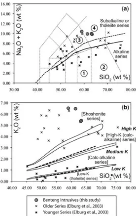
These rocks are classified (Fig. 5; Table 3) as trachydacites and trachyandesites on the total alkalis v. silica (TAS) diagram of Le Maitre (1989) (they are syenites on TAS diagrams adapted for plu- tonic rocks (e.g. Wilson 1989)) and belong to the alkaline magma series (Kuno 1966; Irvine &
Baragar 1971). They have an extremely K-rich chemistry and plot within the shoshonitic field of Rickwood (1989) on a K2O v. SiO2diagram. Intru- sive intermediate rocks were first recognized on Togian Island by Ku¨ndig (1956), who identified rocks of andesitic composition. These were sub- sequently misidentified as basaltic (Rusmanaet al.
1982) or volcaniclastic (Rusmana et al.1993) in character. We assign these intrusive rocks to the new Benteng Intrusives, named for the village of the same name in south central Togian Island (Fig. 3).
Table 2. Biostratigraphical age, facies and palaeoenvironmental analyses of the Lonsio formation
Sample ID Depositional environment Microfacies Components Age (PZ/LS)* (based
on first appearance) RTG 25 Inner neritic, planktonic & shelf
benthic foraminifera drifted/
reworked into volcanic deposits.
Sparitic packstone of volcanic sediments rich in embedded planktonic foraminifera and rare larger benthic and algae fragments
Globoquadrina altispira,Globoquadrinaspp., Orbulinaspp.,Globorotalia margaritae, Globorotalia scitula,Sphaeroidinellopsis subdehiscens,Globigerinoides trilobus, Globigerinoides quadrilobatus,Globorotalia acostaensis, Fragments of rodophyte algae, Elphidiumspp.
N19/Early Th
RTG 26 Inner neritic Sparitic packstone of volcanic sediments with rare embedded planktonic foraminifera
Globigerinoidesspp. N4 and younger/Upper
Te and younger
RTG 27 Sparitic packstone of volcanic
sediments with rare embedded planktonic foraminifera
Globigerinoidesspp. N4 and younger/Upper
Te and younger RTG 30 Inner neritic, planktonic & shelf
benthic foraminifera drifted/
reworked into volcanic deposits.
Sparitic packstone of volcanic sediments rich in embedded planktonic foraminifera and rare larger benthic and algae fragments
Catapsydraxspp.,Orbulina universa, Globoquadrina dehiscens,Pulleniatina primalis,Globoquadrina altispira, Globorotalia globosa,Globorotalia
humerosa,Globorotalia mayeri,Globorotalia scitula,Globigerinoides sacculifer,
Globigerinoides quadrilobatus,Elphidium spp.,Amphisteginaspp.,Heterosteginaspp., Asterigerinaspp.
N19/Early Th
RTG 36 Inner neritic Sparitic packstone of volcanic sediments with rare embedded planktonic foraminifera
Orbulina universa,Globigerinoidesspp., Globigerinoides quadrilobatus, Globoquadrinaspp.
N4-N19/Upper Te – Early Th
*We correlate the standard Planktonic Foraminiferal biozones (PZ) with the ‘Letter Stages’ (LS) of the Far East (as defined by BouDagher-Fadel 2008), relative to the biostratigraphical timescale (as defined by Gradsteinet al.2004)
M.A.COTTAMETAL.188 at University of Aberdeen on April 28, 2014http://sp.lyellcollection.org/Downloaded from
Five high-purity mica separates from four sam- ples of the Benteng Intrusives were dated using
40Ar/39Ar techniques. Samples were crushed, graded using disposable nylon cloth sieves in a brass collar and separated using conventional elec- tromagnetic techniques. High-purity mineral separ- ates were handpicked from the 63 – 250mm fraction, and for RTG-12 from the.250mm fraction, thus any contamination in the analyses is assumed to be due to intra-grain alteration and/or contaminants.
All analyses were undertaken in the Argon Labora- tory of the Research School of Earth Sciences, The Australian National University, using the furnace step-heating technique (Table 4). Samples were irradiated at the McMaster Nuclear Reactor, McMaster University, Canada using Sanidine 92 – 176 from Fish Canyon Tuff, Colorado (K/Ar refer- ence age 28.10+0.04 Ma) as the Fluence Monitor (Spell & McDougall 2003). Ages were calculated using the 40K abundances and decay constants of Steiger & Ja¨ger (1977). Uncertainties in isotopic ratios and ages are quoted at the 1slevel.
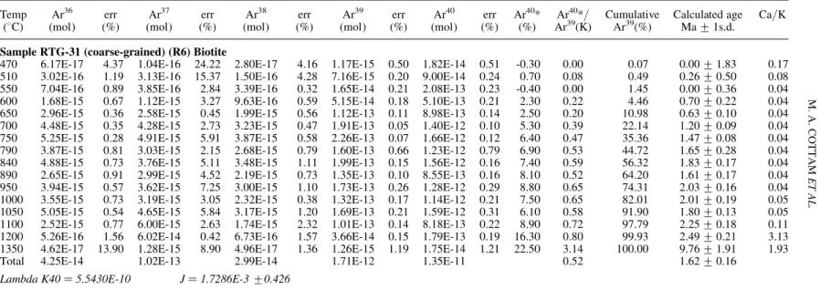
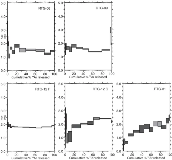
For all samples plots of36Ar/40Ar v.39Ar/40Ar demonstrate the presence of one main gas popu- lation, with varying amounts of contaminants (such as excess argon), and a large atmospheric argon component – particularly in the coarser grained samples (Fig. 6). The oldest ages are preserved in the high-temperature heating steps of coarse- grained (.250mm) biotite from samples RTG12 (2.40+0.01 Ma; MSWD (mean square of weighted deviation) 1.58) and RTG31 (2.02+0.01 Ma;
MSWD 0.01) (Fig. 6). However, significant atmos- pheric argon contents, and evidence of argon loss and possible younger events render the meaning of these ages ambiguous. Analysis of fine-grained (250 – 63mm) biotite from sample RTG12 contains significantly less atmospheric argon than the coarser-grained biotite and produced a reliable, con- sistently flat spectrum of 1.80+0.01 Ma (MSWD 3.95) (Fig. 6). This analysis provides the best age for this sample and the most robust age for the Benteng Intrusives. Analyses of fine-grained mica from two other samples gave robust Pleistocene ages. Despite disturbance during the initial heat- ing steps (linked to variation in Ca), over 50% of the gas emitted from RTG08 produced a strong plateau with an age of 1.52+0.02 Ma (MSWD 0.3) (Fig. 6). Except for several contaminated inter- vening steps, analysis of fine-grained biotite from RTG09 would have produced a similar plateau, giving an age of 1.68+0.09 Ma (MSWD 3.9) with a younger age of 1.37+0.02 Ma evident (Fig. 6).
Based on our new field observations and labora- tory analyses we interpret these rocks as shallow level stocks and dykes of Late Pliocene to Early Pleistocene age. The observed and inferred intrusive Table 3. Major element data (weight %) for samples
of the Benteng Intrusives analysed in this study
Sample ID RTG08 RTG09 RTG12 RTG31
SiO2 63.36 63.14 58.97 61.39
Al2O3 15.52 15.43 15.85 14.54
Fe2O3 3.92 3.77 4.09 5.82
MgO 2.25 2.37 2.97 2.24
CaO 3.67 3.77 4.38 2.21
Na2O 4.41 4.62 3.88 3.44
K2O 5.40 5.34 6.51 6.46
TiO2 0.34 0.33 0.76 0.69
P2O5 0.42 0.41 0.45 0.43
MnO 0.09 0.09 0.06 0.12
Total 99.38 99.26 97.92 97.34
Fig. 5. Major element classification diagrams for the volcanic rock samples analysed in this study. (a) Total alkalis (K2OþNa2O) v. silica (SiO2) diagram. Field boundaries are those of Le Maitre (1989): 1, andesite; 2, dacite; 3, trachyandesite; 4, trachydacite. Subdivision into alkaline and sub-alkaline series: dashed curved line – Irvine & Baragar (1971); solid curved line – Kuno (1966). (b) K2O v. SiO2diagram. Series boundaries and nomenclature: dashed lines and bold italics, Le Maitre (1989); solid lines and nomenclature in parentheses, after Rickwood (1989).
Table 4. 40Ar/39Ar step heating analyses
Temp Ar36 err Ar37 err Ar38 err Ar39 err Ar40 err Ar40* Ar40*/ Cumulative Calculated age Ca/K
(8C) (mol) (%) (mol) (%) (mol) (%) (mol) (%) (mol) (%) (%) Ar39(K) Ar39(%) Ma+1s.d.
Sample RTG-08 (R1) Biotite
600 4.19E-16 0.87 2.04E-15 3.90 1.79E-16 3.38 6.52E-15 0.24 1.30E-13 0.25 4.60 0.92 0.71 2.87+0.78 0.59 650 1.47E-16 1.46 1.89E-15 6.16 1.40E-16 3.73 6.08E-15 0.56 4.77E-14 0.64 8.90 0.70 1.37 2.20+0.36 0.59 700 2.48E-16 0.73 1.96E-15 3.02 2.12E-16 1.75 1.28E-14 0.20 8.16E-14 0.21 10.00 0.64 2.76 2.00+0.14 0.29 750 4.99E-16 0.48 2.07E-15 8.62 3.92E-16 0.29 2.52E-14 0.11 1.57E-13 0.16 5.50 0.34 5.49 1.08+0.16 0.16 800 1.02E-15 0.24 2.88E-15 2.87 7.11E-16 1.25 4.07E-14 0.09 3.24E-13 0.11 6.60 0.53 9.92 1.66+0.09 0.14 840 1.28E-15 0.38 4.70E-15 3.48 8.54E-16 0.21 4.97E-14 0.09 4.00E-13 0.11 5.30 0.43 15.32 1.35+0.13 0.18 890 2.90E-15 0.26 7.08E-15 2.45 1.66E-15 0.91 9.11E-14 0.11 9.10E-13 0.13 5.80 0.58 25.22 1.83+0.12 0.15 930 2.91E-15 0.41 9.44E-15 3.38 2.09E-15 0.54 1.27E-13 0.11 9.24E-13 0.18 6.60 0.48 39.02 1.51+0.14 0.14 970 2.49E-15 0.34 7.38E-15 0.88 2.93E-15 0.63 1.99E-13 0.12 8.37E-13 0.17 11.60 0.49 60.61 1.53+0.06 0.07 1020 1.94E-15 0.48 5.66E-15 3.74 2.42E-15 0.47 1.66E-13 0.09 6.55E-13 0.11 12.10 0.48 78.64 1.50+0.08 0.06 1070 8.81E-16 0.67 6.81E-15 1.57 1.67E-15 0.64 1.21E-13 0.13 3.11E-13 0.20 15.50 0.40 91.83 1.25+0.06 0.11 1140 2.98E-16 0.73 4.17E-14 0.64 9.95E-16 0.72 7.28E-14 0.08 1.19E-13 0.14 28.10 0.46 99.74 1.44+0.06 1.09 1200 5.94E-17 2.41 1.04E-13 1.06 4.91E-17 0.80 2.00E-15 0.50 1.25E-14 0.53 45.10 2.94 99.95 9.20+0.90 103.00 1350 4.00E-17 3.20 1.85E-14 5.07 1.27E-17 20.02 4.88E-16 0.61 1.04E-14 0.70 4.20 0.92 100.00 2.89+4.44 74.20
Total 1.51E-14 2.16E-13 1.43E-14 9.20E-13 4.92E-12 0.49 1.53+0.10
Lambda K40¼5.5430E-10 J¼1.7413E-3+0.413 Sample RTG-09 (R2) Biotite
600 9.22E-16 0.55 2.25E-15 5.24 3.05E-16 0.99 7.96E-15 0.28 2.78E-13 0.31 2.10 0.72 0.32 2.26+0.94 0.54 650 5.83E-16 0.63 1.99E-15 2.74 2.54E-16 0.60 1.06E-14 0.21 1.78E-13 0.26 2.90 0.49 0.75 1.53+0.35 0.36 700 6.71E-16 0.45 3.90E-15 2.72 4.28E-16 0.66 2.20E-14 0.13 2.08E-13 0.16 4.30 0.41 1.65 1.27+0.15 0.34 750 1.09E-15 0.72 4.56E-15 2.40 7.13E-16 1.27 4.12E-14 0.38 3.45E-13 0.43 6.70 0.56 3.32 1.77+0.23 0.21 800 4.73E-15 0.36 1.40E-14 4.79 2.73E-15 0.69 1.52E-13 0.09 1.48E-12 0.11 5.40 0.52 9.50 1.64+0.13 0.17 840 4.03E-15 0.37 1.01E-14 1.43 2.31E-15 0.26 1.28E-13 0.12 1.26E-12 0.13 5.10 0.50 14.70 1.56+0.18 0.15 930 3.69E-15 0.56 1.43E-14 1.65 3.58E-15 0.59 2.38E-13 0.22 1.23E-12 0.34 11.10 0.58 24.37 1.80+0.11 0.11 970 1.92E-15 0.39 1.14E-14 2.18 4.60E-15 0.91 3.39E-13 0.10 7.54E-13 0.19 23.60 0.53 38.13 1.65+0.03 0.06 1020 1.40E-15 0.60 1.07E-14 2.75 4.10E-15 0.33 3.07E-13 0.11 5.74E-13 0.13 26.70 0.50 50.58 1.57+0.03 0.07 1070 2.84E-15 0.40 4.04E-14 1.27 9.22E-15 0.40 7.00E-13 0.06 1.16E-12 0.11 26.40 0.44 78.98 1.37+0.02 0.11 1140 2.07E-15 0.80 2.64E-13 0.22 5.79E-15 0.35 4.27E-13 0.09 8.00E-13 0.12 25.60 0.48 96.31 1.50+0.04 1.17 1200 7.59E-16 1.23 4.84E-13 0.36 9.02E-16 1.33 4.59E-14 0.21 2.19E-13 0.32 19.80 0.95 98.16 2.99+0.20 20.20 1350 4.57E-16 0.84 1.07E-13 0.60 6.62E-16 1.33 4.55E-14 0.09 1.53E-13 0.14 18.40 0.62 100.00 1.95+0.08 4.47
Total 2.52E-14 9.67E-13 3.56E-14 2.46E-12 8.64E-12 0.50 1.57+0.06
Lambda K40¼5.5430E-10 J¼1.7378E-3+0.413
M.A.COTTAMETAL.190 at University of Aberdeen on April 28, 2014http://sp.lyellcollection.org/Downloaded from
700 2.57E-15 0.45 2.14E-15 5.57 6.49E-16 0.88 1.20E-14 0.08 7.64E-13 0.10 0.60 0.40 0.65 1.27+1.05 0.34 750 4.70E-15 0.45 5.49E-15 1.01 1.24E-15 1.91 2.49E-14 0.30 1.41E-12 0.33 1.20 0.68 1.50 2.15+1.08 0.42 800 1.15E-14 0.28 6.25E-15 2.98 2.93E-15 0.83 5.73E-14 0.11 3.43E-12 0.12 1.20 0.70 3.46 2.20+0.58 0.21 840 8.35E-15 0.38 5.59E-15 5.75 2.80E-15 0.28 9.55E-14 0.17 2.50E-12 0.21 1.10 0.30 6.74 0.94+0.36 0.11 900 1.19E-14 0.50 2.25E-15 5.51 5.12E-15 0.45 2.24E-13 0.35 3.61E-12 0.45 2.10 0.34 14.40 1.08+0.38 0.02 980 1.51E-14 0.43 3.31E-15 10.36 9.69E-15 0.98 5.49E-13 0.17 4.79E-12 0.24 6.70 0.58 33.22 1.83+0.13 0.01 1020 6.52E-15 0.29 2.40E-15 11.44 6.72E-15 0.51 4.40E-13 0.08 2.22E-12 0.14 12.80 0.65 48.30 2.04+0.05 0.01 1060 3.49E-15 1.03 2.18E-15 11.95 5.04E-15 0.53 3.52E-13 0.19 1.28E-12 0.23 18.30 0.67 60.37 2.09+0.12 0.01 1100 2.81E-15 0.98 2.34E-15 4.76 5.28E-15 0.76 3.82E-13 0.08 1.14E-12 0.16 25.90 0.77 73.47 2.42+0.07 0.01 1200 2.76E-15 0.43 1.71E-14 0.79 9.57E-15 0.26 7.21E-13 0.06 1.38E-12 0.08 39.70 0.76 98.19 2.40+0.02 0.05 1350 1.94E-16 2.36 2.49E-15 5.92 6.83E-16 1.77 5.27E-14 0.53 9.48E-14 0.64 38.50 0.69 100.00 2.17+0.09 0.09
Total 7.41E-14 5.25E-14 5.06E-14 2.92E-12 2.39E-11 0.65 2.03+0.13
Lambda K40¼5.5430E-10 J¼1.7442E-3+0.426 Sample RTG-12 (fine-grained) (R4) Biotite
600 3.70E-16 1.23 2.29E-15 12.90 1.88E-16 2.11 8.05E-15 0.25 1.18E-13 0.29 7.40 1.09 0.32 3.39+0.51 0.54 650 3.83E-16 0.85 4.55E-15 1.32 2.74E-16 2.01 1.62E-14 0.18 1.23E-13 0.22 7.90 0.60 0.97 1.87+0.19 0.53 700 3.24E-16 1.14 6.82E-15 3.16 4.00E-16 0.98 2.74E-14 0.20 1.14E-13 0.25 15.60 0.65 2.07 2.02+0.13 0.47 750 7.46E-16 1.34 2.17E-14 4.21 1.59E-15 2.31 1.15E-13 0.17 2.92E-13 0.19 24.20 0.62 6.65 1.92+0.10 0.36 800 2.83E-16 0.87 7.56E-15 1.05 9.40E-16 0.45 7.21E-14 0.39 1.26E-13 0.45 32.60 0.57 9.53 1.78+0.04 0.20 850 3.30E-16 1.68 7.82E-15 3.81 1.60E-15 0.54 1.21E-13 0.10 1.72E-13 0.14 41.70 0.59 14.37 1.85+0.04 0.12 890 3.08E-16 1.10 5.27E-15 4.20 2.46E-15 0.78 1.85E-13 0.16 2.03E-13 0.23 52.90 0.58 21.75 1.81+0.02 0.05 930 2.46E-16 0.90 3.26E-15 4.00 3.56E-15 0.29 2.72E-13 0.12 2.37E-13 0.17 66.30 0.58 32.62 1.80+0.01 0.02 970 3.62E-16 1.10 2.77E-15 13.41 4.57E-15 0.44 3.50E-13 0.34 3.17E-13 0.38 63.50 0.58 46.61 1.80+0.01 0.02 1020 5.43E-16 0.74 3.14E-15 0.94 4.57E-15 0.34 3.51E-13 0.08 3.71E-13 0.10 54.20 0.57 60.66 1.79+0.01 0.02 1070 5.92E-16 0.72 6.44E-15 2.47 4.14E-15 0.25 3.15E-13 0.07 3.58E-13 0.10 48.90 0.56 73.27 1.74+0.01 0.04 1140 9.20E-16 0.59 4.58E-14 0.58 6.96E-15 0.18 5.33E-13 0.13 5.91E-13 0.15 52.40 0.58 94.61 1.81+0.01 0.16 1200 2.96E-16 0.73 8.36E-14 0.72 1.71E-15 0.35 1.29E-13 0.09 1.61E-13 0.14 48.90 0.61 99.78 1.90+0.02 1.23 1350 5.45E-17 2.59 6.65E-15 1.25 8.01E-17 4.55 5.50E-15 0.41 1.88E-14 0.44 17.00 0.58 100.00 1.81+0.24 2.30
Total 5.76E-15 2.08E-13 3.30E-14 2.50E-12 3.20E-12 0.58 1.81+0.02
Lambda K40¼5.5430E-10 J¼1.7305E-3+0.356
(Continued)
TOGIANISLANDSANDGORONTALOBAY191 at University of Aberdeen on April 28, 2014http://sp.lyellcollection.org/Downloaded from
Table 4. Continued
Temp Ar36 err Ar37 err Ar38 err Ar39 err Ar40 err Ar40* Ar40*/ Cumulative Calculated age Ca/K
(8C) (mol) (%) (mol) (%) (mol) (%) (mol) (%) (mol) (%) (%) Ar39(K) Ar39(%) Ma+1s.d.
Sample RTG-31 (coarse-grained) (R6) Biotite
470 6.17E-17 4.37 1.04E-16 24.22 2.80E-17 4.16 1.17E-15 0.50 1.82E-14 0.51 -0.30 0.00 0.07 0.00+1.83 0.17 510 3.02E-16 1.19 3.13E-16 15.37 1.50E-16 4.28 7.16E-15 0.20 9.00E-14 0.24 0.70 0.08 0.49 0.26+0.50 0.08 550 7.04E-16 0.89 3.85E-16 2.84 3.39E-16 0.32 1.65E-14 0.21 2.08E-13 0.23 -0.40 0.00 1.45 0.00+0.36 0.04 600 1.68E-15 0.67 1.12E-15 3.27 9.63E-16 0.59 5.15E-14 0.18 5.10E-13 0.21 2.30 0.22 4.46 0.70+0.22 0.04 650 2.96E-15 0.36 2.58E-15 0.45 1.99E-15 0.56 1.12E-13 0.11 8.98E-13 0.14 2.50 0.20 10.98 0.63+0.10 0.04 700 4.48E-15 0.35 4.28E-15 2.73 3.23E-15 0.47 1.91E-13 0.05 1.40E-12 0.10 5.30 0.39 22.14 1.20+0.09 0.04 750 5.25E-15 0.28 4.91E-15 5.91 3.87E-15 0.58 2.26E-13 0.07 1.66E-12 0.12 6.40 0.47 35.36 1.47+0.08 0.04 790 3.87E-15 0.81 3.03E-15 2.15 2.68E-15 0.79 1.60E-13 0.66 1.23E-12 0.79 6.90 0.53 44.72 1.65+0.28 0.04 840 4.88E-15 0.73 3.76E-15 5.11 3.48E-15 1.11 1.99E-13 0.15 1.56E-12 0.16 7.40 0.59 56.32 1.83+0.17 0.04 890 2.65E-15 0.91 2.99E-15 4.52 2.19E-15 0.73 1.35E-13 0.10 8.55E-13 0.16 8.10 0.52 64.20 1.61+0.17 0.04 950 3.94E-15 0.57 3.62E-15 7.25 3.00E-15 1.10 1.73E-13 0.26 1.28E-12 0.29 8.80 0.65 74.31 2.03+0.16 0.04 1000 3.55E-15 0.73 3.19E-15 3.05 2.32E-15 0.38 1.32E-13 0.17 1.14E-12 0.21 7.50 0.65 82.01 2.01+0.19 0.05 1050 5.05E-15 0.54 4.65E-15 5.84 3.17E-15 1.20 1.69E-13 0.21 1.59E-12 0.31 6.10 0.58 91.90 1.80+0.13 0.05 1100 2.52E-15 0.77 6.00E-15 2.63 1.74E-15 2.32 1.01E-13 0.14 8.18E-13 0.22 8.90 0.72 97.79 2.25+0.18 0.11 1200 5.26E-16 1.56 6.02E-14 0.42 6.73E-16 1.57 3.66E-14 0.15 1.79E-13 0.19 16.30 0.80 99.93 2.49+0.21 3.13 1350 4.62E-17 13.90 1.28E-15 8.90 4.96E-17 1.36 1.26E-15 1.19 1.75E-14 1.21 22.50 3.14 100.00 9.76+1.91 1.93
Total 4.25E-14 1.02E-13 2.99E-14 1.71E-12 1.35E-11 0.52 1.62+0.16
Lambda K40¼5.5430E-10 J¼1.7286E-3+0.426
M.A.COTTAMETAL.192 at University of Aberdeen on April 28, 2014http://sp.lyellcollection.org/Downloaded from
bodies follow a broadly north – south trend through the centre of Togian Island, supporting the spatial observations of Ku¨ndig (1956), and indicating a possible structural control on their intrusion.
Luwuk formation
Reefal limestones are found throughout the archipe- lago, and dominate outcrop in the western islands (e.g. Batu Daka). They occur as high cliffs and raised terraces of poorly bedded, rubbly limestones containing broken coral fragments. The limestones have been uplifted to heights of around 200 m within the archipelago and to more than 300 m on the East Arm (Garrard et al. 1988). Following Rusmana et al.(1982) we allocate these rocks a
Quaternary age and assign them to the Luwuk Formation (Garrardet al.1988).
Discussion
The Togian Islands offer a unique opportunity to investigate Gorontalo Bay. Our new stratigraphy offers insight into several aspects of the basin including the nature of its basement rocks, its age and its mode of formation.
Basement rocks beneath Gorontalo Bay Based on geophysical evidence, Silveret al.(1983b) suggested that much of Gorontalo Bay is underlain RTG-08
0 20 40 60 80 100
Cumulative % 39Ar released 0.0
1.0 2.0 3.0 4.0 5.0
RTG-08
0 20 40 60 80 100
Cumulative % 39Ar released 0.0
1.0 2.0 3.0 4.0 5.0
Age (Ma)
RTG-31
0 20 40 60 80 100
Cumulative % 39Ar released 0.0
1.0 2.0 3.0 4.0 5.0
0 20 40 60 80 100
Cumulative % 39Ar released 0.0
1.0 2.0 3.0 4.0 5.0
RTG-09
0 20 40 60 80 100
Cumulative % 39Ar released 0.0
1.0 2.0 3.0 4.0 5.0
RTG-12 C
0 20 40 60 80 100
Cumulative % 39Ar released 0.0
1.0 2.0 3.0 4.0 5.0
Age (Ma)
RTG-12 F
Fig. 6. 40Ar/39Ar age spectra plots for biotite step-heating analyses performed on four samples from the Benteng Intrusives. For sample RTG12 separate analyses were undertaken on coarse (.250mm; RTG-12 C) and fine (63 – 250mm; RTG-12 F) mica.
by basement rocks belonging to the East Sulawesi Ophiolite (East Sulawesi Ophiolite). Beneath these may be continental basement rocks belonging to the leading edge of the Banggai-Sula microconti- nental block (Silver et al. 1983a; Hall & Wilson 2000). Other hypotheses are that the bay is underlain by oceanic crust of the Northern Sulawesi Province (Monnieret al.1995) or that the basement of Goron- talo Bay comprises a complex amalgamation of at least two tectonostratigraphic provinces. The posi- tion of the Togian archipelago in the middle of Gorontalo Bay provides an opportunity to test these hypotheses.
Our new field observations suggest that the central part of Gorontalo Bay, including the Togian Islands, is underlain by oceanic and arc basement of the Northern Sulawesi Province rather than the continental basement of the Banggai- Sula Block. The Walea Formation represents the basement within the Togian Islands. Its age is not known but it is inferred to be older than the Middle Miocene limestones against which it is faulted. The formation comprises an association of volcanic rocks and subordinate volcanogenic sedi- ments that we suggest represent the products of a submerged volcanic arc rather than an ophiolite, as previously interpreted (Ku¨ndig 1956). A similar association of volcanic rocks and subordinate volca- niclastics is reported within the Papayato Volcanic rocks of the North Sulawesi Province (Elburg et al.2003; van Leeuwenet al.2007), and is con- sistent with the suggestion that the basement of this province continues southwards beneath the archipelago. Volcanic rocks (breccias, pillows and lavas) similar to those of the lower parts of the Walea Formation are also reported from the Cre- taceous Balantak Ophiolite of East Sulawesi (Simandjuntak 1986; A. J. Barber, pers. comm.
2009), but they do not show the same association with contemporaneous volcaniclastic sediments.
Geochemical and/or geochronological analyses of the Walea Formation, and comparison with the (Middle Eocene to Early Miocene) Papayato Vol- canic rocks (North Sulawesi Province of Elburg et al.2003) and the (Cretaceous) Balantak Ophiolite (East Sulawesi Ophiolite) would help to resolve this issue but the rocks are so deeply weathered that obtaining suitable material has not so far been possible.
Field investigations and geochemical analyses suggest that the western end of the bay is underlain
by continental crust (Elburg et al. 2003; van Leeuwen & Muhardjo 2005; van Leeuwen et al.
2007) as far east as 1218E (Fig. 1). This material forms the eastern margin of Sundaland and is prob- ably of Australian origin (van Leeuwen & Muhardjo 2005), but was accreted to Sundaland during the mid-Cretaceous (Parkinson 1991; Parkinsonet al.
1998; Hall 2009) and is not part of the Banggai- Sulu block.
Continental crust probably continues north from the Banggai-Sulu microcontinent beneath the Molucca Sea (Silveret al.1983b; Watkinsonet al.
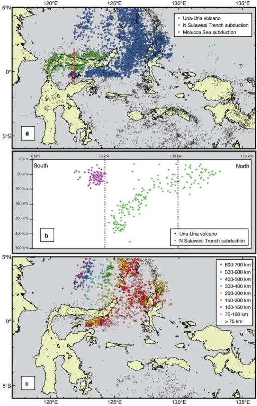
2010). Beneath Gorontalo Bay earthquake hypocen- tres (Engdahlet al.1998) define the southern edge of the westward-subducting Molucca Sea plate. This is a very sharp, almost WNW – ESE, line (Fig. 7a) that we interpret as the former continental – oceanic crust boundary between the Molucca Sea and the Banggai-Sula block. The position of the line implies that continental crust continues north from the Banggai-Sula Islands to the centre of the eastern part of Gorontalo Bay. How far west beneath Gorontalo Bay the continental crust con- tinues is uncertain; the oil that seeps through the ophiolite north of the thrust complex in the East Arm (Ku¨ndig 1956) suggests continental base- ment may extend at least west to about 1228E (Fig. 8).
Miocene carbonate platform
Miocene carbonate rocks are widespread in northern Sulawesi. They include the Middle Miocene lime- stones of the Peladan Formation reported here, car- bonates of the Buol Beds in NW Sulawesi (Ratman 1976; van Leeuwen & Muhardjo 2005), the Salodik Formation within the East Arm (Rusmana et al.
1982), and limestones observed around Palu and the western Toli – Toli region (Sukamto 1973;
Norvick & Pile 1976; van Leeuwen & Muhardjo 2005). Benthic and planktonic foraminifera indicate deposition within inner platform/fore-reef shallow marine environments during the late Early to Middle Miocene (van Leeuwen & Muhardjo 2005;
this study). Jablonskiet al.(2007) report submerged carbonate reefs in Gorontalo Bay based on seismic observations which they interpreted as Oligocene to Middle Miocene in age. The distribution of Miocene carbonate rocks suggests that Gorontalo Bay was an area of extensive carbonate platform deposition during the Miocene. It was probably Fig. 7. Earthquake hypocentres in Eastern Indonesia based on the dataset of Engdahlet al.(1998). (a) Black crosses denote all hypocentres, those assigned to the westward subducting Molucca Sea Plate are highlighted with blue dots, those assigned to subduction at the North Sulawesi Trench are highlighted in green. Hypocentres associated with volcanism at the Una-Una volcano are shown in purple. Red box denotes the line of section illustrated in (b).
(b) North – south cross section though Gorontalo Bay and the Una-Una volcano. Hypocentres associated with volcanism at the Una-Una volcano (purple dots) are notably shallower than those related to the downgoing slab.
M. A. COTTAMET AL.
194
at University of Aberdeen on April 28, 2014 http://sp.lyellcollection.org/
Downloaded from
Fig. 7 (Continued) (c) Earthquake hypocentres assigned to the Molucca Sea Plate coloured based on depth. To aid clarity, hypocentres less than 75 km depth are not shown. Colouration shows that the slab dips gently to the NW but is sharply terminated along its southern edge in a steep upturned lip. Black crosses denote hypocentres at depths greater than 75 km elsewhere in the region. They are almost entirely absent in the Banggai-Sula plate.
characterized by contiguous shallow marine plat- forms, but was certainly not a continuous deep bathymetric feature at this time. In west Sulawesi carbonate deposition terminated by the end of the Middle Miocene (van Leeuwen & Muhardjo 2005).
Rapid Pliocene uplift
The clastic sediments of the Bongka Formation record localized rapid uplift and erosion of the East Arm in the latest Miocene to Pliocene (Surono & Sukarna 1986; Hall & Wilson 2000), instigating the development of the high (in places .3 km) present-day topography. In some cases, the sudden influx of clastic material may have been directly responsible for the reduction of car- bonate areas from large platforms to isolated pin- nacle reefs (Jablonskiet al.2007).
Uplift has previously been attributed to collision between the Banggai-Sula microcontinent and the East Arm (e.g. Garrardet al. 1988; Davies 1990;
Hall 1996; Calvert 2000; Hall & Wilson 2000; van Leeuwen & Muhardjo 2005). This interpretation followed Hamilton’s (1979) proposal of slivers of continental crust moving west from the Bird’s
Head, with westward subduction implied in front of them. However, it has also been suggested that collision between microcontinental blocks and the East Arm began earlier, between the latest Oligocene and Late Miocene (e.g. Audley-Charles 1974; Sukamto & Simandjuntak 1983; Dalyet al.
1991; Parkinson 1991; Smith & Silver 1991;
Bergman et al. 1996; Milsom 2000; Hall 2002;
van Leeuwenet al.2007; Spakman & Hall 2010).
If so, collision significantly predated the rapid uplift and erosion of the East Arm during the latest Miocene to Pliocene, which must have a dif- ferent cause.
Basin subsidence
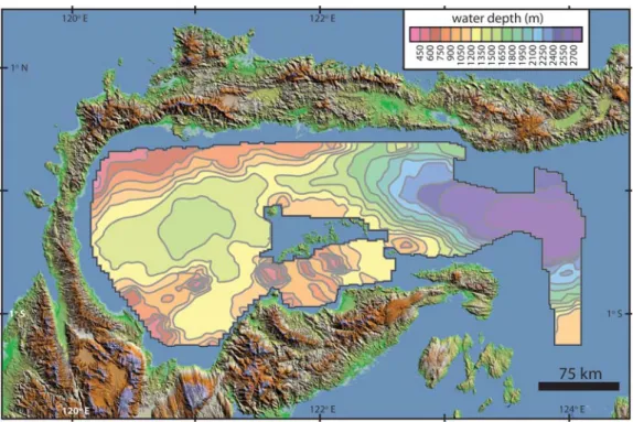
Seismic surveys (Jablonskiet al.2007) and multi- beam surveys of Gorontalo Bay show present-day water depths up to 2000 m in the western part of the basin and.2700 m in the eastern part (Fig. 8).
Sediment thicknesses within these areas may be as great as 10 km (Jablonski et al. 2007). There is a bathymetric high area that links the East Arm and the Togian Archipelago, with water depths of between 500 and 1200 m (Fig. 8), which may continue across the entire bay to the North Arm.
Fig. 8. Detailed bathymetry of Gorontalo Bay, modified from Jablonskiet al.(2007). Topography based on SRTM (Shuttle Radar Topographic Mission) data (courtesy of NASA, NGA & USGS).
M. A. COTTAMET AL.
196
at University of Aberdeen on April 28, 2014 http://sp.lyellcollection.org/
Downloaded from