Virginia, that portion of the James Valley extending west from the Falls to the Mountains, was claimed by several tribes of the Monacan Confederacy. They discovered two of the native towns, Mowhemcho and Massinacak, both situated on the right bank of the James west of the falls and about 14 miles apart. 2 SMITHSONIAN MISCELLANEOUS COLLECTIONS VOLUME 89 The valley of the Rivanna and south to the James is a country of much natural beauty.
Enmye, and that came down to the fall of the leaf and invaded his country. With these continued invasions, the Algonquian villages near the falls would soon be abandoned, allowing the Monacan to advance even further east. The conquest of the region by the northern tribes had probably occurred only a few years before the arrival of the English colonies. - Fox's Neck, mentioned in the judgment of the court, is an arrow trail nearly a mile long and bounded by the left bank of the.
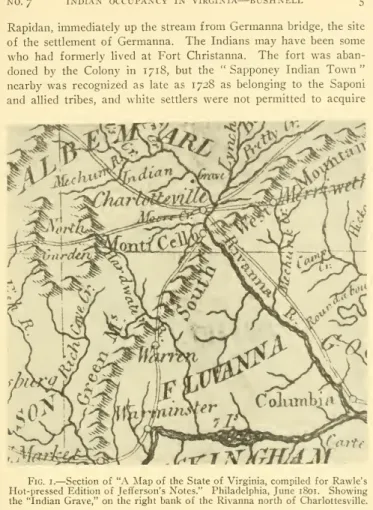
7 INDIAN OCCUPATION IN VIRGINIA BUSHNELL 5 Rapidan, immediately upstream from Germannabridge, the site of the Germanna settlement. Although the hope may have disappeared by the turn of the last century, it was remembered and was clearly indicated on the map of the state of Virginia that accompanied the 1801 edition of Jefferson's Notes. A view looking northwards from the cliffs south of the right bank of the river, over a portion of the village, is shown on plate i.
Fig. 2.-Pipe made of greenish steatite, found in contact with human remains on the site of the old Monasukapanough, on the right bank of the Rivanna, near where the "Indian grave" formerly stood.
NO. 7 INDIAN OCCUPANCY IN VIRGINIA — BUSHNELL 7
EVIDENCE OF AN EARLY PERIOD OF OCCUPANCY As previously stated, it is evident that several distinct groups
8 SMITHSONIAN MISCELLANEOUS COLLECTIONS VOL. 89 an extent that it is difficult to discern signs of the chipping by which
NO. 7 INDIAN OCCUPANCY IN VIRGINIA — BUSHNELL 9
The lack of evidence for the stone's use in recent times suggests that the quarries were opened by the country's earlier inhabitants - those by whom the crude stone tools, now weathered and showing great antiquity, were made and used . The discovery of the tools in the vicinity of ancient quarries tends to strengthen the belief, as previously expressed, that the Virginia specimens were manufactured by the tribe or tribes who occupied the Piedmont and opened the soapstone quarries there long before the Siouan groups from their former habitat came behind the mountains.
SITES, AND THE DISTRIBUTION OF VARIOUS OBJECTS Traces of Indian occupancy are plentiful throughout the region,
Many examples in the United States National Museum were found in or near an old soapstone quarry not far from Portland, Middlesex County, Conn., and are believed to have been implements used in the working of the steatite. And although many interesting localities have yet to be discovered, it is certain that others of equal importance have been destroyed by natural causes. In a country of this character living camps and villages usually stood on or near the banks of streams, very often on the bordering low grounds, which were often inundated.
Two centuries and more have now passed since great camps stood on the banks of the Rivanna, and during the intervening years the stream has often flooded the adjacent regions. It is known that several freshets of unusual volume during the past century have caused radical changes in the appearance of the surface of the regions thus inundated; canyons were formed, some parts of the surface were completely washed away, and other sections were recovered with sand and soil brought down by the currents. Traces of such sites, preserved under these conditions, have been encountered on the banks of the Rivanna both above and below the ancient site, which is believed to have been last occupied by the Saponi - village.
The ditch extended from the left bank of the river to the foot of the rising ground, a distance of about 100 yards.
12 SMITHSONIAN MISCELLANEOUS COLLECTIONS VOL. 89 been found on the surface near the point where the ditch was dug
THE SOURCES OF HARDWARE RIVER
THE BERKELEY CACHE
7 INDIAN OCCUPATION IN VIRGINIA— BUSHNELL I3 were used so far up, though they could be ascended, some were used so far up, though they could be ascended some distance from the mouth of the river. About 200 feet south of the Berkeley residence, near the public road, is a slight depression in which a spring is said to have once flowed.
14 SMITHSONIAN MISCELLANEOUS COLLECTIONS VOL. 89 of a number of white quartz arrowheads found deposited in a fissure
HUNTING GROUNDS AND CAMP SITES BETWEEN THE JUNC- TION OF THE BRANCHES OF HARDWARE RIVER
AND THE MOUNTAINS
7 INDIAN OCCUPATION IN VIRGINIA BUSHNELL I5 quite large, spread over the ground, prove that much work has been done here, and large numbers of arrow-heads and other small chipped objects have been discovered during the past few years. Although the vast majority are made of quartz and quartzite, which can be easily obtained in the neighborhood, other small objects are of jasper, chert and. The latter class of specimens appears to be more abundant on the southern slope and on the adjacent low ground than on the summit plateau.
Traces of several small encampments have been found on the slope, from which small fragments of earthenware vessels and some very crude stone tools have been recovered. As Strachey wrote (p. In the time of their hunting they leave their habitations and gather in companies, like the Tartars, and go with their families to the most deserted places. Hardware River, like this one about two miles below the crossing of the rivers seems to be three branches, is.
Arrowheads have been found in such abundance scattered over the surface of the whole country that they are seldom accorded the interest they deserve, and are often considered too abundant, too common, to occupy a prominent position in the collection. But in time, so much importance will probably be attached to them as a factor in determining the movements of the tribes. They also usually drive them into a narrow part of the country, when they find the advantage: and then force them into the river, where they have Ambuscadoestokilltem with their boats."
The uplands of the Oliver farm, with a plateau sloping south, east, and north to the swampy borders of two small streams, would be very suitable for the hunt described and. With Deare putty and the tops of the Deares homes, boiled to a lustre, they produce a luster that will not dissolve in cold water." By these simple means an ordinary point would probably be made in a few minutes, and the material was plentiful. Over 2,500 arrowheads and other small broken objects have been collected during the last three years from an area about half a mile square at the junction of the Hardware branches, including the Oliver farm and adjoining lands.
Hardware River, near the intersection of the old Lynchburg street, showing a primitive suspension foot bridge high above the water. Often a so-called arrowhead will be encountered which will have the edge of the base and the edges of both notches quite smooth and polished, while the two edges that continue from the shoulders to the tip will be rough and sharp as if recently chipped . It may have been a knife mounted in such a way that the edge of the base became worn and smooth, while it was necessary from time to time to resharpen or rather to cut the cutting edges.
Evidence of a small camp was disclosed on a hillside a hundred yards or more from the left bank of the South Branch of the Hardware, about midway between the junction of the branches and the Red Hill School. Besides the numerous arrow-heads and other small chipped objects found in the vicinity, there were several axes, two of which are shown in Plate 9, aande.
INDIAN OCCUPANCY IN VIRGINIA BUSHNELL 19 inches below the surface in a garden, but whether it had been inten-
In the latter, a new perforation was initiated but not completed, and the edges of the broken tip were not smoothed. To the southwest of the Oliver residence, near the foot of the slope, a short distance from the left bank of the South Branch, are traces of either a more extensive camp, or, more likely, a town that was frequently inhabited. The spring once issued from the hillside just above the town, and the water flowed through a narrow channel to join a branch a few^ hundred yards away.
About one-third of a mile west of the Oliver house, on both sides of a small stream which runs into the middle branch just before the latter joins the north fork of the hardware, are traces of a camp.
NO. 7 INDIAN OCCUPANCY IN VIRGINIA — BUSH NELL 21
SUTHERLAND SITE
BURRUSS SITE
22 SMITHSONIAN MISCELLANEOUS COLLECTIONS VOL. 89 Crossroads, and about i mile west of south from the Red Hill
COOK SITE
6. Mortar made from a block of amphibolite, found at Browns Cove, near the foot of the Blue Ridge, Albemarle County. The remote, protected sites along the foot of the mountains were often occupied by small groups, probably hunters, whose camps are regularly revealed.


