Holocene Vertebrate Fossils from Isla Floreana, Galapagos
DAVID W. STEADMAN
SMITHSONIAN CONTRIBUTIONS TO ZOOLOGY • NUMBER 413
Emphasis upon publication as a means of "diffusing knowledge" was expressed by the first Secretary of the Smithsonian. In his formal plan for the Institution, Joseph Henry outlined a program that included the following statement: "It is proposed to publish a series of reports, giving an account of the new discoveries in science, and of the changes made from year to year in all branches of knowledge." This theme of basic research has been adhered to through the years by thousands of titles issued in series publications under the Smithsonian imprint, commencing with Smithsonian Contributions to Knowledge in 1848 and continuing with the following active series:
Smithsonian Contributions to Anthropology Smithsonian Contributions to Astrophysics
Smithsonian Contributions to Botany Smithsonian Contributions to the Earth Sciences Smithsonian Contributions to the Marine Sciences
Smithsonian Contributions to Paleobiology Smithsonian Contributions to Zoology
Smithsonian Folklife Studies Smithsonian Studies in Air and Space Smithsonian Studies in History and Technology
In these series, the Institution publishes small papers and full-scale monographs that report the research and collections of its various museums and bureaux or of professional colleagues in the world of science and scholarship. The publications are distributed by mailing lists to libraries, universities, and similar institutions throughout the world.
Papers or monographs submitted for series publication are received by the Smithsonian Institution Press, subject to its own review for format and style, only through departments of the various Smithsonian museums or bureaux, where the manuscripts are given substantive review.
Press requirements for manuscript and art preparation are outlined on the inside back cover.
Robert McC. Adams Secretary
Smithsonian Institution
Holocene Vertebrate Fossils from Isla Floreana, Galapagos
David W. Steadman
SMITHSONIAN INSTITUTION PRESS City of Washington
1986
Steadman, David W. Holocene Vertebrate Fossils from Isla Floreana, Galapagos. Smith- sonian Contributions to Zoology, number 413, 103 pages, 25 figures, 4 plates, 12 tables,
1986.—This study surveys the late Holocene vertebrate fossil record from Isla Floreana, Galapagos. Over 20,000 fossils from four lava tubes in the arid lowlands near Post Office Bay are associated with six radiocarbon dates of 2400 years B.P. or younger. The fossils, most of which originated as regurgitated pellets of barn owls, represent more than 1100 individual animals of 24 indigenous species. They include six species now extinct on Floreana: Geochelone elephantopus (tortoise), Alsophis biserialis (snake), Tyto punctatissima (Galapagos Barn Owl), Mimus trifasciatus (Floreana Mockingbird), Geospiza nebulosa (Sharp-beaked Ground Finch), and Geospiza magnirostris (Large Ground Finch). These species are, respectively, 1 st, 7th, 16th, 6th, 15th, and 2nd in abundance among all species recorded as fossils, making up 57% of the individuals in the fossil fauna. In addition, the 3rd and 4th most common fossil taxa, Tropidurus grayii (lava lizard) and Zenaida galapa-
f
oensis (Galapagos Dove), are extremely rare today on Floreana. Thus, extinction probably ias changed the composition of Floreana's fauna even more than is suggested by the number of extinct species alone.While the e\idence is circumstantial, I believe that all extinction on Floreana is related to human impact, directly through predation and habitat alteration, and indirectly through the effects or alien animals (rats, mice, cats, dogs, pigs, goats, cattle, and donkeys). People and feral mammals have lived on Floreana since 1832, and most or all vertebrate extinction occurred within the succeeding 40-50 years. Direct predation by man and introduced mammals was probably the main cause of extinction only for Geochelone elephantopus, although such predation may have been involved to some extent in each of the other extinctions. Loss of preferred prey species and human predation probably caused the extinction of Tyto punctatissima. Extinction of Mimus trifasciatus and Geospiza magnirostris may have resuftea from destruction of Opuntia cactus by feral herbivores. Extinction of Geospiza nebulosa may be related to habitat changes in the highlands. Buteo galapagoensis (Galapagos Hawk), though not recorded as a fossil, is also apparently extinct on Floreana, with direct human predation likely to be the main cause. All extinction on Floreana occurred in historic times; whether this is true elsewhere in the Galapagos awaits more research.
Lasiurus borealis (Red Bat) is the only indigenous mammal recorded as a fossil. The absence of fossils of cricetine rodents or Conolophus spp. (Land Iguana) is evidence that these forms never occurred on Floreana. The lack of fossils of Coccyzus melacoryphus (Dark-billed Cuckoo) and Dendroica petechia (Yellow Warbler), which occur commonly on Floreana today, is evidence that these two species colonized the Galapagos very recently.
Fossil records depend upon suitable environments of deposition. The Galapagos Islands, being of recent volcanic origin, lack many potentially fossiliferous geological features such as fine-grained alluvial sediments, indurated sand dunes, or limestone caves and sinkholes.
Fortunately, lava tubes, which are very well suited for accumulation and preservation of vertebrate fossils, are common on certain islands in the Galapagos.
Fossils enable us to reconstruct undisturbed (pre-human) insular faunas more com- pletely than previously possible. Modern biogeographical studies usually do not consider now natural the faunas are; they would benefit by considering changes wrought by human impact. The field of island biogeography woula profit from a renewed emphasis on the collection of original field data rather than the current trend of theoretical studies that often are based upon inadequate or poorly understood data.
OFFICIAL PUBLICATION DATE is handstamped in a limited number of initial copies and is recorded in the Institution's annual report, Smithsonian Year. SERIES COVER DESIGN: The coral Montastrea cavernosa (Linnaeus).
Library of Congress Cataloging in Publication Data Steadman, David W.
Holocene vertebrate fossils from Isla Floreana, Galapagos.
(Smithsonian contributions to zoology ; no. 413) Bibliography: p.
Supt. of Docs, no.: SI 1.27:413
1. Vertebrates, Fossil. 2. Paleontology—Recent. 3. Paleontology—Galapagos Islands—
Santa Maria Island. I. Title. II. Series.
QL1.S54 no. 413 [QE881] 591 s [566] 85-600002
Page
Introduction 1 Abbreviations 1 Acknowledgments 2 Materials and Methods 3 Field Work 3 Museum Research 4 Modern Specimens Examined 5 Place Names 5 Background Studies 6 Geology 6 Climate 10 Paleoclimate 12 Vegetation 13 The Fossil Sites 15 The Caves 15 Stratigraphy 20 Chronology 25 The Fossil Fauna 27 Systematic Paleontology 37 Discussion 60 Human History 60 Introduced Mammals 61 Extinction 63 Theoretical Biogeography and Fossils 76 Animals Not Recorded As Fossils 83 The Paleontological Potential of the Galapagos 85 Summary and Conclusions 86 Literature Cited 89 Plates 100
in
Holocene Vertebrate Fossils from Isla Floreana, Galapagos.
David W. Steadman
Introduction
Biologists have long held the Galapagos Islands in high esteem. Even non-biologists are im- pressed by the living things they see there, espe- cially by the tameness of the native animals.
Situated in the equatorial Pacific Ocean, the Galapagos Islands possess a terrestrial flora and fauna that is derived almost entirely from the South American mainland, nearly 1000 km to the east. More than any other locality in the world, these inhospitable volcanic islands have been regarded as a Mecca to which many natural historians sooner or later pay homage. Evolution- ary biologists, biogeographers, and ecologists have found the Galapagos particularly enticing as an unparalleled "natural laboratory." In at- tempting to reconstruct the evolution of the ver- tebrates that inhabit the Galapagos, biologists have lacked any paleontological evidence. Dur- ing five trips to the Galapagos since 1978,1 have collected fossils of reptiles, birds, and mammals from lava tubes on five of the larger islands in the group—Santa Cruz, San Cristobal, Floreana, Rabida and Isabela. These specimens represent the first serious paleontological effort to docu- ment the evolution, past distribution, and extinc- tion of vertebrates in the Galapagos.
This paper will report comprehensively on the fossils of Floreana, an island with a colorful hu- man history and a tragic biological history. My
David IV. Steadman, Biological Survey, New York State Museum, The State Education Department, Albany, New York 12230.
studies of the fossils from the other four islands are still incomplete. The fossils described herein, none of which predates with certainty even the Holocene, provide critical new evidence for un- derstanding the extinction and biogeography of the vertebrates of Floreana and the entire Gala- pagos Archipelago.
ABBREVIATIONS.—Terminology used through- out this work includes the following:
B.P. before present (= before A.D. 1950)
CDRS Charles Darwin Research Station, Santa Cruz, Galapagos
ITCZ Intertropical convergence zone MNI minimum number of individuals
The following persons, listed in Table 1, as- sisted in field work on Floreana:
MJCGD DG HH JRH
GM MP DWS ENS
Maria Jose Campos Gayle Davis David Graham Harvey Helman James R. Hill, III
Godfrey Merlen Miguel Pozo David W. Steadman Edward N. Steadman
For species accounts in the "Systemic Paleon- tology" section, the following acronyms are used for the four fossil caves. Many fossils were cata- logued as lots, so a single catalogue number may represent many fossils.
CPOI Cueva de Post Office (Inferior) CPOS Cueva de Post Office (Superior) FC Finch Cave
BOC Barn Owl Cave
I examined modern specimens of reptiles, birds, and mammals from the collections that follow. These specimens, listed below, are skele- tons (or, for some mammals, skin and skulls) unless stated otherwise.
BM(NH) British Museum (Natural History) CAS California Academy of Sciences
NMNH National Museum of Natural History, Smith- sonian Institution
RIB Robert I. Bowman Collection, San Francisco State University
UCMVZ Museum of Vertebrate Zoology, University of California, Berkeley
USNM former United States National Museum, collec- tions in the National Museum of Natural History, Smithsonian Institution
ACKNOWLEDGMENTS.—My field work in the Galapagos has been funded by Fluid Research Grants from the Smithsonian Institution through S. Dillon Ripley and Storrs L. Olson, with sup- plementary funds from the Graduate Student Development Fund, University of Arizona. For permits and other logistic aid, I thank the staffs of Parque Nacional Galapagos, particularly Mi- guel Cifuentes and Fausto Cepeda, and the Charles Darwin Research Station, especially Don Luis Ramos. For dedicated field assistance in the Galapagos, I am indebted to Maria Jose Campos, Gayle Davis, James R. Hill, III, Godfrey Merlen, Miguel Pozo, Edward N. Steadman, and Lee M.
Steadman. Shorter periods of help were kindly provided by Jacinto Gordillo, David Graham, Harvey Helman, Paul S. Martin, Mary Kay O'Rourke, and Arnaldo Tupiza. The De Roys (Andre, Jacqueline, and Gil), the Devine's (Bud, Doris, and Steve), and the Moore's (Alan and Tui De Roy) provided all sorts of advice and assistance during field work. Marsha S. Cox, Minard L. Hall, and Tom Simkin have been very helpful in many aspects of my work.
I appreciate the services rendered by the Di- vision of Amphibians and Reptiles, the Division of Mammals, and the Division of Vertebrate Pa- leontology at NMNH. For help and companion- ship that is too extensive to detail, I am very grateful to the people of the Division of Birds, NMNH, and the Laboratory of Paleoenviron-
mental Studies, Department of Geosciences, Uni- versity of Arizona. Museum research was funded by a Summer Visiting Student Fellowship, a Pre- doctoral Fellowship, and two Scholarly Studies Grants at the Smithsonian Institution, a National Science Foundation Grant (DEB-7923840) to Paul S. Martin, and a National Geographic So- ciety Grant. I thank the following persons who allowed me to examine specimens: Ian C.J. Gal- braith (BM(NH)), Luis F. Baptista, Barry Roth, and Jacqueline Schonewald (CAS), Robert I.
Bowman (RIB), Ned K. Johnson, Victoria M.
Dziadosz, and Anne D. Jacobberger (UCMVZ), J. Phillip Angle, Michael D. Carleton, Ronald I.
Crombie, Linda K. Gordon, Jeremy J. Jacobs, and Storrs L. Olson (NMNH).
Peter Ballmann kindly translated pertinent portions of Abs et al. (1965) and Steindachner (1876). John E. Cadle, Ronald I. Crombie, and Charles R. Crumly provided assistance with her- petological references. Ellen M. Paige rendered Figures 2, 4, 6, 9, 11, 13, and 15-20. Figure 1 is by Lawrence B. Isham. Victor E. Krantz pho- tographed these figures, as well as the plates. He also printed all other figures. Figures 3, 7, 22, and 23 are based upon photographs by James R.
Hill, III, while Figures 8, 10, and 12 were pho- tographed by Edward N. Steadman. I took the photographs for Figures 5, 14, 24, and 25. Rob- ert J. and Jennifer Emry, Storrs L. Olson and Helen F. James, Jean A. Sammon, and Norman E. and Theresa I. Steadman provided badly needed housing during times of maximal anxiety.
My knowledge of insular biology has been en- riched by many people, but especially Ronald I.
Crombie, Uno Eliasson, Peter R. and B. Rose- mary Grant, Helen F. James, Paul S. Martin, Ernst Mayr, Godfrey Merlen, Storrs L. Olson, Gregory K. Pregill, Clayton E. Ray, Robert P.
Reynolds, and Frank J. Sulloway. I particularly appreciate the help of Gayle Davis with the hu- man history, and of Bruce D. Barnett for his information on introduced animals. Steven M.
Chambers and Scott E. Miller graciously volun- teered to identify the land snails and insects, respectively, from the fossil sites. Miller's coor-
dination of the insect identifications was done with assistance and information from L. Burham, T.L. Erwin, R.C. Froeschner, L. Masner, A.F.
Newton, L.M. Roth, R.R. Snelling, D.R. White- head, and N.E. Woodley.
This paper represents a revision of my doctoral dissertation in the Department of Geosciences, University of Arizona. Debbie Gaines and Jim I.
Mead kindly provided much assistance in dealing with the academic bureaucracy. I thank the mem- bers of my graduate committee, Paul S. Martin, Owen Davis, C. Vance Haynes, Storrs L. Olson, and Stephen M. Russell, for their helpful criti- cisms of my dissertation. Charles R. Crumly and Peter R. Grant commented on an earlier draft of this manuscript. The final draft was read by W. Ronald Heyer, Paul S. Martin, Storrs L.
Olson, and Gregory K. Pregill. This is contribu- tion number 370 of the Charles Darwin Foun- dation for the Galapagos.
Finally, I would like to thank Marsha S. Cox, Paul S. Martin, Storrs L. Olson, and S. Dillon Ripley for their undying interest in, and support for, my paleontological research in the Galapa- gos.
Materials and Methods
Throughout this paper, I will refer to the bones collected in the caves as "fossils." I prefer not to use the term "subfossil," which is often associated with non-mineralized Holocene bones, because many of the specimens from Floreana are well mineralized and were collected from within sediments. The fossils from Floreana vary in preservation, however, from that of nearly fresh bone to complete mineralization. It is sim- pler to refer to all of them as fossils than to attempt to distinguish unmineralized from mineralized bones by using the awkward term
"subfossil."
FIELD WORK.—I visited Floreana 5 times (25 June-9 July 1978, 22 October-1 November 1980, 26 December 1980, 10 April 1982, 24, 25 May 1983). All fossil collections were made dur- ing the first two trips (Table 1). I also visited the
satellite islands of Champion (4 July 1978, 26 October 1980, 24 May 1983) and Caldwell (26 December 1980) to observe living plants and animals. On Floreana, I spent at least 2-3 hours per day outside of the caves, observing plants and wildlife, especially the birds.
We (names listed in Table 1) visited the Bahia de las Cuevas region from 22-26 October 1980.
The caves of this area, described in Montoriol- Pous and Escola (1975), are not lava tubes but are weathering features in the sides of scoria cones. The sediments in these shallow caves were essentially unfossiliferous, and seemed to be of very little antiquity. Fossils of boney fish, tor- toises (Geochelone elephantopus), and Dark- rumped Petrels (Pterodroma phaeopygta) were col- lected in small numbers from these caves, but the only organic material commonly found here was the trampled dung of feral goats. The limited faunal remains from these caves will not be dis- cussed further.
With the maps of Montoriol-Pous and Escola (1975), we searched for the caves they reported, Cueva de Post Office (Inferior and Superior), on 25-27 June 1978. Upon finding these lava tubes, we collected fossils for the next 10 days. On 7-9 July 1978, we searched for new caves and com- pleted the screening, sorting, and packaging of fossils and sediment. We discovered Finch Cave at this time, but collected no fossils there. We visited the Post Office Bay region again from 26 October to 1 November 1980, collecting fossils in Cueva de Post Office (Inferior and Superior), Finch Cave, and the newly discovered Barn Owl Cave. In each instance, the basic procedure was as follows:
1. Search for and locate lava tubes.
2. If fossiliferous, make maps of the location of the lava tube and the plan of the floor.
3. Collect bones and other organic material on the surface.
4. Look for areas of sediment accumulation and excavate a test pit, saving sediment sam- ples from all designated levels.
5. Describe the stratigraphy of a wall of the test pit.
TABLE 1.—Fossil localities on Floreana (abbreviations of collectors' names explained in "Introduction").
Locality Cueva de Post Office (Inferior)
Edge of inundated zone Room 1
Room 2 Room 3 Room 4 Excavations 1, 2 Excavation 3 Cueva de Post Office (Superior)
Area 1 Area 2 Area 3 Excavations 1, 2 Excavations 3, 4 Finch Cave
All areas Barn Owl Cave
Rooms 1-3 Excavation 1
Collectors
DWS, DG
DWS, DG, HH, MP DWS, MJC.JRH, ENS DWS, MP
DWS, MJCJRH, ENS DWS, HH, MP DWS, MJCJRH, ENS DWS, HH
DWS, MP DWS, MP
DWS, MP
DWS, MJCJRH, ENS DWS, MP
DWS, MJCJRH, ENS DWS, MP
DWS, DG, HH, MP DWS, MJCJRH, ENS DWS, MJCJRH, ENS DWS, MJCJRH, ENS DWS, MJCJRH, ENS
Date of collection
2Jul 1978 27Jun 1978 27Oct 1980 27Jun 1978 26Oct 1980 30Jun 1978 27Oct 1980 30Jun 1978 4Jul 1978 6Jul 1978
28Jun 1978 28Oct 1980 28, 30Jun 1978 28Oct 1980 31 Jun 1978 ljul 1978 28Oct 1980 29Oct 1980 30,31 Oct 1980 31 Oct 1980
6. Screen the sediment from the test pit at a convenient location outside of the lava tube.
7. If the sediment is highly fossiliferous, then enlarge the excavation laterally, following any discernible stratigraphic units.
8. Double-check the original description of the stratigraphic section, taking additional sedi- ment samples if necessary.
9. Line the excavation with a plastic sheet and fill it in with rubble.
10. Screen all remaining excavated sediment at a point outside the cave.
11. Package fossils and sediment samples.
12. Transport by boat all collected materials to CDRS for further sorting and packaging, in
preparation for shipment to NMNH.
We used two sizes of screens, XA inch mesh and '/i6 inch mesh (window screen). All maps were made by doing a traverse with a Brunton pocket transit and a 20 m line. The vegetation made a longer line impractical outside of the caves.
Within the caves, the width of the floor was measured by holding a 25 m steel tape at right angles to 1 m intervals on the directionally ori- ented 20 m line. These measurements were rounded to the nearest 0.1 m or 0.5 m, depend- ing on limitations of time.
MUSEUM RESEARCH.—At NMNH I unpacked and cleaned the fossils, which then I sorted into broad taxonomic categories. Precise identifica-
tions were made by comparisons with modern skeletons, often aided by a binocular dissecting microscope. Measurements were made with dial calipers of 0.05 mm increments, rounded to the nearest 0.1 mm. The approximately 20,000 fossil specimens are catalogued in the collection of the Department of Paleobiology, NMNH. Repre- sentative samples of the fossils have been pre- sented to the museum of CDRS.
MODERN SPECIMENS EXAMINED.—Rep-
tiles: Phyllodactylus galapagensis: USNM 223988, 223989. Tropidurus bivittatus: USNM 223987. Alsophis barringtonensis: USNM 223986.
Birds: Pterodroma phaeopygia: USNM 502214, 547924. Puffinus Iherminieri: USNM 488422, 498002. Oceanites gracilis: USNM 491398. Pela- godroma marina: USNM 496759. Fregetta tropica:
USNM 553239. Nesofregetta albigularis: USNM 498012. Halocyptena microsoma: USNM 498395.
Oceanodroma tethys: USNM 321612. Oceano- droma castro: USNM 490825, 491205. O. leuco- rhoa: USNM 498389, 498391. O. tristrami:
USNM 289202. 0. monorhis: USNM 500261. O.
markhami: USNM 497962. O. hornbyi: USNM 491400. 0. homochroa: USNM 500220. O. fur- cata: USNM 556268. 0. melania: USNM 498407. Nyctanassa violacea: USNM 18028,
18501, 318840-318842. Zenaida galapagoensis:
USNM 320829. Tyto punctatissima: UCMVZ 140963. T. alba: USNM 500619. Pyrocephalus nanus: UCMVZ 130127. Myiarchus magnirostris:
UCMVZ 151395. Mimus trifasciatus: BM(NH) 1837.2.21.401 (skin), 1899.9.1.3 (skin), 1899.9.1.4 (skin); RIB 436SLB, 437SLB. M.
macdonaldi: BM(NH) 1899.9.1.6 (skin), 1899.9.1.9 (skin); RIB 1424RIB, 1431 RIB;
UCMVZ 140968, 140971, 140972. M. parvulus:
BM(NH) 1899.9.1.64 (skin), 1899.9.1.68 (skin);
RIB 1507RIB, 1509RIB; UCMVZ 140974- 140978; USNM 19802, 321068, 321069. Af.
melanotis: BM(NH) 1899.9.1.17 (skin). Dendroica petechia: UCMVZ 130131. Geospiza nebulosa:
UCMVZ 93213-93219; USNM 116117. G. fu- liginosa: UCMVZ 93181, 93182, 130277,
130278, 130285, 130286, 130296, 130298, 130299, 141019-141021; USNM 321070,
345594, 345595. G. fortis: UCMVZ 93140, 93141, 93143, 93169-93174, 130137, 130149, 130175, 130178, 130181, 130190, 130191, 130195, 130198, 130204, 130206, 130247- 130249, 141004, 141006; USNM 344819, 345593. G. magnirostris: BM(NH) 1885.12.14.280 (skin), 1899.9.1.171 (skin);
UCMVZ 93084, 130150, 130160, 130164, 130170, 140985 (skin), 140993, 140996; USNM 291411. G. scandens: UCMVZ 93116-93119, 93121-93124; USNM 20734, 345597. G. coni- rostris: UCMVZ 93105. G. crassirostris: UCMVZ 93205, 93207, 93208, 130335. G. parvula:
UCMVZ 93210, 93211, 130429, 130431, 130438, 130454, 130459, 130483, 130490, 130508, 141056; USNM 20533. G. pauper:
UCMVZ 141054. G. psittacula: UCMVZ 130354, 130365, 130367, 130378, 130381, 130383, 130386, 130387, 130393, 130397, 130402, 130413-130415. G. pallida: UCMVZ 93203, 130534, 130544, 130550, 150551, 130553, 130554. G. olivacea: UCMVZ 93220, 93221, 130563, 130569, 130585; USNM 345598.
Mammals: Lasiurus borealis: UCMVZ 65510, 101913, 108974, 119904, 126482, 130987, 136563, 145006, 145016, 152154. L. ega:
UCMVZ 85284, 136048, 140885, 144959, 144960. L. dnereus: CAS 13272; UCMVZ 145371. L. semotus: UCMVZ 114344, 114345.
L. seminolus: UCMVZ 6844. L. floridanus:
UCMVZ 70507, 126103. L. intermedius:
UCMVZ 84219, 104131. Mus musculus: USNM 271417, 361409. Rattus rattus: USNM 664, 503767. Felis catus: USNM 253239, 278658. Sus scrofa: USNM 651.
PLACE NAMES.—Place names in the Galapagos either have both Spanish and English versions, or are a combination of the two languages. Thus the reader must forbear such hybrid combina- tions as "Cueva de Post Office." In this paper, I will attempt to use the name that is used most often today by residents and scientists in the islands, showing no partiality to Spanish or Eng- lish. For the past 20 years, there has been a trend among English-speaking peoples to use an in- creased amount of Spanish for place names in
the Galapagos. I will abide by this trend as much as possible.
Throughout this paper, I will use the name Floreana. Like most major islands in the Gala- pagos, Floreana is blessed with several names, reviewed here in an attempt to minimize confu- sion. "Santa Maria," the official Ecuadorean name for the island, is used only occasionally.
"Charles," in honor of King Charles II of Eng- land, a Stuart king of the late 17th century, was the name used by most English-speaking persons, including buccaneers, explorers, whalers, and sci- entists, until a decade or two ago. The name Charles is derived from the name "King Charles's Island" that was used on the map prepared by William Ambrose Cowley in 1684, and repro- duced in Beebe (1924, fig. 78) and Slevin (1955, map 1; 1959:19). The island named "Santa Maria de l'Aguada" on Cowley's map (this name pre- sumably added after 1684) apparently is also Floreana (Markham, 1880; personal observa- tion). The island designated on Cowley's map as
"King Charles's Island" is less accurate, in both location and shape, than the one named "Santa Maria de l'Aguada." The name "Isle de Saute"
was used for Floreana by Ensign Le Sieur de Villefort of the French frigate Philippeaux in 1700. The name "Mercedes" was used by Gen- eral Jose Villamil during his stay on Floreana in the 1830s and 1840s, according to the account of Captain Henri Louns, Compte de Gueydon, of the French brig-of-war Le Genie (Slevin, 1959:89), although later in the same account Captain Gueydon used the name "Mercedes" for Isla San Cristobal. Floreana is the name used invariably today by residents and most scientists, regardless of their native tongue. Occasionally Floreana is spelled "Floriana," especially in works of the 19th century. The name Floreana is at- tributed to General Villamil, in honor of General Flores, the first president of Ecuador (Wittmer, 1961:33). In 1832, Villamil established on Flo- reana the first human colony in the Galapagos.
As we shall see, this settlement proved disastrous for many of the native plants and animals of the island.
Background Studies
I will introduce the geology, past and present climate, and vegetation of Floreana, to provide an understanding of the environment in which the vertebrates of Floreana once thrived. As much as seems necessary, I will preface the situ- ation on Floreana with more generalized infor- mation on the whole archipelago. The verte- brates themselves have been reviewed in many scientific and semi-popular publications. They need no introduction here, but certain aspects of their biology will be mentioned when appropri- ate.
GEOLOGY.—Perhaps 100 biologists have vis- ited the Galapagos for every geologist who has made the same journey. Detailed geological de- scriptions are lacking for most individual islands, and Floreana is no exception. McBirney and Williams (1969:21-28) provide the only mean- ingful description of the geomorphology of Flo- reana, but their study is based upon only five days of field work. General accounts of the ge- ology of the Galapagos are found in Darwin (1869, and earlier editions), Chubb (1933), and Williams (1966). Many important advances have been made in the regional geology of the Gala- pagos during the past twenty years, thanks to plate tectonic theory in combination with tech- niques of age determination. Modern geological accounts that consider plate tectonics, potassium- argon dating, and magnetic polarity determina- tion appear in McBirney and Williams (1969), Hey et al. (1977), Cox (1983), and Simkin (1984).
Much of the following is taken from these four references.
The Galapagos Islands are situated on the Nazca Plate. They are approximately 30 to 300 km south of the Galapagos Spreading Center (Galapagos Island Fracture Zone), which sepa- rates the southward accreting Nazca Plate from the northward accreting Cocos Plate (Hey et al., 1977, fig. 1; Cox, 1983, figs. 1, 2). The islands emerge atop the submarine Galapagos Platform, which is the youngest, highest, and westernmost portion of the Carnegie Ridge. This ridge trends
S82°E from the Galapagos nearly to mainland South America, but is obliterated, along with the rest of the eastern margin of the Nazca Plate, in the subduction zone (Chile-Peru Trench) just west of the South American coast. The Cocos Ridge trends N43°E from the Galapagos Plat- form toward Costa Rica. There is no evidence, however, that either the Cocos Ridge or the Carnegie Ridge ever served as a land bridge or chain of islands to connect the Galapagos to Cocos Island or to the mainland. The Galapagos Islands, as well as the Carnegie Ridge, may have formed from the Nazca Plate passing over an area of magma outpouring from the earth's man- tle (a "hotspot"). There is no geological evidence for subsidence of the Galapagos in general, as has been suggested by some biologists to explain the distributions of organisms. Faulting has caused localized dropping of the land, such as on Baltra, but the regional picture for this young, volcanically active archipelago is not one of sink- ing.
The youngest islands in the group are prob- ably the large western islands of Isabela and Fernandina, while the oldest islands are the east- ern ones (San Cristobal, Espanola, Santa Fe, Plaza, Baltra, and northeastern Santa Cruz). Po- tassium-argon dating, magnetic polarity deter- mination, geomorphology, and current volcanic activity all support the east to west trend of decreasing ages of the islands. The oldest islands probably have been emergent above the ocean for 3 to 5 million years, while the youngest islands are probably less than 1 million years old. Thus the Galapagos are a very youthful group of is- lands, a fact of utmost importance to those pon- dering the evolution of their flora and fauna.
Based on the present rate of eastward movement of the Nazca Plate, the Galapagos probably were approximately 200 km west of their present lo- cation when they first began to appear above the sea. They are still moving toward South America, at an estimated rate of 55 mm per year, and thus should be subducted beneath South America in approximately 20 million years.
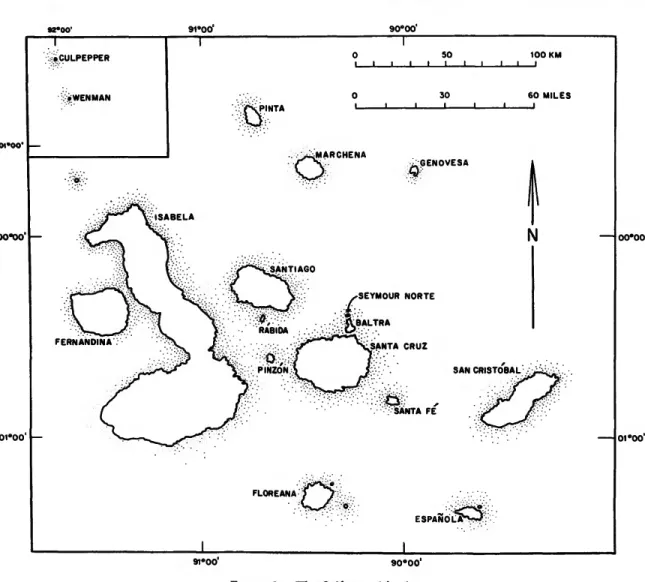
Floreana is located in the south-central portion
of the archipelago (Figure 1). It is the 6th largest island in the group, having an area of 171 square kilometers (66 square miles) (Wiggins and Por- ter, 1971). The highest point on Floreana is Cerro Paja or Cerro de Pajas (Straw Mountain), which reaches an elevation of 640 meters (2100 feet; McBirney and Williams, 1969, pi. 2; Figure 2 herein). Although Floreana is roughly circular in shape and attains its highest elevations near the center of the island, it is not dominated by a single large shield volcano with a caldera. Mc- Birney and Williams (1969:21) noted that a cal- dera may have existed at one time on Floreana, but was obliterated by the many younger cones and flows, thus placing Floreana in the "Mauna Kea stage" of volcanic development. Floreana has many parasitic cones, scattered nearly ran- domly, that vary much in size (McBirney and Williams, 1969, fig. 8). Nearly all of the cones are scoria or lava-scoria cones. In between these cones are pahoehoe lava flows and many types of basaltic ejecta, ranging from ash and cinders up to large boulders. The small satellite islands to the north and east of Floreana are formed from tuff or scoria cones that have undergone differ- ing degrees of erosion.
Most of the surface lavas of Floreana are of the Bruhnes Normal Polarity Epoch (0.0-0.79 million years old, following Johnson, 1982), al- though lavas of the Matuyama Reversed Polarity Epoch (0.79-2.47 million years old) are exposed along the northwestern, northeastern, eastern, and southern coasts (Cox and Dalrymple, 1966;
McBirney and Williams, 1969:22, 106; Craig S.
Bow, pers. comm.; Cox, 1983). Within the Ga- lapagos, Floreana is an island of intermediate age, i.e., one that emerged during the Matuyama Reversed Polarity Epoch (Cox, 1983). Floreana thus is roughly equivalent in age to Pinzon, Ra- bida, and Wenman. It is younger than the old eastern islands, such as San Cristobal, Espanola, Sante Fe, and Santa Cruz, but older than the western and northern islands of Santiago, Isa- bela, Fernandina, Genovesa, Marchena, Pinta, and Culpepper. McBirney and Williams (1969:22) said that "almost surely some [of the
90°00'
00*00'
01*00
.>CULPEPPER 50 100 KM
I I I I i l l
60 MILES VSUP
GENOVESA
SEYMOUR NORTE
FERNANDINA
SAN CRISTOBAL
FLOREANA
a
00*00'
oi'oo1
91°00" 90°00"
FIGURE 1.—The Galapagos Islands.
lavas on Floreana] were discharged within the last thousand years, if not within the last few centuries." I disagree with this statement, for I have never seen fresh lavas on Floreana. Al- though some of Floreana's lavas are still rather devoid of vegetation, they are, nevertheless, much more weathered than are any of the known historic lavas in the Galapagos. McBirney and Williams (1969:22) also mentioned the report from Captain David Porter, of the U.S. frigate Essex, of seeing a volcanic eruption on Floreana in July 1813. Neither McBirney and Williams nor any other geologists, however, have found
any lava or other ejecta suggestive of this activity.
Simkin et al. (1982:98) listed this eruption as
"uncertain (more likely Sierra Negra eruption)."
Volcano Sierra Negra, on southern Isabela, is thought to have erupted in 1813 (Simkin et al.,
1982:98), and Porter's account of the eruption (in Porter, 1822) did not state specifically that it occurred on Floreana (T. Simkin, pers. comm.).
Until contrary evidence is brought forth, the volcanoes of Floreana should be regarded as extinct. Probably there has been no volcanic activity on Floreana for at least several thousand years.
SLA ONSLOW (DEVIL'S CROWN) (II)
•TA CORMORANT PTA DAYLIGHT
RAOA BLACK BEACH
FIGURE 2.—Floreana and its satellite islands (area enclosed by box shown in greater detail in Figure 4; contour intervals in feet; modified from map prepared by CDRS).
Floreana is composed mainly of alkaline olivine basalts. Richardson (1933:61) listed the following rock types from Floreana: "basalt with olivine only phenocrysts, amygdaloidal basalt, basalt scoriae, olivine bronzite lapilli." McBirney and Aoki (1966) and McBirney and Williams (1969:26) reported that plagioclase phenocrysts are rare on Floreana, whereas porphyritic olivine is very common. I have found, however, that phenocrysts of plagioclase, pyroxene, and olivine are all common in the basalts of the Post Office Bay region. Further, Chesterman (1963) re- ported phenocrysts of plagioclase in a rock from Floreana (see below), and Chubb (1933:18) found "felspar" (sic) in large broken crystals near
Post Office Bay. Chemical analyses or detailed descriptions have been published for rock speci- mens from Floreana as follows: Richardson (1933), 4 specimens (porphyritic olivine basalts);
Chesterman (1963), 2 specimens (a crystal-vitric- lithic tuff from Cormorant Bay, and a basalt with phenocrysts of plagioclase and pyroxene from near Black Beach); McBirney and Aoki (1966) and McBirney and Williams (1969:26-28, 123, 131, 132, 158), 4 specimens (a typical alkaline olivine basalt, a dunite inclusion and a peridotite inclusion from the same basalt, and a chrome- diopside from the same peridotite).
As one would expect in a young volcanic ar- chipelago, sedimentary deposits and rocks are
uncommon in the Galapagos. Non-marine sedi- mentary deposits are especially rare. Alluvium occurs as small, unindurated, high-energy depos- its that are, as one would expect, unfossiliferous.
The very porous volcanic soil of the Galapagos promotes infiltration of rain water rather than run-off. The only thorough description of soils in the Galapagos is in Laruelle (1966), based upon an altitudinal sequence on Santa Cruz.
Fine-grained lacustrine sediments are found in crater lakes on San Cristobal, Genovesa, San- tiago, Isabela, and Fernandina. These sediments are described by Colinvaux (1968, 1969), How- miller and Dahnke (1969), and Colinvaux and Schofield (1976a,b), the last authors also report- ing on the fossil pollen and spores from El Junco Lake, on San Cristobal. Bogs are found in the highlands of Santa Cruz, Isabela, Floreana, and perhaps Santiago (Colinvaux, 1968; Hamann, 1975, fig. 2).
Localized marine sedimentary rocks occur on over half of the major islands in the Galapagos.
Hickman and Lipps (1985) have divided the ma- rine deposits into 6 categories (tuff cones with marine fossils; limestone and sandstone interbed- ded with basalt flows; terrace deposits above sea level; beach rock; supratidal talus debris; recently uplifted tidal and subtidal rocks and sand) that correspond to those mentioned by Pitt and James (1983). At Punta Cormorant, Floreana, I have collected beach rock riddled with marine gastro- pods. Previous workers (Hertlein, 1972, and ref- erences therein) have regarded certain of the marine deposits in the Galapagos to be as old as Miocene or Pliocene, but Hickman and Lipps (1985) report that the ages of these deposits range from only several hundred years up to approximately 2 million years, and thus all are probably either Holocene or Pleistocene. These deposits typically are dominated by mollusks, with coelenterates and echinoids also present.
Among the mollusks, gastropods usually out- number pelecypods.
The volcanic rocks that make up most of the Galapagos have been regarded as an extremely poor environment for preservation of terrestrial
fossils. As mentioned above, there is very little alluvial sedimentation, and no exposures of fine- grained, stratified terrestrial sediment such as often contains fossil material on continents. Until recently, therefore, vertebrate paleontology in the Galapagos lagged well behind other branches of geology and biology. Research on fossil ver- tebrates began in the Galapagos only in the past two decades with the realization that caves (lava tubes) can be rich sources of fossils. Niethammer (1964) reported on mammalian bones from owl pellets on Santa Cruz; only the large extinct rodent "Megalomys" (= Megaoryzomys) curioi oc- curred in what might be termed a paleontological context. Ray and Whitmore (1973) expressed the great need for paleontological research in the Galapagos, and through the interest and encour- agement of them and others at the Smithsonian Institution, various field biologists collected bones (mainly of M. curioi) from caves on Santa Cruz and Isabela in the 1960's. These fossils, and others of M. curioi more recently collected, have now been described by Steadman and Ray (1982).
Birds and reptiles, for which the Galapagos are so well known, remained unknown as Holocene fossils until very recently. Based on field work in 1978 and 1980, I reported fossil reptiles, birds, and mammals from Santa Cruz, Floreana, and Isabela (Steadman, 1981). I briefly discussed fos- sils of Darwin's finches from Santa Cruz in re- evaluating the evolution and systematics of that famous group (Steadman, 1982).
CLIMATE.—The climate of the Galapagos has been reviewed by Alpert (1963), Palmer and Pyle (1966), and Hamann (1979), but we still lack a comprehensive treatment of this subject. The Galapagos lie in the "dry zone" of the equatorial Pacific. They are not subject to the violent storms that can readily occur only several hundred miles to the north. The oceanic currents of the eastern equatorial Pacific (reviewed by Wyrtki, 1966, 1967) strongly affect climate in the Galapagos.
Relatively high islands such as San Cristobal, Floreana, Santa Cruz, and Santiago, have a cli- matic gradient characterized by increasing pre-
cipitation and decreasing temperature as the al- titude increases. (The large, very high islands of Isabela and Fernandina do not quite fit this gen- eralized pattern.) For Floreana, Hamann (1979) reported mean annual precipitations of 214.1 mm at the "En la Playa" station (= Black Beach;
elevation 4 m; on the western coast) and 806.0 mm at the "Asilo la Paz" station (= Wittmer Farm; elevation 300 m; on the south-central part of the island). The number of years upon which these means were based was not given, nor were any temperatures. Cruz and Beach (1983) re- ported two years of data on rainfall and wind direction from five weather stations on Floreana.
Their results are discussed below in connection with El Nino.
There are two principal seasons in the Gala- pagos—the rainy season lasting approximately from January through April, and the dry season that makes up the rest of the year. The distinc- tion between these seasons is pronounced, in both the arid lowlands and moist highlands. The rainy season is a period of contrast, as the most precipitation as well as the hottest, sunniest days occur at this time. The dry season is character- ized by a fog or mist known as "garua." The frequency and intensity of the garua varies from year to year. Typically, the garua is more persis- tent in the highlands than in the lowlands. The weather patterns of the Galapagos may be sum- marized as follows (based mainly on Alpert 1963, and Hamann 1979).
Rainy, Hot Season: January-April; ITCZ (In- tertropical Convergence Zone) moves southward to just north of the Galapagos (usually 1 °-2°N);
air pressure is relatively low; relatively warm temperatures (at sea level, CDRS weather station, Santa Cruz, mean = 25.9°C, max. = 27.9°C, min. = 24.1°C; at 194 m elevation, Bella Vista weather station, Santa Cruz, mean = 24.0°C, max. = 24.8°C, min. = 22.6°C); temperature inversion weakens or dissipates; rain showers at midday, especially in higher parts of the islands;
high levels of sunlight; good visibility, especially in the morning; relatively low wind velocities;
dominant wind direction east or east-northeast;
low cumulus and altocumulus clouds typically present; cumulus clouds moving from easterly direction.
Dry, Cool Season: May-December; ITCZ is well north of the Galapagos (approximately 10°N); air pressure relatively high; relatively cool temperatures (at sea level, CDRS weather station, Santa Cruz, mean = 22.7°C, max. = 27.6°C, min. = 18.8°C; at 194 m elevation, Bella Vista weather station, Santa Cruz, mean = 20.6°C, max. = 24.5°C, min. = 17.8°C); low- level temperature inversion operative; often overcast with poor visibility, especially in the morning; usually good visibility in the afternoon, at least in the lowlands; fog, mist, or drizzle (garua) forms in the morning and usually dissi- pates before noon, but often persists in the high- lands; very little measurable precipitation at lower elevations, but garua may produce meas- urable precipitation in the highlands; dominant wind direction southeast or east-southeast; stra- tocumulus and altocumulus clouds typically pres- ent; stratocumulus clouds moving from southerly or southeasterly direction.
Changes in temperature, whether seasonal or daily, are not extreme in the Galapagos. For example, on low and barren Baltra, the mean daily maximum and minimum for March (the warmest month) are 31.1 °C and 23.9°C, while the same for September (the coolest month) is 26.7°C and 18.9°C (Alpert 1963). (I have con- verted all of the figures in Alpert (1963) and Cruz and Beach (1983) from Fahrenheit to Cel- sius, and from inches to millimeters.) The rela- tive consistency in temperature is contrasted, however, by a great variability in precipitation.
At Wreck Bay on coastal southwestern San Cris- tobal, Alpert (1963) reported that the annual rainfall for 1950-1958 varied from 37.1 to 1424 mm (mean = 503 mm), while mean monthly rainfall varied from 4.3 mm (June) to 151.4 mm (February). Rainfall also varies greatly from year to year for any given month in the rainy season.
Alpert (1963) reported 1.5 mm for February 1950, compared to 487 mm for February 1953, and 0.0 mm in April 1952 and 1954, compared
to 458 mm in April 1953. Indeed the "rainy"
season in the Galapagos can be extremely arid in some years. For the weather station at Wreck Bay, mean precipitation during 1950-1958 was 417 mm in the rainy season (January through April) and only 86 mm in the dry season (the remaining 8 months).
"El Nino" refers to the sudden appearance of anomalously warm surface water in low latitude regions of the central and eastern Pacific, espe- cially along coastal regions of Peru and southern Ecuador, westward through the Galapagos. The waters of this region are normally much cooler because of upwelling of cool sub-surface waters, as well as the influence of the cool surface waters of the northward flowing Peru current. El Nino can last from several months to nearly two years.
It is not an annual event, but occurs at irregular intervals of 1-12 years (Quinn and Burt 1970).
The years 1828, 1845, 1864, 1871, 1877-1878, 1891, 1904, 1918, 1925-1926, 1929, 1932, 1939-1941, 1943, 1953, 1957-1958, 1965- 1966, 1972-1973, and 1982-1983 are generally regarded as years of well-developed El Nino ac- tivity (Alpert, 1963; Quinn and Burt, 1970; Ra- mage, 1975). The actual cause of El Nino is controversial and beyond the purposes of this paper.
El Nino normally sets in during January to March, although it can begin as early as October or as late as May (Wyrtki, 1975; Wooster and Guillen, 1974). Sea surface temperatures in the Galapagos are highest from January through March regardless of the presence or absence of El Nino, because of increased solar radiation associated with the austral summer, as well as a southward shift in December to February of the warm tropical surface water that otherwise oc- curs north of the Equator (Wyrtki, 1966). During times of El Nino, however, sea temperatures are extremely high. This warm water is less saline than the displaced, cooler water. Many climato- logical and oceanographic phenomena of the 1972-1973 El Nino, the best documented severe El Nino until that of 1982-1983, are described by Wooster and Guillen (1974) and Ramage
(1975). The extremely severe El Nino of 1982- 1983 is described in detail by Cane (1983), Ras- musson and Wallace (1983), and Barber and Chavez (1983), and many other papers are ap- pearing on this topic.
Heavy rainfall in the Galapagos and coastal Peru and Ecuador is associated with El Nino.
Cruz and Beach (1983) have documented the drastic increase in precipitation on Floreana dur- ing the 1982-1983 El Nino. At Black Beach they recorded only 4 mm per month from June through November 1982, but an astonishing 316 mm per month from December 1982 through March 1983. Extremely heavy rainfall occurred on mainland Ecuador and throughout the Gala- pagos during the 1982-1983 El Nino, enough to form streams and pools in areas of the Gala- pagos that never before experienced surface water (personal observation). Marchant (1958, 1959) noted that the great majority of nesting in terrestrial birds of Ecuador's arid Santa Elena Peninsula occurred directly after periods of sig- nificant rainfall. Rates of successful avian repro- duction were much lower in 1955-1956 than in the El Nino interval of 1957-1958. The same heavy rainfall that means highly successful repro- duction for terrestrial birds spells disaster, how- ever, for the marine birds of the Galapagos and coastal Peru and Ecuador. The most famous biological consequence of El Nino is a massive mortality in fish (especially anchovies), whose planktonic food resources have been altered by the lack of adequate upwelling of cool, phos- phate-rich waters. This results in large-scale mor- tality among marine birds that feed on the fish (Murphy, 1936:101-108; Wyrtki, 1966;
Boersma, 1978). During the 1982-1983 El Nino, the nesting success of land birds in the Galapagos was truly phenomenal, as was the lack of repro- duction in the seabirds. Many of these events were well monitored by biologists, whose reports should be forthcoming in the next year or two.
PALEOCLIMATE.—On the basis of sediments from El Junco Lake on San Cristobal, Colinvaux (1972) postulated that the Quaternary of the Galapagos was characterized by dry glacial inter-
vals and relatively wet interglacials. This was substantiated further by the pollen and spores from these sediments (Colinvaux and Schofield, 1976a,b). The organic sediments of the past 10,000 years in El Junco were underlain by un- datable inorganic sediments that contained a lens of organic sediment dated at >48,000 years B.P.
The physical and chemical nature of the inor- ganic sediment suggested alluvial deposition in a dessicated lake bed, rather than typical lacustrine deposition. To account for the apparently dry conditions indicated by the inorganic sediments, Colinvaux (1972) theorized that the ITCZ was north of the equator during the entire year in glacial times, and therefore was unable to pro- duce the rains from January to March or April that characterize its annual southward movement today. The unstable, mixing air of the ITCZ is responsible for any "normal," heavy rainfall to- day in the Galapagos, as well as in adjacent areas to the north where the ITCZ is present for more than several months. El Nino may be only a very intense southward movement of the ITCZ, which would involve a southward displacement of the Equatorial Countercurrent and the South Equa- torial Current. If this is so, then El Nino probably did not affect the Galapagos during Pleistocene glacial intervals, and Colinvaux's theory is cor- roborated. If El Nino has a less obligatory rela- tionship to the ITCZ, such as in the causal theory of Wyrtki (1975), then El Nino still could have influenced the climate of the Galapagos during glacial advances.
The suggestion by Colinvaux (1972) of a more northern ITCZ in glacial times touched off sev- eral responses by researchers who did not ques- tion that the Galapagos were probably more arid during glacial intervals, but who instead pro- posed different mechanisms to account for this aridity. Newell (1973) was the first to challenge Colinvaux's theory, suggesting that Pleistocene aridity could be attained through the ITCZ re- maining south of the equator instead of north.
Newell's statement is based upon the relationship between modern seasonal, latitudinal tempera- ture gradients, and the modern seasonal posi-
tions of the ITCZ, with the southward dis- placement of ITCZ increasing with increasing temperature gradients, especially those of the Northern Hemisphere. Newell (1973) used 18O/
!6O data from ice cores to state that latitudinal temperature gradients at 20,000 years B.P. were much higher that those of any season today, thus the southward displacement of ITCZ at 20,000 years B.P. was greater than even the largest south- ward seasonal displacement today. A major flaw that I see in Newell's hypothesis is that a southern movement of the ITCZ would result in wetter, not drier, conditions in the Galapagos. (For ex- ample, see the rainfall map in Palmer and Pyle, 1966.) Houvenaghel (1974) stated that the higher temperature gradient of glacial times re- sulted in stronger southeasterly trade winds that increased both the rate and duration of upwelling of cool water in the Galapagos. This would result in drier weather than at present, without involv- ing a southward shift in the ITCZ. Simpson (1975) proposed a model for glacial climates in the eastern tropical Pacific, and in doing so, she discounted the models of Colinvaux, Newell, and Houvenaghel as being largely unsubstantiated and ignorant of relevant data. However, Simp- son's "all-encompassing" model called upon the upwelling of cool water in the Galapagos and coastal South America, just as the model of Hou- venaghel (1974). Although Simpson's method- ology was somewhat different from Houvenagh- el's, the two models do not seem incompatible, and each deserves testing from other workers.
VEGETATION.—The major botanical surveys of the Galapagos are those of Hooker (1847), B.L. Robinson (1902), Stewart (1911), Svenson (1935), Wiggins and Porter (1971), and Hamann (1981). My description of Floreana's diverse veg- / etation is based upon the last two references, supplemented by my own observations. The na- ture of the vegetation in the Galapagos is con- trolled largely by precipitation, which in turn is controlled mainly by elevation, directional ex- posure, and size of the island (Alpert, 1963). On the higher islands, such as San Cristobal, Santa Cruz, Floreana, Santiago, Isabela, Fernandina,
FIGURE 3.—Arid zone vegetation on Floreana during dry season, October 1980 looking northeast toward Punta Cormorant from entrance to Cueva de Post Office (Inferior) (leafless trees are Bur sera graveolens).
Pinzon, and Pinta, clear-cut altitudinal changes in vegetation are evident. Wiggins and Porter (1971) divide the vegetation of the Galapagos into 6 zones: littoral, arid, transition, Scalesia, Miconia, and fern-sedge. Excellent photographs of these vegetational zones are found in Wiggins and Porter (1971) and Hamann (1979, 1981).
Floreana may have each of the 6 zones, although the status of the Miconia and fern-sedge zones is \ uncertain because of the severe alteration of the highland vegetation. Hamann (1981:20) divides the Galapagos plant communities into 9 broad categories, most of which have two or more subdivisions. They are: forest; closed scrub with scattered trees; scrub; steppe forest (woodland);
steppe scrub (scrub woodland); shrub steppe sa-
vanna; desert scrub; broad leaved herb vegeta- tion; and closed bryoid vegetation.
All of the fossil sites are in the arid lowlands, so only that type of vegetation will be described.
I will stress woody plants because of their impor- tance in the physiognomy of the vegetation. Spe- cies marked with an asterisk (*) are particularly dominant or conspicuous, at least locally. The arid zone (Figure 3) covers more area on Flo- reana than any other vegetational zone. It occurs from near the coast (just in from the littoral zone) upslope to elevations from approximately 80- 120 m on the south-facing side of the island to 200-300 m on the north-facing side. The highest diversity of shrubs and small trees is found in the arid zone. Most of these species are deciduous,
resulting in a drastic change in the appearance of the arid zone in the rainy versus the dry season. Many of the trees and shrubs are spiny and have relatively small leaves. The trees are spaced rather evenly and far apart, giving this region an open appearance. Soil occurs only in isolated, shallow pockets; most of the surface is barren basaltic rock. Two large arborescent cacti (*Opuntia megasperma and *Jasminocereus thouar- sii) occur in this zone and may be the tallest plants present. These cacti have been reduced in numbers by feral mammals. As a result, the tree
*Bursera graveolens is by far the most conspicu- ous plant today in the arid zone of Floreana. The following other species of trees and shrubs occur in the arid zone: Acacia macracantha, A. rorudi- ana, Alternanthera echinocephala, Borreria dis- persa, B. linearifolia, Castela galapageia, Chamae- syce nummularia, C. punctulata, C. viminea, Cler- odendrum molle, Cordia leucophlyctis, *C. lutea, C.
revoluta, *Croton scouleri, *Cryptocarpus pyrifor- mis, Desmanthus virgatus, Geoffroea spinosa, Gos- sypium barbadense, Lantana peduncularis, May- tenus octogona, *Parkinsonia aculeata, *Prosopis juliflora, *Scalesia affinis, *S. villosa, *Scutia pau-
ciflora, Vallesia glabra, and *Waltheria ovata.
The Fossil Sites
THE CAVES.—The four fossiliferous caves (lava tubes) are all very close to one another and can be reached on foot from the Post Office Barrel in under 20 minutes (Figures 4, 5). A tourist trail, constructed in 1980, now leads to Cueva de Post Office (Inferior). The elevations of the caves, at their entrances, range approxi- mately from 20 to 50 m. Blockage from roof collapses made it impossible to reach the true origin or termination of the lava tubes. The flow that contains the four caves is of relatively youth- ful pahoehoe lava thought to be derived from a large scoria cone approximately 2 miles (3.2 km) SSE of Post Office Bay (McBirney and Williams, 1969:22, 25). This lava is of the Brunhes Normal Polarity Epoch, and thus is no older than 0.79 million years (see "Geology"). I am not aware of
any potassium-argon age determinations from the Post Office Bay region to complement the paleomagnetic information. Many pressure ridges and mounds also occur in the Post Office Bay region.
Cueva de Post Office was named, mapped, and described by Montoriol-Pous and Escola (1975).
Although it is actually a single lava tube, the two entrances to this cave lead to separate passage- ways ("Inferior" and "Superior") that are blocked from each other by a massive roof collapse, with the southern end of "Inferior" being separated from the northern end of "Superior" by a talus cone of boulders (Montoriol-Pous and Escola, 1975, fig. 2A). The entrances are formed by smaller roof collapses and are such that escape would be impossible for any large, non-volant animal that fell into them. Cueva de Post Office (Inferior) (Figures 6-8) runs downslope to the sea, its lower portion being inundated by salt water. Large boulders of roof spall are very common in the southern portion of Cueva de Post Office (Inferior), especially in Room 2 and in the low-roofed area separating Room 3 from Room 4. North of Room 2, most of the floor of the cave is barren basalt, free of any sediment.
In Room 2 and south thereof, much of the floor is often covered by poorly sorted sediment rang- ing in size from clay to boulders. In Cueva de Post Office (Superior) (Figures 9, 10), thick de- posits of poorly sorted clays to boulders cover the entire floor.
Finch Cave and Barn Owl Cave have not been named, mapped, or described previously. Miguel Pozo and I discovered Finch Cave (Figures 11, 12) in 1978. The entrance to Finch Cave is the highest roof collapse that I have found in the Galapagos, being a drop of 18 m to the floor of the cave. A large, bouldery talus cone of roof spall dominates the area below the entrance. The southeastern edge of the talus cone is met by a talus slope originating from roof spall concen- trated in the southeastern portion of the cave (only partially mapped). As with most thick talus accumulations in caves on Floreana, these slopes have a dip of 30 °-35 °. The original basaltic floor
BAHIA POST
OFFICE
• CUEVA DE POST OFFICE (INFERIOR) CUEVA OE POST OFFICE (SUPERIOR)
FIGURE 4.—Post Office Bay region, showing location of four fossiliferous caves (contour intervals in feet).
FIGURE 5.—Post Office Bay, looking southeast toward Floreana (all fossil caves located between beach and prominent scoria cone just behind beach).
FIGURE 6.—Plan view of floor of Cueva de Post Office (Inferior) (note entrance (Figures 7, 8) and location of Excavations 1-3 in Room 4 (Figures 15-17); modified from Montoriol-Pous and Escola, 1975).
Finch Cave. Essentially unfossiliferous, fine- grained sediments (mainly clays and silts) occur in the low-lying sections of the North Room of Finch Cave. These sediments appear to be de- rived from soil that periodically washed into the cave via the roof collapse, for they are darker and better sorted than the fossil-bearing sedi- ments excavated from the other three caves.
Barn Owl Cave (Figures 13, 14) was discovered by James R. Hill on 30 October 1980. This cave is more diverse faunally than any of the other caves, but because we already had scheduled a boat to take us from Floreana on 1 November 1980, our paleontological endeavors in Barn Owl Cave were limited to two hurried days. Much of Room 1 is exposed to the surface by a huge roof collapse that did not, however, allow as easy access to the cave as the entrance in Room 2.
Essentially the entire floor of Barn Owl Cave is covered by some sort of sediment, ranging from
FIGURE 7.—Looking northeast out of entrance of Cueva de Post Office (Inferior), October 1980, from Room 1 toward Maria Jose Campos above ground.
FIGURE 8.—Entrance of Cueva de Post Office (Inferior), October 1980, looking south (Maria Jose Campos and Ed- ward N. Steadman wait to enter).
CUEVA DE POST OFFICE (SUPERIOR)
10 METERS
FIGURE 9.—Plan view of Cueva de Post Office (Superior) floor (note Excavations 1-4(1 and 2 detailed in Figures 18, 19); entrance (Figure 10) straddles boundary between areas 2 and 3;
modified from Montoriol-Pous and Escola, 1975).
FIGURE 10. —Entrance of Cueva de Post Office (Superior) Maria Jose Campos, October 1980;
because of diagonal orientation and smaller size, entrance was ineffective as a natural trap for large tortoises.
FINCH CAVE
O 20 M.
SOUTH TALUS SLOPE UNMAPPED PORTION OF LAVA TUBE—1-
mainly boulders on the talus slopes to various fine-grained sediments in low-lying areas. For example, the talus slopes in Rooms 1-3 are com- posed mainly of angular basaltic pebbles and boulders up to 1.2 m in diameter, whereas much of the floor of Room 3 is covered by loose, fine sediments (clays through sands). Sediments of many particle sizes (clay through pebbles) occur near the edges of the talus slopes, such as at Excavation 1.
STRATIGRAPHY.—Near the entrance, the floor of each cave was littered with hundreds of bones, as well as pieces of wood. I dug five small test pits in the sediments of Cueva de Post Office, stratigraphic profiles of which are shown in Fig- ures 15-19. Careful sorting of the fine fraction of the matrix yielded a fair number of small, often fragmentary, fossils. With minor excep-
FICURE 11.—Plan view of Finch Cave floor.
FIGURE 12.—Looking into Finch Cave, October 1980 (James R. Hill stands at bottom (arrow), near edge of main talus cone).
W:
tions, the fossils within the sediments are of the same species as occur on the surface of the floor.
The sediments from the different test pits are broadly similar to each other. They are very inorganic, being derived from basalts, with some secondary minerals (gypsum, flourite, apatite, minor calcite). De Paepe (1967) and Montoriol- Pous and Escola (1975) reported gypsum, flour- ite, and apatite as secondary minerals from Cueva de Post Office (Inferior). Gypsum has been re- ported elsewhere in the Galapagos from the salt deposits of Tagus Crater Lake, Isabela (How- miller and Dahnke, 1969).
The occasional indistinct stratigraphic units in these poorly sorted clays to pebbles are sugges- tive of very brief water transport, although the lack of well-developed laminations, in combina- tion with the angular nature of the clasts and the
FIGURE 13.—Plan view of Barn Owl Cave floor (note Excavation 1, shown in Figures 20, 21).
FIGURE 14.—Entrance of Barn Owl Cave, May 1983 (Gayle Davis and Godfrey Merlen prepare to enter).
I
. •
CUEVA DE POST OFFICE (INFERIOR)
EXCAVATION 2
CUEVA DE POST OFFICE (INFERIOR)
EXCAVATION 3
CUEVA DE POST OFFICE (INFERIOR)
EXCAVATION 1
X X X X X X X X X X X 1 0 -
15 X X X X A x x x
u -
10 -
2 0 -
3 0 -
4 0 -
5 0 -
6 0 -
it Si
• ° ;:' • . • . * • ' • ° ' -
~r.~rZ/r~.—/r
$**$&
••.cb<Ox x
~&G~ar
x• Q'Zyv' x x
•O.7?-
C!/x X
': '9,Q:tX X X
:§••
f X X
X X X X X X X V
FIGURE 15.—Stratigraphic profile of Excavation 1, Cueva de Post Office (Inferior), Isla Floreana, Galapagos (descrip- tion of sediment: light yellowish brown (10 YR 8/4 dry), light brown (7.5 YR 7/6 wet), unlaminated, poorly sorted;
slightly silty, slightly sandy gravel; contact poorly defined (dashed line); clasts of basalt and flourite, very angular to sub-angular, averaging smaller in the top 1 cm; slight reac- tion with 10% HC1; no fossils in upper 6 cm; maximum observed thickness = 11 cm; lower contact basaltic bedrock).
FIGURE 16.—Stratigraphic profile of Excavation 2, Cueva de Post Office (Inferior), Isla Floreana, Galapagos (descrip- tion of sediment: light yellowish brown (10 YR 6/4 dry), dark reddish brown (5 YR 3/3 wet), unlaminated, poorly sorted: pebbly, sandy, silty clay; contact poorly defined
(dashed line); clasts of basalt and gypsum, very angular to sub-angular, averaging smaller in the upper 3 cm; reaction with 10% HC1; maximum observed thickness = 15 cm; lower contact basaltic bedrock).
FIGURE 17.—Stratigraphic profile of Excavation 3, Cueva de Post Office (Inferior), Isla Floreana, Galapagos (descrip- tion of sediment: yellowish brown (10 YR 5/6 to 10 YR 5/
4 dry), reddish brown (5 YR 4/4 wet), poorly laminated, poorly sorted; pebbly, slightly sandy, slightly silty clay, alter- nating with slightly pebbly, slightly sandy, slightly silty clay;
poorly defined contacts (dashed lines); basaltic clasts, angular to sub-angular; reaction with 10% HC1; maximum observed thickness = 63 cm; partial lower contact basaltic bedrock).