The opinions expressed in this article are my own and should not be considered an official statement of the Department of the Air Force. The first of the three main parts of this thesis is a step-by-step development of the data structure and the associated algorithm. The appendices, with one exception, are an overview of the programs in use at SAC during the past year.
Appendix B contains a detailed description of a distance calculation function or metric used to calculate geodetic distances on the Earth's surface. The first file that was examined consists of approx. 50,000 records describing points on the Earth's surface.
CHAPTER III
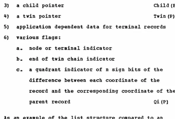
The stars in the twin marker column indicate the end of the ring, i.e. the parent cursor. I am outside; record(!) to be inserted was within the line segment defined by node(P') and was on the Q side of the center of that segment. The overhead generated by the tree structure is a. direct result of the node records that define the structure.
Note that in the case of the rectangle, the intervals defining the sides are closed at each end. At least part of the rectangle is outside the square if the intersection of X and ~A is not e•pty.
CHAPTER V
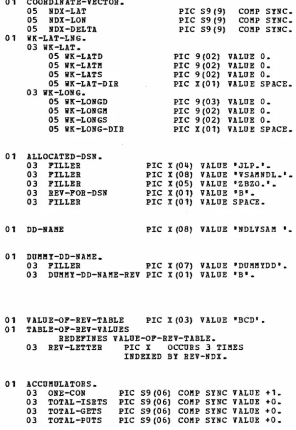
The eight-byte logical name of the file to be processed is stored in DDBAME. The current length in bytes of the character string in the user data area is set in the TODL field. The RBA of the new terminal record is returned for use by the driver program as desired.
Any record in the Cartesian file can be DELETED except the master master record. A nuaerical error code [3, page. 58-60) of the operating system is also placed in the RBA field of the communication block.
CHAPTER VI
PRIORT Points to the top of the priority ring that is maintained for the site directory (DIREC@) in a recently used (LRU) mode. The translation is completed by adding LODEDSP to the page frame address to arrive at the main address of the data register memory being referenced. The parameters for PGRLSB are the low address and the high address plus one of the areas to be released; these addresses are exactly the page frame addresses as stored in the page directory for the page slot being issued along with the address of the next slot.
SETFLGS carries the results of the crossover function set while QSTBH and QSTRL are set by arith-. QSTRO is only used during insertions to adjust the coordinates of the new node record being built as a parent. QSTRI would be one equal to the start of the Q bit string in the record, but, because of the variable length of a coordinate vector, is stored as a value equal to COORDSi plus the length of a coordinate vector.
RPLasG is an overlay of the last 132 bytes and is only used by VSAM to return an error message. If the CI is already in memory, it is logically moved to the top of the LBU ring, the offset is added to the correct frame address in Rl, the delta is extended, the twin pointer from• entry is inserted into R2, and control is returned to the calling point. The stack pointers are reset to set the aaster RBA in the master position (-1} for the stack, which is then aligned with twin and child pointers as usual.
If the record is a node and the fourth position of the function code is a "Lft, a branch is taken to the top of this code section to immediately retrieve the next record. This new node becomes the parent of c and the new terminal X and the coordinate values of the new node is adjusted to ensure that C and X have different Q strings relative to their new parent After the pointers have been adjusted, the length of the chain is examined to ensure that the chain is at least two mebs long.
CHAPTER VII
It looks like you could get a better estimate of the radius for the circumcircle by using VECTOR to measure the distance from the center of the square to its left corner, for example. Unfortunately, some nodes near the root of the tree have latitude values in the range of 1450. Since the villa search strategies.1 do not attempt to precisely determine the inclusion of the area within the square defined by the node, rather the reverse, the upper limit approach with the selected E village.
As a first approximation to the desired circle with center coordinates (latO, lnqO), define a search rectangle. The delta latitude value is the correct number of arcseconds equivalent to the radius of the circle (DO), while the delta longitude is the same number of arcseconds divided by the cosine of the latitude to allow for convergence at the poles. The input is the Cartesian Index file to be searched, and a file of control cards, each containing the latitude and longitude of the center of a search circle.
An obvious extension of the circle search is a search for those installations within the area defined by the atheatic union of k circles as shown in figure 7-3a. We modify algorithm cs by defining the search rectangle to include all circles and check distances to the center of each circle instead of just the one; By initially setting a flag to indicate •outside-all-circles•, a loop is performed on the metric. Since CARTAft leaves the limit vectors available to the driver program at all times, a soaevhat more extensive.
When this algorithm finishes, the last record stored in the terminal will be the closest terminal to the initial search coordinates. Conceptually, the terminals in the direction of the upper right quadrant) are examined sequentially, reducing the size of the search circle (perhaps) each time, until the nearest terrain in that quadrant is found. If a certain area of the world were to be displayed whenever maps were requested, it would be a simple matter of building a sub-image to be displayed and called from secondary storage as needed.
CHAPTER VIII
SETA 1 SETA 15
- PRNTDEL PRNTDEL
- DELWK SET&l!.7
OFFSET FOR EX IN BTNVALS OUTER LOOP OFFSET IN F4A IBBER LOOP OFFSET IN F4A LOOP OPFSET IN INTRSECT.
PUNCH I PAGE CARTA!!'
TITLE I
TITLE 1 PROGRA!! TO BANDLE N-DI~ENSIONAL INDEX *
B15,=AL2(-L1STACK) GET DIRECTLY R14,STKTOP CHECK STACK TO SEE RO,CBRBA IP IT'S THERE STKTOP,STKTOP.
TITLE 1 PROGBA" TO BANDLE N-DII!ENSIONAL INDEX INSERT FUNCTION'
- STAT DUPLICATE RECORDS; NO INSERTION RO,STACK (R10)
BCDPLGS(R1),X'PF1-PARENT BCD JUST CONNECTED TO RCDFLGS+NODEAREA,PABENT WAS END OF DOUBLE CHAIN XTBD2.
LONE12
VECTOR is a subroutine written as an implementation of the Schrieter-Thoaas method for calculating the large elliptic distance and azimuth of the normal section between two arrays. If the results of the distance and azimuth calculation are to have any meaning, the terrain points used as basic data must be geodetically connected, i.e. endpoints must be derived from field survey tents originating from a fixed point and calculated along a common surface (ellipsoid) • The starting point is usually determined by latitude and longitude, either astronomical or geodetic, and the ellipsoid by parameters a and b. Geoaetically, this means that the geoid and ellipsoid surfaces coincide at this point and a fixed initial position is common to both surfaces.
For the geodist i t means that the norital of the ellipsoid coincides with the local vertical at that point and the components of the vertical deviation are zero. The results would be in error, and the magnitude of the error would correspond to the effect of differences in their initial data amounts. To use these for computational purposes is to assume that the two surfaces are congruent and the definition of each point is identical on both surfaces.
It is difficult to say exactly what effect such points produce. would have on the accuracy of the final results for the length and azimuth of the line. The following derivation was extracted from the ACIC report, rearranged and expanded to better relate to the actual subroutine. symbols in capital letters are actual labels of variables as they appear in VEKTOR for the aost part. Because of the ratios of tangents that are calculated, points that are exactly on the equator {0°} and mathematically.
However, a latitude close to the equator can be specified as approximately 10-10 arcseconds to avoid the division-by-zero condition. There is one exception: if the latitude and longitude are specified as arcradians, and the distance is queried with double precision, then the latitude and longitude are also assumed to be double. The results are always returned as floating point values, either single precision/coap-1 or double precision/coap-2, as requested by the characters of i•. The alias RADVEC can be used in place of VECTOR in any of the calls described.
BESSEL
PIC X
CALL 1 ALLOCD 1 USING RETURN-STATUS, DD-NAME,
- PIC 59 (8) COMP
- MOVE 24 TO MAX-OSER-AREA-LENGTH
- CALL 1 CARTAM 1 USING COMMUNICATION-BLOCK
- CALL 1 CARTA1'! 1 USING COMMUNICATION-BLOCK, KEY-FEEDBACK-AREA,
- G-DISPLAY
- DISPLAY 1 CELL(', NUMBER-VSAM-READS, 1 ) = 1 ,
- G-CELLS (NUMBER-VSAM-READS)
- MOVE 88-DISCABD-SUBTREE TO FUNCTION-CODE-4 ELSE
- MOVE 88-CONTINUE-WALK TO FUNCTION-CODE-4
- CALL 1 CARTAM 1 USING COMMUNICATION-BLOCK, KEY-FEEDBACK-AREA,
- CALL 1 VECTOR 1 USING LATO LONO LAT1 LONl
CALL 1VECTOR1 USING LATO LONO LAT1 LONl LAT1 LONl DSTNCE1 !FLAG MOVE CORR NDL KEY TO IGZ OUT. DIVIDE DSTNCE1 BY ANSWER-FACTOR THAT GIVES DIST-OUT MOVE LOW-VALUES TO NO-FLAG WRITE PRINT-REC FROM RESULT-RANGE.
03 FILLER LAT PIC X. LONG LOW HIGH
CALL 1 TIMEAX 1 USING INTERVAL
CALL 1 CARTA8 1 USING COMMUNICATION-BLOCK
MOVE 88-CONTINUE-WALK TO
IP (NOT NODE) AND (ISL NOT < MIN-ISLE-NUM . AND NOT > MAX-ISLE-NUM) MOVE LOW-VALUES TO NONE-FLAG. MOYE NDX-LAT TO LAT-LNG-WORK AREA MOVE 1N• TO LAT-NS OP LAT-OUT. DIVIDE LAT-LNG-WORK-AREA INTO SIXTEEN BY DIVIDING LAT-DEG AND LAT-OUT REMAINING LAT-MIN AND LAT-OUT.
MOVE 1W1 TO LON-EV ON LON-OUT MOVE NDX-LON TO LAT-LNG WORK AREA MOVE 1E1 TO LON-EV ON LON-OUT. DIVIDE LAT-LNG WORK AREA BY SIXTY BY LONGITUDINAL DEGREE OF LEARNING RESANT LON-BIN OF LON-OUT.