We have reached the point where a largely unregulated mix of government, non-profit and corporate agencies have access to vast amounts of location information that is obtained daily for a significant portion of the world's population. In mid-June, the Organizing Committee hosted an in-person Summit (sponsored by Esri), bringing together a variety of disciplines, including social scientists, computer scientists, humanists, and legal researchers and professionals, to further discuss location information and the public interest. They represent a range of positions from junior to senior with different specializations, skills and situations, all driven by the goal of more ethical use of location information.
Very simply put, location data is data about “where?” Locations can be measured using one of several. Some ethical issues are specific to this type of data and will not arise when using data that is not location-based. This problem will arise whenever data is used to address social issues, and these considerations are not specific to the location-specific focus of the Summit.
As in-person gatherings were challenged during the global COVID-19 pandemic, the organizing committee decided to foster conversations about location information and public interest by hosting a series of online webinars.
Research Agenda on Locational Information and the Public Interest
The Census Bureau must aggregate reporting areas such as counties or census tracts to protect confidentiality or have location information removed. Thus, in developing a research agenda on location information, it is important to be aware of the uses to which they are put and the uses that are likely to develop in the future. How to ensure that users of the infrastructure or system receive adequate training on the ethics of data confidentiality and the strengths and weaknesses of different methods of protecting geographic privacy.
How to ensure that users of the infrastructure or system receive adequate training on privacy and data protection. How awareness of the need to protect privacy can be incorporated into the professional codes of ethics of various communities. In some extreme cases technologies may be designed with deliberate intent to disrupt and without public involvement.
Is it possible to develop a humanistic approach that can uncover the life cycle of location information and the interests of the public involved.
Educator’s Guide to Integrating Location Ethics into the Curriculum
Integrate conversations and materials about ethics into many of the learning experiences offered in a course, and don't cram them into a single session or lesson. Present the ethical issues arising from location data and the technologies associated with location data, with a critical understanding of the context in which location data is collected, analyzed and visualized, and in which the location information produced is acted upon. When using a project-based pedagogy, encourage consideration of the ethical issues that arise with each decision made across the project's life cycle.
Start by raising and contextualizing the public's awareness of the extent to which location data is being collected about themselves and others. We expect that many students will have a broader awareness of the question, but may not be aware of some specific questions. The successful integration of ethics into any learning experience depends on students' awareness that technologies that collect location data are not inherently positive, negative, or neutral.
Knowing how to act in different situations is central to critical engagement with these issues and to the development of the skills students need to make ethical decisions in the future. When they are empowered to use the data they have collected in a communication tool, such as an infographic, dashboard or story map, as a means of explaining the patterns of the data they have collected and prompting action as a result of the patterns revealed through their fieldwork. The location data problem presented has no clear solution, but rather has several solutions, each of which is unsatisfactory in some way and leaves a residue unsolved; for example survival tracking of stalking survivors vs.
Clearly, much work remains to be done, but ethics provides a potentially fertile ground with other disciplines to explain the merits of a geographic approach across the academy, beyond the results of data- or tool-based methods. This is another illustration of the lack of awareness and misunderstanding of the value that a geographic approach brings to teaching and research in academia. This implies the need to read and write critical histories of location data or reports on the present (eg as corporatized).
Educators should include these engagements across course topics rather than relegating them to a single class period at the end of the semester. These can be learned in meaningful ways that involve the practical use of the geotechnologies themselves and the geospatial data being examined.
From Ethical Locational Principles to Enforceable Geospatial Regulations
The audit would be comprehensive in relation to the private and public sectors and would include accountability for companies doing business outside the US. It would hear and determine alleged violations of rules and standards and issue remedies for those violations. This is because regulation must account for what has become a global and trans-jurisdictional supply chain of the geospatial ecosystem.
A general informed consent requirement should notify individuals of the purpose, intent, and use of the geospatial data to be collected, along with providing individuals with the ex ante choice to consent to such surveillance and use. such or the refusal of a service or work. However, it is not feasible to set individual negotiations on the parameters of the use of geospatial data; such a mandate may be warranted when geospatial data of other communities or groups is being collected or used. The scope of geospatial data collected and used by governments, businesses, employers and others in positions of authority should be limited to specifically articulated purposes, and nothing more, after informed consent.
A related issue is related to the protection of the rights of workers involved in the development of geospatial software and all related services throughout the supply chain. Regular reassessment of entities' compliance with geospatial data regulations is important to ensure that changing conditions do not undermine the objectives of the regulations. Alternatively, one or more existing government agencies (eg, in the US, the Federal Trade Commission [FTC] or the government procurement system, the Environmental Protection Agency [EPA], the EEOC, or the NLRB) are responsible for enforcing the new regulations.
A first approach would seek cooperation with international and supranational organizations to harmonize the regulation of location data across different areas (e.g. the United Nations International Telecommunication Union, the ILO, the World Trade Organization and the European Union). The second approach would be to design and enforce rules that would make domestic companies responsible for their international contractors to comply with the regulatory high standards regarding the collection, labor standards, use, commodification and recycling of location data. While geoethical guidelines can have a positive impact on the geospatial ecosystem, they are unenforceable and in themselves insufficient in light of the rapid growth of geospatial technologies.
The administrative structure will have the primary responsibility to promulgate and enforce rules and standards in accordance with the core principles of the regulatory system governing the geospatial ecosystem. It will hear and determine alleged violations of the rules and standards, and correct those violations with injunctive relief.
Towards Ethical Principles and Best Practices for Inclusion throughout the Lifecycle of Technologies Related to Location
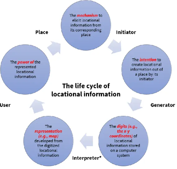
Specifically, there are five primary data actors in the location information lifecycle: Location, Initiator, Generator, Interpreter and User. This life cycle of location information also demonstrates the perception and practice loop in humans. If the site owner allows others to collect location information about the site, the site owner should receive incentives.
In 2015, the Office of the Mayor of London funded a database—the Combined Homelessness and Information Network (CHAIN)—to be administered by St. Here we offer 20 recommendations for the geospatial and location data communities to consider when engaging in any aspect of the location technology project lifecycle. Be aware of the teams you build and the panels you agree to be on.
In some cases, biases can be acknowledged in work communication, but more often, it is critical to take the time to recognize and uncover biases in the data and correct the biases if possible. These concerns need wider recognition by many stakeholders due to the increasing use of location information across applications and disciplines. Note-taking role - As a participant in a note-taking role, you will play a key role on days 1 and 2 of the summit to ensure that participants' opinions (including your own) are represented in the final outcomes of the summit .
Panelist Role - As a participant in a panelist role, you will play a key role on Day 1 or 2 of the Summit to promote and expand upon the initial thoughts shared by the Organizing Committee. As a panelist, you will be invited to join a panel that focuses on one of the 4 summit objectives. Moderator role - As a participant in a moderator role, you will play a key role on Days 2 and 3 of the Summit to promote and expand upon the initial thoughts shared on Day 1.
As a moderator, you will lead discussion groups that focus on one of the 4 summit objectives. The goal is for everyone to get on the same page about goals 1, 2 and 3 in the white paper, and to get the general mindset present in the room. The goal is to edit the initial perspectives each committee member worked on to incorporate the perspectives of the summit attendees.
We also want to initiate the final goal of the white paper (which calls for a more inclusive conversation).