The question of the location of the first landfall appears to have received little attention until the early nineteenth century. During our study of the Journal we were struck by a passage concerning Columbus's approach to the second island.
NO. 4 COLUMBUS S VOYAGE — LINK AND LINK 5 Pedroso upon our first meeting to read the original Spanish text for
COLUMBUS'S LANDFALL
We attempted to take Sea Diver to Grassy Creek Harbor to anchor, intending to launch a small boat and sail around the northern tip of the island, as Columbus might have done. There was an ideal location for an Indian village on the banks of the.
NO. 4 COLUMBUS S VOYAGE — LINK AND LINK 7 there was an ideal location for an Indian village on the banks of the
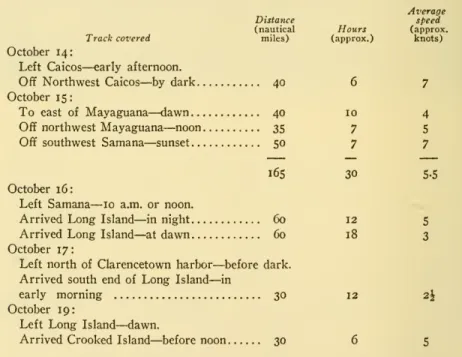
SEA DIVER TRACES COLUMBUS'S ROUTE
The Indians whom he had taken on board "made signs that they were very many, so that they could not be numbered, and they called more than a hundred of them by their names." They crossed into the ocean, while behind each of them was visible a lake of considerable size, which certainly in those early days must have been surrounded by 'the most beautiful grove of trees'. One was.
NO. 4 COLUMBUS S VOYAGE — LINK AND LINK 9
10 SMITHSONIAN MISCELLANEOUS COLLECTIONS VOL. I35 because of possible coral heads in the water between him and shore
Today he found little fresh water in the Ikihania Archipelago, and even in Columbus's time it must have been hard to find. Island, as Morison asserts, though it would be impossible for the same ships to sail in the same time from the southern tip of Acklin Island to the extreme northern point of Great Inagua, 87 miles away, at an average speed of 12 knots, as Verhoog suggests.
12 SMITHSONIAN MISCELLANEOUS COLLECTIONS VOL. 1 35 gazing at a faraway horizon or a coastline disappearing into the
How else to explain its deviation from the compass directions given by Columbus between Fernandina and. Isabella, and again when he left Isabella and made his way to Cuba by the Columbus coast, south of the Islas de Arena. Studying the map, one might wonder why he would choose a land apparently as small as Samana, when he could just as well have headed for Acklin as Verhoog suggests.
We have previously observed in our study of the maps that Acklin, while much larger in area than Samana, was low and flat on its northern part, while Samana had elevations of a hundred feet. It covered at least 45° of the horizon and, with the tops of its hundred-foot hills, looked like a great island.
14 SMITHSONIAN MISCELLANEOUS COLLECTIONS VOL, 1 35 pass any island without taking possession of it, although having taken
Columbus wrote: "I found a very beautiful harbor with a mouth, or rather with two mouths, for there is an islet in the middle and both mouths are very narrow, but inside it is more than wide enough for a hundred ships, if it is deep and clear and there is depth at the entrance." From there Columbus sailed northwest until he "discovered all that part of the island as far as the coast that runs east and west. The next morning, after a night of very heavy rain from after midnight till early morning, he found them at the south-east end of the island, where they anchored until the weather cleared.
At dawn on the morning of the 19th they set out to seek Samoet, the island that would yield the gold they sought. The 200-foot hill near the center of the island and the wide curved sweep of the beach from the tip south-southwest to a conspicuous cape in the distance, even the break that separated Crooked from Fortune Island with a small island in the middle, all with Columbus's description.
NO. 4 COLUMBUS S VOYAGE — LINK AND LINK I7
They continued west-southwest until 9 o'clock that night and made 5 miles, then changed course to west. 34;"There was shallow water everywhere for 5 or 6 leagues" is a perfect description of Columbus's banks south of the Ragged Islands. He verified that the topography matched in every respect Columbus' description and his approach from Crooked Island.
We anchored the Sea Diver off the small settlement of Cockburntown on the west coast of Watling Island, seeing a marker commemorating the first landing of Columbus(35). The present bird-dav rock with its lighthouse may be seen on the north-west part of Crooked Island," which was probably Columbus's Samoet Island.
NO. 4 COLUMBUS S VOYAGE — LINK AND LINK I9 half lakes and that the rocky headlands and sandy beaches of its
WATLING ISLAND NOT COLUMBUS'S SAN SALVADOR
20 SMITHSONIAN MISCELLANEOUS COLLECTIONS VOL, 1 35 4 hours before sighting San Salvador if he were approaching WatHng
Although it does not appear on the charts, we found Columbus's
34;maravilloso puerto," according to Morison, a few miles north of Burnt Earth on the northern part of LongIsland, a shallow hole separated from the sea by two narrow inlets and a rocky island. Thus it would have been impossible for Columbus to had "dis - covered the whole of the island as far as the coast running from east to west." Moreover, with rain and light winds, it is doubtful whether Columbus could have covered the distance from the most northwestern point of Long Island to the southern end from the twilight of a night for him.
From here we have no differences with the accepted theory that Columbus went on to Crooked Island and thence to Ragged.
COLUMBUS'S ROUTE TO CUBA NOT BY WAY OF MAYAGUANA, ACKLIN, AND GRAND INAGUA
On a course from Mayaguana to the point where Verhoog indi- cates that Columbus made contact with Acklin, the fleet would have
Either from the chart or seeing it from the air, one can imagine the break between Crooked and Acklin Islands as the "maravilloso puerto" that Columbus described 2 leagues from the cape. Columbus' fleet weighed anchor off the southern tip of Fernandina at dawn on Friday, October 19, to reach the island he later named Isabella. Before Columbus had sailed for 3 hours, he reported seeing an island to the east towards which they headed.
With her cruising speed of 8 knots we calculated that it would take us 11 hours to cover the 87 nautical miles between us and the northeast tip of Great Inagua. Our vantage point from the masthead did not see land until 03:12 that afternoon.
24 SMITHSONIAN MISCELLANEOUS COLLECTIONS VOL. I35 was a total of ii hours before we reached the cape, traveling at a
Verhoog then takes' Columbus to Southwest Point, which he selects as Cape de la Laguna "in order to steer northeast and east from
According to Verhoog, Columbus sailed over 200 miles from Great Inagua to reach Cuba when it would have been possible to take
Also on this course he would have been forced to sail through the dangerous reefs along the eastern edge of the Columbus Banks (44). There is no doubt that GreatInagua was Baneque, but because Verhoog had already assigned it as Isabella, he was not convinced. At this time the Journal records that Columbus "saw the island of Baneque due east," from which he was 60 miles distant.
Great Inagua is 34 miles from the Caicos Islands, while it is probably three times that distance from the Crooked Islands to either Caicos or Watling. That there is such a difference is not surprising, however, when one considers that Columbus could not see Isabella, or the Crooked Island archipelago, but only guessed its location from the death reckoning he made during the held intervening weeks while the ships sailed over foreign lands. and unprecedented waters.
26 SMITHSONIAN MISCELLANEOUS COLLECTIONS VOL. I35 have been only a guess, which happened to correspond with the
CONCLUSION
NOTES
NO. 4 COLUMBUS S VOYAGE — LINK AND LINK 27
Pedroso has the honor of being one of the few who have seen the remains of. Markham says that on the night of the nth the moon rose at 23.00, and at At 02.00 on the morning of the 12th it was 30° above the horizon. It would have shone brightly on the sandy shores of an island some miles ahead when it was in its third quarter.
34;The creeks dividing the islands, from Grand Caicos to South Caicos, are fordable, yet it is not so long that vessels of any size could reach the inner waters of the banks by passing between the islands." West Indies Pilot, vol.
NO. 4 COLUMBUS S VOYAGE — LINK AND LINK 29
30 SMITHSONIAN MISCELLANEOUS COLLECTIONS VOL, I35 His only use of isleta was in describing the "piece of land which is formed
BIBLIOGRAPHY
Un intento de resolver el problema del primer lugar de aterrizaje de autobuses de columna en el Nuevo Mundo. La lengua de Cristóbal Colón, el estilo de Santa Teresa y otros estudios sobre el siglo XVI.
32 SMITHSONIAN MISCELLANEOUS COLLECTIONS VOL. I35 Stewart, Glenn
ISLANDS
LBNK
APPENDIX
EXCERPTS FROM THE JOURNAL OF THE FIRST
VOYAGE OF COLUMBUS (OCTOBER 11 THROUGH OCTOBER 27, 1492) AS TRANSLATED FROM THE
The Admiral hoisted the royal standard, and the captains went with two ensigns of the green cross, which the Admiral carried on all ships as a flag. The admiral called the two captains and others who had gone down, and Rodrigo de Escobedo, notary of the whole fleet, and Rodrigo de Segovia, and bade them witness and testify how he, before all, was taking possession, as in fact he received from the said island in the name of the King and Queen, his sovereigns, making the declarations required, as is further contained. The following are the actual words of the admiral, in his book of the first voyage and discovery of these Indies.
Some of them are painted black, and they are the color of the people of the Canary Islands, neither black nor white, and some of them are painted white, and some red, and some in any color that they find. I saw no animal of any kind on this island, except parrots.” All these are the words of the admiral.
NO. 4 COLUMBUS S VOYAGE — LINK AND LINK 35
36 SMITHSONIAN MISCELLANEOUS COLLECTIONS VOL. I35 Sunday, October 14
NO. 4 COLUMBUS S VOYAGE — LINK AND LINK 37
When I was in the middle of the channel between these two islands, namely the island of Santa Maria and this large one which I call 'Fernandina,' I found a man alone in a boat going from the island of Santa Maria to the island of Fernandina. He also carried with him a basket of their making, in which he had a string of glass beads and two. Castilian pennies, from which I know that he came from the island of San Salvador and crossed over to the island of Santa Maria and was on his way to Fernandina.
I ordered him to come on board, as he wished to do so, and ordered his canoe to be brought on board also, and all that he had with him to be kept safe. 34;I left the island of Santa Maria de Concepcion, when it was already about noon, for that of Fernandina, which appeared very large towards the west, and sailed all that day in peace.
NO. 4 COLUMBUS S VOYAGE — LINK AND LINK 39
40 SMITHSONIAN MISCELLANEOUS COLLECTIONS VOL. 1 35
After that island, the coast runs to the west and extends for 12 leagues to a cape, which I called Cape Hermoso. From this part, on the north-east side, the coast forms a large neck of land and is very thickly wooded with very large trees. In the morning I want to go far inland until I find the village and see or speak to this king, who, according to the signs these people make, rules all the neighboring islands and is richly clothed and clothed. gold, although I don't believe much of what they say, both because I don't understand them well and because they are getting absorbed in everything.
After that I desire to travel to another very large island, which I think must be Cipango, according to the indications which the Indians I have give me; they call it 'Colba', in which they say there are ships and very many and magnificent sailors;. 34;Today I would like to sail to the island of Cuba, which I believe must be Cipango, according to the indications these people give me concerning.
44 SMITHSONIAN MISCELLANEOUS COLLECTIONS VOL. I35
NO. 4 COLUMBUS S VOYAGE — LINK AND LINK 45
NOTES TO APPENDIX