_________________________________________________________
School of Environment, The University of Auckland, Private Bag 92019, Auckland, New Zealand, p.kench@auckland.ac.nz
THE GEOMORPHOLOGY OF BAA (SOUTH MAALHOSMADULU) ATOLL AND ITS REEF ISLANDS
BY
PAUL S. KENCH
ABSTRACT
Historically there have been few detailed geomorphic studies of the reefs and reef islands of the Maldives archipelago. The earliest studies were largely descriptive and latter studies sparse and ad hoc. Over the past decade there has been a focussed research effort in Baa Atoll (also known as South Maalhosmadulu Atoll) aimed at improving understanding of the geomorphic characteristics, morphodynamics, evolution and
process controls on island formation and change. This paper synthesises this research and considers the broader significance for islands in the Maldives.
INTRODUCTION
Until recently there have been few detailed studies of the geomorphology of reefs and reef islands in the Maldives archipelago. Earliest scientific investigations of the Maldives involved hydrographic observations of the archipelago by Commander James Moresby 1835–1838. This work produced detailed hydrographic charts of the reef system, which remain the most accurate records of bathymetry in the archipelago.
The turn of the twentieth century saw the first expeditions to the Maldives to document the taxonomy and biogeography of reef biota and make observations of oceanographic conditions. Most notable were the expeditions of James Stanley Gardiner (1899–1900) who undertook the first descriptions of marine and terrestrial fauna and flora as well as observations of reef structure (Gardiner, 1903) and Alexander Agassiz (in 1901–1902) who undertook sampling and description of biological aspects of the reefs (Agassiz, 1903). Of note, Gardiner also made observations of some islands and reefal deposits including a selection from the reefs of southern Baa Atoll.
Between 1933 and 1934 Seymour Sewell led the “John Murray” expedition to the Maldives in which he undertook detailed geomorphic observations of a number of atolls and islands (Sewell, 1936a, b). The “Xarifa” expedition (1957-1958) undertook investigations of the sub-littoral ecology and structure of reefs in many atolls in the archipelago (Hass, 1965). This expedition was notable for its taxonomic investigation of faunal and floral communities, identification of high species diversity, and establishment of baseline monitoring locations for future reference of reef community dynamics (Wallace and Zahir, 2007). A British expedition also studied the marine and terrestrial geomorphology and ecology of Addu Atoll (Stoddart, 1966).
Based on these early observations Gardiner and Sewell speculated as to the origin, formation and process controls on island distribution (Gardiner, 1903; Sewell, 1936b).
For example, cemented rocks in the island of Maamaduvvari (Baa Atoll) were interpreted by Gardiner as evidence of a higher sea level. Furthermore, Sewell (1936b) undertook detailed observations of islands in Goidhoo Atoll and surmised that island distribution was related to exposure to the oceanic swell regime with islands absent along high energy windward margins of atolls.
Since these early expeditions the research effort in the Maldives has been limited and narrowly focused on specific aspects of reef ecology, geology, and management. As a result, large gaps exist in scientific knowledge and many atolls have not been visited by scientists since Gardiner and Sewell. However, over the past decade there has been a concerted effort to investigate aspects of reef and island geomorphology in Baa Atoll.
This paper summarises this work and examines the geomorphological characteristics of Baa Atoll and its reef islands. The focus of the paper is on the Holocene development of the atoll and its islands based on a synthesis of recent field investigations. Results are discussed in light of future trajectories of reef islands in Baa Atoll.
GEOLOGICAL SETTING
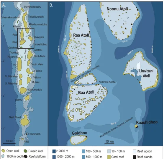
The Maldives archipelago comprises a chain of coral reefs and reef islands situated 700 km southwest of Sri Lanka (Fig. 1). The archipelago extends 868 km from Ihavandhippolhu in the north (6o57' N) to Addu Atoll (0o34' S) just south of the equator.
Comprising 2,041 reefs (Naseer and Hatcher, 2004) the archipelago is globally unique in biological diversity, the range reef structures it possesses and their mode of evolution.
The archipelago constitutes the central section of the Laccadives – Maldives – Chagos submarine ridge, which in turn is part of a larger feature that stretches from the early Tertiary Deccan Traps of India to the volcanically active zone of Reunion.
The Deccan Traps were the first manifestation of the stationary mantle hotspot that subsequently produced the volcanic ridge underlying the Maldives. Northward drift of the Indian Plate and northeastward motion of the African plate has resulted in northward age progression along this ridge (Duncan and Pyle, 1988; Duncan and Hargreaves 1990;
Tiwari et al., 2007).
The history of formation of the Maldivian atoll systems differs to the subsidence model proposed by Darwin (1842). The basement rocks underlying the Maldives are Eocene volcanics (55 million years old). These basement volcanics are capped by up to 3,000 m of limestones. Carbonate accumulation through the Tertiary was controlled by phases of aggradation and progradation modulated by large oscillations in sea level (Aubert and Droxler, 1992; Purdy and Bertram, 1993; Belopolsky and Droxler, 2003;
Kench, 2011). During the Quaternary the dominant mode of reef development has been vertical coral reef growth. This vertical reef growth is a consequence of high-amplitude sea-level fluctuations during the Pliocene-Pleistocene, producing alternate periods of exposure and submergence. During periods of submergence reefs accreted vertically to fill the accommodation space. The Holocene is the most recent of these reef growth phases.
3 Climatic Controls
The physical characteristics of atolls and reefs of the Maldives show marked latitudinal variations. Northern atolls are characterized by a heavily dissected atoll reef rim, numerous lagoonal patch reefs and faros and moderate lagoon depths (40-50 m).
Reef islands are located on the peripheral and lagoonal patch reefs of these northern atolls. In contrast, southern atolls are characterized by more continuous atoll reef rims, higher proportion of peripheral reef rim containing islands, few lagoonal patch reefs and deeper lagoons (70-80 m, Woodroffe, 1993).
Longitudinal variations in morphology have been attributed to broad north- south gradients in climate and oceanographic conditions. The archipelago is subject to monsoonal conditions that switch from the west to northeast in a predictable fashion. The intensity of oscillating monsoon conditions increases to the north. Incident wave energy and rainfall both reduce in magnitude and intensity toward the north. Spatial gradients in
Figure 1. Field setting of the Maldives archipelago and Baa atoll (A). Regional setting of Baa and neighbouring atolls (B).
boundary controls can influence rates of solutional lowering of lagoons during glacial and sediment transport and island formation processes on reef platforms. periods, and during highstands can control contemporary coral reef growth, sediment production
PHYSIOGRAPHIC CHARACTERISTICS OF BAA ATOLL Baa Atoll is located in the Northern Province and western side of the double chain of atolls that comprise the Maldives archipelago (Fig. 1). Baa is surrounded by a number of other atolls: Raa Atoll to the north, separated by the narrow Moresby Channel;
Noonu and Lhaviyani Atolls to the northeast and east, on the eastern side of the inner sea; and, the enclosed Goidhoo Atoll located approximately 20 km to the south (Fig.
1B). Collectively these neighbouring atolls afford a measure of protection to oceanic swell energy impacting Baa Atoll from the north to eastern sectors. To the southeast and also located on the eastern margin of the inner sea is the small reef platform island Kaashidhoo. However, the small size of this platform and distance from Baa suggest its influence on energy exposure is limited. Baa is exposed to ocean swell along its western and southwest margins.
The western reefs of Baa Atoll grade steeply to depths in excess of 1000 m. In contrast, on the eastern boundary the bathymetry of the shallow inner sea grades more gently to 500 m (Fig. 1B). Channels separating Baa Atoll from Raa in the north and Goidhoo in the south reach depths of 240 m and 560 m respectively.
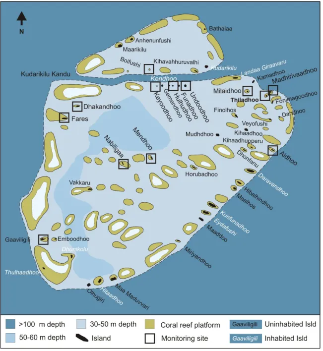
At the gross scale the structure of Baa Atoll can be divided into two sections; a large triangular-shaped rim of reef platforms in the south and a smaller triangular rim of reefs in the north separated by the narrow Kudarikilu Kandu (channel; Fig. 2). A network of individual reef platforms that extend 122 km and enclose a lagoon of 1,127 km2 defines the atoll periphery. The atoll is 38 km wide (on its longest west-east axis) and 46 km long along the southwest to northeast axis.
Baa Atoll contains 105 individual reef platforms with a total reef area of 263 km2. The size and location of the reef platforms varies markedly within the atoll. Forty-nine reefs occur on the atoll margin. The western rim of Baa comprises six large platforms that have a maximum length of 8.2 km and 4.2 km width. Most of these western reefs have internal lagoons. The remainder of the atoll periphery is characterised by smaller reef platforms typically less than 1 km in maximum length and 0.5 km in width (Fig. 2). There are 56 lagoon reefs, most of which are clustered in the southern and central sector of the lagoon. A number of lagoonal reefs also straddle either side of the Kudarikilu Channel in the north. Eleven of the lagoon reefs are faro.
There are a total of 33 major passages that connect the open ocean and lagoon around atoll rim. These passages range in width up to 4.2 km with a total passage length of 44.5 km. Consequently, the atoll structure can be categorised as ‘open’, with an effective aperture of 0.37. The bathymetry of Baa Atoll is characterised by passages that in general are 35-56 m in depth. One exception is the narrow Kudarikilu channel where depths reach 256 m. The depth of the majority of the lagoon ranges from 30–50 m. However, there is a slightly deeper sector that ranges from 50 m to 60 m located in southwestern and central section of the lagoon (Fig. 2).
5 There are 61 vegetated islands and at least four unvegetated sand cays located on the reef platforms of Baa Atoll. The spatial distribution, geomorphological and sedimentological characteristics of these islands are described in detail in this study.
Oceanographic Regime
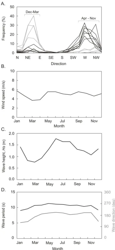
The climate of the Maldives can be divided into two monsoon periods marked by strong reversals in wind direction that are confined to a narrow range of wind angles.
Summary wind data since 1964 (Fig. 3A, B) indicate that the Maldives experience
Figure 2. Baa Atoll detailing the distribution of reefs and reef islands.
southwest to northwest winds (~ 225−315°) from April to November (westerly monsoon) with a mean wind speed of 5.0 ms-1. In contrast, winds from the northeast-east (~ 45-90°) prevail from November to March (northeast monsoon) with a mean wind speed of 4.8 ms-1 (Fig. 3A, B). Wind strength is most variable during the cross-over between northeast and westerly monsoons with mean wind speed falling to 3.5 ms-1 in March (Department of Meteorology, 1995).
Information on the deepwater wave climate is limited, but satellite altimetry wave climate data (for a ten-year period) for the region (Young 1999) indicates the dominant swell approaches from southerly directions (Fig. 3D). On a seasonal basis, swell is from the south-southwest from April to November with a peak significant wave height (Hs) of 1.8 m in June, and from the south to southeast directions from November to March with a minimum Hs of 0.75 m in March (Fig. 3C, D).
The broadscale oceanography of the atolls of the Maldives has been poorly studied.
Atoll-specific circulation and current patterns are controlled by the interaction of tide and wave processes with atoll structure. As noted above, the heavily dissected character of the Baa Atoll rim indicates the effective aperture of the atoll (proportion of gaps in the reef) is 37%. Consequently, the atoll is considered to be ‘open’ and allows penetration of tides and waves into the lagoon. The atoll is influenced by a microtidal regime with a spring tide range of approximately1.2 m.
At the atoll scale Kench et al. (2006) examined wave processes across Baa Atoll.
They showed that wave energy affecting the atoll varies between monsoon seasons and is spatially variable within the atoll in each monsoon. Wave energy impacting the atoll is considerably greater during the westerly monsoon. Furthermore, atoll structure promotes significant changes in wave energy and wave characteristics across the atoll.
Short period (3-8 s) monsoon-driven wave energy, which is significant on windward reefs, is dissipated on the peripheral reef network and the density of lagoonal patch reefs limits development of locally generated wind wave energy across the lagoon. However, longer period swell (8-20 s) propagates through the lagoon to leeward reefs. A windward to leeward decay in wave energy was evident in the westerly monsoon, but not in the northeast monsoon, when long period swell (from the southwest) remains significant on western reefs. Net energy calculations that account for seasonal changes in wave energy across the atoll identify a steep west-east gradient. In general, western reefs are dominated by westerly flowing energy that is 4.5-7 times the total energy input elsewhere in the atoll. Wave energy on central reefs is balanced whereas net energy on eastern reef platforms is dominated by eastward propagating energy. This steep energy gradient is likely to have geomorphic significance for reef growth and reef island development change throughout the atoll. As shown by Kench et al. (2006), for each individual reef platform incident wave energy is controlled by the relative presence or absence of boundary oceanic swell, the monsoonally forced wind-waves generated external and internal to the lagoon, as well as local sheltering factors promoted by proximity to other reefs.
7
Figure 3. Summary of Maldives wind and wave climate over a 10 year period. A) Percent frequency monthly wind direction. B) Mean wind speed. C) Significant wave height in region of Baa Atoll. D) Wave period and direction in region of Baa Atoll.
HOLOCENE REEF DEVELOPMENT
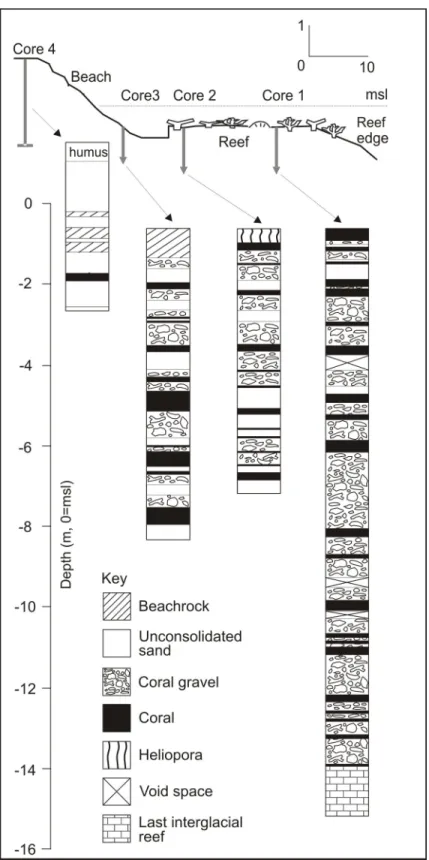
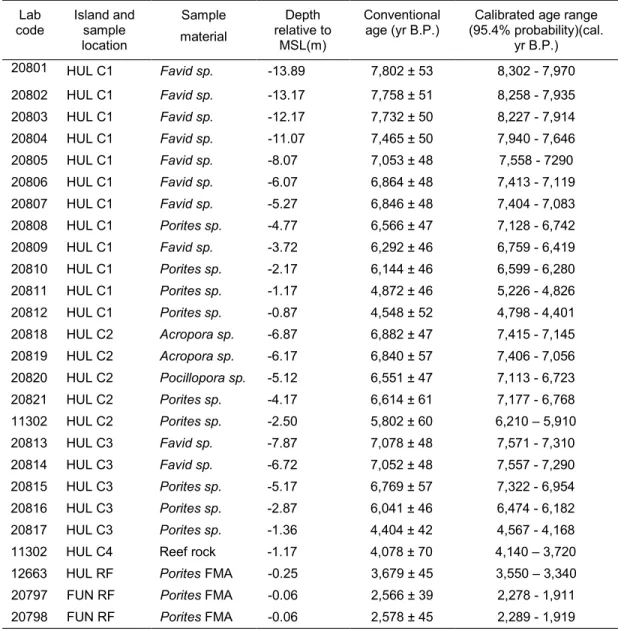
The contemporary surface morphology of the Maldivian reefs is the result of coral reef growth on Pleistocene foundations over the past 10,000 years. The Holocene reef growth history of the Maldives has only recently been resolved in detail based on drill cores from Ari and Baa Atolls (Gischler, 2008; Kench et al., 2009a). Of relevance to this discussion are three closely spaced rotary drill cores extracted from the Hulhudhoo reef flat in the central section of Baa Atoll lagoon. A summary of the drill cores from Hulhudhoo is presented in Figure 4 and radiometric dates on 23 coral samples from the cores are summarised in Table 1. The data provide insights into the Holocene development or reefs in Baa Atoll.
Reef Cores
The outer reef flat core penetrated 14.6 m through the outer reef surface and termi- nated in highly porous reef rock with recrystallisation and discoloration, characteristic of Last Interglacial reef limestone (Montaggioni, 2005; Woodroffe, 2005). Overlying this basal rock the core comprised alternating massive corals (predominantly poritids and fa- viids) and coral rubble (with encrusting coralline algae and little sand matrix).
The central and inner reef flat cores penetrated 6.2 m and 7.2 m below the reef surface respectively, terminating in Halimeda-rich sand (Fig. 4). Above these basal sedi- ments the cores comprised alternating layers of massive corals (poritids, acroporids and faviids), coral rubble and sand (Fig. 4A).A fourth core was extracted through the island ridge using a combination of hand auger and drill techniques (Kench et al., 2005). The is- land ridge core penetrated unconsolidated, medium-grained island sands in the upper 1.6 m before encountering multiple layers of cemented sand (beach rock or cay sandstone).
Underlying the island sediments in situ coral and reefal sediments were encountered.
Kench et al. (2009a) noted a number of conspicuous features of the massive corals in cores. First, favid and acroporid species dominate below a depth of 5 m. Second, porit- id corals dominate the core above 5 m as well as on the contemporary reef flat. Third, the growth structure and orientation of corallites within the massive corals are indicative of in situ growth position and the thickness of the fossil corals in cores (typically 0.2 to 0.4 m) was comparable to that of living microatolls on reef flats surrounding the study islands.
Radiometric Ages of Core Material and Reef Growth
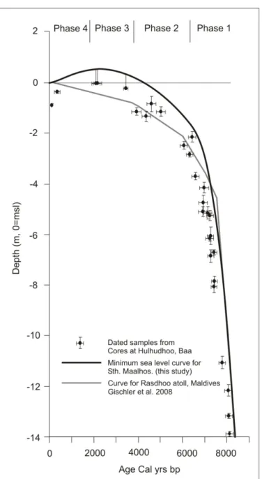
Uranium-series dating of the basal reef sample in core 1 yielded a minimum age of 122,000 ± 7.0 ka (at -14.12 below msl) confirming this limestone as Last Interglacial reef. Results of dating coral material above the interglacial surface provide the timing of reef establishment and chronology of reef growth in the Holocene. An age of ca 8,100 cal yBP (Table 1), immediately overlying the Last Interglacial surface records the initia- tion of the Holocene reef growth on Hulhudhoo. This age for Holocene reef initiation is comparable to that from Rasdhoo Atoll (Gischler et al., 2008) and other oceanic reefs in the western Indian Ocean (Montaggioni, 2005). Further dates indicate steady vertical reef growth followed from ca 8,100 to 6,400 cal yBP (to a water depth of -2.17 m below msl)
9
Figure 4. Reef drill cores on southern Hulhudhoo reef flat, Baa Atoll, Maldives. Topography of island margin and reef flat shown at top. After Kench et al., 2009a.
at a mean rate of ~7 mm/y. The rate of vertical reef accretion then slowed to ~ 0.8 mm/y ca 6,400 cal yBP, the reef first reaching near its present level approximately 4,000-4,500 yr ago. Ages of the uppermost poritids from cores 1 and 2 and of in situ fossil Heliopora in core 4 have an age range from ca 3,900 to 4,600 cal yBP suggesting the Hulhudhoo reef reached its maximum width at this time.
Comparison of the age and elevation of dated corals between cores indicates that:
reef development was dominated by vertical growth from ca 8,000 to 6,500 cal yBP with no evidence of lateral extension of the fore reef to seaward. Subsequently, the outer sec- tion of reef accreted at a faster rate than the inner reef between ca 6,500 and 4,500 yr ago (Table 1).
Table 1. Radiometric ages from reef cores and microatolls on Hulhudhoo and Funadhoo Islands, Baa atoll.
code Lab Island and sample location
Sample material
Depth relative to
MSL(m)
Conventional
age (yr B.P.) Calibrated age range (95.4% probability)(cal.
yr B.P.) 20801 HUL C1 Favid sp. -13.89 7,802 ± 53 8,302 - 7,970 20802 HUL C1 Favid sp. -13.17 7,758 ± 51 8,258 - 7,935 20803 HUL C1 Favid sp. -12.17 7,732 ± 50 8,227 - 7,914 20804 HUL C1 Favid sp. -11.07 7,465 ± 50 7,940 - 7,646 20805 HUL C1 Favid sp. -8.07 7,053 ± 48 7,558 - 7290 20806 HUL C1 Favid sp. -6.07 6,864 ± 48 7,413 - 7,119 20807 HUL C1 Favid sp. -5.27 6,846 ± 48 7,404 - 7,083 20808 HUL C1 Porites sp. -4.77 6,566 ± 47 7,128 - 6,742 20809 HUL C1 Favid sp. -3.72 6,292 ± 46 6,759 - 6,419 20810 HUL C1 Porites sp. -2.17 6,144 ± 46 6,599 - 6,280 20811 HUL C1 Porites sp. -1.17 4,872 ± 46 5,226 - 4,826 20812 HUL C1 Porites sp. -0.87 4,548 ± 52 4,798 - 4,401 20818 HUL C2 Acropora sp. -6.87 6,882 ± 47 7,415 - 7,145 20819 HUL C2 Acropora sp. -6.17 6,840 ± 57 7,406 - 7,056 20820 HUL C2 Pocillopora sp. -5.12 6,551 ± 47 7,113 - 6,723 20821 HUL C2 Porites sp. -4.17 6,614 ± 61 7,177 - 6,768 11302 HUL C2 Porites sp. -2.50 5,802 ± 60 6,210 – 5,910 20813 HUL C3 Favid sp. -7.87 7,078 ± 48 7,571 - 7,310 20814 HUL C3 Favid sp. -6.72 7,052 ± 48 7,557 - 7,290 20815 HUL C3 Porites sp. -5.17 6,769 ± 57 7,322 - 6,954 20816 HUL C3 Porites sp. -2.87 6,041 ± 46 6,474 - 6,182 20817 HUL C3 Porites sp. -1.36 4,404 ± 42 4,567 - 4,168 11302 HUL C4 Reef rock -1.17 4,078 ± 70 4,140 – 3,720 12663 HUL RF Porites FMA -0.25 3,679 ± 45 3,550 – 3,340 20797 FUN RF Porites FMA -0.06 2,566 ± 39 2,278 - 1,911 20798 FUN RF Porites FMA -0.06 2,578 ± 45 2,289 - 1,919 Note: Radiocarbon dates obtained from the Radiocarbon Dating Laboratory, University of Waikato, New Zealand. Ages calibrated by using OxCal version 3.5 (Bronk Ramsey, 2001) with the marine data set (Stuiver et al., 1998) and Delta-R value of 132 ± 25 as best estimate for the central Indian Ocean reservoir effect (Southon et al., 2002). FMA = fossil microatoll, HUL = Hulhudhoo, FUN = Funadhoo. From Kench et al. 2009a.
11 Emergent Reef Flat Corals
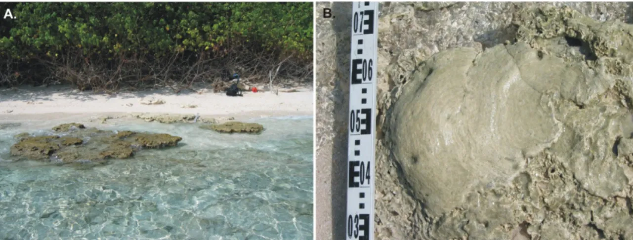
In addition to reef cores a number of radiometric dates were obtained from emergent fossil microatolls on Hulhudhoo and the neighbouring island Funadhoo (Fig.
2, 5). On Hulhudhoo, a sample from one Porites microatoll dated at ca 3,400 cal yBP is situated 0.25 ± 0.07 m below msl, which is 0.18 ± 0.05 m above the upper limit of present living microatolls. Samples from two Porites microatolls dated at ca 2,100 cal yBP from Funadhoo were up to 0.37 ± 0.06 m above the upper limit of contemporary coral growth (0.06 m ± 0.06 m below msl; Table 1). These microatolls outcrop at the island shoreline and overlie in situ fossil Heliopora (Fig. 5).
Seasonal movements of beach sands and coral rubble have abraded the upper surfaces of these fossil microatolls (Fig. 5). Thus the surveyed elevations represent minimum palaeo-sea level positions. Observations of the mean thickness of living microatolls throughout the atoll suggest that as much as 0.15-0.2 m has been removed by abrasion. It is conservatively estimated that coral growth occurred to at least 0.5 ± 0.1 m above present around 2,100 yBP. The presence of emergent fossil microatolls has profound implications for understanding sea level change.
Sea Level History
The presence of massive living poritid and faviid corals, including microatolls, on the contemporary reef flats of Baa Atoll, together with the frequent occurrence of their fossil equivalents throughout the Hulhudhoo cores is indicative of a comparable palaeo-reef setting, suggesting that accretion of the Hulhudhoo reef closely tracked rising sea level.
The presence of emergent fossil in situ microatolls provides a higher resolution late- Holocene sea-level indicator as their upper growth surface is constrained by subaerial exposure during low tides (Smithers and Woodroffe, 2000).
Based on these interpretations the Holocene sea level history in Baa Atoll can be inferred. The sea level record is divided into four distinct phases (Fig. 6). Phase 1 is characterised by a steady sea-level rise of ~ 7 mm/y, which flooded the last interglacial
Figure 5. Photograph of Heliopora reef capped by fossil microatolls outcropping on eastern shoreline of Funadhoo (A). Photograph taken two hours prior to high tide. B) Abraded fossil microatoll in growth position above fossil Heliopora surface.
surface around 8,100 to 6,500 cal yBP. Phase 2 spanned the period 6,500 to 4,500 cal yBP and is characterised by decrease in the rate of sea-level rise to <1 mm/y. Sea level first reached present level at around 4,500 cal yBP. During Phase 3 sea level continued to rise to at least 0.5± 0.1 m above present until ca 2,100 cal yBP. The fourth and final phase is the subsequent falling of sea level from the late-Holocene highstand to its current elevation.
These results clarify the pattern of Holocene sea level change in Baa Atoll which is of relevance to the entire Maldives archipelago. Of note, the mid-Holocene reef growth
Figure 6. Age-depth plot of reef core and fossil microatoll samples. Inferred minimum sea level history represented by black line. Horizontal bars represent 2σ calibrated age range (Table 1) and vertical bars are defined by uncertainties of coral elevation. After Kench et al., 2009a.
13 history is comparable to that described by Gischler et al. (2008) on Rasdhoo Atoll, although no evidence for a higher sea level was found at that location. The elevated microatolls on Baa provide unequivocal evidence of a late-Holocene sea level highstand ca 2,000-4,000 yr ago. At a regional scale these results are significant as they confirm that emergent reef build-ups are not missing from the central Indian Ocean as suggested by Camoin et al. (2004).
REEF ISLANDS OF BAA ATOLL
Baa Atoll contains 61 vegetated reef islands which are located on peripheral and lagoonal reef surfaces. In addition there are at least four unvegetated and ephemeral unvegetated sand cays. The vegetated islands and unvegetated sand cays in Baa are diverse in their morphological and sedimentary characteristics. As identified earlier physical descriptions of some of the islands in the southern part of the atoll were undertaken by Gardiner (1903) and provide a basis to examine island change.
Over the past decade there has been an increased research effort to better understand the geomorphic characteristics of islands in Baa Atoll, their evolution and morphodynamics (Ali, 2000; Kench and Brander, 2006; Kench et al., 2005; Kench et al., 2006; 2008). In particular, 13 islands throughout Baa Atoll were identified and established as the first sites of geomorphic monitoring in the Maldives (Fig. 2). These islands have been the focus of repetitive geomorphic surveys and mapping since 2002.
Monitoring observations have been used to examine seasonal variations in island
shorelines (Kench and Brander, 2006) and assess the impacts of the Indian Ocean tsunami on islands (Kench et al. 2006, 2007, 2008; Nichol and Kench 2008).
Physical Characteristics of Islands
The islands of Baa Atoll are found both on the peripheral reef rim (n=34) and internal lagoon reefs (n=31). A number of observations can be made with regard to the physical distribution of islands. First, there are only three islands located on the western exposed rim of the atoll and these are all small in size. Second, the highest density of islands occurs on the southern to eastern peripheral rim of the atoll. Third, exploration of descriptive characteristics between lagoonal and peripheral islands identified few meaningful differences. However, average island area is greater on peripheral islands (10.9 ha) compared to lagoonal islands (7.6 ha; Table 2).
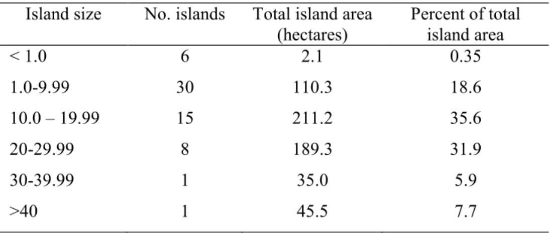
Physical dimensions of islands are summarised in Table 3. Island size ranges from less than 1 hectare to more than 45 hectares. Over half of all islands (38) are less than 10 hectares in area and collectively account for 19% of total land area in the atoll. Islands between 10 and 30 hectares in area (23 in total) account for 67.5% of atoll land area. Of note, only two islands are larger than 30 hectares. Dharavandhoo is the largest island in the atoll at 45.5 ha in area. This elongate island is 1.32 km in length and 480 m in width.
The second largest island Kunfunadhoo is 35 hectares in area. Collectively these two
islands account for 13% of total land area in the atoll. Islands occupy varying proportions of their reef platforms ranging from less than 1% to a maximum of 71% on Olhugiri (x=23%). Islands are also found in a broad spectrum of planimetric shapes from linear to near circular. In general, island shape mirrors reef platform shape except where there are multiple islands on reefs or where the island is extremely small compared with reef area.
Geomorphic Characteristics of Islands
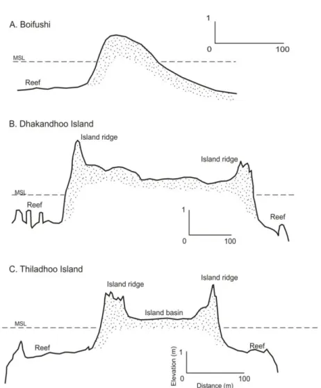
Surveys depicting the morphology of islands have been undertaken on 43 of the islands in Baa Atoll (Ali, 2000; Kench and Brander, 2006). Typical island cross-sections are presented in Figure 7 and can be divided into 3 characteristic morphologies. 1) Convex islands with simple convex ridges (Fig. 7A). Unvegetated sand cays or small vegetated islands which can experience washover under higher water level conditions typically exhibit this morphology. 2) Asymmetric islands with a high seaward ridge which slopes lagoonward. The island surface typically terminates in a more subdued ridge on the opposite side of the island (Fig. 7B). 3) Basin shape islands where high marginal ridges impound a lower elevation central depression (Fig. 7C). This is the most common island morphology and is typical of the medium to larger islands in the atoll.
There is significant variation in the elevation of island ridges. Ali (2000) reported a maximum ridge elevation on Funadhoo of 3.19 m above mean sea level (msl). Kench et al. (2008) show marked changes in ridge elevation both within islands and across the atoll that are related to energy exposure. In general, highest ridge elevations occur where shorelines are exposed to higher wave energy. Examining islands across a west to east transect Kench et al. (2008) found consistent variations in island ridge elevation within islands, with western exposed island ridges typically 0.5-1.2 m higher than leeward island ridges. Furthermore, they showed that the eastern island Thiladhoo had much lower elevation ridges (1.08 – 1.59 m) than western and central islands (1.44-2.51 m range). Kench et al. (2008) suggest the dominant westerly monsoon wave conditions are responsible for such spatial patterns with higher wave energy promoting greater swash excursion on island shorelines and greater run-up deposition.
Table 2. Summary of vegetated island size classes in Baa atoll.
Island size No. islands Total island area
(hectares) Percent of total island area
< 1.0 6 2.1 0.35
1.0-9.99 30 110.3 18.6
10.0 – 19.99 15 211.2 35.6
20-29.99 8 189.3 31.9
30-39.99 1 35.0 5.9
>40 1 45.5 7.7
15
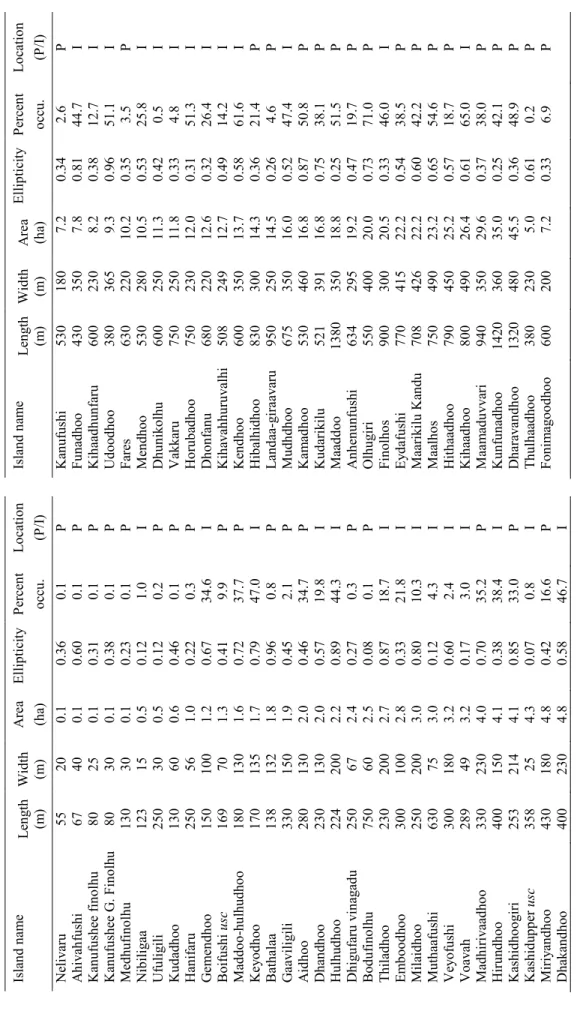
Island name Length (m)Width (m)Area (ha)EllipticityPercent occu. Location (P/I)Island name Length (m)Width (m)Area (ha)EllipticityPercent occu. Location (P/I) Nelivaru55200.10.360.1P Kanufushi5301807.20.342.6P Ahivahfushi 67400.10.600.1P Funadhoo 4303507.80.8144.7I Kanufushee finolhu 80250.10.310.1P Kihaadhunfaru 6002308.20.3812.7I Kanufushee G. Finolhu80300.10.380.1P Udoodhoo3803659.30.9651.1 I Medhufinolhu130300.10.230.1P Fares63022010.2 0.353.5P Nibiligaa123150.50.121.0I Mendhoo53028010.5 0.5325.8 I Ufuligili 250300.50.120.2P Dhunikolhu 60025011.3 0.420.5I Kudadhoo130600.60.460.1P Vakkaru75025011.8 0.334.8I Hanifaru250561.00.220.3P Horubadhoo75023012.0 0.3151.3 I Gemendhoo1501001.20.6734.6 I Dhonfanu68022012.6 0.3226.4 I Boifushi usc169701.30.419.9P Kihavahhuruvalhi50824912.70.4914.2 I Maddoo-hulhudhoo1801301.60.7237.7P Kendhoo60035013.70.5861.6 I Keyodhoo 1701351.70.7947.0I Hibalhidhoo 83030014.3 0.3621.4 P Bathalaa1381321.80.960.8P Landaa-giraavaru95025014.5 0.264.6P Gaaviligili3301501.90.452.1P Mudhdhoo67535016.0 0.5247.4I Aidhoo2801302.00.4634.7P Kamadhoo53046016.8 0.8750.8 P Dhandhoo2301302.00.5719.8 I Kudarikilu52139116.8 0.7538.1 P Hulhudhoo 2242002.20.8944.3 I Maaddoo 1380 35018.8 0.2551.5 P Dhigufaru vinagadu 250672.40.270.3P Anhenunfushi63429519.2 0.4719.7P Bodufinolhu 750602.50.080.1P Olhugiri55040020.0 0.7371.0P Thiladhoo 2302002.70.8718.7I Finolhos90030020.5 0.3346.0 I Emboodhoo3001002.80.3321.8 I Eydafushi 77041522.2 0.5438.5 P Milaidhoo 2502003.00.8010.3 I Maarikilu Kandu 70842622.2 0.6042.2 P Muthaafushi630753.00.124.3I Maalhos 75049023.2 0.6554.6 P Veyofushi3001803.20.602.4I Hithaadhoo79045025.2 0.5718.7P Voavah289493.20.173.0I Kihaadhoo 80049026.4 0.6165.0 I Madhirivaadhoo3302304.00.7035.2 P Maamaduvvari 94035029.6 0.3738.0 P Hirundhoo 4001504.10.3838.4 I Kunfunadhoo 1420 36035.0 0.2542.1 P Kashidhoogiri2532144.10.8533.0 P Dharavandhoo1320 48045.5 0.3648.9 P Kashidupper usc358254.30.070.8I Thulhaadhoo3802305.00.610.2P Miriyandhoo4301804.80.4216.6 P Fonimagoodhoo6002007.20.336.9P Dhakandhoo 4002304.80.5846.7I NB: Percent Occu. = percentage of reef platform occupied by island; P= peripheral reef, I=internal reef; usc = unvegetated sand cay
Table 3. Physical characteristics of islands in Baa atoll.
While island ridges are relatively high, the central island depression is substantially lower in elevation -typically less than 1.0 m above msl. While island morphologies can be reduced to three simple forms the surface morphology of islands exhibit complex morphologies at the island scale. For example, island surfaces can exhibit multiple ridge sequences. Furthermore, on some islands additional depressions exist that are occupied by mangrove (faa) or freshwater ponds (kulhi). At least three islands are known to have kulhi or faa (Dhakandhoo, Hirundhoo and Maamaduvvari). The presence of enclosed kulhi and faa signifies that small lagoons may have been closed through alongshore extension of island ridges during island development. Indeed, such a sequence of events has taken place on Maamaduvvari which was initially described by Gardiner (1903) as having a small lagoon but which has subsequently been occluded with the formation of a barrier across the northwestern section of the island.
Unconsolidated Island Sediments
The reef islands of Baa Atoll are composed entirely of calcareous sediments derived from the skeletal remains of reefal organisms. However, the texture, composition of sediments and degree of lithification of island sediments do differ between islands.
Figure 7. Characteristics morphologies of reef islands in Baa atoll. A) Convex morphology; B) Asymmetric ridge morphology; C) Basin morphology.
17 Gravel Deposits. On wave exposed sectors of the atoll periphery, islands are
composed of coarse coral rubble. For example, on Ahivahfushi (northwest), Gaaviligili (southwest) and Aidhoo (northeast) the ocean shoreline consists of a sequence of gravel ridges that represent phases of island accumulation (Fig. 8A, B). Gravel deposits have also been identified on Ufulgili, Olhugiri and Maamaduvvari. The gravels are composed almost entirely of coral clasts. However, the lagoon ends of islands appear to be composed of sand-size material forming spits that extend lagoonward across the reef platforms.
Sand Deposits. The majority of leeward peripheral islands and all lagoon islands are composed of sand-size calcareous sediments (Fig. 8C, D). An analysis of more than 107 beach samples from 10 islands in Baa Atoll indicated that sediment size ranged from 0.7 to 2.0 phi (0.6 mm to 0.25 mm) although the mean size was approximately 1.4 phi (0.38 mm, Cameron, 2002). Ali (2000) reported a similar size range for island sediments of Baa Atoll. Sand islands consist of a vegetated island core, which is surrounded by an unvegetated and mobile beach.
The composition of 13 island sediment samples, from 9 islands, was examined by Ali (2000) (Table 4). Results indicate that sediment composition is dominated by coral (20-66%). Halimeda (up to 47%) and molluscan fragments are of secondary importance in deposits with foraminifera and other components comprising subordinate fractions (<10%). However, the number of samples analysed were too few to provide a robust assessment of the sediment composition or spatial differences in constituents contributing to islands. Such differences can occur within islands and are discussed later.
Table 4. Summary of the skeletal composition of 13 island samples from Baa Atoll.
Island Depth
(m) Coral Mollusc Halim. Foram Alcyon. Crust/Echin Coralline algae Unkn
Aidhoo 0.75 62.7 18.1 2.2 5.0 5.3 3.3 0.0 3.3
Aidhoo 1.20 40.7 25.0 11.6 7.5 6.4 5.4 0.0 3.4
Bodufinolhu 1.25 38.1 17.9 26.8 6.5 4.6 3.3 0.7 2.2
Fares 2.0 48.4 13.4 20.6 8.4 2.3 3.1 0.2 3.7
Hanifaru 0.98 52.2 7.9 21.7 7.6 1.8 5.3 0.7 2.8
M-Hulhudhoo 0.8 59.6 12.6 0.0 16.5 4.0 1.3 0.0 6.0
M-Hulhudhoo Beach 53.6 23.6 1.4 5.2 7.2 3.5 0.6 4.9
Mendhoo 1.6 48.2 15.9 6.9 7.2 10.5 7.2 1.1 3.0
Nelivaru 2.95 44.7 17.5 17.3 11.9 0.8 3.6 0.4 3.8
Olhugiri 1.20 66.1 13.6 0.0 6.1 6.1 5.2 0.0 2.9
Olhugiri 1.8 42.8 23.6 18.3 9.5 1.3 2.2 0.7 1.6
Udoodhoo 1.15 20.6 8.3 47.4 9.3 7.5 3.0 0.0 4.0
Udoodhoo Beach 55.8 12.5 1.3 10.3 8.8 4.7 3.5 3.1
Depth = depth below island surface; Halim. = Halimeda; Foram. = foraminifera; Alcyon. = Alcyonarian spicules; Crust/Echin. = Crustacean and Echinoids; Unkn. = unknown. Source (Ali, 2000).
Mobile Beaches. Beaches composed of sand-size material are very dynamic, with shorelines shifting position markedly at seasonal timescales. Seasonal monitoring of beach position using Global Positioning System (GPS) surveys was instigated on 13 islands in Baa Atoll in 2002 and provides a useful baseline to assess ongoing geomorphic changes in islands (Kench and Brander, 2006).Figure 9 shows summary GPS surveys documenting the position of beaches on selected islands between monsoon seasons.
The data show large changes in beach position between monsoon periods. However, the net change in beach position was minimal on an annual basis (Kench and Brander, 2006). Furthermore, the degree of shoreline change appears to vary between islands of differing shape. For example, circular islands (e.g. Hulhudhoo) display larger changes in beach position around the island shoreline, whereas the elongate islands display more constrained shoreline change, principally around the apexes of islands. Based on detailed hydrodynamic investigations it has been established that observed beach change is driven by monsoonally-forced oscillations in wave and current processes (Kench et al., 2009b, c).
Figure 8. Examples of unconsolidated sedimentary materials comprising islands in Baa atoll. Gravel ridges on Gaaviligili (A) and Aidhoo (B); sand spit on Aidhoo (C) and typical beach on Milaidhoo (D) Location of islands shown in Figure 2.
19
Seasonal beach change is geomorphically important. It is responsible for large volumetric fluxes of sediment around island shorelines on a seasonal basis; it regulates the transfer of sediments between the reef and vegetated core of the island surface (Kench 2008), and it occupies the inner reef flat surface and prevents coral growth. Indeed the footprint of beach demarcates the boundary of the inner reef platform moat. Beyond the moat upward reef growth has continued until confined by sea level, with the living reef edge elevated up to 1.0 m above the moat surface.
Lithified Island Sediments
A range of lithified sediments are found on the islands of Baa Atoll (Fig. 10).
They are found in distinct geomorphic zones, have different modes of formation and occupy different elevations with respect to sea level. The lithified sediments can in some cases be extensive and can assist in the stabilisation of islands and their shorelines.
Figure 9. Seasonal beach change around selected islands in Baa Atoll. Selected islands are part of a monitoring network in the atoll. Location of islands shown in Figure 2.
Beachrock is prevalent on many islands in the atoll. (Fig. 10A). Distinctive in its intertidal elevation and in the slope that mirrors the contemporary beach, on some islands beachrock forms near continuous deposits that encircle islands (e.g, Keyodhoo, Hulhudhoo, and Udoodhoo). In these islands beachrock is seasonally buried by the movement of the contemporary beach. Beachrock is also found detached from island shorelines where it documents previous island positions on the reef platform.
Conglomerate. Lithified deposits of gravel and sand occur on the high energy shores of a number of peripheral islands (Fig. 10B). Such deposits do not possess the sloping surface characteristic of beachrock and are interpreted as cemented high energy deposits or even cemented gravel ridges that have subsequently been eroded. Examples can be found on Aidhoo and Gaaviligili. Gardiner (1903) also described this deposit on Maamaduvvari although at the time he interpreted this rock as evidence for higher sea level.
Cay sandstone can form at the level of the water table beneath islands. Cay sandstone consists of cemented bioclastic sand-size sediments and is distinguished from beachrock by near horizontal bedding. In Baa Atoll cay sandstone is not found on all islands but where it is present can be more than 1 m thick (Fig. 10C).
Figure 10. Examples of consolidated sediments on islands of Baa Atoll. A) Continuous beachrock sur- rounding the Keyodhoo Island shoreline. B) Conglomerate rock that outcrops on island shorelines. C) Cay sandstone outcropping on island shoreline and typical of massive rock located beneath the island surface in some islands. D) Phosphate rock outcropping on the Keyodhoo shoreline. Note brown colouration of rock.
Phosphate rock is found beneath the island surface on a number of islands in Baa Atoll.
21 Phosphate rock can occur and forms at the water table and within the soil horizons of islands in Baa Atoll. Phosphate rock also comprises cemented reefal bioclastic
sediments; however, the grains are replaced by phosphate minerals (Hopley, 2011).
Phosphate rocks in Baa Atoll are distinguished by their light orange to brown colouration (Fig. 10D). Island cores extracted from a range of islands indicate that phosphate rock is not ubiquitous. However, where phosphate rock occurs it can form continuous cemented layers that underlie the island surface. For example, on Dhakandhoo and Thiladhoo islands on the west and eastern sides of the atoll phosphate rock is found as a continuous layer beneath the island. On Keyodhoo and some other islands, erosion of the shoreline has exposed phosphate rocks which outcrop at the shoreline. Investigations from
Dhakandhoo show that the phosphate layer has been mined by local communities for the purposes of agricultural fertilisation.
Island Evolution
The detailed evolution of reef islands in Baa Atoll has been investigated by Kench et al. (2005) based on detailed coring and radiometric dating of island sediments. A summary of the radiometric dates and chronostratigraphy of three islands is presented in Figure 11 and Table 5. The data show that island sediments are of mid-Holocene age. Chronostratigraphic analysis of the dated sediments relative to the underlying reef provides insights into the temporal development of the islands in Baa Atoll. A three- phase model of island formation has been proposed (Kench et al., 2005). First, the small reef platform islands appear to have been deposited over infilled faro lagoons (velu).
As reef growth approached sea level they encountered wave base, which provided a process mechanism to flush reefal sediments into lagoons. Radiometric ages of suggest velu sediments were deposited approximately 5,500 to 5,000 yBP. Second, island accumulation across velu deposits was initiated approximately 5,000 yBP. The narrow range of ages of island sediments (5,125 ± 61 to 3,736 ± 57 yBP), particularly on
Dhakandhoo and Hulhudhoo indicate that islands accumulated rapidly with deposition of the vegetated core of islands effectively complete by 4,000 yBP. The third phase spans the past 4,000 years and is characterised by cessation of island building. Lithification of sediments as cay sandstones, phosphate rocks and beachrock has assisted in the stabilisation of islands. Further dates on reefal materials (Tables 1 and 5) show that continued vertical reef growth occurred over the past 4,000 years which would have progressively closed down the process window from that under which islands were constructed. The interaction between vertical reef growth on the outer reef and seasonal oscillations in beach position, which constrained vertical reef development on the inner reef, is responsible for development of nearshore moat that surrounds reef islands.
Figure 11. Morphostratigraphy of reef and island cross sections, Baa Atoll. Location of islands shown on Figure 2. A) Dhakandhoo B) Hulhudhoo C) Thiladhoo. Conventional radiocarbon ages shown in red are in correct stratigraphic position (see Table 5 for error terms).
23
Island Laboratory
code
Facies designation and material
Depth relative to MSL(m)
Conventional age (yr B.P.)
Calibrated age range (95.4% probability)
(cal. yr B.P.)
Dhakandhoo Wk 11293 Velu facies: sand –0.29 5139 ± 62 5550–5200
Wk 11294 Velu facies: sand –2.55 5362 ± 63 5730–5440
Wk 11295 Velu facies: sand –1.58 5032 ± 60 5410–5000
Wk 11296 Finolhu facies: sand –1.23 5125 ± 61 5530–5130
Wk 11297 Finolhu facies: sand 0.05 4905 ± 51 5230–4860
Wk 12661 Finolhu facies: sand –0.05 4512 ± 42 4680–4440
Wk 12662 Finolhu facies: sand –1.18 4352 ± 44 4880–4250
Wk 12660 Dead in situ coral –0.92 105 ± 0.5 Modern
Hulhudhoo Wk 12097 Finolhu facies: sand 0.26 4335 ± 46 4460–4210
Wk 11298 Finolhu facies: sand –0.29 4234 ± 52 4320–3970
Wk 11299 Finolhu facies: sand –0.34 4832 ± 59 5140–4790
Wk 11300 Velu facies: sand –1.29 5168 ± 62 5560–5260
Wk 11301 Finolhu facies: sand –0.51 3736 ± 57 3640–3350
Wk 11302 In situ reef rock –1.17 4078 ± 70 4140–3720
Wk 11303 Reefal sand –1.80 1259 ± 47 780–570
Wk 11304 In situ coral –2.50 5802 ± 60 6210–5910
Wk 12663 In situ fossil Porites –0.26 3679 ± 40 3550–3340 Wk 12664 Finolhu facies: sand –0.145 3970 ± 40 3950–3720
Wk 12665 Island-margin sand –1.13 3954 ± 40 3930–3700
Thiladhoo Wk 11305 Finolhu facies: sand –0.79 2677 ± 57 2340–2050
Wk 11306 Velu facies: sand –1.84 3000 ± 55 2750–2430
Wk 11307 Island-margin sand 0.40 2795 ± 54 2540–2160
Wk 11308 Velu facies: sand –1.52 5402 ± 54 5750–5480
Wk 11309 Beachrock 0.18 1064 ± 45 630–460
Wk 11310 Beachrock 0.00 1569 ± 44 1100–890
Wk 11311 In situ fossil Porites –1.09 952 ± 46 530–330
Wk 12666 Velu facies: sand –1.52 5336 ± 43 5680–5460
Wk 12667 Island-margin sand –0.14 1518 ± 37 1030–840
Wk 12668 Island-margin: sand –0.39 1587 ± 36 1100–920
Note: Radiocarbon dates obtained from the Radiocarbon Dating Laboratory, University of Waikato, New Zealand. Ages calibrated by using OxCal version 3.5 (Bronk Ramsey, 2001) with the marine data set (Stuiver et al., 1998) and Delta-R value of 132 ± 25 as best estimate for the central Indian Ocean reservoir effect (Southon et al., 2002).From Kench et al., (2005).
Table 5. Radiocarbon dates from detailed morphostratigraphic studies of three islands in Baa Atoll, Maldives.
It is evident that a major phase of island formation occurred in Baa Atoll between 5,000 and 4,000 yBP. Additional near surface radiocarbon dates from a number of other islands are consistent with this interpretation (Table 6). Comparison of the chronology of island formation with the established sea level curve in Baa Atoll provides further insights into the relationship between sea level, island formation and island persistence in the Holocene. First, evidence from the reef growth record (Fig. 6) suggests islands formed at sea level over slightly submergent reef platforms. This implies that the water depth and process window for island accumulation across reef surfaces was higher during the period of island formation. Second, emergent microatolls indicate that sea level rose to 0.5 m above present 2,000-4,000 years ago. This post-dates island formation and indicates islands in Baa Atoll have been subject to higher sea levels in the mid- to late Holocene. During this period continued vertical reef growth occurred. The combination of vertical growth of the outer reef and late Holocene fall in sea level has reduced the magnitude of the process window that can access and force morphological change of reef islands.
Island Laboratory
code
Facies designation and material
Depth relative to MSL(m)
Conventional age (yr B.P.)
Mendhoo WK 7078 Beach sand - 1370 ± 50
Wk 6175 West island surface -0.35 2300 ± 60
Wk 5839 Central island -0.78 3520 ± 60
Udoodhoo Wk 6337 Beach sand - 1390 ± 50
Wk 5829 Central east -0.8 4500 ± 60
Wk 6170 Central west -0.64 4710 ± 70
Wk 6331 Central east -0.54 4960 ± 60
Hanifaru Wk 6338 Centre of island 0.21 1500 ± 50
Nelivaru Wk 6173 Centre 2.3* 1560 ± 50
Wk 6336 Beach - 1570 ± 50
Wk 6174 Centre 2.9* 2040 ± 50
Bodufinholhu Wk 6168 Centre of island 0.17 1590 ± 50
Hithaadhoo Wk 6166 Centre and northern 2.01* 1610 ± 60
Hibalhidhoo Wk 5834 West side island -0.48 1630 ± 50
Wk 5833 East side island -0.37 1850 ± 50
Muthaafushi Wk 6172 East side island -0.33 1770 ± 50
Fonimagoodhoo Wk 7079 North 1.14* 1910 ± 60
Wk 7082 South, 0.75* 2260 ± 60
Nibiligaa Wk 6335 Central island -0.31 1980 ± 50
Wk 5830 Central island -0.64 2240 ± 50
Fares Wk 6171 Eastern island -0.45 1980 ± 60
Wk 5840 Central east -0.55 3200 ± 60
Maamaduvvari Wk 6167 West island -0.54 1630 ± 50
Table 6. Sundry near surface dates from a range of reef islands in Baa Atoll, Maldives.