REPO:r~T OD '.11EE GJOLOGY 01
'.dill SAl~ PZDI::O HILLS
TABLE OF CONTENTS.
Preface ---~-Page 4
Table o~ Contents --- 1
~1.~ummary
--- - ---, - - - -- - -- ·" -- -- - - -- - - - --- - - -- -- - - 2Introduction --- 3
Topography and Drainage --- 4
Ve&etation and EfPosures --- 5
f '· Phfsiography ---·--- 6
Stratigraphy --- 8
The Miocene Modello --- 8
The Modello Intrueives ---~--- 9
The Pliocene Saugus --- 11
The Lower San Pedro --- 13
The Upper San Pedro --- 14
Quaternary AlluTiam --- 14
Structure ---~·--- 15
Petrography --- 18
Economic Geology ---··--- 23
Historical Geology --- 24
Timm' s Point Invertebrate Fauna ---·-,--- 26
Timm's Point Foraminifera --- 28
Cross Sections ~---~--- 29_ PLATE I-II-III Columnar Section ---~···-· ---··---~--- 32
PLATE IV Photographs ~--- 33
PLATE V-VI-VII Map --- 36
PLATE VIII
i
l1hEFACE
Work in the San ~edro ~ills was very difficult on account of the 0cattered exposures, the great nu.rnber of facies of each formation, and the lack of time to adequ.atel;7 stu.dy the i'allna of each exposure. A stud~' of the fossi_ls found in each ex~osQre is the only way in which more tnan a general idea of the areal geology may be obtained. '..i:he problem.is really a paleontological problem, but offers a great deal of interest and a number of problems :Lor the ph;vsi ograph:if'and the li tholo0ist.
SID.UvIARY
The San Pedro Hills Area is com.posed of Basement Complex overlain bt a series o.f late ~1ertiar? and J,.uater- nary/ marine sediuents. 'l'here is a series of intrusive rocks forming sills and laccolithic masses in the vicinity of San Pedro hill.
There is a great abundance of fossil r:aaterial in the ver~' late '.fertiary and ·-;uaternar~~ bed.s, offering ample
opportu.nit~· for the jaleontologist to accu.ratelt zone the different formations.
The fJlding is quite acllte, but there has been no impJrtant faulting in the area.
IHTRODUCT ION
The area
1
~overed by this repor~is in the San Pedro Hills in the vicini t~; of the town of San Pedro. ::>an Pedrois twent~: r~iles south of Los Angeles, California, and is
. '
best reached via ~;estern Avenue or .Alameda ;:;>treet from Los
~ngeles>, 111he maps used were the advance sheet of the San Pedro .dills ~uadrangle and the ·~·ilmington sheet, which lie between 33°-421 and 330_4g• latitude and between 118°-121 and 1180-261 longitude. 'l'hese maps are published b~7 the United States Geological Survey, and,as the horizontal scale is 2000 feet to the inch~ with five foot contour intervals, the maps form an excellent base for geological mapping.
This report covers the south and east slopes of the San Pedro Hills. ~he mapping was done as a senior thesis problem in fulfillment of requirements for the degree of B.S. at the California Institute, PQsadena, California.
About twenty square miles of area were mapped.
'l:he work was done on foot, a .brunton ,Cornpass being used for triangulations and for dips and strikes. '...'he large
n~~ber of streets and roads made it possible to use an
Q// cfJw#r.d,q
automobile a great deal for general reconnaissance work.
About twenty days were spent in mapping the area.
.J AuA/ i
CL 0 \1.)\/ tr'"
~.i
..- ,V"·~/VVY1):,.p,,.·
The topography consists of a rather subdued, isolated group of hills, reaching an elevation of 1480 feet in San
:Pedro Bill. j1rom the sea coast/ the slopes rise) rather abrupt- ly in a series of terraces, the maximum rise being 1480 feet in a mile and a half, or a 14~ slope.
~he drainage west of San Pedro Hill is both to the
0
.U·""-
north and south from a divide which trends about N 60 \i which
1
is parallel to the coast. Bast of San Pedro hill, the drain- age is to the east. '.l.he divide between east and south drain- ages runs in a straight line between San Pedro Hill and Point
There are a number of depressions iii the area, most of which are due to the road fills built across canyons. In the north eastern corner of the area,there is a large shallow depression known as Bixb~7 Slough. 1110 trrn north and east of
this slough, the country is very flat or only gently rolling.
The shales are covered with a heavy growth of grass with very little b'rush. j.:.R€'Jirush is found, for the most
C'~ .:1-::~>•'..W,I\,/' /V,,.J~.
part, on the <1'ntrusive exnosu't'es and ~ sandstone ~sures.
"--- " /I .
The San Pedro formations are so sandy~taat they will support practically no vegetation; except where the soil layer covers trie underlying sands.
'.!.'he thick soil mantle, which covers most of the country, even far up on the slopes, makes geologic mapping rather diffi- cult. .ilowever, the numerous roaos which have been cut through the hills offer excellent ex:posures at those points. ..here this soil mantle does not cover the formations, ver;' good ex- posures for this type of topography are found.
PHYSIOGT:.APnY
-
The ~an Pedro ~ills form a separate physiographic province. ~hey are an isolated group of hills, ~hich have beautifully developed.marine terraces Jn th~~r .oe~;ard slopes.
~~ 'l;l,;,.i,.'i'l'•!'\
These terraces are fairl;v evenly spaced, '·t;~'ing 1about :::ine
the tou of the hills. ~he terrace Lurfaces dip southeast very slightly (toward ~an Pedro) and uontinue, at ti2esL for
). I" '
~i). .:2ti, ht;. ·4' . long distances. 1.Lhe v.idth is sori1etic1es as high as a rnilesand
f\
~Tf. ~ g.rea.:t M&..n;- ::if tne terraces are not u:::intinuous, as later terrace surfaces have ueen cut across theri1.
l'"1_ )v,l,)
~1h-e-··-w'i~·iu..o.f ..,....Lhese phtsioL~l"<:.iphic :::ea tu.res i~ v.i thou.t
f\ (;:cc.;!•A/' •
dou.bt marine. '.iil8:7 are ver~7 clear1~- not fault· terraces, as
/\ ~
the boundaries are sinuous, and tnere is no in6ication of offset in the beds u.nderl~7iug t1"e terrace.
:....rw;-
can11ot lie dip slopes as tne strata st~nd in very varied angles 1elow them. As marine ~eposits have 1.Jeen found on tuem, it is al- most certain that the;v· are ;,1arine ~ !Jv'1v-" ·~
These features are quite recent, as the terraces have been disected ve~y little, especially tne lower~ost one~.
'...'he process seer.is t J ue still g oitig on. 1.Lne Lipper ;.,a11 ledro
~eQs have been found only on the lJwer terrace level, ~hich
WOQld place the age of tne terraces.aG late Llei~toceLe.
~he cause of these featu.res is found on the northern and western side dl tne hills. ~his boundary is a fault along
7.
which intermittent uplifts have occurred. l)u.ring the inter- vals between uplifts, tf1.ese terracou v;ere eut bJ· the seu • .As t.i1e terraces are fciund Jnl;.- on the seav.·ard face, tl-:ceA
uplift nas been one ~1 tilting and not an island uplift.
'...:his is alsJ substantiated b;r the fact that the- highest por-
·,
tion Jf the hills lies very close to the sea coast, with the more gradual slo .,,e :; oing to tte northward.
Landsliding is evidenced in the }Jh~-sioc;raphJ- on a large scale at lnspirati:m l'oint. .r_,_ere tiie terraces are dis- continUOL<S, except :~or the lower:,1ost one, t.11e 6.rei..inuge Via~_-s cut.
thrn. ... 9h
dov:n,.the tops of ridges, the drai11a0 es are often reverseu a11d
even closed. L:i ver;' hua11noct:~:, and L, one
.;_
place, a hu.1.1fr1ock: has a flat t ov, v.;i1ich is tilted s11arpl;.- avm-::
which came ~own from a higher level, being tilted back as it moYed down.
Another less i2portant lan~slide area may be seen at the ~an Iedre> J-olf Course, v:11ere closed dr&Li:iages and hum- moc.ky: topograph~- are in evidence.
The divide between east and Louth drainages, ~nich
runs frora Sati redro ~ill to Ioint 7ir2in, is ~uite interesting.
Its straightness suggests faQlting, tut as there ar no ex- posQres alJng the face, \1.ich is rather unusu~lly steep tor lov; topo0raphic e1:pressions seen in the hills, tllere i:.:; no stratigraphic evi~ence for fault relations. ~here is some suggestion of faulting in the sea cliff at Ioint Jirmin, ~riich
is discussed more fullr under ~tructure ~ith re3ard to this straight rno11ntain face.
S'J:hAT ICH\.A.PiiY
The section is made up entirelJc of '...ertiary and Pleistocene rocks, all of- which are sediQentary, except for a series of intrusives. ~he entire sedimentary section is exposed in the face of Dead l.l:an' s Island.
'l'.f~e oldest forr;1atL)i1 eAposed in the area is a complex of schists
1 and such} vihich have not been encountered in mapping. ·
~he Miocene Modello
Tne Miocene l.~odello overlies the Easement Complex, and is composed of two series, t.i'ie upper sandy series o.nd the
/h!tiv.A '{ '
lower siliceous series. '.r11e, contact between these t\,o is
\
a matter of some doubt, but it is probably uno~:mforL1able.
The lower beds seem to "butt into" the overlying beds, ~here
is a z:::me of fragmental material and a ra t.!ier irregu.Lar o on tact.
The overl; ing beds seem to dip less steepl;y than the u.rnier- lying, but the difference is not more than five ~egrees, and, as accurate c~ etermina ti ons of dip and strike v•e re not obtain- able, it is not certain that there is angular discordance.
'.i:he Upper l, ... odelio forms a cap onl~- on the end of Point iirmin, as it dips off into the sea. ~he sandstones are massive, conglor.1.1eratic, s::>r.1e of the cont_.;l::)meratic mater- ial resembling the z..;an Onofre ireccia in t.f1at there are ~lauco-
phane schist fragments, vmich are q u.i te large and ang u.lar • (
~
ee -P\Q.-te. "1IlI. \\ ~'C\· ~ ) However, this material is much better consolidated aLd less
fragmental than the Saq oi;iofre Breccia. It is truly a con-
Ck1~?tv"v,..q
glomeratic sandstone \:Li..:th J.iarge slabs mixed in. s.'he inclina- tion of these particles and trie schist slabs indicate that.
. .-rt .. f·
.... J'f./t.fl./
the ~1at)lrial came .Lrom the v.-ost. ?or su.ch material as this
Nv•l<-41f ..tJ·
~ ,f:ref'eh deposited, there must have been high l~·ing expos- ures of basement Complex to the west v;i1ich shed these c:arbon-.
aceous, conglor.ierattc, sandsto.cies, and sand;y shales.
r.rhe lower lil.odello series is qu.i te c~naracteristic. of
<the :.~odello in tl:i.at it is made up of highl~~ siliceou.s sedi-.
ments, which are badly Lro~en u.p and contorted. ilo fossils were fou.nd in either series, excepVk fish scales- and bone
. Mu.! ll \..o.\e.~
in1presGions found in the Upper or l'oint 0'irL1in l-,~odello. '.1.:11e
"'
up\)er l,J:odello is au ::mt 75 feet t.C..ick ai1d tL.e Lovier h~odello
is ?>oo0°+ feet t)lick.
'.i!he I.Iodello Intrusives
(<s.e.e.
r\crte 3I:..).
These intrusive rocks are composed of ta.sic lavas/
for the wost part. ~here ib little doubt that tnese igneous rocks are of intrusive origin, as the strata at tLe contact are baked ~~-°:.~-~~,: both above and 1; }ow the igneous roe k. '.l:he
v/Y"V""·
contacts are very irregular, ei~her euttiLg through the strata or running parallel to it in sills. f;.his sill structure is plainly seen in the most ~esterlr exposure mapped. ln this
I
a Serl.es of olivene basa1ts are interbedded withexposure _
shale and sandstJne. ~ne sandstone is badly baked, toth
?
7
!ft ----
above and below the igneous
rock~
i;:hranv;oula-~-e
indicatesrA>WM~
~-~ .. IV)
s-ill structu.i•e. Also t~e igneous rock has thin layers of
v•sicular rock on either contact, which also indicates they were for~ed as sills. At ti~es, the vesicle~ are filled with zeolites. In the most northerly exposure of igneous
~
.
rock along the I'alos Verdes Coaot Load, the igneous r,iaterial crops ou.t only on the sides of the canyon, ~hile the canyon bottom and the n0igti.lloring ridges are ueG.i..ients, t.i:1e bedding of ~hich is parallel to the contact surf&ce. At the south- ern edge of the same exposure, the strata "butt into" the igneous :rock.
-I.he re the baked. shale at the con taut is we 11 ex- posed/ a distinct crystal.Line texture and banding is seen in the shale. Of c:iurse/ t.ne LJu.licLin,; u1ar l;e rL1ary, lJu.t as it does not show very Viall .i'.'.arther irom the C.)ntact, the banding is probabl;- secondary. .bs tLis contact v;as between the uppet s~rface of the igneous roe~ and the overl:ing shale,
'
it
~f--e·r~n
e:.c:cellent argu1uent for intruo1've relC;. tions.A
On the -other hand, the rock material itself is
:tr I I
.f 11
4 ,J.,i} •rather basic and _coarse grained, which is not usua1ly the case in intrusive rocks. ~owever, t~is is not an illipossible sta.te for sill intrusions. 1.i.he vesicular and am;vgdalJidal rocks ~ould tend to indicate extru8ive relations, but these zones are :'.:or tl.;.e most part not ;:.1ore t.i: ... an a f:.ot or so in thickness. ~; evertheless, it is not impossil:;le that some of the igneous rock is extrusive. ~he uppermost layer O.i.. _[J l g -•
neous rock in the most ~esterly outcrop is wore acid than the other, and the top is quite vesicular and brecciated.
This may be a vein brecoia as there has Leen a greu..t deal of
mineralization, vi· ith :rather ;11ita large veins of dolomite be- ing formed. 1~nother possibility is friction breccia, v.hich has been cemented by later mineralization. TlliS last poss- ibili t~1 is perhaps the most likely, as the cementing mater- ial predominates and some of the particles are angular pieces of sandstone.
Considering the evidence as a whole, there is little ('vl~
doubt that ~y of the rock is intrusive, 11:i th a bare possibility of extrusive relations. 1:;.he included masses of limestone and sandstone, the vesicularity on both contacts and baking of surrounding rock v,ould indicate intrusive de- position.
The Pliocene Saugus
.At
vr(
Dead l.l.an' s Island, which is t11e t~ype locality.for the late Tertiarr and ~uaternary ~eds of the San ~edro Hills, the u on tact betv;een the J..~odello and Llaugus is well ex- posed. ~.'he contact plane dips 13° r;, and snows unmistakable signs· of erosion. ~ne evidences for noncon£ormity are listed below:
1. A thin, discontinuous layer of ~ragmeatal mater- ial separates t.t1e overlying and underl:ri11g material. '
2. The larger pebbles of this fragmental material are composed of- the lime;y7 underl~·ing rock, and are full of borer holes. ~he pebbles are also ~ell rounded.
~. 1he contact surface shows the same weathering as the present marine surfaces.
4. The contact surface in general is regular, but in detail is irregular.
5. Sharp chan,se in character of sedi_:ents from a
ver~1 hard, resista.i.lt lir11est one, v,hich nas be '-'n nig.ul;:- r,1in- eralized, to an onl~ f~irly well Cjllbolidated, unreSist~nt,
elate;- sand st one.
li. Lov,-er material is unfossiliferoc;.s; upper sandst:u1e is richl~~ fossiliferou.s. 1.Lhe focoil assem-ulage- is [~mde u.p of quite recent J:orDs, very few being extinct.
7. ~here seems to be little evidence of be~ding in the limesto11e, tut indications of bedding in ~11ore shalt por-
·tions, show a dip much steeper t~an 1~0 to~ard the north.
The age of this ~augus ceriec iL us yet a qu.estion, as are ~ost of the late ~ertiary formations of t~e Los
Angeles .Gasii1. .._"11e reasons ~or correlatL:m of the r.aat€rial with the Saugus are cniefly on the basis of ~Orbminifera,
which are very similar to the faunal representatives taken from ~ell borings of the Saugus of the Los Angeles ~asin.
According to the attached faunul list o! Ielecypods and Jastropods, v.hiuh v;as tin( lr fu.rnished. 1;- ~iJ.e x Clo,rh.:, tllere are only three e~tinct species. Of course, c~~rk's ~ork is not CJf~1plete, but if tne bec!.s frorJ 'li1ihich he r1as 1Jeen col.lect- ing at '.1:iL1m's Point are older than ver:~ late l'liocene or
Pleistocene, one 1i.ould expect to find I.lore extin:..;t species, even in a less exhaurotive or complete collection than Clar!: has
made. :LJe0ides t£~e l:'orc.;.:iLi.nifera, 1i:llich ou..;11e ::.·r:_im the lower;;lost be{ at ~imo'c ~oint and the nbove mentione~ filOlluscs, there are a great number of .;..r;·zoaus, l:iatorns ::...n~ hexo.ctli1ellid
13.
spo.nge spicllles.
In the canyon about a quarter of a mile south of the Standard Oil ~ank Jarm, there are beds very similar to the '.l.imm's ::2oii1t anc1 Dead·~,~an's Island 0aug1J_s, dipping north abjut·19°, wnicL seem to continue up a small side can- J70n diredtl~- u.nder and c:mformable v.i th 1Jwer &an .Pe~ro Be- posits. ~his ~oul~ aluo tend to indicate the close proxim- itr of the ~augus to Pleistocene time. ~he Saugus is 500 feet thick on Dead l.ian' s Islund., and feat.i:iers ou.t toward San :PedrJ uill 01i trte .lllainland.
Above the uaugu.s at Dead ~an's !Eland, with an angular uncon.forui t;- Jf about 100-130, is a series of i;ra~7
sands, wnich 1orm the type sectiJn of the Lower S&n IeCro.
In SJii te of tne fact tLat this locali t; ·v.-as c.b.Jsen 1~.·
exposures of Lov;er San :2edro on tl:ie mainland are entirel;v different in character. inese beds are ~uite fossiliferoas,
MOY"€ ~OW'tMOV"I
v
the e~i~aateristic fossils beiog enericardia ventricosa and Schizotherus nut talli ar;1ong t.t1e felec~-pods, and two species of Astracea i:11ov-a1 a .... undosa and inaec~u.alis, .uursa ca.iiforniua and ~uspira le~isii amoag the Jastropods. ~he fauna is quite definitely of Eleistoueue age. ~his series is about 20 feet ti1ic k on Dead I.lan' s Island and reaci1e s a :~1Li.8h greater thickness on tLe mainland, v.here i t G.ips as high as
~he Upper ~an Pedro
The marked uncon.l.'.~Hmi t~-, of tne Upper and Lov:er
~an I-edro uecLs, is ad1:i1irabl~- e.:;:1_.Josed along ~~arbor .Llvd., between O'iarrel and .I:reifu.ss 3treets in-San Ped.ro and at lJinth and .ueacon,'also in ;.:.an Pedro. 1...'he evider.lces of non- c onf or mi t~1 are :
1. an irregular contact.
2. Lenses of broken shells and fragment&l rock on toµ of th: contact, v,hich seer.i to be oockets.
3. "Conglomerate" or fragmental rock SLo-vvs iLi tial bedding parallel to irregularities of the erosional surface.
4. 11Conglo:11erate" co.L1tains pebbles v:i th torer holes.
5. Lower beds dip from to to 16° ~ast, while upper beds are horizontal.
~uaternary Alluviam
Above tne horizont~l Upper San Pedro and with uncon-
formable relations, is a la:;-er of dark brovm to black
soil.l~c. ""?\ci\-e'E:"(~~\J
~his soil is slightly fossiliferous in places, and at Dead
Man's Island has pockets of shells, 1i.hich a.re IJOssibl~ l;:i tchen __,-/ Mi.
c/t,1.) A)'\.{. 'J '
midden material, as the shells are almost ~11 of one kind and ./
Ml)JJ P'ii.i,..;)4
-~some are broken. uOWever, this ib only hypothetical.
:Besides this soil there is distinctlr land laid
alluv iam and beach sands, v.chi ch v,ere all mapped as q,Ua. ternary Alluviar11.
15.
STRUCTUhE
Jeneral Considerations
•.• /¥1 vlv~-M.4u
\../··. v·
~here has been quite a littl~ltilting in the ~an Peare hills, probablr due .to the movements in the fault
running along tne northern boundary of the hills and iDto the sea at the v:est b :)rd er. rrr1e shales have suffered greatl;' on account of their incompetance. Consequentl~',
the l.Iiocene strata stand at all angles, filled with small faults and folds. ~ven the Lower ~an Pedro beds at one point have been tilted 53°. It is interestin3 that all the post-Miocene beds· in the vicini t;' of !::>an Perr:) dip north- east, while the dips in the Lower San Pedro ~eds, ~.S.B.
of Harbor Cit~', are to the S.B.
~'here has been no major faulting, except
:fgy
thatmentioned above, as the shales have not t.r1e competance \o ·~ .r f-
'"i•i I~;)
..
(,U(i -~7,.,J_, ' permit stresses to accumulate sufficiently. ~~ · v · · JLandslidin8 has taken place on a very large scale •
.H1olding
'l'here
are~"<}~;:'",~~
l'olds in the·s.r1ales, ranging all the vay from sever.al tens Jf feet acros0 to a mile or so. Besides those shown in the cross secti:)n B'B, thereis a series of· folds ~ sh~.nv.Sin the sea c~iffs. All these folds plunge into the ocean, the axes on the east side of Point :nrmin trending about li 20° Ii, and t.i1ose on the south- coast trending almost north and south.
1l1he entire s:~stem of folds seem to make up an anticlinoriu.m, the apex of vd1ich is ;-)an Pedro hill.
to tv'o causes, nar:1e1;-, the til tins v,;hole block on v,·nic.t1 t.he •~an Pe,lro l:;.ills lie, and
intrusion of the dolerites.
'.J.·he date of folding ranges throughout the 1.L·ertiar~1
and into the earl:' fleistocene. As the TJpps r i:;;an J?edro
~eds lie practicallr norizontal, there has been little
I .. . 1 i
,,,.;,., ,( C,Vf!.'· .
movement outside of uplift since lower ~an Pedro time~
Landsliding
Landsliding 11as taken place on such a large SCi::ile, that areas almost a squ.are :.1ile in are~ have been :;1oved.
down t.rrn ~lope. i:iuch is t.he ca::;e of tl1e large landslide at Inspiration Point. 1.L'hi s landsliC: e has been a isc u.soed under Ph''Sioaranh'' .f 0 ..;.,. t. ' and as no further stud',' Wh_S made of tnis area, it neecis onl~: to be mentioned here. '.L'he same holds true for the ~an ~edro Jolt Course Landslide, 1:.hich is mu.ch small- er "chan the one at lnsoiration ioint. lt is interesting to note that v.11ere the ~.ealos Verdes t.oad has cut through the ridges, the dovm hill cut nearlt alv,a;'s di:ps tovcard the hill, regardleES of tne dip on the 09posite side of the road.
This i~ due to slu.mping of the isolated mass on tne 6o~n hill
side~
17 •
.i!'au.l ting
Faulting is of very minot iLlportaace, onlr one be- in0° enr!'"'UYltered - v H V\f-0_,i·nl1 - ,.,'aR V - 1-""r(Ye eI1'"'ll"Il·. ,_., 0 V Cl t'"' V 'ner1·ti·on i.i • See sketch.
-- - -
There is ~ possibility oi fault relations in a
'
"-'
line of hills connectin13 :::lan ..2edro ~-:ill ana .t'oint 'irmin.
~'his fa~l~1 oossibili t;: is ::inl;- based on scant;: phrsio~~rb.phic
evidence, and is 6iscussed under "Ph;.-siograrnrir. There. 1~
e.uiJ.•Me
1 OY\_-.\.o
uv<'\"-"'A
e{ t'o\n-\-F;~""'i"'
1 ..~.
o.. .. mo.ll~o."'-
\ \- ihe. d\<ij)\<lc.eme.V\1-o-\'
u.>\\l<.~.h
t"'> o\oo
u.--\ S w\.\~~
\ \ I
~"'-J..~ '"
o...'S~V\c.\\M~.
, o..s.sho~'4\ 'c~ <L~~ a\/\J.. -str·,~~t +o..ke~
CY\
ree.\..;. ~\o"'j -i~e ~eAc..'n. \~~s
. 'f'll.a.jb~
a.~cV\-\-,~\A.()..··koll\
~~ ~Q. h~yo\~e.-\-'-~~\ ~a.v.lr\- V'./\~"'--\-1.oV\e.~ G::ho\1e.
l'ETROJHAPIIY
~he Mibcene -odello
I
~he }Jred 01i1ina ti11g rock of the Lov;e r ~,~ode llo is an almost wnite to Lrown ailiceou.s sllale. Besides thib siliceous shale, there arc a ~reat varietr of rooks composing the Lower 1:odell:) section 1.r.ich are listed. i.Jelow.
1. C.iierts, Vii.~ich are black or Lroy,n in color, and r,-hich have a gooc c::i11cnoidal fracture. S..'.1~ese rooks a_re often
lamii.1atec1. On soak:L.s t11is lamina te<l cLert in ht6-rochloric acid, the alternate la;-ers et0h out i:.dicatin;;; ulternate larJirw.e of limestone uixed )d1 Vii th ti:,,e chert.
2. Li:"wstones are quite abu.ndG.ntl;_1,- e.:~ osed. in the c.crea, often sii.OYiing distinct reefs, v,hioh are unusm;.1.1;· c:n1tinuous across
the re::aainder of tne secti.Jn. r.._'here are ohert~1 1L1estones, v.[1ich
reddish brown to black color. ~~e arenaceous limestones are larainated.. c1nd are uuf ossilif erous.
3. Sandstones are al~:;o c.iuite a,bt1.ndant, and lL~e the liJestones form reefs.
4. '.i:ne remainL1g t;.-pes of roclrn are snale s of the mu.dst::me, arenaoeoL<.s and diato;.iacooL,._s va,rietieL. S..lle dia-
tornaceous :.:;nale is \.hite, '-.ith aver;,: lov1 specific gro.vit~;. soft 11nd laCTinated. rJ...rie diatom uontont runs as hi;_:;h as SJ81.i.
The upper or Point ..i?irmin ~ .. odello is made u::; of dark colored congloc1eratic sandstones ;light colored sandy s1:1ales,
19
and ordinary sandstones with the other characteristic rooks of the lower 11lodello re},JreseDted, but not in L1portant
quantities. ~he sandstone is frequently found saturated with petroleum. '.i:he c ::mglomera tic sa1~dstones are rather unique in that they, at times, resemble urecciated ~aterial.
In addition to the large amount of well rounded particles, there is a great amount of very angular pebbles in this rock.
~hese pebbles are com~osed of shale, feldspar, quartz, schist, older conglomerate and igneous rocks. ~he sandstoiES of this series shov; a great 0.eal of cross bedding. ..:..;ven tlle uoH tacts between adjacent strata are quite irregular. ~he beds are ver~; :r1assive v:i th tne c:ross beciding shov;ing
§iJ
as ven7 coarse lamination v;itnin t11e -bedding planes.~he hliocen~ intrusives
r.i.'he intrusives of this area; esrec iall;~ tn.e rnore easterly exposures, are very Lauly weathered. ln fact, the decom:nosi ti on nas gone so far that -~he material resembles a loosely consolidated,
ar~osic
sandst::me. IJ.'he weat1-1ered mat- erial is brown in color, and appears to be coarselr crystalline.~he most westerlr exnosures snow ~ore fresh rock and more clear-
1~7 the texture, \'chich, ~or the most ~oart, is a:phanitic.
11'he .following descriptions snow trie ctiaracter of tne intrusives very well:
~pe c. J.; o :- .a-1
Location:- lalJs Verdes Coast noad east of ~au iedro
;~i 11.
.Descri})tion:- .:'L~1e grainea, pt1a1ieric texture, ;neciiurn
dark brown, badly v;eathered rock, containing plagioclase, biotite, olivene tpyroxene or horneblende).
lJame :- DoleTi te
Spec. lJo:- A-2
Location:- ~ost westerly intrusions, near lns~ira-
tion rock v;ith LeJi..1entury rock.
the core
Desc1·iption:- 0i;ecirnen s.i1ows mag.:.1atic differentiation, .
• • ' • • • (,I
vf.w'"
\,i.(,4be1.c1g greernsn in color and tne shell being reddish 11J41.,
.J
7 l
~).vl. ' '..Lhe snell rock is ::>f
.r
ine, phaner ic te:;::-t u.re and con- v 'brown.
tains orthoclase and plasioclase a;;:; major elements with quartz and augite as r.1inor elements. '...'his shell is typical of most of the surrounding 1·ock and is Dore acid than the lower part of this exposure, and also more acid than other e~~osures.
The core is aphanitic, porphrytic with phenocrysts of plagio- clase. The ground mass is light gre~~ish green and salic.
liame :- Andesi te or La-ti te ( ·~)
Spec.
::o :-
A-4Location:- ~he ~ost northerly iutrusion ou tne Pulos Verdes Coast ;:oad, east of ;:)an l'edro L.ill. Most of the rock in the exposure is li~e A-1.
Description: The rock is of aphanitic, porphrytic texture. '..die ground faass- is ver~.- :Le1,1ic. '.i.ne color is ver:v dark, blackiah greon.
Lame:- Olivene Basalt.
21.
Spec • lJ o : - A- 7
Location:- ~orthern contact of ilitrusive with shale in Inspirati:::ir;. Ioin_t e}:posu .. re.
Descripti:::in:- l~ock is a breccia \.i th ver~- angular particles of lava and sandst:me cemented b~- dolorJi te and calcite. 'J.here is more cer:1ent than particles.
tame:- lriction 1reccia.
~he Pliocene Saugus
'.l.'llis 1:1aterial is a soft, cla~-e~: sandstJne, it1d.istinctl~7
bedded, and is a ver~- Dassi ve, 11omogene ou.s rock. One bed is made up alm:::ist entirel~- of forac11inifera.
Tne Lower San Pedro
'.!.'he Lower 8an :Pedro at Dead i.J.an•s Island is .. a massive, gray, ~airly coarse safidstone. lt weathers in caves ~nd shelves, the outer portions o~ ~hich are supported by sandstone pillars, which resemble stalactites to soue extent. Qn the mainland
the Lovier San PeCro is c:1ade u~; of v;ell bod.dad gre~· sands, brown
cla~-e~- sands, and massive calcareous sandstones or un:-esistant limestones. 'J...i1e -brov,-n cla~~ey sands shov; a great deal of cross bedding. The Lower San Pedro beds are, for the most part, poorly consolidated.
'l:he Upper ::Jan Pedro
'.i.1he llpper ;Jan Pedro is composed of light gre~; to brown, unconsolidated sands and very limey beds of ~hells,
ular, and are unique in that the granules are all the same size, the material being unceLlented.
ECO~O~IC JEOLOGY
t1here is not a ~reat deal which is of econowic im- port a.nee in the San Pedro Lills. '..I.he l1liocene intrusive rocks, which have been badl~7 Viea.thereG., have been quite extensively quarried J::or road building purposeL. ~he diatomaceou.s ruat- erial, found quite abund,::;,ntl;y in the I.iiocene s!1ales, is not in ViOrkable de!!Osi ts, although some of it is ver~- rich in diatoms, running as high as 9810 diatoms. l~ear Lo mi ta, t~~
are a few quarries, v;here highl~· fossiliferous material is being excavated for fertiliier.
A v.-ild oat Viall nas been urillinc; on Point )irmin where, in the upper sand~,: series of the 11.iocene shales, a great deal of oil soaked aandstone appears 111 the sea cliffs.
'l'~-:bs quite a little mineralization in the shales.
Ba.rite and ~lomite are ;ound in abund&noe, but not in work- able deposits. However, r.1i ne shu.:Z:t s have been dug on the south slope on the lovrnr'..1ost terrace, v;l1ic.~h have 'appari:;ntl~;
b~e!Ji for the purpose of v;orking these d.eposi ts.
HISTORICAL GEOLOGY
11he histort of tile Jan J:'edro .dills has been quite eventful. ~he first event, ;or vnich evidence is seen in the area mapped, is tlle subsicience of t.t1e area, and the 6.eposi- tion of the rather thick section of ~odello ~hales. ~ollow-
ing the depositiJn of the Lower ~odello, there was a slight erosional interval in which denosi ti:m of the siliceous mat- erial ceased. Jollowing this, came the deposition of the Point :1irmin ~odello, the material coming from e~Dosures of basement complex, which were rather close at hand, as the material is quite coarse and :t:ragme.utal.
As the L:>we r l,~odello is highly mineralized, the upner not being mineralized, the intrusion of the dolerites probab.L;· took place at the cl:)Se of :Lower "'1odello tL:ie.
,t ·.,.(VJ
: </•r j j }
I',,.,,, I J
d """
c,141. I '.,However, ·it seems that the er:>sional interval between the / (_i--~1J'' f/l1L>1-~).
two vould have been much greater if this were the caLe.
J?ollowing, tne ueposi tL:m of the Upper I~i.::>dello came a period of u..yi.lif't ana: erosi:m, with tilting and possibl~7
folding of the shales.
Joll:>wing tnis event, came the subsi~ence in~ate
l;f../,t,,). ) J.J,•v ""JtJ...!
tLne I'~ 1the c:teposi tion of the
Ii
indicate~ quiet deposi tLrn, and the fact t,cat tl1e J.'aurn~ is not a deen water group.
25.
~hen in Eleistocene time, the land mass was again lifted 1£i)and 5.J.J:I' the Saugus v-c1.s
eroded~
i±'Hre-re·wa~
more in" t1iis vicinit;:', e:.cwe_pt the small area l1ear '.i.'im:n's
~
"
Point.
--·-. J
('.J.'hi;i\'.,events t.r~en took nlace verv rapidl,' v;i th fold-
\____./r ~ ' -
ing, tiltin8, and erosion taking place in each break of
the strati::rar)hic interval. .. i th the subsiaence of t.r1e land mass in Liddle or L:w·er
.
U~·per l'leistocene, the 1ower ~:JanPeclro beds ';:ere laid cl:)v.n ·'.)n the eroded edges o:i:' the Sau;;us.
beds. '·, ,
lowed
11.nen came uplift, tilting, and furtl1er i'.oldins, _.'.ol- ,-v~
lj7 subsidence J\2J)_,f'.iepositi::m of tne Up~1er ban .tedro.
Then came a series of seven or eight uplifts of the San Pedro Hills area in Late Pleistouen~, which resulted in tne succession of :.iarine terraces mentioneCi under r , 11J:htsiogra:-hy".
ibrv>t';..•!f
During the latter of these terrace~1nt~rv~ls, the Upper 8an Pacho Beds were deposited in
a
t1~in sheet on tne terraces and c~u.i te HlickJ.;7 in the i:casin n:nth of Jan Pe<'\ro. '.L'.tle last te:rrace t1as bu.t recentl;' been lifted{§) fr::im the sea, and a nevv t.errace is nr8Liabl;- in t.r1c ·process of OJl1t.'.truction at present.INVERTEBRATE FA UHA
'.l:IMMS POIHT lfPLIOCEIL~"--BY ALEX CLARK
iCYPODA
Aoila castrensis (Hinds) Leda taphria Dall
Yoldia ensif era Dall Chla.lllJ·s jordani (Arnold) Chlam..vs hastatus (Sowerby) Chlamys caurinus (Gould)
Kenia macroschisma (Deshayes) .Modiolus sp.
!hracia trapezoides Conrad
Pandora (Kennerlia) grandis Dall Yenericardia ventricosa Jould Yenericardia barbarensis Stearns
!h~·asira go uldi Phillipi Diplodonta orbella Gould
Phacoides californicus (Conrad) Phacoides annulatus (Reeve) Cardium (Trachycardium) quadra-
genarium Conrad Cardium corbis Martyn
Protocardia centrif ilosa Carpenter 8axidomus nuttallii Conrad
Marcia subdiaphana (Carpenter) Marcia kennerlyi heave
lilac oma sp.
Samele rubropicta Dall Solen sicarius Jould Panomya ampla Dall
Panope 3enerosa solida Dall Mya truncata Linnaeus
Range
Bering Sea to San Diego Bodega Bay to Lower Calif.
Alaska to San Luis Obispo Extinct
I:.Iontere;r to San Pedro
\irangell, Alaska to Siletz Bay, Oregon
Bering Sea to Lower Calif • Bxtinct.
Bering Sea to Oregon
Alaska to Coronado islands Santa Barbara to San ~iego
Bering Sea to San Diego
Bering Sea to Gulf of Calif.
Crescent City to Lower Calif.
Alaska to Coronado Islands Santa Barbara to Lower Calif.
Santa Barbara to San Diego Bodega Bay to Lower Calif.
Eaulinas Bay, Calif. to San Diego Alaska to ~anta barbara
Alaska to Carmel Bay, Calif.
Alaska to ~iajuana
Vancouver ls. to San ~uentin
Lower Calif.
Bering Sea to Victoria, H. C.
Straits of Fuca to ~an Francisco Arctic Ocean to Puget Sound
27.
"PLIOCEJ:JE" FAUl~AL LIST ( Contim1ed)
GAS~J.llWl?ODA
Acmaea incessa Hinds Acteocina eximia (Baird}
Alectreon_cooperi (Forbes) Antiplanes perversa (Gabb)
Anachis sp. c:f. 1\. minima Arnold Bittiwn asperum Gabb
Calliostoma canaliculatum r.:artyn Calyptraea sp.
Chlorostoma montere~ri Kiener Conus californicus Hinds
Heilprinia barbarensis (Trask) Neptunea tablatus (Baird)
Oenopota sp. a.
Oenopota sp. b.
Olivella biplicata Sowerby Pseudomelatoma sp. a.
Pseudomelatoma sp. b.
Turritella cooperi Carpenter Turritella jewetti Carpenter Columbella gausapata Jould Turcica oaffea ~abb
Margarita pupilla Jould Astraea inequalis l~Iart:rn
Hange
Trinidad, Calif. to Magdalena Bay, Lower Calif.
Kodiak Is. to Puget sound Puget Sound to ~an Diego Alaska to San ~iego
Extinct Extinct
Alaska to San Diego
Baulinas .ua:v to Cianta barbara
?arallones Is. to Lower Calif.
Oregon to Jan Diego
:British Columbia to ;.,an :tiego Vancouver Is. to hlagdalena Bay,
Lower Galif ornia
~onterey to Jan Diego
Santa Barbara to ~alina Cruz, Mexico Alaska to ~an Diego
~an. Pedro to Cape San Lucas
Bering Sea to ~an Pedro--~an Diego in deep water.
VancJuver Is. to San Pedro
1!'011A:MIIJIFEI:.A FROM 10\JERl::osT S1\UGUS BEDS--~UlM' s POillT
Collected by Frank Bell Biloculina brad;vi Schlumberger
Bulimina ~·· .
Cassidulina several species--uhdetermined Cibicides lobat~s (d'Orbigny)
Cibicides fletcheri Jalloway and Tiissler Cibicides tenuimargo Brady
Cibicides sp • .l!1issurina sp.
Globergerina sp.
Jloborotalia grandis Jallowa;,~ and '1;issler Lagena sp.
Nonion incisa Cushman
Nonion scapha (?itchel and Moll}
Nonion sp.
Nonionella auris d'Orbigny Orbulina universa d'Orbigny Polymorphina •sp.
Quin~uiloculina vulgaris d'Orbigny
Quin~uiloculina akneriana d'Orbigny Quinguiloculina sp.
Rotalia subtenera Galloway and \iissler Sigmoilina sp.
Textullaria barettii Jones and Parker Textullaria gramen d'Orbigny
Theme on er ispus (Linne' } .
Triloculina several species--undetermined Uvigerina farinosa Hankten
Uvigerina pere3rina Cushman Vitgulina sp.
Several other undetermined genera and species
29.
PLATE I
CROSS SECTION OF DEAD MAN'S ISLAND
Showing section containi~g
entire succession of beds in the San Pedro Hills .Area.
Scale: _
GENERALIZED CROSS SECTION
Showing succession of beds in the vicinity of San Pedro,California. ·
Scale - 1000 feet equals 1
J i
,_
.
~.t
-.
!~ ::
't:
f \l
~ ..
,, '
DETAILED CROSS SECTION Showing relations between
Upper and Lower San Pedro beds.
Scale - 100 feet equals 1 in.
LEGEND:-
Miocene Modello sandstones limestones cherts
siliceous shale mud shale
diatomaceous shale
Pliocene(?) Saugus ~i~l clayey sandstone -:~'"'f,.i~'
Pleistocene Lower San Pedro
sandstones clayey sands Pleistocene Upper San Pedro
sands coquina
~ soil
G~NERALIZED CROSS SECTION
Showing structure of Modello shales and intrusive relations.
Scale 2000 feet equals 1 inch.
LEG~ND:-
Uiocene Modello Shales
'B
(Lower series)
Miocene Modello Intrusives [:::~::I Lower San Pedro Sediments
31.
CROSS s~cTIONS SHOWING SILLS In Intrusive Dolerite
Section of most westerly intrusive exposure
---1~<,.---~
PLATE III
Section of most northerly exposure on Palos Verdes Coast Ro~d
L~GEND:-
Intrusive
Modello sediments
m -
-COLUMNAR S~CTION -- SAN. P171DRO HILLS AR~A - CALIFORNIA
Formation Symbol Section Thickness Age
Alluviam Qal
Upper San Pedro USP -50'±
500'±
Quaternary Lower San Pedro LSP
Saugus PSg 500'± Pliocene i
3000'.+ Miocene Model lo w.10
33. PLATE
,j
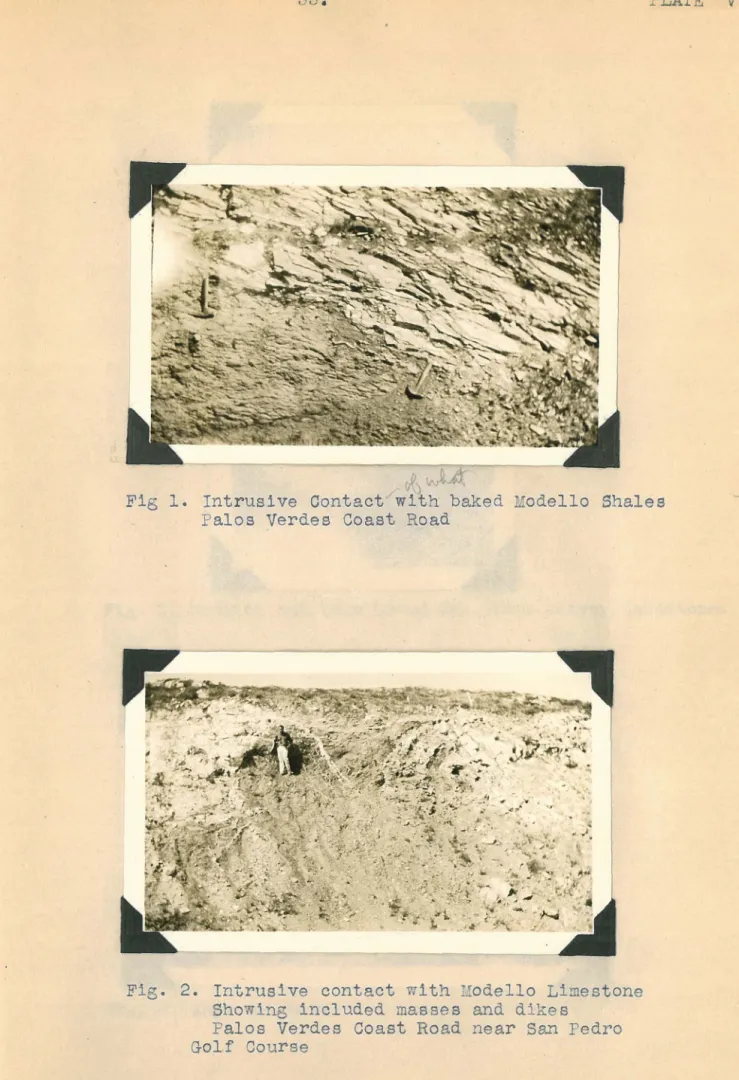
Fig 1. Intrusive Contact with baked Modello Shales Palos Verdes Coast Road
Fig. 2. Intrusive contact with Modello Limestone Showing included masses and dikes
Palos Verdes Coast Road near San Pedro Golf Course
v
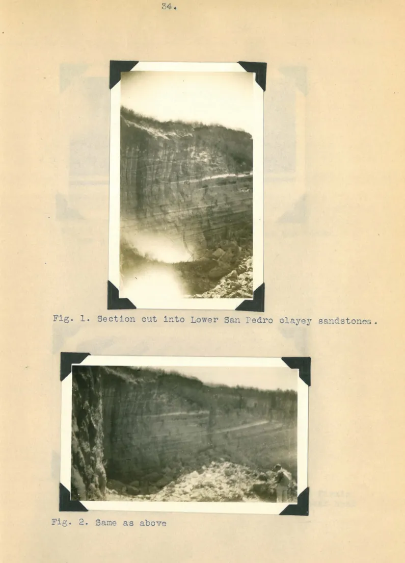
Fig. 1. Section cut into Lower San Pedro clayey sandstones.
Fig. 2. Same as above
35 •
. -~~
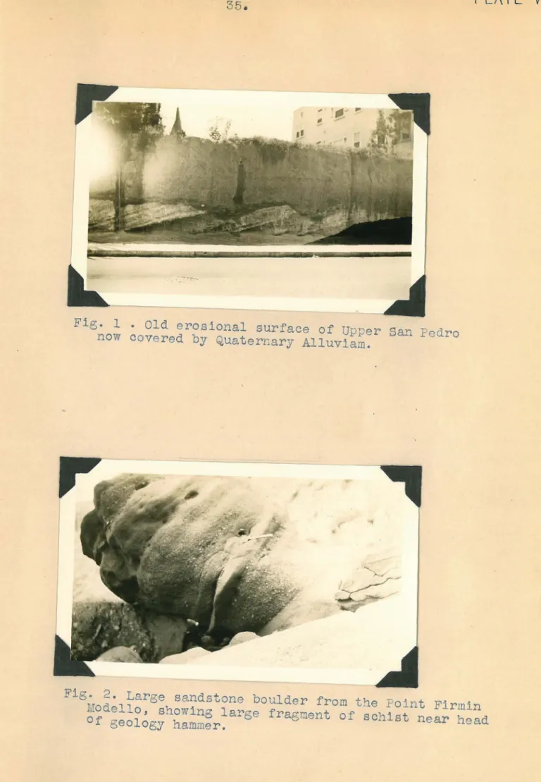
Fig. 1 • Old erosional surface of Upper San Pedro now covered by Quaternary Alluviam.
PLAT[ VII
Fig. 2. Large sandstone boulder from the Point Firmin Modello, showing large fragment of schist near head Of geology hammer.