Nevertheless, some persistent problems with the evolution of the SCS remain, such as the timing of error displacement vs. Second, the elastic thickness of the split continental crust in the SCS is thin and therefore different from that of other continental plates. What is the context between the opening of the SCS rifting and the timing of uplift and discordances in the sub-basins.
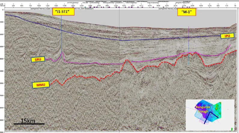
We mostly followed the second concept, mainly because of the importance of raising the hinterland in the SHS region. To avoid looking at the discrepancies in isolation, we also compare them with uplift data at the SCS periphery. Younger unconformities in the basins, especially the Intra-Pliocene Unconformity (IPU), are mainly inferred from seismic interpretation of the nearby Natuna area and the Bunguran Trough to the east.
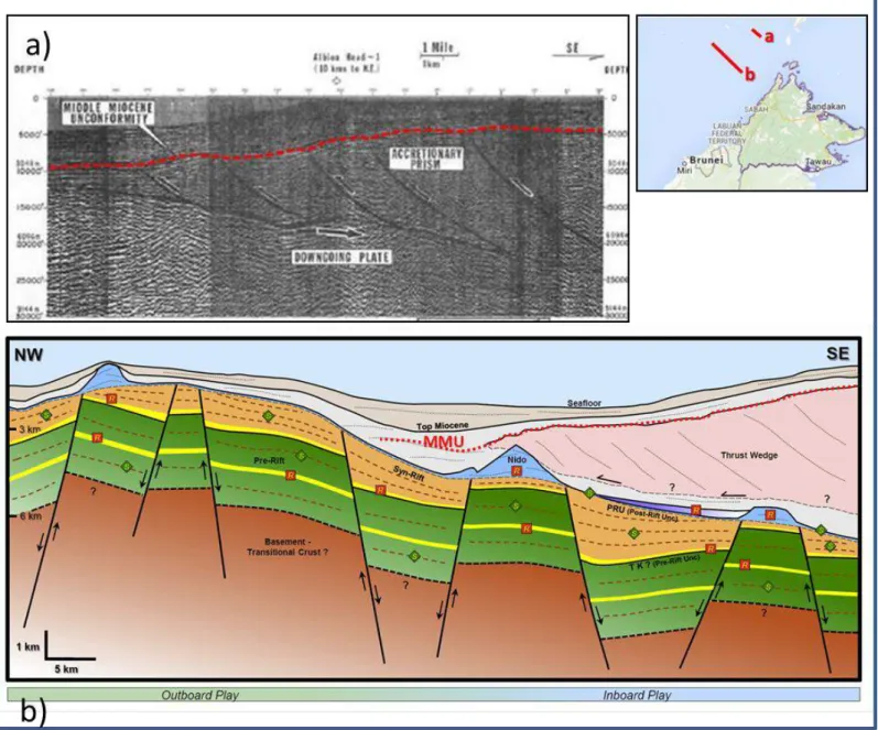
The nature of the inversion is strongly determined by the orientation of underlying fracture faults. Ryukyu Arc, as the oceanic lithosphere south of the Eurasian Plate subducts under the SCS to the east under the Philippine Plate. Active (recent) uplift can be evidenced in areas of the southern SCS periphery (Kessler & Jong, 2015a) by anomalies of the geoid and possibly caused by the monsoon.
The beginning of the formation of the basin is related to the collision of the Indian subcontinent with Asia during the Late Eocene. Deepening of the basin was accompanied by minor events of submarine erosion and non-deposition in the shelf areas. During the Eocene - Oligocene, the extension associated with the early opening of the SCS resulted in the development of NE-SW-trending half-grabens; the fill of these half grabens is continental.
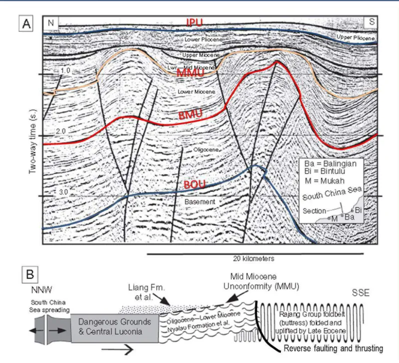
MMU BMU
BMUSRU
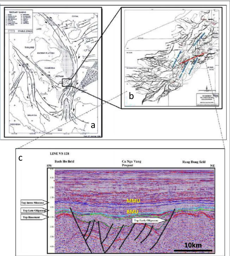
The concept that many of the SCS sub-basins originated in some way in a rifting episode and then transitioned through a syn-rift to post-rift evolution. Although often complex, the sedimentary response and tectonic development of different phases can often be related to phases in tectonostratigraphic development. Similarly, although depositional environments and the tectonic setting of rift fills can vary considerably over short distances, basic sedimentary sequence patterns and structural styles can usually be recognized and regional-scale comparisons are possible. of structural development and petroleum systems between basins with similar geological histories (Doust 2003).
According to Doust & Sumner (2007), four phases of tectonostratigraphic basin development can be recognized in the typical rift post-rift basins of the Tertiary of SE Asia: Early syn-rift, Late syn-rift, Early post-rift, and Late post-rift ; each with their own distinctive structural history and sedimentation pattern. An alternative source of plate tension and compression may be associated with the opening of a spreading center in the Celebes Sea, which occurred from 49 Ma to 44 Ma according to Longley's model (2014); Fully marine deposits occur only in the Early Miocene, perhaps with the exception of SW.
This particular difference, facies, as well as stratigraphy, is distinctly different and should be further reviewed in context with data from other SCS subbasins;. Another peak of uplift is seen at the boundary between the Oligocene and Miocene, at the beginning of the Aquitanian, ca. Given the relative paucity of data, it is difficult to say whether or not the Lower Miocene saw an extended period of uplift (from 25 to 16 Ma), or two distinct peaks as mentioned above.
A recent period of regional uplift is also recognized, beginning in the Late Tertiary at the boundary between the Miocene (Messinian) and the Pliocene (Kessler & Jong, 2015a, Jong et al., 2016). When we look at the spatial distribution of uplift data (Figure 30), we notice that some areas including Southeast China/Beibuwan history, Hainan Island; Sarawak/Kalimantan, Schwaner Mountains that have recorded uplift ages older than 40 years. The picture of the tectonic evolution of the SCS would be incomplete without addressing the opening/formation of the oceanic crust of the SCS and on adjacent plates.
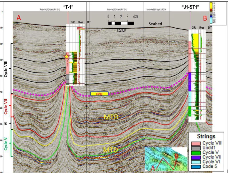
One of the earliest rifts occurred in the Celebes Sea, where oceanic crust was formed during the Eocene at ca. This rift should have created compression in the NW-SE direction, in the context of the Sarawak Orogeny. It led to the development of a triangular rift between the Paracel Islands and the Dangerous Grounds (see Hutchison, 2005 p. 6; Figures 1 & 29), with the western tip located east of the Mio-Pliocene Bunguran Trough.
Frequency
We can distinguish between inversion near the suspected southern Sundaland Plate margin, and also inversion areas in the center of the SCS. The inner parts of the SCS also saw (Oligocene and Miocene) inversion in the greater Natuna region (Figures 5a and 31). On the other hand, older inversion tectonics could be more pronounced, especially closer to the center of the SCS.
Oligocene Base of Carbohydrate Base 34 Mabase Oligocene Unconformity (BOU) in this study Indo-Australian Plate collisi on /S ar awak Ose og en y (Cullen, 20 10 ) vs. Furthermore, we must consider the effects of the opening of the SCS, and climatic factors. As the crust of the SCS stretched and subsided further, a blanket of Miocene sediment is present almost everywhere in the SCS.
The MMU is only strongly pronounced on the Sarawak/Sabah portion of the southern Sundaland margin. The unconformity appears to post-date the compression of the Sundaland plate margin by the neighboring plates. Cross-segmentation of the Baram-Balabac Basin, NW Borneo: refining the model of Borneo's tectonic evolution.
Geological development of the central and southern Vietnamese margin: implications for the creation of the South China Sea, Indochinese escapement tectonics and Cenozoic volcanism. Formation of Makassar Strait and separation between SE Kalimantan from SW Sulawesi. The North Palawan Block, Philippines: its connection with the Asian continent and its role in the evolution of the South China Sea, Bulletin of the Geological Society of Malaysia, 14, p.19-58.
A basin with several sediment sources: stratigraphic records of the Bunguran Basin, Central South China Sea. Geological evolution of the Cuu Long and Nam Con Son basins, offshore southern Vietnam, South China Sea. Ages and magnetic structures of the South China Sea constrained by deep towing magnetic surveys and IODP Expedition 349.
Deep structures of the Palawan and Sulu Seas and their implications for the opening of the South China Sea. Oligocene-Miocene carbonates and their role for limiting the rupture and collision history of the Dangerous Grounds, South China Sea.