SMITHSONIAN INSTITUTION
BureauofAmerican Ethnology Bulletin164
Anthropological Papers, No. 53
AN ARCHEOLOGICAL RECONNAISSANCE IN
SOUTHEASTERN MEXICO
By MATTHEW
W.STIRLING
213
CONTENTS
PAGE
Introduction 217
The
TonaM
region 219El Plan 220
Rfo delasPlayas 220
Ceiba Grande 221
PuebloViejo 224
San Miguel 225
Comalcalco andvicinity 226
Comalcalco Ruins 228
Parafso 229
Bellote 231
Isla 231
Tupilco 232
Tapijulapa 233
Atasta 234
Literature cited 235
Explanationofplates 237
ILLUSTRATIONS
PLATES
FOLLOWING PAGB
46. a, The village of Tapijulapa, Tabasco. 6, The Rfo de las Playas,
Veracruz 240
47. Stone headsfromthevicinity ofSanJose delCarmen 240 48. a, Housefoundation, PuebloViejo. b, BallCourt, CeibaGrande 240 49. a, Partofthe Ball Court, Ceiba Grande, b, Pavedfloor. Ball Court,
CeibaGrande 240
50. Portionofstone head,San Miguel, Tabasco 240 51. o. Theruins ofComalcalco. 6, MasonryatComalcalco 240 62. a, Stuccofigures, tomb, Comalcalco. b, Potsherd encrusted masonry,
Comalcalco 240
53. a,
Monument
from La Venta. Villahermosa. b,Monument
fromLaVenta. Comalcalco 240
54. ArtifactsfromthevicinityofVillahermosaandFrontera, Tabasco 240 55. Stuccoconstructionintheshell
mound
atCeiba, Tabasco 24056. Potteryfrom shell moundat Ceiba 240
57. Figurinesandpottery fromshell
mound
at Ceiba 24058. Potteryfromshell
mound
at Ceiba 24059. Potteryfromshell
mound
at Ceiba 24060. Potteryfigurefromshell
mound
at Ceiba 24061. Cylindricalandflatstampsfrom shell
mound
at Ceiba 240 62. Stoneartifactsfromshellmound
at Ceiba 240 63. a, Shellmound
at Bellote. &, Salt-waterchannel near Bellote. _ 240215
216 BUREAU OF AMERICAN ETHNOLOGY
[Bull.164FOLLOWING PAGE
64. a, Making lime from oyster shell, Isla. b, One of the Bellote shell
mounds 240
65. Associatedartifacts ofpottery, shell,andjadefromatombat Isla
—
240 66. Associated potteryvesselsfromatombat Isla 240 67. Potteryfigures of
Maya
typefromTupilco 24068. Adornos fromlarge urns. Tupilco 240
69. a, Stone celt from Rio Candelario. b, Hematite figure from Tapiju-
lapa 240
70. a, Engravedceltfromvicinity of Simojoval, Chiapas, b, Stonestatue
fromAtasta, Campeche 240
71. a, Pottery jaguar head from San Miguel, b, Alabaster vessel from cave near Simojoval, Chiapas, c. Portionofpotteryfigurefrom LaVenta. d, Grindingstonefromshellmound, Ceiba 240 72. a. Prowling jaguarinstucco from Atasta. b, Stuccofragmentsfrom
Atasta 240
73. Basaltmonuments fromLaVentanowatSan Vicente, Tabasco 240
TEXT FIGURE
page5. CeibaGrandesite, RfodelasPlayas 222
MAP
15.
Map
ofTehuantepec andadjacent territory 218AN ARCHEOLOGICAL RECONNAISSANCE IN
SOUTHEASTERN MEXICO
By Matthew W.
StirlingINTRODUCTION
One
of the important but little-known archeological areas ofMiddle America
is that portion of southernMexico
lyingbetween
the classicOlmec
territoryand
that formerlyoccupiedby
the ancientMaya.
In 1944 a reconnaissancewas
conducted in this region as part of the National Geographic Society-Smithsonian Institution archeological program, the primary purpose ofwhich was
to estab- lish the easternboundary
of the earlyOlmec
culture.The work was made
possibleby
fundssuppliedby
theNational Geographic Society.The
territory covered during themonths
ofMarch and
April, extendedfrom
theTonala
River eastward to theLaguna Terminos and
the Candelario River. This includes a small part of southern Veracruzand
northern Chiapas,most
of Tabasco,and
the western corner ofCampeche.
Iwas
assistedon
the tripby
RichardH.
Stewart, assistant chief of the National Geographic Photographic Laboratory,
and by my
wifeMarion
Stirling.(Map
15.)In general in this region there are very few roads; rivers
and
trailssupply the principal avenues of travel. Chartered small planes were utilized for several of the longer jumps, but for the
most
part travelwas by
launches, canoes, horseback, oron
foot.The
coast facing theBay
ofCampeche
is low.A
line of sand dunes fringes the water's edgeand
behind these dunesmangrove swamps
extendmany
miles inlandwhere
the water ismade
brackishby
the tides.Back
of thesandy
coast is a chain of large, shallow salt-water lagoons.Along most
oftheTabasco
coast, themangroves
giveway
to fresh-waterswamps
in thelow
flat interior. Thislow
land extends almost to the Chiapas borderwhere
themountains
leading to the central plateau begin.The major
portion of this territory is coveredby
a dense tropical rain forest, interspersedby
lakes,
swamps, and
large rivers,which
are joinedby
anetwork
of connecting sloughs.The
principal rivers are the Grijalva,and
the217
218 BUREAU OF AMERICAN ETHNOLOGY
[Bull.164Map
15.— Map
ofTehuantepec andadjacentterritory.San Pedro y San
Pablowhich
constitutes the lower course of the Usumacintla. In spite ofwhat might seem
an unfavorable environ- ment, the area is fairly well populated.The
1940 census gives 12 inhabitants to the square kilometer, a figurewhich
seems too high.The abundance
of archeologicalremainswould
suggest that thepopu- lation in aboriginal timeswas
greater than atpresent.A number
ofMaya
sites are to be found in this region, themost
important beingJonuta on
the lowerUsumacintla and
Comalcalcoon
theRio
Seco.The
latter is of particular interest since it represents thewesternmost-known Maya
site.Many
of the prehistoric remains, however, are not yet identifiable asMaya,
a factwhich
pointsup
the importance of doingwork
in thiskey
area. Here, theoretically, shouldbe found the chronologicalNo.^SsT^
ARCHEOLOGY, SOUTHEASTERN MEXICO
STIRLING219
link
between
the established culture columns of theMaya
region,on
the one hand,and
of the Veracruz coast,on
the other. In addition, there appear to be relationships with the highlands of Chiapas.There
is evidence also of Toltec influence, an item of considerable current interest. All in all,Tabasco and
the adjacent territory constitute a critical region of primary archeological importance.At
Comalcalco there are anumber
of interesting anomalies.The
architecturein
many
respects istypical ofthe ClassicMaya. Rooms
are
narrow
with extremely thick wallssurmounted
with steep cor- beled vaults.Tombs
contain figuresmodeled
in stucco reminiscent of Palenque,The
structures, however, aremade
of fired bricks instead of stone,and
the substructures are earthmounds
similar to those of Veracruz rather than stone-facedpyramids
with rubble cores.At
Jonuta also there are earthmounds
instead of pyramids, but typicalMaya
stone sculpture exists, withMaya
glyphs.At
Tupilco, near the coast of Tabasco,we
found a site without architecture but with typicalMaya
figuresmodeled
in clay. Thissite lies
some
30 miles west of Comalcalcoand
is the westernmostMaya
outpostyetknown.
THE TONALA REGION
The
Tonald River, theboundary between
the States of Veracruzand
Tabasco, is formedby
the junction oftwo
streams, the Pedregaland
the Rio de las Playas,which
originate in the roughmountains
around the CerroMono
Pelado. After flowing their separateways
through themountains
they join soon after entering the coastal plain.At
the present time the regionwhich
they drain is entirely uninhabited exceptfor the lower reaches.While
working at the site ofLa Venta
in 1943,we
heard stories of ruinsknown
as Pueblo Viejo, locatedon
the Rio de las Playas.On many maps
ofMexico
this site appears in large type as though itwas an
existing city.Unable
to findanyone who had
been there,we became
intriguedand
resolved tomake
a tripup
the river inan
effort to locate it.
Our
unsuccessful attempt todo
so at that time hasbeendescribed elsewhere (Stirling, 1943;Weber,
1945).However, on
this 1943 tripwe
obtained information that convinced us of the existence of the ruins of Pueblo Viejo,which we presumed was
a colonial site.We
were told also of a large pre-Columbian site in thevicinityknown
onlyto oneman,
Vicente Aguilar, a native pioneer livingon
the Rio de las Playas,who was
unavailable to us as guideon
ourfirst expedition.On March
11, 1944, Stewart, Mrs. Stirling,and
I leftLa Venta
in a canoe withan outboard motor, in ordertosurvey theupperreaches of the river.Having
heard of amound
group near the oilcamp
of220 BUREAU OF AMERICAN ETHNOLOGY
[Bull. 164Cuichapa,
we made
ourfirststop atLas Choapas and
tooktheautovia car to theoilcamp.
Here
oneoftheengineers,Roberto Montez,
ledusto thesite,which
IS about 3 miles west of Cuichapa.
The
group is quite impressive, consistingofaverylargelongmound
approximately 500feetlongand
40 feet high. Just east of it is a steep conicalmound
about 50 feet high.South
of this are several smallround mounds. We found no
sherdson
the surface.Although
themounds had
been cleared 2 years before our visit, theyhad
againbecome
covered with a dense second-growthjungle.Leaving Las Choapas we
continuedup
the river.At
El Plan thefirsthigh
banks
appear alongtheriver,and
themangrove swamps
are leftbehind.EL PLAN
At El
Plan, formerlyknown
as Huacapal, there aretwo mounds
about 50 yardsfrom
the edge of the 50-foot-high riverbank.The
largest of these is about 14 feet high
and
isdome
shaped. In front of it, in the direction of the river, is alow
irregularmound
about 5 feethigh.Some
digginghad
beendone on
the east edgeofthelargermound, but
ithad
not beenmuch damaged. The
spacelyingbetween themounds and
the riverwas
evidentlyan
occupation site, sinceabundant
sherds are revealedwhere
digging has beendone
for con- structionpurposes.These
sherds are forthemost
part ofplain buffware
with black interspace as the result of incomplete firing.They
are undecorated except for simple grooves or incising near the rims.
The
principal shapes notedwere
shallow, fiat-bottomed bowls with widely everted rims.A
few obsidian flakesand
flint chips were scattered around.No
figurine fragmentswere seen.
RfO DE LAS PLAYAS
Beyond
the mangroves, the country continued low, with hereand
therelow
hillsand
elevations. Occasional milpas along the riverwere
planted primarily with cornbut
withsome
beansand
bananas.When we
entered theRio
deLas
Playas theriverbanksbecame much
higher. AscendingthePlayasfor 1
hour we came
toalow
hillon
theleft, with a sandstone exposure at theriver's edge. Just
back
of thison
a higher elevation could be seen a group ofmounds and
leveled terraces silhouetted against the sky.An
hour's journeybeyond
this pointwe saw
anothermound
groupon
a highpointback
ofthe riveron
theright.At
Cerro Pil6n the river emergesfrom
the mountains, the rapids begin,and
it isno
longer possible to use a motor.Here
the riverNo.^SsT^^ ^^'
ARCHEOLOGY, SOUTHEASTERN MEXICO —STIRLING 221
passesthrougha
Hmestone
gorgeand
theremainderof thetripis slowand
difficult.The
regionbeing uninhabited, thereisno
land trailup
the river. Justbeyond
the gorge, at the lasthouseon
the river,we
picked
up
our guide, Vicente Aguilar.Near
the house a good-sized stream, theArroyo
deLas
Amates, entersthePlayason
theleft bank.Vicente told us that
on
a hunting triphe had
seen a ruin fartherup
thisstream.
To
reach it one goes2 leaguesup
the Amates,where
it is joinedby
theArroyo
Burro.Then
one follows theBurro
to the west until theArroyo Esperanza
enters it.Near
the headwaters of the Esperanza is a good-sized site with stone-faced platforms, larger than Pueblo Viejo but smaller than Ceiba Grande, thetwo
siteswe examined on
theRio
delas Playas.From Las Amates
it is about 3 days' travel to theArroyo
Pueblo Viejo,on which
are located the ruins of the site of thesame name.
On
the thirdday we
stopped justbelow
a mountain, locally called the Cerro Tierra Colorado, in order tohunt
game.At
this place the leftbank
oftheriverishighand
thelandquitelevelfora considerable distance.Here
along a smallarroyowe saw
aseriesofsmallmounds,
the highest ofwhich was
about 10 feet.Some
were circular inform and
others were of an elongated oval shape.Most had
sandstone slabs scatteredon
the surface.We saw
one natural outcrop of thistype ofstone inthe vicinity
which
gaveussome doubt
as to the arti- ficial nature of themounds. However
their appearanceand
location leadme
tobelieve that they aremanmade.
Itwould have
cost us aday
of travel to testthem, sowe
didnot excavate.CEIBA GRANDE
About noon
of the thu'dday
of our tripfrom
the limestone gorge,we came
to a small arroyowhich
entersfrom
the leftbank
of the Playas opposite a highbank
of blue shale topped with reddish soil.We
gave it thename
ofArroyo
Vicente.The
large prehistoric site,Vicenteassuredus,
was
locatedon
thisstream. After a4-hoursearch, he found it. It is situated on the rightbank
of the arroyo on fairly levelground and was
covered with a very highgrowth
of virgin jungle.A
giant ceiba treewas
growingon
the exact center of thesummit
of the principal pyramid, so
we named
the site "Ceiba Grande."Because of the
heavy
jungle cloak, the real natureand
extent of the sitewas
not apparent to us at first, but after 5 days of clearingand
mapping,we
found that it consisted of aprincipal pyramid,two
adjacent courts,and
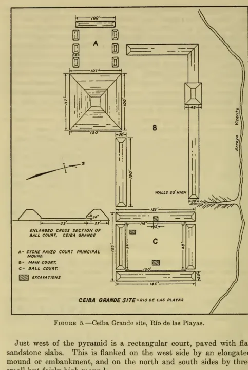
aball court (fig. 5).The pyramid
is approximately 50 feethighand
is faced with sand- stone slabs.A
badly ruined wide stairway leads to thesummit on
the north side.222 BUREAU OF AMERICAN ETHNOLOGY
[Bull. 164A- STONE PAVeO COURT PRINCIPAL MOUND.
B- MAIN COURT.
C- BALL COURT.
KSS$Si EXCAVATIONS
CEIBA ORANDESITE-Riooelas playas
Figure 5.
—
CeibaGrandesite, Rfo delas Playas.Just west of the
pyramid
is a rectangular court,paved
with flatsandstone slabs. This is flanked
on
the west sideby an
elongatedmound
orembankment, and on
the northand
south sidesby
three small but fairly highmounds.
North
of thepyramid
is a large court about 400 feet longand
100 feet wide. This is flankedon
the northand
west sidesby
an L- shapedembankment. The
long or north area of theL
is enlarged, at the point opposite the pyramid, into a fair-sizedmound. The
NrssT^'^^^"
ARCHEOLOGY, SOUTHEASTERN MEXICO —STIRLING 223
southside ofthe big courtisflankedin part
by
thenorthwallofcourt"A,"
the principal pyramid,and by an embankment which
extends eastwardfrom
the northeast corner of thepyramid
for a distance of 190 feet. Thisembankment
runs level fora distanceof 140 feetand
then slopesdownward
toward the ball court,which
lies at a lowerlevel.
The
east wall of the big court isformed by
the west wall of theball court.The
ball court itself, although it appears symmetrical to the eye, actually is not.The
insidemeasurements
of the northand
south ends are, respectively, 48 feetand
56 feet, while the inside measure-ments
of the eastand
west sides are 120 feetand
116 feet. Part of thisapparentirregularitymay
bedue
tothefactthat the innerpaving has been buried in the taluswashed down from
the surroundingembankments.
The
structures at the northand
south ends of the ball court aresomewhat
shorter than the width of the floor, leaving anarrow
passage at each corner.The
entire surface ofthe walls is faced withflatslabs ofsandstone,
and
thebaseofeachwall hasavertical sectionwhich
extends 2}^ feetabove
the floor.From
this point the walls slopeupward
at an angle of45° to the top ofthewall,which
isabout 20 feet high.The
floor has been fully leveledand
consists of a well- fitted paving of sandstone slabs laidon
a base of clean yellow sand.This sand is not a natural formation, but
was
apparently carried in (pi. 49, 6).The
only excavationswe made
were in the ball court.We dug two
small pits into the floorand
ran a trench 12 feet wide into the central section of the west wallfrom
the floorlevel, in order to gain amore
accurate picture ofthe construction ofthe court. Thistrench yielded a fair sampling of sherds.There
wereno
figurines, butwe
encountered a few prismatic obsidian flakes.The
great majority of the sherds were of a coarse brickRed Ware,
undecoratedand
sand tempered.A
few sherds of this type were black,which may have
been an accident offiring.There
were also a few thin sherds offineuntempered
paste.There
were no sherdson
the surface nor couldwe
findany
in thebed
of the arroyo adjacent to the site.Inthedenseforestsouthofthe
pyramid we saw some more mounds,
but did nothave
time to survey them.An
interesting feature of CeibaGrande
is the fact thatmost
ifnot all of the
mounds and embankments
are faced with stone slabs.This feature, along with the
paved
courtsand
ball court, clearly indicates that this site is something quite differentfrom
themound
groups of the adjacent coastal-plain region of southern Veracruz
and
Tabasco. Rather, itwould seem
to bean
outpost of a culture originatingin theChiapashighlands.The
ballcourtswhich we
foimd224 BUREAU OF AMERICAN ETHNOLOGY
[Bull. 164in Chiapas in the region of the
La Venta
Riverwere ofthe expanded-end
typefor themost
part, but nevertheless I feel that theremay
besome
relationship.PUEBLO VIEJO
A
short distanceabove
theArroyo
Vicente, theArroyo
Pueblo Viejo enters the riverfrom
the left bank. Directly in front of the arroyomouth,
there is a large bar.A
short distanceabove
this is a secondlarge bar. Justback
ofthis, thesiteofPuebloViejo islocatedon
highlevelground on
the rightbank
of theriver.The
site is near theriverand
liesbetween
itand
a small arroyowhich
entersthePlayas just below.The
site is about 400 yards square,and
consists of ap- proximately 30 rectangular platforms withmasonry
wallsmade
of flat slabs ofsandstonelaidwithout cement.They
arebetween
2and
3 feet high, depending
on
the size of the platform.The
largestwe measured was
66by
30 feetand
the smallest 25by
10.We
selected one forexcavationwhich was
30by
18 feet,withwalls2 feet 10 inches high.At
a distance of 7 feet 7 inchesfrom
the northwest corner therewas
a stone staircase 17 inches wide consisting of 3 steps, each with a rise of 7 inches.The
long axis of the platformwas
oriented almost exactly northand
south. This appeared to be the case with the other platforms as well.The
spacebetween
the stone wallswas
filled with earth, level with the top.
We dug
a trench 5 feet wide extendingfrom
the middle of the north wall to the middle of the south walland
an intersecting trench connecting the centers of the eastand
westwalls. (PI. 48, a.)A
considerableamount
of plain buff potsherdsand
a quantityof flint chipsand
rejects were recovered.The
onlyEuropean
object foundwas
alarge square hand-forged iron spike. Thislayat a depth of 1 footnear the middle of the platform.At
the north edge of the site aretwo
deep excavations or holes.On
the rim of one of these are the remains of part of a stone wall.They might have
been wells, but it isdifficult to seewhy
wellswould have
beennecessarywith the riverso close athand.My
firstimpres-sion
was
that this sitewas
of colonial originand had
been occupiedby
mestizos or Europeans. This thoughtwas
induced primarilyby
thefact that
we
expectedit to be acolonial sitesinceitwas
placedon
the oldmaps.
Thisseemed
tobe confirmedby
the findingofthe iron spike,thestonesteps,and
the rather exact orientationofthestructures.On
the other hand, the potterywas
all of native type (a fact not necessarily conclusive),and
themasonry was
very similar to that of structureswe
later foundin the vicinity ofOcozocoautla in Chiapas.My
present behef is that Pueblo Viejo is a late-type aboriginal site.nS.^'^sT''"
^'''''
ARCHEOLOGY, SOUTHEASTERN MEXICO —STIRLING 225
SAN MIGUEL
Leaving
Coatzacoalcosby
small plane,we went
to Cardenas by-way
ofComalcalcoand
Villabermosa.From Cardenas we
biredmulesand
a guideand
rode tbe 42 miles toSan Miguel
in 12 bours.Tbe
first part of tbe trail is tbrougb comparatively open country
and
remains so until after crossing tbeArroyo Limon, wbere
itenters tbe forest.At Limon
tbereis asizablegroup ofsmallmounds, and
about 5 miles beyond, near tbe trail, is anotber similar group.At
botb of tbese sites, sberds arevisibleon
tbesurface. Justbeyond Limon
the trail passes over a pair of small parallel longmounds.
San Fernando
is tbe ruin of a former baciendawbicb
stood at tbis place.Tbe
trail crosses tbe ruins of a brick structure.At
onepointit passes
between two
standingbrick columns.A
few yardsback
of tbese, bidden in tbe tbick brusb,was an
aboriginal stone figurewbicb we
laterlearnedbad
been brougbtfrom
tbe site atSan Miguel by
aman named
Villar,many
years agowben
tbe baciendawas
in operation.Tbe
figure is of basalt, representing a seated individual. It is4K
feet bigb.Tbe bead
is tbe bigb elongatedOlmec
type.Tbe
ears are rectanguloid, longand
narrow.Tbe
eyes arealmond
sbapedand
slanting.
Tbe
features are badly erodedand now
almost indis- tinguisbable.Tbe
baseis flat.Tbe
I^neesand arms
are broken.Tbe
present village ofSan Miguel
consists of a few scattered thatcbed butsand
is locatedon
an arcbeological site. It is near tbe beadwatersof tbe Blasillo River, on tbe lower reacbes ofwbicb
is tbe site ofLa
Venta.Tbe
arcbeological site ofSan Miguel
consists of anumber
of good-sizedmounds and
a deeppond
orborrow
pit similar to thoseatCerro delasMesas and San
Lorenzo.Tbe most
interestingmonument wbicb
vv^esaw
attbesitewas
lyingin tbe trailbetween two mounds. One
oftbesemounds many
yearsagobad
been flattenedon
top in order to build a church ofthatch.At
the time ofour visit tbe churchbad
beenabandoned and was
falling to pieces.Tbe
stone consists of thedome-shaped
upper portion of a large basalt bead, brokenoffat thelevelofthe eyes. Initspresent conditionit isaboutSji feet high. Scattered over the
roimded head
are a half dozen ormore round
faces, includingonedirectlyon top.Each
ofthesefacesissurrounded
by
a circlefrom which
radiate five stepped elementsand
a long triangularpoint at thebase.Some
oftbe smaller faceson
tbeback
appear tohave
beenrubbed
orworn
off.The
rear of thebead
is flattened as is the case with the
Olmec
Colossal beads. (PI. 50.)About
300 yards south of tbis stone, well hidden in tbe jungle,was
another fragment ofwhat bad
evidently been a large stonemonument. One
surface of this issmooth
with a deep groove in it.226 BUREAU OF AMERICAN ETHNOLOGY
[Bull. 164Carved on
thissmooth
surface inlow
relief are three "flame"- or leaf-shaped elementssomewhat
like the carvings inlow
reliefback
ofthe
head
ofthe principalfigm-e of altar4 atLa
Venta. Itisimpos- siblenow
to tell the natm-e of themonument from which
this rather massive fragmentwas
broken.We
were informedby
themen
of the village that a few years ago in anearby
field part of a carved basalt figurewas
exposed.Being
curious, they
dug
itup and
foundittobethefigure ofaman somewhat
larger than life size. Their curiosity satisfied, they reburied it.
At
the time of our visit the field
was
covered with aheavy growth
of zacate,but
themen
claimed they could locate the figure later in the seasonwhen
the grasswas
burned.One man had
a small pottery hollowfigurinehead
ofa jaguar withround
ears. Itismade
ofalight buffware which had
oncebeen
covered with a whitesHp. (PI. 71, a.)WhUe
nota particularly large site,San Miguel
isimportant because ofits obviousOlmec
affiliations.Upon
our arrival therewe
learned that the hard 12-hour ride to reach itwas
not necessary.A
launch leavesLas Choapas on
theTonala
River tvidce aweek and
goes toArroyo
Prieto notmore
than 5 milesfrom San
Miguel.From
there one can reachthesiteon
foot orby
horseback. Itis alsomuch
closerby
trailfrom La Venta
than it isfrom
Cardenas.COMALCALCO AND VICINITY
From Cardenas
to Comalcalcowe
traveled in a truck overan unimproved
road.Most
of this section is a rich agricultural district.The
roadwas
linedwithlargecacaoplantationswhich
wereovergrown and
neglected at the timewe
passedby
them.Such
productivelands couldhave
supported a very large aboriginal population.The
present city of Comalcalco is locatedon an
island in theRio
Seco,and
it has a population of approximately 3,000.One
of ourfirst acts
upon
arrivalwas
to visit Prof.Rosendo Taracena
at the Instituto Comalcalco, a school forwhich
hewas
largely responsible.In the school
was
a considerable archeological collection that hehad
assembledfrom
the region. Included in the material weremany
specimens recently obtained
from
the large shellmound
at Ceiba, near Paraiso,from which was
taken the shell used in building thenewly
completed roadfrom
Comalcalco to Paraiso.The
place ofhonor
in the collections is heldby
a basalt seated figurefrom La
Venta. This
was
placed in a corner partly coveredby
awooden
frame designed toresemble the arched nicheson
theLa Venta
altars.This figure
was
one offivewhich
a wealthymahogany
dealerby
thename
ofPolicarpo Valenzuelahad removed from
the site atLa Venta
more
than50 years agoand
brought to hishaciendaSan
Vicente,nearAldama
in Tabasco. InAldama
the greatMexican
RevolutionNo.^^sT^^
ARCHEOLOGY, SOUTHEASTERN MEXICO
STIRLING227
began,
and San
Vicentewas
the first of the haciendas of the big landowners to be destroyed.The
fiveLa Venta monuments
layamong
the ruinsformany
yearsuntiltwo
ofthem
weretransportedto Villahermosawhere
they were placed in the grounds of the school(pi. 53, a). In 1939 Professor
Taracena removed
a third one to his institute in Comalcalco (pi. 53, b). Laterwe made
a trip toSan
Vicente to seeand
photograph thetwo
remainingmonuments. At
the timeofour visit, theroad
from
Comalcalco toAldama had
prettymuch
gone to ruin,and
itwas
with considerable difiiculty thatwe
reachedAldama by
car.Aldama,
the "Lexington" of Mexico, once a prosperoustown now
consists of a few scattered thatch hutsand adobe
housesaround
a largeopen
plaza inwhich
are anumber
ofcement
seats.Here was
fought the first battle of theMexican
Revolutionin 1910.The
roadfrom Aldama
toSan
Vicente proved to be impassable for our car, sowe made most
ofiton
foot.Along
the road, just outside Comalcalco, aretwo
smallmounds where
a brick factorywas
being built.Halfway between
Comalcalcoand Aldama, on
theArroyo
Seco at the site of the oldPemex camp,
is a fair-sizedmound and some
smaller ones.The
trailfrom Aldama
toSan
Vicente passes oversome
smallmounds
about three-fourths of theway from Aldama. There
are sherdson
the surface.The
remainsofthehaciendaare laiownlocallyas the"Casa
Vieja."The
ruins of the once fine structure arenow
buried in jungle.The
broken brick walls wi'apped in strangler figsand
covered with para- sitic plants look as ancient asany Maya
ruin, although itwas
only 1913when
the haciendawas
destroyed completely.Lying
in the rubble of the old patio,we
found thetwo monuments. Under
the circimistances theyseemed
to us to epitomize theimpermanence
ofhuman
achievement. Policarpo tookthem from
the wildernesswhich
the great centerofLa Venta had
become,and
broughtthem
towhat
he considered the luxuriouspermanence
of the great hacienda.Now La Venta
is, as a result of the oil industry, oncemore
at the doorstep of civilizationand
easily accessible, whileSan
Vicente, in utterruin,isburiedina wilderness ascompleteasthatwhich
formerly engulfedLa
Venta.One
of the stones, 45 inches high, represents aman
sitting cross- legged, leaning forward shghtly, thehands
clasping the feet.A
band
across the forehead passes completelyaround
the head.The
facial featm*es are considerably eroded,
and
part of theupper
leftarm
has been battered off; otherwise the sculptureis in prettygood
condition (pi. 73, a).37092&—57 17
228 BUREAU OP AMERICAN ETHNOLOGY
[Bull. 164The
other stone, 36 inches high, is especially interesting. It represents theOlmec anthropomorphic
jaguar in parthuman,
part animal posture.The
figure is seated with the left frontpaw drawn
under the body, the rightpaw
lying alongside thebody
with the realistically carved foot lying pads up.The head
is largeand
represented as looking upward.The
elongated eyeshave
branching"Olmec"
eyebrowsand
themouth
is the typicalOlmec
"tigermouth."
The
forehead issomewhat
concaveand
thehead
flat across the top, with the usual notch in the middle of the forehead.The
tail is stylizedand shown
as branchingon
each side like theeyebrow
conventionalization.A
fresh breakshowed
thatsomeone
very recentlyhad knocked
off the base of the tail.The
piece soremoved must have
been carried away, sincewe
searchedfor itin vain. (PI. 73, b.)A
figure quite similar in appearancewas
found atArroyo
Sonso, 25 kilometers southeast of Coatzacoalcosand
15 kilometersfrom
theTonala
Kiver(Nomland,
1932).These two monuments
are relatively small asLa Venta
sculpture goes.The
bases ofboth
pieces are perfectly flat, that of the jaguar having an opening through itwhich
passes through the lap.COMALCALCO BUINS
The Maya
ruins ofComalcalco lieon
the right side of theKIo
Secoand
less than an hour'swalk from
the town. Considering therelative accessibility of the siteand
its great importance, it issomewhat
difficult to understand
why
it has been so neglectedby
archeologists.Charnay
visited the ruins for 10 days in 1880, publishing several inadequate accounts, but quite properly calling attention to the importance ofthe site (Charnay, 1887). (Pis. 51, a, b; 52, 6.)In 1925 the
Tulane
University expedition under the direction of FransBlom
(1926-27) visitedand mapped
thesite, excavating atomb
containing a procession of figures
modeled
in stucco. (PI. 52, a.)Save
for thesetwo
brief forays, archeologistshave managed
pretty successfully to detouraway from
the locality.The
principalmound
isacompositestructure
more
orlessrectangularinform
withtwo
large apronsprojectingfrom
thewestcorners. Itismore
than 100feethighand
probably measures almost 1,000 feet along the east-west axis.The
remains of the buildings still standing are of large, flat well-fired brickssetinheavy mortar made from burned
oystershell.The
walls aremore
than3 feet thick.Although some
oftherooms
arestillintact, the site has been pretty welldenuded
of all the paintingsand
stucco"adornos"
which
once embellished it.The tomb
excavatedby Blom had become
exposed to the weatherand
the stucco reliefs were deteriorating although still in fair shape.No.^S"^"^"^^^
ARCHEOLOGY, SOUTHEASTERN MEXICO
STIRLING229
All oftheglyphs in the
tomb
were gone. It is possible that similartombs
occm-under the corresponding apronon
thenorthwest portion ofthemound.
Many
years ago themajor
part of the walls of themain
buildingwas
torndown
in order toobtain bricks to buildhouses nearComal-
calco. Despite the wreckage of the structures
which surmounted
thesite, therehasbeenvirtually
no
excavationin themounds
themselves, so in one sense the vandalism has been superficial. Because of its strategic location as the westernmost outpost of the ancientMaya
civilization, Comalcalco offers a splendid opportunity for finding in juxtaposition, materials typical of thesouthern Veracruz cultures
and
those oftheMaya
proper.Although
the buildings are architecturally pureMaya,
the substructuresresemble the large earthmounds
of the southern Veracruz areamuch more
than they dothe stone-facedMaya
pyramids.
While
finestuccomodelingreminiscentofthatatPalenquewas
characteristic of Comalcalco, stone sculpture seems to be absent.PARAISO
The
tripfrom
Comalcalco to Paraiso over thenew
shell-surfaced roadrequiredonly 30 minutesby
car.The
roadisitselfan
attenuated archeological site, beingcomposed
ofa mixtureofshelland
potsherdsfrom
the great shellmound
nearCeibaon
the lowerRio Seco.Paraiso, a
town
with a population of about 1,800, has apparently not changedmuch from
its appearancewhen
visitedby Charnay
in 1880.While
intown we
viewedsome
private collections of materials thatcame from
the shellmound
duringthe road-buildingperiod.The
shellmound was
locatedon
theleftbank
oftheRio
Seco about a mile above Ceibain thedirection ofParaiso.The
locationwhere
themound was
actually situatedisknown
asPalma, butsince Ceibaisthe betterknown
place, Iam
referring to it as the CeibaMound.
When we
visited the site the bulk of themound had
been hauled away, butsince thebasestillremained withnumerous
excavationpits exhibitingvertical faces 8 or 10 feet high,itwas
stillveryinstructive.The body
of themound
goesdown
well below the water tablewhich
is at the surfacelevel oftheriver.
At
the time of ourvisitsome
shellwas
stillbeing takenfrom
themound.
The
baseofthemound was
about 300 yardslongby
100yardswide.Our
informants toldus that the highest partformerly reacheda height of 15 meters.The body
ofthemound
consistedmainlyofoystershellwith occasional pockets of conch shell, sand,
and
stray miscellaneous shells. Floors,bothofburned
clayand
cement, arefairlyabundant
in the remaining lowerportion ofthemound.
In severalinstances cross sectionsshow
3 or 4 floors superimposed (pi. 55, a).The
layers ofcement
are about aninch thickand
were usually the sidesand
topsof230 BUREAU OF AMERICAN ETHNOLOGY
[Bull. 164 rectangular platforms with shell cores.The
corners of the platformswere rounded and
the walls slopedtoward
the top so that each plat-form was
actuallyintheform
ofamuch
truncatedpyramid
(pi. 55, 6).A man who
lived at the site all during the period of excavation said that there were usuallyhuman
burials with offerings beneath these platforms,which
rangedfrom
2 to 4 feet in height. According to his account,which
accorded withwhat
otherinformants told us,most
of the betterspecimenscame from
theupper
levels of themound. The
highest
summit had
immediately under the surface alargecement
or stucco-covered platform, the sides ofwhich
were decorated with"alligators"
modeled
in stucco relief. Thismade
a rather impressive appearance,and
the worlonen, hopeful of treasure, lostno
time tearingitapart onlyto findthat theinteriorconsistedofapureoyster- shell core.Among
the findswhich
our informantremembered was
a string of pure white, highly polished stone beads, little pinch pots filled with red paint,some
legless stone metates,and
a stone "idolo"about2 feet high representing a seated
man.
Here and
therein themound
canstillbeseen depositsofwhite limemade by
burning oyster shell. Potsherds wereabundant
with the base ofthemound
sowell exposedand
freshlyexcavated;half vessels, large rimsherds,and
basal supports lay about in profusion,many
in situ. This materialwas
representative of the early period of themound
structure.Some
of the sherds are of incised ware, occasion- ally with zoned designs set offby
punctate areas. Paintedware
is eithermonochrome,
darkred (specular hematite), orpolychrome
con- sisting of orangeand
blackon
buff.A good many
of the vesselshad
acream
slipon
the exterior, butno
further painting. All the painted designswe saw
were geometric in character.There
were partsofcomales,withouthandles,and
fragmentsoflargeollas.There was
another type of large shallow vessel withround bottom and
a shortincurvingneck
with wide everted rim.Some
of these, judgingfrom
the sherds,must have
been 18 inches in diameter. Figurines appear to be relatively rare, such as there are, being of the hollow variety.The
finerware
consists of shallow tetrapod vessels, usually with fluted melonlike sidesand
flange base. Effigy ormammiform
supports terminatein aflat cylindricalnubbin.
Some
sherds revealed thata shallow annular or ringbasewas
sometimes used.A common
typewas
around-bottomed
jar wnth sloping shoulderand
a high neck, therounded
portionbelow
the shoulder being roughenedby
textile impressions or scalloping applied with the edge ofa pecten shell.There was
apparentlyno
shell tempering.The
nature of the ceramics is bestshown by
the illustrations (pis. 56-61).No^SsT^"
^'^'^'
ARCHEOLOGY, SOUTHEASTERN MEXICO —STIRLING 231
BELLOTE
From
Ceibawe
droveby
cartotheendof theroadwhere we
hired a canoetovisitthe shellmounds on
theLaguna Mecoacan. We
passed miles of coconut groves alonglow mangrove
flats inan
area similar to thatofthe 10,000 island region of Florida (pi. 63, b).We
passed several smallshellmounds
withsections exposedby
the waves. In alittlemore
than 2 hourswe
reached Bellote,where
the bigmound
group is situatedon Andres
Garcia Island.There was
a thatchedhouseatthe footofthemounds owned by
R. Unolfo Cordoba,who
guided usover themounds which
hehad
partly cleared forculti- vation. (Pis. 63, a; 64, b.)The
Bellote group is quite impressive.There
are four principalmounds
placed in close proximityand
several smaller scatteredmounds,
principally toward thenorthand
east.The
sides ofthemounds
aresteepand do
not runtogether aimlessly in the usualmanner
ofshellmidden mounds.
The
centralmound
ismore
than 40 feet highand
ismore
or less flaton
topwhere
parts of acement
floormay
still be seen.At
asomewhat
lower level on the east side is a flat-topped apron. Just south of this is a slightljT" lower, steep symmetrical conicalmound.
East of the central
mound
is a large,somewhat
elongatedmound
about 25 or 30 feet high, while north of thecentral
mound
is anothermound
withtwo
summits, probablylessthan20feet in height.North
of this are three low, elongated
mounds
running parallel with their axis inan
east-west direction.Our
guide told us that in clearing his milpa they foundsome
glass beadsoflargesize.Potsherds were
abundant on
the surface,and on
superficial exami- nationseemed
similar to theware
at Ceiba.Although
ofshell, the Bellotemounds seem
definitely tohave
been constructed,and
arenot simply refuse heaps.When Charnay
visited Bellote around 1880, he said there werestill ruins of a temple on the
summit
of the principalmound, and
pictured a stuccorelief similar in style to those at Palenque.When we
visited the site, the only visible evidence of a structurewas
theremainsof acement
floor.ISLA
On
our return tripfrom
Bellotewe
stopped to photographsome
natives burninglime in a fashion thatmight have
been usedby
the aboriginalinhabitants,who
alsomade
limefrom
oystershells.A
sort of crib ofmangrove wood was
constructed, forming a plat-form which was heaped
high with oyster shells. Thiswas
fired, reducing the shells to lime (pi. 64, a).232 BUREAU OF AMERICAN ETHNOLOGY
[BnLi..164At
a place called Isla, not farfrom
this point,we
stopped tosee aman by
thename
of Francisco Chable.He and
his sonhad
justdug
a smallmound on
hisproperty,and we made
photographs of the interesting material recovered.The mound was
of earthand
about 5 feet high. In thebody
of themound
were three pottery vessels.One was
a round-bodied spouted" teapot," theupperpartpainted darkredand
highlypolished, the lower part incised (pi. 65, a-1).The
spoutis unsupported, the base flatwithavestigial annularringsupport.The
othertwo
vessels were incrusted with "caliche"and
the painted decoration, if any, did not show.The ware
ofboth
of thesewas
brick red in color.One was
a round-bottomed, high-necked jar with the rimexpanded
intobowl
form. Itwas
9 incheshigh (pi.65, a-3).The
otherwas
awide-mouth
jarwith simple incised ornamentation (pi. 65, a-2).Below
the base of themound was
a grave about 4 feet deep, with traces of thebones ofa child.Accompanying
thesewereanumber
of artifacts.There were two
pottery vessels.One was
a spouted effigy pot of incised buff-coloredware
11 inches high, the other a pot of exceptionally fineware
in theform
of a coiled shell, 9by
8 inches.The
latterhad
shortcylindricaltripod supports,and
ashort spout,and
theinteriorwas
painteddarkredand was
highlypolished.The
outsidewas
covered with acream
slip.On
the sidewas
a rectangular car- touche with an elaboratelymodeled
designwhich
probablyrepresents a stylized serpenthead
(pi. 66, a, h).Also with the burial
was
the profile of ahuman
skull carvedfrom
shell, about 3 inches in diameter,
and
a pure white, well-preservedhuman
head, beautifully carvedand
polished,made from
a massive piece ofsome
marine shell. It is IK inchesin height.With
it were 7 cylindricalshell beadsand
15 bright green jade beads,and
a pair of very small earspools of thesame
material.The
shellhead was
in position as the central piece of the jadebead
necklace.There was
also astring of 12 polished
and
perforated shells (pi. 65, h, c).TUPILCO
From
Paraisowe
drove to the finca of AlejandriaMarques
Gutier- rez,widow
of GeneralGutierrezwhose
fatherwas
killed in the battle ofAldama.
She had
a veryinteresting collectionmade by
herhusband on what had
formerlybeenhisproperty,nearTupilco.The
material consisted primarilyofelaborate"adornos"inMaya
stylewhich had
been brokenfrom
large cylindricalm-nsorincensarios.The
best pieceis alife-sizehead
wearing a jaguar headdress. Part of therim
of the cylindrical urn towhich
ithad
been attached is still present. (Pis. 67, 68.)Noi^fsT^
ARCHEOLOGY, SOUTHEASTERN MEXICO —STIRLING 233
The
presence of aMaya
site at Tupilco is of considerable interest, since thiswould make
it the westernmostMaya
outpost yetknown.
The
siteconsistedofsmallshellmounds
withno
otherarchitectural features.TAPIJULAPA
The
picturesquetown
of Tapijulapa is situated at the base of the central mountains, at the junction of the Escal6nand
Oxolatdn Rivers in the extreme southwestern part of Tabasco.There was
formerlyan
archeological site here near the river,and
specimens are occasionally foundon
a gravel bar in front of thetown
following floods.One
such specimen (pi. 69, b)was
a fine highly polished figurinemade from
a very hard reddish-brown hematite. Itwas
4 inches in height.The
nativewho
found itwould
not part with itbecause he said he
was
using it as a "santo" in hishouse.We
alsosaw
afinepolished spindle whorlofblue stoneand
anumber
of quite small polished celts of blue or green stone, all found on this
same
bar.We
spent several days in Tapijulapavisitinganumber
oflimestone cavesand
shelters in the generalvicinity.Near
the airport, a stream of sulfur water flowsfrom
a limestone cavernon
property formerlyowned by
Garrido,when
governor of Tabasco.Near
this stream is a good-sized, flat-toppedmound on which was
built acement
house thatwas
never completed.We
entered the cave for a considerable distance, but since it is a
"wet"
cave there
was no
sign of aboriginal occupation.Near
this spot are themineral springswhere
"Tapijulapa water" is bottled.While at Tapijulapa
we went by
canoeup
the Oxolat^n River to the Cerro Cuesta Chica,where we
visited four limestone cavesand
anumber
ofrockshelters along thebase ofthe limestone cliffwhere
the cavesoccur. Tvv^o ofthe caves are oflargesizeand
contain beautiful stalagmitic formations,some
of the curtain variety being very impressive.In the caves, at the entrances,
we
foundnumerous
potsherds of a red orbuftware.Some
of thesewereofverygood
quality, red slippedand
polished.The
rock shelters contain deep depositswhich
include quantities of snail shells broughtup from
the arroyo.There
are alsomany
flint chipsand
pieces ofstoneknocked from
riverboulders.Excavations here
would
nodoubt
bemost
instructiveand would
yield considerable material.
In Tapijulapa
we
secured a fine slate ax with anOlmec
design en- gravedon
itand
analabasterbowl.The man from whom we
obtainedthem
said hehad
purchasedthem from an
Indianwho
said he found234 BUREAU OF AMERICAN ETHNOLOGY
[Bull. 164them
in a cave ata place called FincaChapayal
nearSanta Caterina,between Almendro and
Simojoval, in Chiapas. (Pis. 70, a; 71, h.)ATASTA
From Ciudad Carmen we went by
launch across theLaguna
deTerminos and
then through a series of mangrove-lined passages to the village of Atasta,which
is scattered for a considerable distance along the waterfront.About
a mile west of thetown
is a group of smallmounds which
probablymark
thesiteofthe ancient Atasta.About
ayearbeforeour arrival,from
oneofthesemounds was
excavated alife-sizestonefigure of a standingman. A
section consisting of the chestand
shouldersismissing.
The
faceisdone
inan
unusualstyleand
isrepresented as wearing a jaguar headdressand
relativelysmallearspools. (PI. 70, 6.)From
thissame mound, we
were told,were
taken several pottery vesselsand
a clay "tablet" elaborately engraved.These
were takenaway by some
visiting "ingeniero."When we
visitedthesite, thecornerofonemound had
recentlybeendug
into. Thismound
apparentlj'^ covered a stucco-coated platform with amodeled
frieze of prowling jaguars.On
therounded
cornerpiece
which had
beenremoved was
the figure of one of these jaguars about3 feet in length (pi. 72, a).The
underside of the stucco coatingwas
covered with bosses or protuberancesso that the coatingwould
adhere bettertothe claycore.These
were probably producedby
punching holes in the clay before the stuccowas
applied. (PL 72,b.)Thisparticularfindishighly suggestiveof Toltecinfluence,bringing to
mind
the prowling jaguar friezes atTula and Chichen
Itza.The
schoolteacher in Atastahad
a small archeological collection said tohave come
principallyfrom
this site. It contained one small completebowl
ofbrickred ware, fairly thinand
quite hard.Another
piece consisted ofabout three-fourthsof a tetrapod, flange-base bowl, also ofred ware.There
werealso ahalfdozeneffigylegsfrom
similar bowls, the effigies consisting of grotesquehuman
facesand
animal forms.Three
copper bellswere of the elongated oval variety. One, 2 inches in length,was
cast to represent cordwrapping around
the upperportion.The
others, 1 inchin length, wereplain.The
pottery, inform and
design, appeared to resemble thatfrom
Ceiba, but the red-coloredware would seem
to indicate that itwas made from
a different type of clay.We
were not entirely convinced that this materialcame from
thesite described above.A number
ofyears after our reconnaissanceHeinrich Berlinvisited Atastaand
hasreportedon
it briefly (Berlin, 1952-54).NrSl"""'^^^'
ARCHEOLOGY, SOUTHEASTERN MEXICO —STIRLING 235
LITERATURE CITED
Berlin, Heinrich.
1952-54. Archeological reconnaissance in Tabasco. Carnegie Inst. Wash-
ington, Dept. Archaeol. Current Reportsvol. 1, No. 7.
Blom, Frans, andLaFarge, Oliver.
1926-27. Tribes and temples. Tiilane Univ.,
New
Orleans. Middle Amer. Res. Ser., vol. 1.Charnay, Desire.
1887. Theancientcitiesofthe
New
World.New
York.NoMLAND, Gladys.
1932. Proboscis statuefromthe IsthmusofTehuantepec. Amer. Anthrop., vol. 35, No.4.
Stirling, M. W.
1943. LaVenta's greenstonetigers. Nat. Geogr. Mag., vol. 84, No.3.
1947.
On
the trail of La Venta Man. Nat. Geogr. Mag., vol. 91, No. 2.Weber,
Walter
A.1945. Wildlife ofTabasco andVeracruz. Nat. Geogr, Mag., vol. 87, No,2,
Feb.