See discussions, stats, and author profiles for this publication at: https://www.researchgate.net/publication/375837339
Star Rating for Schools (SR4S): The Case of Zamboanga and Valenzuela Cities in the Philippines
Conference Paper · February 2021
CITATIONS
0
READS
991
4 authors, including:
Sahid Kamid
UP National Center for Transportation Studies 11PUBLICATIONS 1CITATION
SEE PROFILE
Glenn Simon Latonero
University of the Philippines System 12PUBLICATIONS 2CITATIONS
SEE PROFILE
Jose Regin F. Regidor
University of the Philippines System 27PUBLICATIONS 82CITATIONS
SEE PROFILE
All content following this page was uploaded by Glenn Simon Latonero on 23 November 2023.
The user has requested enhancement of the downloaded file.
Star Rating for Schools (SR4S): The Case of Zamboanga and Valenzuela Cities in the Philippines
Sahid A. KAMIDa, Glenn Simon D. LATONERO b, Ricardo G. SIGUA c, Jose Regin F. REGIDOR d,
a,b National Center for Transportation Studies, University of the Philippines Diliman, Quezon City, Philippines
c,d Institute of Civil Engineering, College of Engineering, University of the Philippines Diliman, Quezon City, Philippines
a E-mail: [email protected]
b Email: [email protected]
c Email: [email protected]
d Email: [email protected]
Abstract: This study uses the tool developed by the International Road Assessment Programme (iRAP) called “Star Rating for Schools” or SR4S. It is a systematic and evidence-based tool for assessing and managing the risks children are exposed to during their school journeys. In line with the 2nd Decade of Action for Road Safety’s target for new roads to be at least 3-star or better, this study assesses 25 and 41 schools in Zamboanga City and Valenzuela City respectively, using SR4S tool. The process starts with on-site survey of the chosen road sections that serve as access points for students going to their respective schools. Critical points are coded and analyzed using the SR4S web application. Star ratings are then generated. After which, critical road attributes are identified. Interventions are then virtually simulated, whether they would improve a road’s star rating and score or not, using the system demonstrator feature.
Keywords: Pedestrian Safety Assessment, Road Safety, Star Rating for Schools
1. INTRODUCTION
1.1 Background of the Study
Each day, 500 children are killed in road traffic crashes around the world. Sometimes, they succumbed to the tragedy just meters away from the school entrances1.
Globally, road traffic injuries are reported as the leading cause of death among young people, aged 15–29 years. The same is the leading cause of deaths among 5-14 years. Moreover, road traffic injuries, among other things such as drowning, burns, and falls are the leading causes of death and lifelong disability among older children and young adolescents2.
In the Global Status Report on Road Safety by the World Health Organization (WHO) for 2018, it was highlighted that the number of annual road traffic deaths has reached 1.35 million. Notably from the said report, the burden seems heavy on the part of the pedestrians, cyclists and motorcyclists, especially those living in the developing countries. This costs countries at least 3% of their gross domestic product (GDP)3. In the same WHO report, Road
1 https://www.starratingforschools.org
2 World Health Organization (WHO) global status report on road safety (2015) 3World Health Organization (WHO) Global Status Report on Road Safety (2018)
2
Traffic Accidents Deaths in the Philippines reached 10,624 or 1.74% of total deaths.
The WHO’s top 10 causes of death in the Philippines for both sexes (5 to 9 and 15 to 19 years old) in 20194 says that road injury is the second major cause. These data are shown in the Figure 1 and 2 below. Meanwhile, the Philippine’s Department of Health (DOH, 2019) mentioned that 3 out of 10 children (between 5 and 9 years old) and 2 out of 10 children (between 10 and 14 years old) die due to road traffic injury -- 4 out of 10 of such happen near their homes, while 3 out 10 happen on the roads5.
Figure 1. Top 10 causes of death in the Philippines for both sexes (5 to 9 years old),
WHO 2019
Figure 2. Top 10 causes of death in the Philippines for both sexes (15 to 19 years
old), WHO 2019
Clearly, there is a pressing issue with regard to the safety of children and young adolescents while on the roads. With this in mind, it is important to take a look at one of the most common places where the young ones congregate the most – schools. Since travel or journey is a factor when it comes to the children’s access to schools, it is also necessary to assess their safety while on the roads. Students have the right to safety while on school premises, and also during their journeys6.
Just in time, the International Road Assessment Programme (iRAP), a non-profit charity organization had developed an evidence-based tool called Star Ratings for Schools or SR4S. It is used for measuring, managing and communicating the risks children are exposed to during their journeys to school. The tool generates star ratings and scores, as well as sets of road safety interventions depending on the system improvement targets of the schools under evaluation.
The UNICEF’s Child Road Traffic Injury Prevention (CRTIP) program was established to work in partnership with Government Counterparts at the forefront, to:
• help shape the enabling environment;
• ensure effective child focus in policy, legislation and enforcement;
• use its comparative advantage to convene key sectors together;
• focus on child pedestrian safety, safe journeys to school in particular;
• use its advocacy power ensuring effective policies and public engagement leading to behavior change;
• work towards improved protection on the roads for the most vulnerable and a safe journey to school for every child.
In April 2004, the UN General Assembly published the resolution A/RES58/289 on
“Improving global road safety”. Under this is an informal consultative mechanism whose
4WHO Top 10 causes of death in Philippines for both sexes (2019) 5Philippine’s Department of Health (2019)
6UNICEF Guidance for Safe and Healthy Journeys to School (2020)
3
members are committed to road safety efforts, and in particular to the implementation of the recommendations of the World report on road traffic injury prevention.
Furthermore, the United Nation’s Sustainable Development Goals target by 2020 aims to halve the number of global deaths and injuries from road traffic accidents. In it, Target #3 states that by 2030, all new roads achieve technical standards for all road users that takeß into account road safety, or meet a 3-star rating or better. Then, Target #4 states that by 2030, more than 75% of all travel on existing roads is on roads that meet technical standards for all road users that take into account road safety.
1.2 Objectives
In order to obtain quantitative measures of the road safety attributes, based on SR4S principles for the schools under study, the star ratings and scores are computed using the SR4S web application. With the same tool using its demonstrator feature, recommended interventions are also generated.
The study has the following main objectives:
a. Determine the star ratings and star rating scores of the 41 schools in Valenzuela City and 25 schools in Zamboanga City by loading their road feautures into the SR4S web application,
b. Formulate recommendations to improve road safety particularly in the vicinity of the schools based on the results generated by the SR4S web application demonstrator.
1.3 Significance of the Study
The results of this undertaking will be useful to the pilot schools chosen for investigation and analysis. It will enhance their knowledge and awareness and even capacity in imparting road safety concepts to their students. This may come in the form curriculum integration. Eventually, this activity may be replicated to the other schools in Valenzuela and Zamboanga cities. In such a case, their respective local government units can benefit to a large extent, especially in the context of improving and promoting a culture of road safety and discipline.
1.4 Scope and Limitations
The scope of this study covers the Star Rating assessment of the pilot schools in Valenzuela and Zamboanga cities. The assessments were conducted on the field by the schools’ focal persons. The activities were conducted during class days, at least before COVID-19 pandemic.
The school levels in this primary assessment include elementary and high schools only. With regard to data usage, particularly traffic and pedestrian flow, it is limited to the use of primary assessment data only. In terms of generating star rating, scores, and recommended road safety interventions, the study utilized the SR4S the web application. Due to the emergence of the COVID-19 pandemic, post assessment of the pilot schools was not pursued.
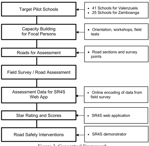
1.5 Conceptual Framework
The conceptual framework for this research is shown in Figure 3.
4
Figure 3. Conceptual Framework
The main concept in this study involves identification of the schools and roads for assessment. It is followed by a series of program information, workshops, orientation, as well as field tests. After successful data gathering and encoding, the rest is performed online by the SR4S system in obtaining star rating and scores.
2. REVIEW OF RELATED LITERATURE
According to a study by Ragland and Mitman (2007), pedestrian injuries at crosswalk locations represent a significant problem. Road crash along crosswalk resulted in pedestrian injury or fatality, and about one-third resulted to severe or fatal injury. These might be avoided by employing strategic safety guidelines through Engineering, Education and Enforcement.
Zeeger and Bushell (2010) also mentioned in their study that pedestrians are most at risk in urban areas due in part to the large amount of pedestrian and vehicle activities.
Furthermore, global death rates related to road traffic injury have continued to rise over the years, whereby various studies recommended promotion of initiatives to improve children’s safety and their learnings on road safety in general.
This paper on Child Road Traffic Injury Prevention focuses on school children. Engineering and Education played a major role in determining and improving Star Rating for Schools.
Target Pilot Schools
Capacity Building for Focal Persons
Roads for Assessment
Field Survey / Road Assessment
Assessment Data for SR4S Web App
Star Rating and Scores
Road Safety Interventions
• 41 Schools for Valenzuela
• 25 Schools for Zamboanga
• Orientation, workshops, field tests
• Road sections and survey points
• Online encoding of data from field survey
• SR4S web application
• SR4S demonstrator
5
3. METHODOLOGY
3.1 Star Rating for Schools (SR4S)
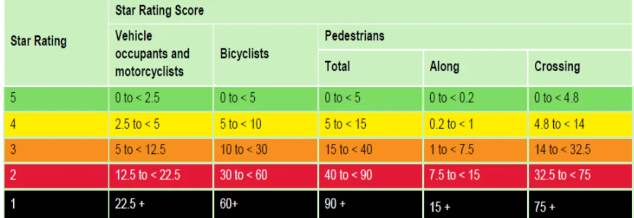
The Star Ratings System (SRS) and Star Ratings for Schools (SR4S) are system tools developed by the International Road Assessment Programme (iRAP), a charity dedicated to saving lives and preventing serious injuries on the world’s roads. The SRS is a simple and objective measure of the level of safety which is ‘built-in’ to the road. Target road users are vehicle occupants, motorcyclists, bicyclists and pedestrians. A rating of ‘5–stars’ correspond to the lowest risk while ‘1 – star’ corresponds to the highest risk for each road user type. Consequently, SR4S is dubbed as the “fiarst ever evidence-based tool” for measuring, managing and communicating the risk children are exposed to during their journeys and while they are within the premises of their schools.
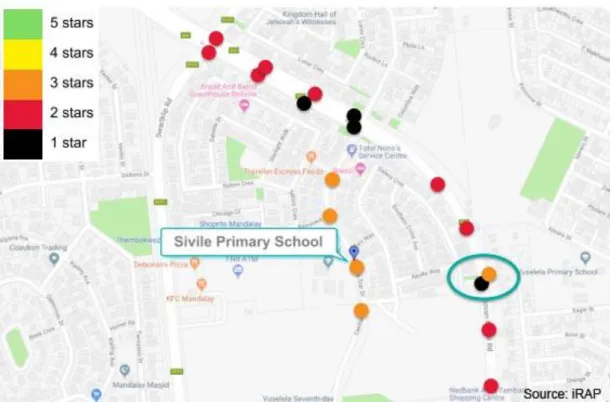
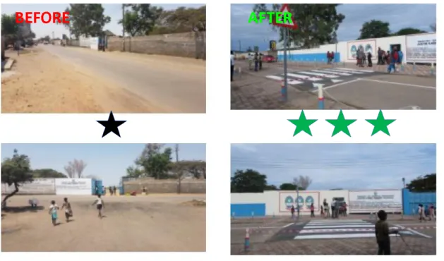
Figure 4 shows an example map showing the star ratings for selected locations (i.e., critical locations) around a school. Figure 5 shows the range of scores and corresponding colors for star ratings according to the type of road user. Figure 6 shows examples of “before” and
“after” interventions star ratings for a school.
Figure 4. Example map showing star ratings along roads for pedestrians
6
Figure 5. Star rating range of scores and colors for various road users
The figure below shows the formula that is operating behind Star Rating Scores web application.
Source: iRap
Figure 6. Star Rating Scores Formula
Figure 7 shows the typical example of the “before” and “after” interventions star ratings for a school.
7
Figure 7. Example of “before” and “after” interventions star ratings for a school
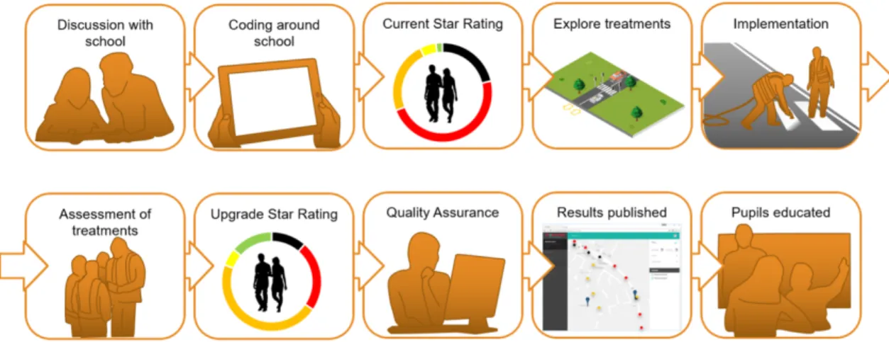
The following Figure 8 illustrates the SR4S process, which involves several stages including discussions with the schools, data collection through surveys around the schools, obtaining the star rating, identifying interventions (i.e., treatments), implementation of interventions, post assessment of treatments and updating/upgrading of star ratings. These ratings are validated through a quality assurance system done by an iRAP team. Published results are used to educate children, as well as other stakeholders about road safety in general and other particular issues pertaining to the schools under assessment.
Source: iRap
Figure 8. The SR4S Process 4. DATA COLLECTION
4.1 Schools
8
The schools and cities in this study were already pre-determined by the project proponents, comprised by non-government organizations, with the collaboration of local government units.
Even then, necessary ocular inspections were still conducted to observe the actual traffic and pedestrian movements. This was followed by the identification of high-risk locations where survey has to be performed.
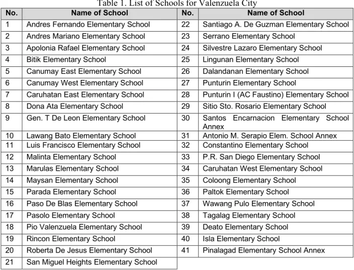
The involvement of non-government agencies and school officials as major stakeholders from the cities of Valenzuela and Zamboanga was established, so that achieving the objectives of the research will be easier. School engagement in particular is ensured to explain the study clearly and also to get their full support. The list of the schools for Valenzuela City is shown in Table 1.
Table 1. List of Schools for Valenzuela City
No. Name of School No. Name of School
1 Andres Fernando Elementary School 22 Santiago A. De Guzman Elementary School 2 Andres Mariano Elementary School 23 Serrano Elementary School
3 Apolonia Rafael Elementary School 24 Silvestre Lazaro Elementary School 4 Bitik Elementary School 25 Lingunan Elementary School 5 Canumay East Elementary School 26 Dalandanan Elementary School 6 Canumay West Elementary School 27 Punturin Elementary School
7 Caruhatan East Elementary School 28 Punturin I (AC Faustino) Elementary School 8 Dona Ata Elementary School 29 Sitio Sto. Rosario Elementary School 9 Gen. T De Leon Elementary School 30 Santos Encarnacion Elementary School
Annex
10 Lawang Bato Elementary School 31 Antonio M. Serapio Elem. School Annex 11 Luis Francisco Elementary School 32 Constantino Elementary School
12 Malinta Elementary School 33 P.R. San Diego Elementary School 13 Marulas Elementary School 34 Caruhatan West Elementary School 14 Maysan Elementary School 35 Coloong Elementary School 15 Parada Elementary School 36 Paltok Elementary School
16 Paso De Blas Elementary School 37 Wawang Pulo Elementary School 17 Pasolo Elementary School 38 Tagalag Elementary School 18 Pio Valenzuela Elementary School 39 Deato Elementary School 19 Rincon Elementary School 40 Isla Elementary School
20 Roberta De Jesus Elementary School 41 Pinalagad Elementary School Annex 21 San Miguel Heights Elementary School
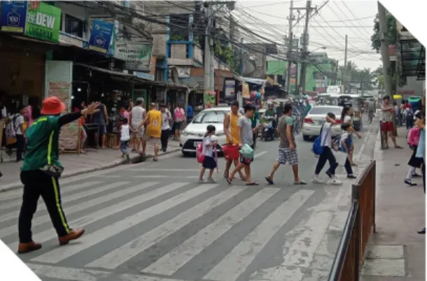
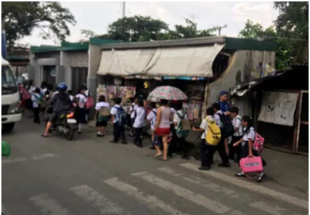
Following are photos showing the traffic situations and road attributes of some of the schools in Valenzuela City during the ocular survey.
9
Figure 9. Students walking along the road in the absence of sidewalks at Roberta de
Jesus Elementary School
Figure 10. Traffic supervisor and a marked pedestrian crossing at Gen. Tiburcio De
Leon Elementary School
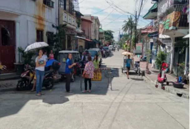
Figure 11. Road closure during class at at San Miguel Heights Elementary School
Figure 12. Dilapidated pedestian facility and poor road surface at Serrano
Elementary School School Table 2 shows the list of schools for Zamboanga City.
Table 2. List of Schools for Zamboanga City
No. Name of School No
. Name of School
1 Ayala Central School SPED Center 14 Sangali Elementary School 2 Recodo Elementary School 15 Culianan Learning Center 3 Maasin Elementary School 16 Divisoria Elementary School
4 Sinunuc Elementary School 17 Maria Clara Lorenzo Lobregat High School 5 Southcom Elementary School SPED Center 18 Putik Central School
6 San Jose Gusu Elementary School 19 Catalina Viuda De Jalon Memorial School 7 Baliwasan Central School SPED Center 20 Tetuan Central School
8 Sta. Maria Central School and SPED Center
(Gov. Ramos) 21 Mampang Elementary School
9 Immaculate Conception Elementary School 22 Talon-Talon Central School 10 Zamboanga Central and SPED Center 23 Don GEMS Elementary School 11 Southern City Colleges - WEST CAMPUS 24 Sta Barbara Elementary School 12 Southcom National High School 25 Zamboanga City High School Main 13 Zamboanga City National High School - West
10
The photos below show the traffic situations and road attributes of some of the schools in Zamboanga City during the ocular visitation.
Figure 13. Wide sidewalk and pedestrian waiting shed at Zamboanga Central School
Sped Center
Figure 14. Pedestrian facility at Zamboanga City High School West
Figure 15. Sidewalk along Sta. Barbara
Elementary School Figure 16. Typical road signs in front of Sangali Elementary School
Capacity building for the focal persons and some senior students from certain schools in Valenzeula and Zamboanga was undertaken in order to form survey teams for the necessary data collection. Such teams are, herein also referred to as “assessors” since they also need to assess the road and traffic attributes before coding them into the field survey forms accordingly.
The SR4S Surveys were conducted during the morning and afternoon peak hours of each of the 66 schools mentioned in the background section. Basically, peak hours are specific hours in the morning and afternoon where students are entering and leaving the school, during the first period and dismissal, respectively. Figures 17 to 19 show the location of the surveyed and assessed schools.
11 Source: Google Earth
Figure 17. Locations of the twenty-five (25) identified schools (in map) for Valenzuela City
Source: Google Earth
Figure 18. Locations of the sixteen (16) identified schools (in map) for Valenzuela City
12 Source: Google Earth
Figure 19. Locations of the twenty-five (25) identified schools (in map) for Zamboanga City Coding sheet and coding guide were given to the assessors for the data gathering. The group of attributes collected are as follows:
1) Road environment 2) Road type
3) Road features 4) School zone 5) Sidewalks
6) Pedestrian crossing 7) Pedestrian crossing type 8) Flow
9) Intersections 10) Intersection details 11) Curve
12) Curve details 13) Speed
4.2 Data Treatment and Encoding
Data collected by the trained assessors were treated for consistency with respect to the required inputs. This is followed by data encoding into the Star Rating for Schools web application.
After series of questions and email exchanges with iRAP assessors, Star Rating and Scores were generated accordingly. These are viewable online via the SR4S web panel.
The road safety interventions were generated using the system’s demonstrator feature, where a system user can explore potential measures to improve a school’s star rating and score.
This is crucial as this will be sent to the school and its governing local government unit in the form of a set of recommendations.
13
5. RESULTS AND DISCUSSION 5.1 Outcomes for Valenzuela City
Out of the forty-six (46) survey points assessed, 86.9% got a Star Rating of 5, while 10.9% and 2.2% got 4 and 3 stars respectively. It must be noted that most of schools surveyed are located in exclusive areas – some are within subdivisions zones, while others are within the midst of residences where accesses are generally narrow roads that can be hardly penetrated by four- wheeled vehicles.
Schools such as Andres Fernando, Canumay West, Lawang Bato, and Malinta Elementary and Coloong Elementary have more than one (1) critical data points identified for star rating assessment, hence two (2) star ratings for each of them. Table 3 summarizes the Star Rating Scores (SRS) and Star Ratings (SR) of the forty-one (41) selected schools in Valenzuela.
Table 3. Star Ratings and Scores of the 41 Schools in Valenzuela
No. Name of School Star Rating Score
(Pedestrian)* Star Rating*
1a Andres Fernando Elementary School (MH del Pilar 1) 3.77 5 1b Andres Fernando Elementary School (MH del Pilar 2) 3.48 5
2 Andres Mariano Elementary School 1.78 5
3 Apolonia Rafael Elementary School 0.14 5
4 Bitik Elementary School 6.50 4
5 Canumay East Elementary School 0.96 5
6A Canumay West (Kaypandan Rd) 4.61 5
6B Canumay West (San Diego Rd) 1.50 5
7 Caruhatan East Elementary School 1.13 5
8 Dona Ata Elementary School 0.45 5
9 Gen. T De Leon Elementary School 1.40 5
10A Lawang Bato 1 (Centro Gate) 9.67 4
10B Lawang Bato 2 (Exit gate) 8.70 4
11 Luis Francisco Elementary School 0.73 5
12A Malinta Elementary School (A De Castro St.) 1.38 5
12B Malinta Elementary School (A Pablo St.) 0.22 5
13 Marulas Elem School (Pio Valenzuela St.) 0.02 5
14 Maysan Elem School (102 Maysan Rd) 6.00 4
15 Parada Elem School (Parada Rd) 1.44 3
16 Paso De Blas (P. Santiago St.) 4.44 5
17 Pasolo Elementary School (Pasolo Rd) 0.56 5
18 Pio Valenzuela Elem School 4.01 5
19 Rincon Elementary School 0.14 5
20 Roberta De Jesus Elementary School 3.95 5
21 San Miguel Heights Elementary School 1.41 5
22 Santiago A. De Guzman Elementary School 2.42 5
23 Serrano Elementary School 0.43 5
24 Silvestre Lazaro Elementary School 1.37 5
25 Lingunan Elementary School (P. Gregorio St.) 4.48 5
14
No. Name of School Star Rating Score
(Pedestrian)* Star Rating*
26 Dalandanan Elementary School 0.20 5
27 Punturin Elementary School 2.96 5
28 Punturin I (AC Faustino) Elementary School 1.40 5
29 Sitio Sto. Rosario Elementary School 4.21 5
30 Santos Encarnacion Elementary School Annex 0.27 5
31 Antonio M. Serapio Elem. School Annex 2.65 5
32 Constantino Elementary School 7.74 4
33 P.R. San Diego Elementary School 0.52 5
34 Caruhatan West Elementary School 0.44 5
35a Coloong Elementary School (Coloong 1 Rd) 1.61 5
35b Coloong Elementary School (Batong Bakal St) 2.23 5
36 Paltok Elementary School 0.47 5
37 Wawang Pulo Elementary School 0.09 5
38 Tagalag Elementary School 1.07 5
39 Deato Elementary School 0.54 5
40 Isla Elementary School 0.89 5
41 Pinalagad Elementary School Annex 1.78 5
The following figures show examples of road assessment outcomes (Figures 20 to 22) and safety interventions (Figure 23) for selected schools in Valenzuela, using the SR4S web application.
Figure 20. SR4S outcomes for Parada Elementary School – before intervention
15
Figure 21. SR4S outcomes for Pasolo Elementary School – before intervention
Figure 22. SR4S outcomes for Marulas Elementary School – before intervention
Figure 23. Recommended interventions for the 3 schools in Valenzuela City
16
With the SR4S outcomes on hand and through the use of the system's demonstrator feature, a user can conveniently tweak the road or survey areas attributes in determining the optimum interventions and Star Rating and Scores.
In the case of Parada, Pasolo, and Marulas elementary schools, it appears that they would need the following interventions to achieve a 5-Star Rating:
Table 4. Recommended interventions to achieve 5-Star Rating
Intervention School
Parada Pasolo Marulas
Speed management x x x
Provision of crossing facility x
Improved crossing quality x
Put up school warning signs x x x
Provision of pedestrian fence x
Provision of crossing supervisor x
Put up road delineations x
5.2 Outcomes for Zamboanga City
Out of the twenty-six (26) survey points assessed, more than 40% got a Star Rating of 5, while 30% and 7% got 4 and 3 stars respectively. Others got 2 (7.7%) and 1 (11%) star ratings respectively. Majority of the schools surveyed are located along National Highways and primary roads where there are generally wider roads and vehicles are at a high speed.
Zamboanga Central and SPED Center school has more than one (1) critical data points identified for star rating assessment; hence two (2) star ratings are generated. Table 5 summarizes the Star Rating Scores (SRS) and Star Ratings (SR) of the twenty-five (25) selected schools in Zamboanga City.
Table 5. Star Ratings and Scores of the 25 Schools in Zamboanga City
No. Name of School Star Rating Score
(Pedestrian)* Star Rating*
1 Ayala Central School SPED Center 12.08 4
2 Recodo Elementary School 12.07 4
3 Maasin Elementary School 21.57 3
4 Sinunuc Elementary School 2.55 5
5 Southcom Elementary School SPED Center 4.03 5
6 San Jose Gusu Elementary School 5.62 4
7 Baliwasan Central School SPED Center 12.40 4
8 Sta. Maria Central School and SPED Center (Gov.
Ramos) 0.73 5
9 Immaculate Conception Elementary School 112.51 1
10a Zamboanga Central and SPED Center (San Jose
Road) 4.17 5
10b Zamboanga Central and SPED Center (Carmen
Road) 1.77 5
11 Southern City Colleges - WEST CAMPUS 5.72 4
12 Southcom National High School 99.49 1
13 Zamboanga City National High School - West 880.40 1
17
No. Name of School Star Rating Score
(Pedestrian)* Star Rating*
14 Sangali Elementary School 4.30 5
15 Culianan Learning Center 1.00 5
16 Divisoria Elementary School 61.79 2
17 Maria Clara Lorenzo Lobregat High School 61.25 2
18 Putik Central School 1.61 5
19 Catalina Viuda De Jalon Memorial School 4.98 5
20 Tetuan Central School 4.80 5
21 Mampang Elementary School 7.11 4
22 Talon-Talon Central School 30.71 3
23 Don GEMS Elementary School 7.82 4
24 Sta Barbara Elementary School 0.56 5
25 Zamboanga City High School Main 12.67 4
The following figures show examples of road assessment outcomes (Figures 24 to 26) and safety interventions (Figure 27) for selected schools in Zamboanga, using the SR4S web application.
Figure 24. SR4S outcomes for Zamboanga City National High School West – before intervention
Figure 25. SR4S outcomes for Immaculate Conception Elementary School – before intervention
18
Figure 26. SR4S outcomes for Southcom National Highschool – before intervention
Figure 27. Recommended interventions for the 5 schools in Zamboanga City
In order for the schools, namely Zamboanga City National School West, Immaculate Conception Elementary School, and Southcom National High School improve to desirable Star Ratings and Scores, the recommended interventions in Table 6 have to be implemented.
Table 6. Recommended interventions to achieve desirable Star Rating
Intervention
School Zamboanga
City National School West
Immaculate Conception Elementary
School
Southcom National High School
Speed management x x x
Provision of pedestrian fence x x
Provision of crossing supervisor x x
Improve sight distance x
19
6. CONCLUSION 6.1 Summary of Findings
Following are the findings of this study:
• Most of the schools in Valenzuela got a 5-star rating. As discussed in the previous chapter, most of the schools are inside the subdivisions and residential areas. However, even with such considerably high star rating, there are still rooms for improvements, such as basic road markings, speed limit signs and the like;
• Quite a number of pilot schools in Zamboanga city registered low star ratings. This is mainly due to their location characteristics, where most are along the national highways;
• Operating speed is a major factor that affects star rating and score;
• Star rating for schools (SR4S) is an evidence-based tool that is able to show how children are at risk on the road and while on their journey to and from school;
• SR4S can show quick and easy measurement of safety at the schools, and can recommend appropriate treatment options;
• The results generated by the system can be effective as a communication tool to the stakeholders, especially the local government unit, to realize schools’ safety needs and requirements;
• Most of the schools in this study lack road crash / injury data involving their students.
6.2 Recommendations
Based on the outcomes of the assessments conducted, the following recommendations are made:
• Formalized Road Assessment Program for the Philippines (e.g PhilRAP) to enhance road assessment capacity of the local government units and other stakeholders to ensure continuity of the SR4S activities;
• Localized SR4S evaluation system (e.g., road attributes, etc.) to capture local road characteristics;
• Schools and Local Government Units should have a clear communication and understanding of their road safety targets and goals, specifically on the needed interventions. This is to facilitate easy program implementation;
• Institutionalize a program that seeks to enjoin schools to keep a road crash / injury data of their students. This will assist the schools and the local government units in planning and implementing road safety initiatives;
• Integrate pedestrian behavioral data in the road assessment. This will widen and strengthen the data for analysis and future road safety planning.
6.3 Further Studies
The project is still ongoing but the following further works are proposed:
• Post assessment of the pilot schools in Valenzuela and Zamboanga cities – to see changes in star rating and scores after implementation of the recommended interventions;
• Conduct SR4S surveys and assessment of the schools not included in the pilot study for
20
Valenzuela and Zamboanga cities;
• Future research on the effects of secondary road injury data and traffic data on the SR4S survey data;
• Evaluate schools informal pedestrian traffic management measures in Valenzuela and Zamboanga. While these are done with good intentions, some might not be in parallel with what the local government is doing. Such measures also have to be checked whether they comply with the legal standards of the local public works department.
ACKNOWLEDGEMENTS
The authors would like to acknowledge the United Nations Children’s Fund (UNICEF) for supporting this study. Acknowledgement is also extended towards Safekids Worldwide Philippines, Inc. and Human Development and Empowerment Services (HDES) for the administrative support and the Civil Engineering students of Pamantasan ng Lungsod ng Valenzuela (PLV) and Western Mindanao State University (WMSU) who did the data collection in Valenzuela City and Zamboanga City respectively.
REFERENCES
iRAP, Step by step process, https://www.starratingforschools.org/how-to
iRAP, Star Rating for Schools Coding Guide, https://www.starratingforschools.org iRAP, Star Rating Bands and Colours, https://www.starratingforschools.org
iRAP, Star Rating Scores, https://www.starratingforschools.org
Ragland, David R, Mitman, Meghan Fehig, (2007). Driver/Pedestrian Understanding and Behavior at Marked and Unmaarked Crosswalks
Resolutions, https://www.who.int/violence_injury_prevention/publications/resolutions/en/
Star Rating for School web application, https://results.starratingforschools.org/
World Health Organization (WHO), 2019 Top 10 causes of death in the Philippines for both sexes (5 to 9 years old), https://www.who.int/data/gho/data/themes/mortality-and-
global-health-estimates/ghe-leading-causes-of-death
World Health Organization, UN General Assembly and World Health Assembly
Zeeger, Cahrles V., Bushell Max, (2010). Pedestrian crash trends and potential countermeasures from around the world.
View publication stats