Geological field surveys of the Johnny Lyon Hills area were supported by the US Depository Branch. Many colleagues and friends of the geochemical laboratory have made other contributions to the work too long to enumerate. Responsibility for completing the study of Johnny Lyon Hills was given to the writer by Cooper in 1950.
In the summer of 1949, the writer joined the Little Dragoon Project to help map the Johnny Lyon Hills area. In 1950, in J's absence, the writer was put in charge of the field party on the project. In addition to the author's work, contributions to field mapping were made during the SUJIIIIer of 1949 by Cooper, by A.
The Johnny Lyon Hills are located on the western edge of the Dragoon qJ.adrangle in northwestern Cochise County, Arizona (e.g. See also plate V, a topographic map of the Happy Valley q1 adrangle, adjacent to the Dragoon Quadrangle in the west.) .
PLATE III
GENERAL MAP OF ARIZONA
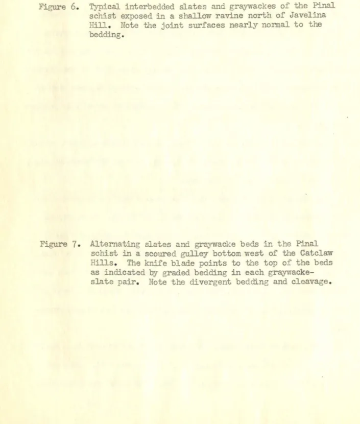
Javelina Hill and Lechugilla Hill are prominent in the southeastern part of the map area. Alternating shale and greywacke beds in Pinal shale in a scoured sewer bed west of the Catclaw Hills. Graywacke in the upper part of the Pinal shale section, recording the characteristic sedimentary textures, despite evidence of same.
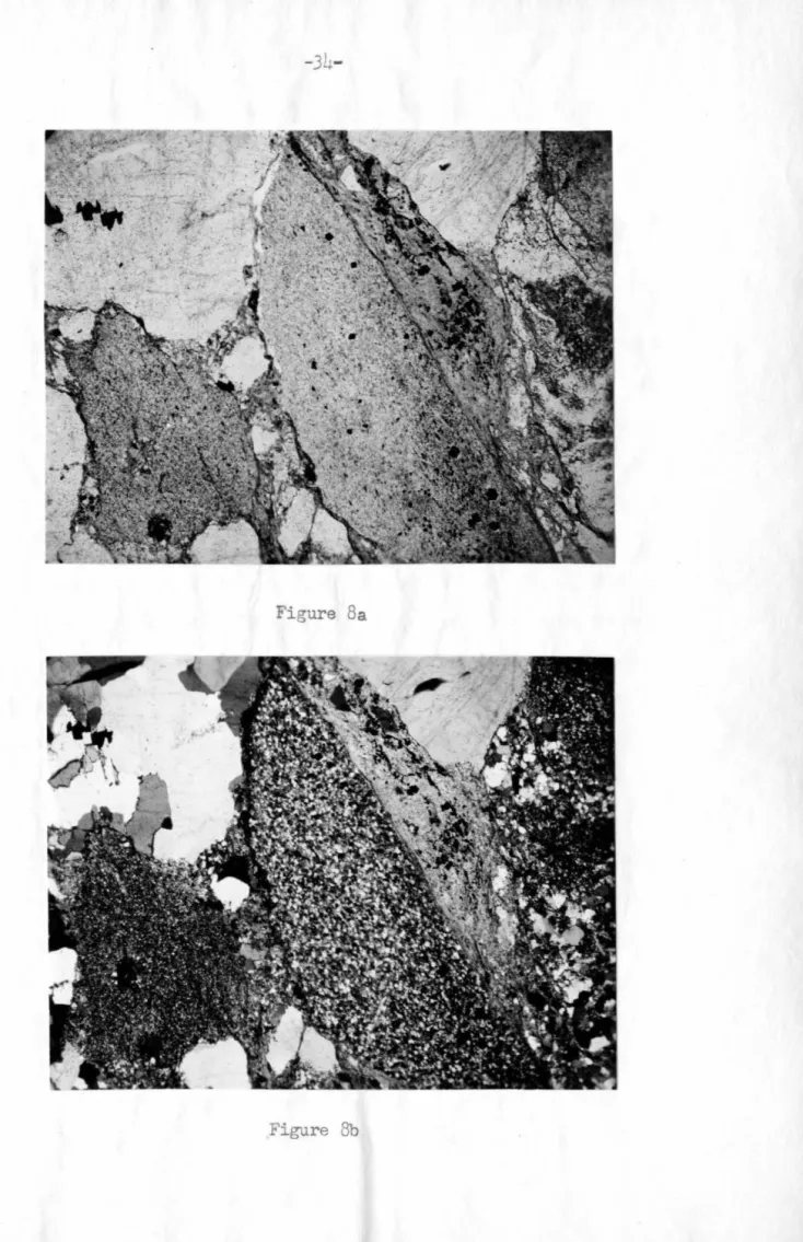
Typical grajli7acke in the lower part of the Pinal schist section, with essentially original sedimentary texture. Due to the variability in the feldspar content of the sandstones of the Pinal schist, no further subdivision has been applied. They are preserved by being subsumed by part of the Pinal shale section that is no longer visible in the Johnny Lyon Hills.
This 'Wi 11' will be discussed further in the section on pinal slate structure. Laminated hornfels in pinal shale, thirty feet from the intrusive contact of the Johnny Llfon granodiorite. This divergence occurs only on the southeast side of the Pinal fault belt in the area.
Equal-area net plot of mean line positions at 230 localities in the Pinal Shale along the Johnny Lyon Hills.
GENERALIZED MAP OF THE
JOHNNY LYON HILLS
SCALE IN MILES
All the stripped blocks (I, III, IV, V) of the Pinal shale share many features in ccmmon. Each has a thick section of beds on the northwest side of the block, ranging from more than 9,000 feet in Block I to 2,500 feet in Block IV, where the sedimentary structures and textures are well preserved. This argument cannot be applied to some of the other turning points, but nevertheless the predominant condition of overturned beds with peaks to the northwest is clear.
The general parallelism of the schistosity and bedding characteristic of most of the schists makes a gradual transition to a systematic divergence as either block is traversed in a southeasterly direction. The divergence does not become impressive until a point is reached 1,000 to 1,500 feet southeast of the edge of the rhyolite-porphyry sheet zone, in most of the schist exposures southwest of Keith Peak. Since even this section has graded beds with tops to the northwest prevailing, the reversals in graded bedding are often the first field indication of the fold.
Cleavage is generally in the axial plane, but usually shows a slight radiating pattern in the ridges of the folds. Their connection to the flow associated with the isoclinal folding of beds with alternating and contrasting ability is clear. Any attempt to integrate the various blocks into a pre-Laramide structural pattern is limited by the fact that most of the inter-.
The general directions of the thrusts and an idea of minimum displacements can be deduced from several lines of evidence, but these are insufficient for accurate reconstruction. The Laramide effects contributed to an apparent lateral shortening of the pre-Cambrian section in the direction of the pre-Cambrian structural trend. Some indication of the deviations from parallelism to this direction can be obtained from the apparent deviation of such features as the intrusive contact, and the rhyolite porphyry and mica rhyolite zones.
One possible interpretation of the Pinale structure (which involves considerable extrapolation) places i t within a limb and part of the core of a major anticlinal fold. The axis of the major fold is assumed to be conformable 'With that of its subordinate folds and therefore dips steeply to the southwest. The northeastern end of the Pinal thrust belt in the Johnny Lyon Hills tile is truncated by the Pre-Cambrian unconformity at the base of the Apache Group.
N SCALE
The structural trends of the pinal shale in their true pre-cambrian orientation, it is necessary to carry out a reconstruction which eliminates. The size of the block that must be rotated to include the entire shale is greater than 6 miles in a northeast-southwest direction. It should be noted however that the required NE-SW dimension of the rolled block is of no greater magnitude than that demonstrable in a horizontal direction.
If such a large block was rotated, the implication is that the southwestern end of the belt was once buried kilometers deeper than the northeastern end. Stereographic solution for restoring the general foliation and lineation in the Pinale schist to its pre-Apache group orientation. The general 1. deformation of the rank of metamorphosis throughout the belt does not confirm this.
Pinal shale-dominant shale and bedding in the Johnny Lyon Hills is consistent with the Little Dragoon Mountains and the attitudes of the shale throughout southeastern Arizona. Cooper and others represent the first detailed studies of the older Pre-Cambrian shales of southeastern Arizona. The widespread exposure of older Pre-Cambrian rocks in the two areas (figs. and the relatively low grade of metamorphism in large parts of these areas, meant that great progress had to be made in understanding the origin and complexity of the formation.
Ransoroo's early conclusions regarding the sedimentary origin (1903, p. 26) of the schists and quartzites that formed the great Ep-Archaean erosional surface in southern Arizona have been confirmed. His speculations on the basic extrusive origin of some of the associated amphibolite schists have also been confirmed.
DISTRIBUTION OF
OLDER PRE-CAMBRIAN ROCK DRAGOON QUADRANGLE
UTTLE DRAGOO'J MTNS
A sample from the interior of a greenstone body with clear evidence of silicification shows a 75% increase in Na2O content. Regarding the Alder Creek series, the other two members of the series are to blame. Major metasedimentary components have been recognized in the Vishnu Shale of the Grand Canyon (Noble and Hunter, 1917; . Campbell and Maxson, 1933).
The granodiorite there is obliquely unconformable to the structure of the Pinale schist into which it is intruded. Numerous fissure inclusions in the marginal areas of the granodiorite only have their internal structure parallel to that of the wall rock. Coarse textured granodiorite is immediately adjacent to the contact hornfels phase of the Pinale schist.
Further north, near the Aroorican mine, major displacements contain a block of schist intruded on granodiorite. No specimens of granodiorite have been observed that are completely free of so-called alteration minerals. The metamorphic character of these inclusions has already been discussed in the section on contact metamorphism of the Pinal schist.
The inclusion on the right shows clear original foliation in the orientation of the aggregates of dark hornblende. Most of the inclusions of amphibolite further modified the composition and texture of the granodiorite. The texture of the quartz phenocrysts suggests the resorption forms seen in the rhyolites in the Pinale schist.
Some excellent examples are seen in the contact zone of the Pinal shale northwest of Javelina Hill. Located near the vmstern band is a series of crosscutting veins of brown carbonate, quartz and limonite casework. They are also identical in mineralogy to some of the mineralized rocks of the post-Paleozoic fault zones.
One of the widest compression zones evidently associated with thrusting is exposed at.N~i, sec.