ATOLL RESEARCH BULLETIN NO. 460
ATOLLS AS SETTLEMENT LANDSCAPES:
UJAE, MARSHALL ISLANDS
BY
MARSHALL I. WEISLER
ISSUED BY
NATIONAL MUSEIJM OF NATURAL HISTORY SMITHSONIAN INSTITUTION
WASHINGTON, D.C., U.S.A.
AUGUST 1999
Q
Eny'am'eg BiginnigarErlie
0
U j a e
P a c i f i c
M A R S H A L L I S L A N D S
Namdb.
. v""
M,,# QX,,h
0
Bikku
9
0 Rua A t o l l
0 Langeba
FIGURE 1. Ujae Atoll and archaeological sites with map of the Marshall Islands showing location o f Ujae. Atolls i n bold (Utrok, Maloelap and Ebon), situated along t h e continuum o f rainfall from the d y north t o the wet south, are part o f the Long-term archaeological study o f the Marshall Islands.
ATOLLS AS SETTLEMENT LANDSCAPES:
UJAE, MARSHALL ISLANDS
BY
MARSHALL I. WEISLER'
ABSTRACT
Williamson and Sabath (1982) have demonstrated a significant relationship between modern population size and environment by examining atoll area and rainfall in the Marshall Islands. The present work seeks to extend that argument into prehistory by examining the relationship of ancient habitation sites and size of aroid pit agricultural systems to atoll land area and rainfall regime along the 1,500-3,500 mm precipitation gradient in the Marshall Islands. Four atolls were selected for study: Ebon at the wettest extent in the extreme south;
Ujae and Maloelap near the center of the archipelago; and Utrc?k at the dry north. The first phase of this long-term archaeological program is reported. During the survey of Ujae Atoll (9" 05' N, 165" 40' E), three habitation sites, an aroid pit agricultural zone, one early historic burial, and seven fish traps, weirs, and enclosures were recorded. Along with excavations at two habitation sites (8 m2 total area), 35 traditional artifacts were recovered (shell adzes, ornaments, and manufacturing tools). Seven radiocarbon age determinations document land use beginning as early as the third century A.D. A beachrock sample dated to 2450 _+ 70 BP relates to atoll development. Some 4,748 bones of fish, birds, turtles, Pacific rats, lizards, humans, and possible cetaceans, along with nearly 13 kg of shellfish, provide the basis for understanding prehistoric subsistence, human adaptations to the atoll setting, and land use patterns.
INTRODUCTION
Pacific coral atolls are unquestionably the most precarious landscapes for settlement, yet many of them evidence continuous human occupation for 2,000 years. Unlike the high volcanic islands of the Pacific plate and the non-oceanic or continental land masses west of the Andesite Line, coral atolls are unique in their small size, low elevation, limited diversity of terrestrial flora and fauna, poorly developed soils, and an absence of surface potable water-all characteristics that would limit a sustained human presence. How did small human founding groups survive and, in a sense, flourish on these most challenging of Pa- cific landscapes? In 1993, a long-term interdisciplinary study of the archaeology and pre- 'Department of Anthropology, University of Otago, P. 0. Box 56, Dunedin, New Zealand.
Email: [email protected]
Manuscript received 9 October 1998; rcvised I April 1999
history of the Marshall Islands was initiated. Located about 4,000 k n ~ southwest of Hawai'i, the Marshalls are situated mostly between 4" - 12" north latitude and consist of 29 low coral atolls and five small islands oriented in two roughly parallel lines trending southeast-north- west for about 1,100 km. Selection of four atolls for intensive archaeological survey and excavations was based on the marked rainfall gradient beginning in the wet south, with about 3,500 mm of annual precipitation, to 1,500 mm in the dry north (Fig. 1). On Pacific atolls, rainfall is the most significant determinant of species diversity (Fosberg 1984; Stoddart 1992) and is mirrored in the prehistoric settlement patterns by varying densities of surface artifacts, area of prehistoric habitations, and size of agricultural systems. Williams and Sabath (1982), in their modern population studies, have demonstrated the close correspond- ence between human carrying capacity, island size, and climate. Consequently, Marshall Islands atolls were selected for study at opposite ends of the rainfall gradient beginning with the most southern one of Ebon (4" N latitude), Maloelap (8" 50') and Ujae (9") near the center of the archipelago, and UtrGk (I 1" 15'), one of the farthest north, permanently inhab- ited atolls.
Beginning about 2000 BP, human colonists of the Marshalls targeted the pristine stocks of fish, sea birds, turtles, and coconut crabs (Birgus latro), yet permanent settlers would ultimately depend on terrestrial production for the bulk of their subsistence. Aroid pit culti- vation for Giant swamp taro (Cyrtospernza chamissonis)-uniquely adapted to the harsh conditions of atolls (Thompson 1982; Weisler in press)-is the foundation of Marshall Islands culture. Pandanus, with numerous varieties cultivated throughout the Marshalls (Stone 1960), was the fundamental tree crop for the dry northern atolls, while breadfruit increased in importance towards the south. Arrowroot (Tacca leontopetaloides) was grown on all the atolls and supplemented the carbohydrate intake.
After a brief review of previous archaeological research in the Marshalls, results from the first archaeological survey and excavations from this long-term project are reported.
PREVIOUS ARCHAEOLOGICAL STUDIES
Archaeological research in the Marshall Islands began with the Kelton-Bishop Museum Expedition i n 1977, and continued with phases in 1979 and 1980. The first effort was a brief reconnaissance-level survey of 12 atolls and recording of 42 sites with the goal of determining if these atolls had sufficient, intact prehistoric cultural deposits warranting detailed study (Rosendahl 1987). More than 4,000 portable artifacts were collected and included shell adzes, fishing gear, scrapers, ornaments, and manufacturing tools such as shell hammerstones and pumice and coral abraders. Although not from dated contexts, this is an important archaeological collection of Marshall Islands artifacts. Eight habitation sites on four atolls were test excavated and one radiocarbon age determination established occu- pation by 1260 ir 80 BP (Rosendahl 1987:161).
While Rosendahl's survey was extensive, Rilcy, in 1979, focussed on a single atoll, completing an intensive survey and transect excavations of a major prehistoric village site.
He recorded 122 sites on Majuro Atoll which he classified into midden areas (sites with surface food remains), house platforms, coral-faced structures (some of which were his- toric burials, e.g., Riley [1987:fig. 2.4]), fishtraps, wells, and a Cyrtosperma pit zone. Fol-
lowing the observations made by the botanist Hatheway (1953), Riley suggested that the oldest portions of habitation sites should be in the middle of the islet. The greatest density of recorded sites was at Laura village, on the largest islet, and excavation conducted there produced a radiocarbon age determination of 1970 f 1 10 BP-one of the oldest habitation dates for the Marshalls.
The last phase of the Kelton-Bishop Expedition was a detailed survey of Arno Atoll with systematic transect excavations undertaken to locate buried prehistoric sites that may not have surface indications (Dye 1987). Some 133 islets were surveyed and 164 sites recorded, mostly habitations. The earliest human occupation was dated to about 1000 BP, while dates for the reef platform were 2,500-3,000 years old.
In the northern Marshalls, Streck surveyed and conducted test excavations on five atolls (1990). Brief excavations on Bikini Atoll yielded 35 radiocarbon age determinations, 15 percent of which were older than 2000 BP. Most were "grab" samples from eroded expo- sures of cultural layers and the stratigraphic details have not been published. Few archae- ologists accept the oldest dates because old drift logs may have been used for fuel (Kirch and Weisler 1994:292). That is, dating drift wood from trees with a long life span can add hundreds of years to radiocarbon age determinations. Consequently, the date when the log was used for fuel is increased by the age of the tree.
In conjunction with expansion of the airport on Kwajalein Atoll, Shun and Athens (1990;
see also Beardsley 1994) reported a buried gray layer on Kwajalein islet dated to about 2000 BP. Located near the center of the islet, the layer may represent a natural swamp or constructed aroid pit. Also on Kwajalein, Weisler er al. (in press) recovered a single human burial during construction of utility lines. Found with 151 grave goods, the bones probably are those of an individual of relatively high status who may have shared communication or trade links with groups on nearby Polynesian islands. Ancestral ties with the Marianas are suggested by a comparison of ancient mtDNA.
Widdicombe recently completed a technological study of Marshallese shell adzes from Ebon, Maloelap, and Ujae atolls (1997). Adzes were manufactured from large and small taxa of Tridacna, helmet shells (Cassidae), conches (Lambis sp.), and less frequently from cones (Conidae) and augers (Terebra sp.). No significant differences were noted in terms of assemblage composition between Maloelap and Ebon yet, today, residents of the largest islet of Kaven, Maloelap Atoll, say that ?: gigas does not grow there-perhaps because of the deep offshore lagoon waters. Consequently, I: gigas adzes may have been imported.
Somerville-Ryan (1998) has reported on a taphonomic investigation of archaeological shell- fish assemblages from Ebon Atoll. During prehistory, shellfish were brought to sites as food, as raw material for tool and ornament manufacture, and in water-rolled coral gravel used for pavement. His study suggests that only a few taxa reliably reflect food use, and archaeologists should be aware of this when selecting specimens for radiocarbon dating.
The past two decades produced at least brief archaeological surveys on nearly half of the Marshall Islands, and a range of prehistoric artifacts and habitation sites have been documented. Detailed excavations are, as yet, rare, but widely accepted radiocarbon dates establish human occupation by about 2000 BP.
ARCHAEOLOGICAL SURVEY OF UJAE ATOLL Introduction and Objectives
The main focus of the archaeological study was the survey of Ujae islet and subsequent transect excavations for defining the site boundaries-at least the ocean to lagoon extent.
This was done for three reasons: (1) the most substantial and oldest village is normally located on the largest islet of an atoll; (2) the entire population of the atoll now lives on Ujae islet, which facilitated the work and made best use of the limited time; and (3) the archaeo- logical study was also undertaken as part of a historic preservation training program and, by conducting most work in the village, it was easier to interact with school children and other members of the community who visited the on-going excavations. In my former capacity as Chief Archaeologist for the Republic of the Marshall Islands, I found that it is much easier to teach historic preservation by involving residents directly in archaeological survey and excavations, than by lecturing about abstract concepts in the village schoolhouse.
Located near the center of the archipelago in the Ralik chain of the Marshalls, Ujae Atoll (9" 05' N, 165" 40' E)-ranks 22 in land area amongst the group--consists of 12 larger islets (with a total land area of 1.8 km2) which surround a 180 km2 lagoon (Bryan
1971). The largest islet, named for the atoll, contains the entire population of 488 people (Office of Planning and Statistics 1988). Some 81% of households are involved in copra production and credit is issued for kerosene, rice, floul; sugar, and cooking oil. It is a sub- sistence lifestyle with nearly all of the people engaged in growing food and fishing. In 1988, firewood was the dominant source of cooking fuel, but less so in 1994 after several years of U. S. Federal food assistance.
Only one diesel boat was operating at the time of our visit and it was rented for $US251 day including two operators. The archaeological survey began after we left Ujae islet mid- morning on 4 July 1994 traveling within the lagoon up the windward side stopping at Langeba, Wotya, bypassing Rua, and spending the night at Ebbetyu (Fig. 1). Leaving Ebbetyu the following morning, we bypassed the small islets of Bikku and Erlie and had to wait several hours for high tide before approaching Enylamieg. We only spent a short time there to enable us to reach Bokerok with sufficient time to set up camp before dark. Bokerok supports a dense colony of nesting noddies and I saw it as a good opportunity to record how the Ujae Marshallese capture, butcher, and cook birds, and to document the fracture and burning characteristics these activities have on the bones (see Weisler and Gargett 1993) as well as the spatial patterns resulting from discard. This ethnoarchaeological study was of value for interpreting bird bones recovered from the excavations on Ujae and elsewhere.
We spent two nights on Bokerok before going to Bock where we stayed an additional two nights while excavating a midden site. We returned to Ujae by mid-day on the 9th. The results of the survey are presented below by islet, beginning with Ujae and following coun- ter-clockwise around the lagoon.
Islet Survey
Ujae Islet (0.47 km2). This is the largest islet of the atoll and the one suspected of having the biggest and oldest village. The center of the islet has numerous elongate and sinuous Cyrtosperma pits which today are mostly abandoned. Breadfruit, banana, papaya, and
FIGURE 2. Aerial view of Ujae taken 17 February 1944 before construction of the Landing strip now located along the southern half of the islet. The modern village paths are clearly visible just inland of the Lagoon shore. Note the extensive reef flats that cover most of this frame. (Courtesy of Bernice P. Bishop Museum, negative No. CP 117,087, composite of
# I 1 6 and #117, AP28A-VD3.)
Pandanus trees are maintained in the modern village which is located within the northern third of the islet. In Figure 2, an aerial photograph taken 17 February 1944, the main village paths form an obtuse triangle just inland from the lagoon shore near the middle of the coast, with one leg of the polygon extending to the northwest point. The first step in the archaeo- logical survey of Ujae islet was to walk around the modern village and observe the stratigraphy in trash pits and foundations dug for new houses. This was an expedient way of gaining a general indication of the depth and location of prehistoric deposits. In gardening areas with clear ground visibility, large, fragmented shellfish (such as Tridacna andLambis) were observed and a few shell adzes collected. Several transects walked through the inte- rior established that the ancient village (designated site 1) was located lagoonward of the Cyrtosperma pits. Seven 1 m2 units were excavated along a transect beginning near the center of the islet to just above the lagoon shore; an additional unit was excavated 250 m east of the main transect. Thelagoon-ocean side transect established that thesite was420m wide (north-south) and a conservative estimate (based on the distribution of surface arti- facts and cultural layers seen in modern trash pits) suggest a site length of ca. 600 m along the lagoon shore axis. A site area of 25 hectares seems reasonable.
On the reef flat off the west coast, six stone configurations, presumably fish traps, weirs, and enclosures, were located. No Ujae residents knew anything about these features since they probably went out of use decades before; these features are described below.
Larzgeba Islet (0.06 km2). This is the first islet north of Ujae along the east or windward margin of the atoll. No archaeological sites were located on this islet as it is small with numerous wind-fallen trees, and wave-deposited rnbbish+vidence of wash-overs. There are less than 100 coconut trees on the islet, with typical coastal vegetation such as Toumefortia and Scaevola. Coconut crabs were collected from the bases of a few large Pisonia grandis trees in the interior of the islet. A large exposure of beachrock was noted along southeast coast. The gravelly interior and small islet size does not support a fresh water lens. Coconut crabs found today, in addition to nesting seabirds in previous times, would have been the dominant food resources and the main reasons for visiting the islet.
Wotya Islet (0.16 kmz). Nearly in the center of the east coast of the atoll, Wotya may be large enough to support a fresh water lens which is suggested by the modern habitation area. Turtle nests were observed on the ocean side, north shore. Arrowroot was seen grow- ing in the interior and large Pisonia trees that cover the south quarter of the islet support nesting noddies (Anous spp.). The presence of the small tree, Neisosperma sp. (Ochrosia sp.), in the islet interior, suggested to Fosberg (1955:21) that storm waves occasionally reached inland areas, dispersing seeds of this plant, which otherwise should not have been found growing away from the shoreline. A prehistoric midden (site 2) was located along the lagoon side west shore immediately above an area of beachrock. The shoreline is eroded here, forming a wave-cut bank ca. 1.25 m high exposing a dark midden layer ca. 0.5 m thick consisting of Tridacna and Lambis shellfish, coral oven stones, and one earth oven, the base of which was 1.10 m below surface. The site runs about 75 m along the shoreline, while its inland extent can only he determined by excavation. However, it is probably less than 0.5 hectare. Numerous Tridacna valves inland of the exposure may be from the modern settle- ment.
Rua Islet (0.08 kin2). We sailed slowly past this islet and due to its small size, low eleva- tion, and sparse vegetation, its was unlikely to have prehistoric cultural deposits.
Ebbetyu Islet (0.22 kin2). We arrived at this islet after 5 pm and could only spend a short time surveying before dark. Turtle tracks were noted on the northwest point on the ocean side. Two modern, abandoned houses were located just inland of the south shore on the lagoon side. The most southeast house had three large breadfruit trees and a well about 50 m inland from a coral pavement. The islet size suggests a prehistoric site should be present, but excavation would be necessary to locate buried deposits. Compounding the problem of identifying prehistoric cultural material on the ground surface is the presence of large shell- fish that may only be refuse from the modern occupants; this is especially true of histori- cally-discarded shellfish that have been bleaching in the sun for many decades and, conse- quently, can be confused with prehistoric midden. Fosberg noted, in February 1952, a layer of pumice pebbles covering a few square yards of Anuij, the islet south and connected to Ebbetyu (Fosberg 1955:20). Pumice is used occasionally today to sharpen tools and would have been an important resource in prehistory.
Bikku Islet (0.09 kin2). We did not have time to stop at this islet but, as we sailed by, it was clear from its small size, rocky topography, and sparse vegetation that no prehistoric cul- tural deposits would be present.
Erlie Islet (0.06 km2). One of the smallest of the islets, time limits did not permit stopping at this locale but, similar to the environmental constraints observed on Bikku, no prehis- toric cultural deposits could be expected. Fosberg reported a pure Cordia forest which he considered a rare occurrence in the Marshalls (1955:22). He mentioned an "enormous number of hermit crabs" which, today, are the preferred bait for bottom fishing for the lethrinid Moizotwlis grandoculis (personal observation on Utr6k Atoll, 1996-7).
Biginnigar Islet (0.07 knt2). This small shoal could not have supported prehistoric cultural deposits. Residents mentioned that Golden cowries (Cypraea aurantium) are occasionally collected on the adjacent reef flats.
Enylamieg Islet (0.44 km2j. This islet must be approached at high tide to affect a landing.
Unfortunately, we arrived at low tide and wasted precious time walking across the broad reef flat. Arriving at the southern tip of the islet, we walked inland about one-half of the way, noting a village (abandoned perhaps a few generations ago) marked by beachrock slab-lined paths near the west coast. Because this islet is no longer used for habitation, it is densely overgrown and ground visibility was negligible. No prehistoric sites or features were observed, but islet size and presence of the historic village suggests that an ancient site must surely exist.
Bock Islet (0.09 km2). On the leeward side of Ujae Atoll, just north of the main channel to the lagoon, Bock islet has a dense, black, prehistoric midden located just above a beachrock formation on the lagoon shore. Fosberg and colleagues established an astronomical station on Bock for several days in early 1952. On the south end of the islet, large Pisonia trees reached heights of 30 m-a fact remarked by Fosberg in 1952 (1955: 19). He also recorded
large individuals of intsia, at least 25 m in height, which, in Hawai'i, is normally a6'small to medium-sized tree" (Neal 1965:418). The economically important Morinda citrifolia (nen) was recorded in several places along an elevation transect. The temporary encampment, noted by Fosberg some 30 years before, was still in use in 1994; and the Marshallese are still coming to Bock to capture the plentiful noddies. A partially submerged beachrock
"island" is the best marker for the prehistoric site, where, beginning just above the beach and immediately west of the site, a trail leads inland to a modern sleeping house, cook shed, and well. The inland extent of the midden is clearly delimited by a wet swale less than 10 m distant from a lo.# mound, while the site measures 135 m east along the lagoon shore (see Figs 1 and 3). Assuming a width of ca. 15 m, the site is about 2,025 m2 (or 115th hectare).
Unlike the largest islets of most atolls, this smaller landmass does not have a central depres- sion where Cyrtosperma pits are usually found. On Bock, the islet rises gradually from the lagoon shore before descending to the cobble ridge and beachrock on the ocean side (Fig.
3). We stayed on the islet a day and a half completing an elevation transect and a 1 m2 excavation unit, described below.
Bock Islet, Site 3 Elevation transect
FIGURE 3. Transect through site 3, Bock Island.
Bokerok Islet (<0.05 km2). This small islet does not have prehistoric cultural deposits but, at least today, is a significant nesting area for noddies. On the lagoon side there is a small camp used for a few days at a time while capturing noddies. The site lies about 4 m inland of the vegetation line and consists of a level area (9 m2) used for sleeping as well as process- ing and roasting birds. A fire pit, used for roasting and not baking birds, is situated near the level area and about 1 m away is a dense concentration of wing bones where these non- edible portions of birds were routinely discarded. Elements containing high meat portions were tossed around the perimeter of the sleeping area after roasting and consumption (Fig.
4). Two historic burials were found inland, one was mapped and consisted of a rectangular perimeter of beachrock slabs, only two remaining in the original upright position (Fig. 5).
These are typical historic burials as described by Finsch during his visit to the Marshalls in the 1870's (Finsch 1893).
3okerok Islet
Jjae Atoll
t
beach Ern
_---
___C____-
_ _ - - - - _ _ _ C - - -e d g e o t v e g e t a t i o n
-
,'
dense wing bones
I
Approximate
@ tree
FIGURE 4. Modern bird processing camp, Bokerok islet.
Bokerok Islet, Site 4, Historic Burial
[3 Fallen beachrocksiab
FIGURE 5. Historic burial, site 4, Bock islet.
Site Classes
Habitation Sites. The common habitation site was a midden recognized on the surface by scattered and fragmented large shellfish (such as Tridacna and Lanzbis), coral and beachrock oven stones, and shell adzes. Earth ovens are commonly used on the outer atolls (not Majuro or Kwajalein) and shellfish are still eaten today. Consequently, it is not always possible to differentiate old, bleached, and weathered food shells that are, say 100 years old, from prehistoric specimens. Therefore, the presence of shell adzes was the best criterion to iden- tify a prehistoric habitation site, especially in reference to topographic setting and proxim- ity to aroid pits. Buried prehistoric cultural deposits were recognized by dark, sandy sedi- ment, earth ovens, and dispersed charcoal, oven stones, shell artifacts, shellfish, and bone midden. Cultural deposits were found exposed at the lagoon shoreline near beachrock (e.g., site 2) or seen in the walls of trash pits and other recent excavations. There has been a tendency by some archaeologists to designate a new site for each seemingly isolated sur- face scatter of artifacts and shellfish found on an islet as Rosendahl did for portions of Ebon islet, Ebon Atoll (1987:26,84). However, even on large islets, excavation has demonstrated that there is one main prehistoric village site associated with inland aroid pits.
Predictably, the major habitation site was located on the largest islet of Ujae associated with aroid pits for the cultivation of Giant swamp taro. Estimated to be at least 25 hectares, it is larger than all the other habitation sites on the atoll combined. Site 2 on Wotya, and site 3 on Bock are, together, less than a hectare and are not associated with aro~d pits.
Agricultural Sites. Aroid pits are typically, but not exclusively, located near the interior of the largest islets where the Ghyben-Herzberg fresh water lens is the thickest and most reli- able during periods of drought (Weisler 1999). Extensive aroid pits were observed in the interior of Ujae islet, but similar features should be present on Enylamieg as well. The Ujae pits were mostly long and sinuous forms, meandering for 100 m or more. Three pits ranged in width from 28 to 35 m, and nearly 2 m deep as measured from the rims. Only one small pit (20 by 34 m) was planted with Cyrtospenna (see Fig. 6), while a portion of a much larger pit was currently being weeded and planted. Because most of the pits are no longer used and, consequently, overgrown with dense, high vegetation, the time-consuming task of clearing these features to make accurate size assessments was not undertaken. These features were not recorded in detail as the main emphasis of the archaeological study and training program was on habitation sites. However, an elevation transect on Ujae islet es- tablished the location of the aroid pit zone relative to the ancient village site and shorelines (Fig. 7).
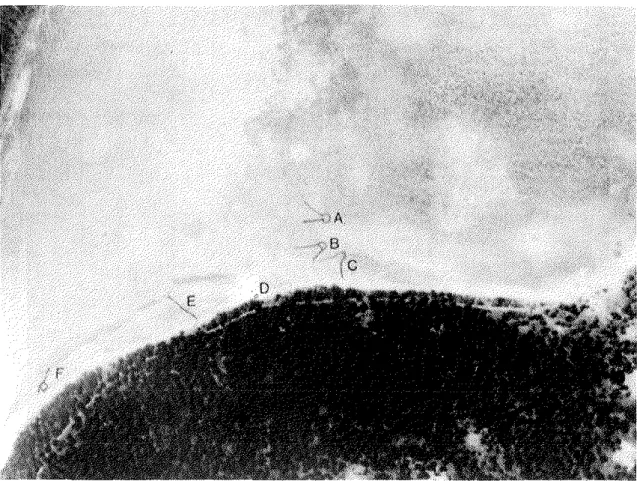
Fish Traps. Situated close to the lagoon shore on the reef flat are various stacked stone configurations, some of which are clearly fish traps, but other features may have had differ- ent functions such as enclosures for holding fish or turtles. These devices show signs of disrepair and probably have not been used for decades. Riley (1987: 187) provided a classi- fication of fish traps from Majuro Atoll but, unfortunately, did not provide illustrations of his types. I adapt his scheme (using his type descriptions) in the presentation of the Ujae features. Riley's type 1 is most common on Majuro and Ujae as well. It consists of a V- shaped configuration that funnels fish to a circular trap (Fig. 8A). Most Ujae examples are situated open to the ocean side and two of the traps (site 5B and C) take advantage of the
FIGURE 6. Small Cyrtosperma pit with a few arrowroot plants in foreground and to right.
I
Ulse Islet. Site 1Eiw8tion t r a n s e ~ t / C y r t o s ~ e r m a it z o n e / m o d e r n v i i I a o e /
@ 0 @ 0 0 0 @
-
fish bone C? shellfish &S urchin pumiceFIGURE 7. Elevation transect through site 1, Ujae islet. Fish bone (counts) and shellfish, urchins, and pumice weights for excavated units.
shoreline which acts as an extension of the landward leg of trap site 5C (Fig. 8). Site 6 is an adaptation of type 1 traps that takes advantage of the lagoonal topography, such as natural alignments of coral, rubble, and depressions, as well as the coastline for extending the
FIGURE 8. Aerial photo of Ujae islet, site 5 fish traps features A-C, possible turtle enclosure feature D, wall feature E, and enclos~~re f e a t ~ ~ r e F. Photo taken 7 February 1944. (Bernice P. Bishop Museum negative number CP 117,081.)
length of the catchment (Fig. 9). This trap is four times as long and three times as wide as the west coast features of similar form. On Majuro, large schools of the Bigeye scad (Selar crumenopthalmus) are caught in similar traps (personal communication, Laura, Majuro resident, 1994). The Yellowstripe goatfish (Mulloidesflavolirzeatus and M. vanicolensis), which congregates in large schools over sand flats, may also be a species commonly caught in stone traps.
Site 5E uses the local topography to aid in directing fish-a similar situation to the type 1 traps. Extending from the shoreline, a low wall was built perpendicular to a ridge on the reef flat, thus forming a three-sided square open to the ocean side (Figs 8 and 10, middle).
There is no circular trap as in the type 1 features, while this square configuration may have been used in conjunction with a seine net that closed the fourth side of the trap.
The two legs extending from site 5F may have acted to help channel fish to the square enclosure, but the exact function of this feature is uncertain (Fig. 10, lower). It is somewhat similar to the description of Riley's type 3 traps (1987: 187). Site 5D is a circular enclosure measuring about 3 m in diameter (Fig. 10, upper). This may have been a turtle pen as similar, but larger, structures have been noted elsewhere in the Pacific on islands with shal-
FIGURE 9. Aerial photo of Ujae islet, site 6 fish trap. Photo taken 17 February 1944.
(Bernice P. Bishop Museum negative number CP 117,086.)
low offshore topography (Emory 1939:17). Riley's type 2, a semicircle that joins at the beach, was not seen on Ujae Atoll.
In summary, Ujae fish traps were built to take advantage of the local offshore topogra- phy and were situated in reference to prevailing currents. Both topography and currents acted to enhance the efficiency of the traps, which could be checked after each incoming tide. Although a range of fish species were undoubtedly trapped, Bigeye scad and goatfish may have accounted for significant catches. I have observed seine net catches of hundreds of rabbitfishes (Siganidae) on Utr6k Atoll, and it is reasonable to suspect that species of this family may have been caught in traps as well. The variability of forms in Ujae fish traps and enclosures warrants a more inclusive classificatory scheme for the Marshall Islands fea- tures that should be adapted from Riley's initial attempt at describing the Majuro sites. It is worth noting that traps were only associated with Ujae islet probably reflecting the rela- tively larger village there. These devices may be a form of intensification of the marine subsistence regime, built during late prehistory. It is unlikely that traps would have been constructed as part of the colonization phase of settlement when marine stocks were at their highest levels and capturing fish required less effort.
FIGURE 10. Site 5 possible turtle enclosure feature D (top), wall feature E (middle) built perpendicular to natural reef alignment, and enclosure feature F (bottom).
TEST EXCAVATIONS
Excavations were conducted primarily on Ujae islet, where 8 m2 were completed at the major habitation (site I), with an additional 1 m2 dug at site 3 on Bock islet. The objectives were to: (1) determine the depth and nature of the prehistoric cultural deposits; (2) obtain samples for radiocarbon dating; (3) collect shellfish and faunal material to address subsist- ence issues; (4) acquire artifacts from secure stratigraphic contexts; and, in the case of site 1, (5) determine the lagoon to ocean side site boundaries. Experience has shown that it is simply not possible to accurately determine habitation site boundaries on atolls without excavation.
Unit excavations proceeded by arbitrary 10 cm levels or spits within, but never crossing, stratigraphic boundaries. All sediments were passed through 114" (6.4 mm) sieves, then material sorted into one of several classes which normally included: artifacts, bone, shell, urchins, crustacea, and charcoal. Separating cultural material into these classes reduced the amount of breakage during shipment and facilitated lab work. The stratigraphic profile of at least one side of each excavation unit was drawn, recording such layer characteristics as boundary, Munsell color, texture, consistency, structure, etc. Elevation transects were made through the excavation units from the lagoon shore to the ocean side showing the topo- graphic features and vegetation of the islet.
Site M1,Uj-1, Ujae Islet
At the major habitation site of Ujae Atoll, seven one meter square units were excavated along a north-south transect running due south (180") for 420 m from the middle of the lagoon shore (Fig. 7). As time permitted, an eighth unit was placed 250 m east of unit 2 to determine the limits of the site boundary along that axis. Stratigraphic profiles are pre- sented in Figures 11 and 12 and detailed layer descriptions provided in Appendix 1. The cultural layer was thickest and oldest on the lagoon side, just north of the aroid pits, and generally thinned north and south of this point. In general, the upper 20 cm of each excava- tion unit contained dense coconut roots in a gravelly sand matrix. In the midst of the mod- ern village, unit 5 had a surface layer of water-rolled coral pebbles-a typical pavement found throughout villages today. Except in units 2 and 5, all cultural material was contained in the top 25 cm in a gravelly sand to coarse sand, black to dark gray matrix. Portions of combustion features were encountered and included earth ovens (see Fig. 11, unit 5, S profile) and other smaller and thinner features that may have been ovens, or charcoal and oven stone concentrations may have served for roasting food. The culturally sterile subsoil was encountered near 75 cm below surface and, in unit 2, below one meter. Cultural content is described below.
".
Site MLUj-3, Bock Islet
This small midden site, located just inland of a beachrock formation, suns parallel to the lagoon shore. The site does not extend inland very far, yet is quite long, suggesting that inhabitants preferred to be close to the water, away from the rocky interior. One 1 mZ unit was excavated at the highest point of the site to get a complete sample of the stratigraphy.
Five layers were defined primarily on the basis of color, texture, and artifact content (see Fig. 13 and Appendix 1). Dense gravel was encountered to one meter below surface sug-
Site I Unit 1. E prolils
fins sand
c o a r s e s a n
Site 1
unit 3, E protile gravel pavement
g r a v e l l y s a n d
0
g r a v e l l y s a n d
Bela-74845 grader to rler!le 166Oi80 BP'
site I Unit 4, W profile
site 1
u n i l 5 , pro fils site 1
unil 5. S protile cm
0
d e n s e gravel g r a d e r
25
FIGURE 11. Profiles of units 1-5, site 1, Ujae islet.
site 1 site 1
unit 6, w profile loore sand Unit7. W profile
,$p( ,V( ,gy
I weakly coherent rand
site 1 Unit 8. E profile
FIGURE 12. Profiles of units 6-8, site 1, Ujae islet.
gesting a frequent repaving of the ground surface. The lack of aroid pit cultivation and rocky nature of the landscape indicates that the islet was probably occupied by small groups for short periods of time, perhaps as a staging area in which to exploit the outer reefs and troll for pelagic species. A basal radiocarbon date suggests late prehistoric occupation.
DATING
The selection of samples for radiocarbon dating was constrained by the limited number of excavation units. However, the objectives for securing chronometric dates were to: (1) obtain a set of dates for the basal cultural layer which would establish initial occupation in the location of the units, but not necessarily of the site itself; (2) determine the relatively oldest portion of the site along a transect that would suggest the direction of site expansion over time and how this may correlate to islet formation; (3) contrast the basal habitation dates between the largest islet and at least one site on a small islet; and (4) date a sample of beachrock in reference to an elevation transect for establishing a chronometric benchmark for this topographic feature that may have implications for human colonization of the islet.
Seven radiocarbon samples were selected from clear stratigraphic contexts: four from the largest habitation on Ujae Atoll, site 1; two from the small habitation site on Bock islet;
and a beachrock sample from the ocean side transect on Ujae islet. All samples were proc-
crn 0
25
50
75
100
125
.
J COCO""l ,001_ _ _ _ - - - "a
d e n s e g r a v e !
~ t e i i l e sand layer
... ...
d
... 0
... 0 0 ash 0
0
0
d e n s e o v e n e l o n e s 0
0 charcoal
beach sandsnd cobbiei
0 0 0 0 ,
100 medium-coarse sand
FIGURE 13. Profiles of unit 1, site 3, Bock islet.
essed by Beta Analytic Inc. Pretreatment of the carbonized material consisted of mechani- cal cleaning with gentle crushing, followed by washings in de-ionized water and removal of any rootlets. Acid washes were used to remove carbonates-a potential problem with sam- ples recovered from calcareous sands on atolls-and alkali washes removed secondary organic acids. The beachrock sample was processed in a similar manner. All procedures went normally.
Table 1 presents the details for each dated radiocarbon sample. When possible, discrete combustion features were selected for dating of known material such as coconut shell or husk and Pandanus keys (or drupes). Unidentified wood charcoal was part of two samples and the sole material for one sample. Ideally, it is best to get wood charcoal identified prior to dating to eliminate the possibility of "old" wood that can produce dates not related to the target event (Dean 1978). A thumb-sized piece of wood charcoal was submitted from an oven (Beta-79582) to Gail Murakami of International Archaeological Research Institute, Inc. for identification. The sample could not be identified due to a lack of adequate refer- ence material. It is prudent that atoll reference plants be collected to facilitate wood char- coal identifications which would not only furnish better control for radiocarbon dating, but provide insights into plant use and, perhaps, environmental change during prehistory (Hastolf and Popper 1988; Weisler and Murakami 1991).
The oldest date for the site 1 transect was at unit 2 (AD 256-542), just lagoonward of the Cyrtospenna pit concentration. This area, and similar settings on other atolls, has been shown to produce the earliest habitation dates. It is likely that upon discovering Ujae, the colonists explored the atoll and located the largest islet. It is near the center of Ujae islet that the Ghyben-Herzberg lens would be the largest and thickest and the prime locale for
Table 1. Ujae Atoll radiocarbon age determinations.
Calibrated
Beta No. Provenience 14C 13C/lZC Conventional Material Weight Context 2 0 Range(a)
74845 1-2/11 (119 cmbs) 1680 i 60 -26.2 1660 i 60 1 31.3 in situ AD 256 - 542
76018 1-5/IV (65-75 cmbs) 610 i 70 -28.0 560
+
70 1. 4 23.4(b) oven AD 1289 - 144979581 1-6/III (30-40 cmbs) 100.4 i 00.6% -25.8 100.6 f 00.6% 2, 3 12.1 dispersed modern
79582 1-7/I (20-30 cmbs) 101.0
+
00.7% -26.8 101.3 i. 00.7% 3, 4 74.6 oven modern79583 3-1/III (62-74 cmbs) 70
+
50 -27.4 30+
50 1 62.3 oven AD 1694 - 195576019 3-l/III (112-124 cmbs) 260
+
60 -28.3 200+
60 4 54.4(b) oven AD 1531 - 195595881 Ujae Is. 1 m above reef platform 2100
+
60 -1.7 2540+
70 beachrock 596.0 oceanside BC 315 - AD 130All samples analyzed by radiometric dating technique; 1 = coconut husk; 2 = coconut shell: 3 = Pandanus key: 4 = unidentified wood charcoal.
(a) Calibrated after Stuiver and Reimer (1993). (b) Samples given extended counting time.
aroid pit cultivation. North of unit 2, units 5 (AD 1289-1449) and 6 (modern) produced progressively later dates documenting a clear chronological trend from near the center of the islet to the lagoon. While later habitation dates may reflect differential site use and population expansion, islets do build lagoonward (Wiens 1959) and over a period of several hundred years, new land was undoubtedly forming thus providing additional space for set- tlement.
In the context of islet formation, dating the ocean side beachrock formation establishes when this topographic feature existed (BC 315- AD 130). Admittedly, the sample is not reckoned precisely to modern sea level, but the date may establish a ternzinus a quo, or starting point, in which to determine when the islet could have supported human colonists.
It is unlikely that people colonized Ujae prior to the beginning of the first millennium AD.
This is in agreement with the earliest dates for Ebon, Kwajalein (Shun and Athens 1990), Majuro (Riley 1987), Maloelap, and Utr6k atolls. Few, if any, archaeologists accept the 3000+ BP dates reported by Streck (1990) for Bikini Atoll, where he has yet to provide the cultural context and complete stratigraphic details of the samples.
If the earliest habitation dates are on the largest islet of each atoll, the smaller islets should have later dates of use. While I am not suggesting that people did not use all the islets from initial colonization, the routine, and more permanent use of these locales, was probably after a period of settlement build-up on Ujae islet. As seen today, residents of the main village venture farther afield for bottom fishing in the lagoon, only after stocks are reduced close by. Diminutive islets, especially without a fresh water lens, could only be used for short periods of time and, consequently, may have only supported small groups while capturing birds, collecting shellfish, and fishing the adjacent shores.
In summary, Ujae Atoll may have been sufficiently above sea level about 2000 BP and, having a large enough land mass and resulting Ghyben-Herzberg fresh water lens, could only then support a permanent human population. The earliest habitation date of AD 256- 542 establishes that people settled sometime after the first few centuries AD and used the smaller islets more intensively in later prehistory. The earliest habitation date does not document initial colonization, but suggests that the earliest cultural deposits on Ujae have not been located.
ARTIFACTS
It is on low coral atolls that shell resources are the primary raw material for tool manu- facture. With an absence of local volcanic or continental rocks, the fashioning of shell into a wide range of functional and ornamental artifacts was taken to extreme. For example, in the Marshall Islands, adzes were made from at least seven shell taxa: Tridacna maxima, T.
gigas, Cypraecassis rufa, Cassis cornuta, Lamhis lainhis, Conus sp., and Terebra maculata.
Vegetable peelers and scrapers-modern examples still in use today-were made most frequently from the gastropod Cypraea tigris and probably C. mauritiana and C. maculifera, as well as bivalves including Anadara sp., Asaphis sp., and Pinctada margaritifera. A shell weaving tool was fashioned from Tridacna. The large, flat pearlshell bivalve, Pinctada margaritifera, provided ample raw material for making a range of single-piece fishhooks and trolling lures; Turbo was also used, but to a much lesser extent. The widest spiral near
the apex of large cone shells (Conus leopardus and C. literatus) was shaped into rings that were displayed on arms and hung within greatly distended ear lobes. The raw material for other ornaments, including beads and pendants, was supplied by red-colored Spondylus valves, Conus, and possibly Strombus luhuanus. Abrading tools were made from coral and pumice.
The archaeological assemblage of Ujae artifacts included 35 tools and ornaments of indigenous manufacture (excluding manuports). Most of the specimens are relatively large surface artifacts collected during the survev; however, a few artifacts were subsurface finds
-
(Table 2). I describe the collections underhroad functional classes Shell Adzes
Adzes made from the shells of Tridacnidae-the largest bivalve known-have a wide distribution in the western and northern Pacific and are themost common shaped artifacts found in Marshall Islands habitation sites. The 23 specimens reported here are surface finds
Table 2. Artifacts from sites 1 and 3, Ujae Atoll, Marshall Islands.
Site 1 Site 3 Total Type/Class -
Historic Button Ceramic
GLass Metal Nail PLastic Subtotal Indigenous Abraders
Coral Pumice Adzes
Cyproecassis Tiidacna gigas Tridocna maxima Tridacno sp.
Needle Bone Ornaments
Conus ring Tectus ring
Manuports
Non-oceanic rock Oceanic rock Pumice Worked Shell
Pinctoda sp.
Subtotat
Total
from site 1 on Ujae islet. Because of the relatively small sample size, I followed the classi- fication system devised by Kirch and Yen (1982:208-232) for their analysis of 234Tikopian shell adzes. Three taxa were identified in the Ujae collection: Tridacna maxima, T. gigas, and Cyraecassis rufa, and the adzes are described under each taxon.
Tridacna maxima is the most commonly-used adze material found in the Marshall Is- lands and while present throughout the entire sequence, it is more often associated with late prehistory. Fifty percent of the Ujae adzes identified to species are T. maxima (Fig. 14a).
Adzes were commonly shaped from the valve's dorsal region where the long axis of the adze blade was perpendicular to the radial flutes (see Kirch and Yen 1982:fig.84). This is the region of the valve where the longest adze could be obtained. Also within the dorsal region, 9 of 1 1 (82%) of the adzes incorporated the area demarcated by the retractor muscle scars undoubtedly because this surface is more parallel to the valve's exterior than any other portion of the shell. Consequently, less grinding would be necessary to derive the final adze shape. It may also be that the shell material is denser and more durable at the retractor muscle scars and, consequently, may have produced stronger adze blades. Of the three adzes where valve side could be determined, all blades were made from the ventral valve (Fig. 14b and c) and measured up to 88.63 mm long. All T. maxima adzes that could be assigned a type were type 3 (Kirch and Yen 1982) which is amore specific classification of Rosendahl's (1987) TRI-EXT (exterior region of the Tridacna valve, literally, Tridacna - exterior). The Ujae adzes typically have 50% or more grinding on all surfaces, are quadran- gular in cross-section with rounded or blunt-shaped butts, and most frequently have slightly curved cutting edges (in plan) that are flat (see Tables 3 and 4).
Four T. gigas adzes (and possibly a fifth, Fig. 15a) display the widest range of variabil- ity in size and shape. This is predictable since T. gigas reach more than 1.0 m in posterior- anterior length and 10 cm thick, supplying a virtual "blank slate" for adze design. From comparisons with modern reference specimens of T. maxima and T. gigas, it is readily apparent based on adze size (Fig. 15c) and thickness (Fig. 15b) that these four adzes can only have been fashioned from T. gigus. The width of SA 17 (Fig. 1%) exceeds that of average T. gigas flutes and was therefore made from the hinge portion of the valve. SA 2 (Fig. 15b) could have been made from the hinge or flute region of thick individual valves.
As a class, these adzes typically exhibit 100% grinding and are the longest in the assem- blage at 134.22 mm. Cross-sections are plano-convex and quadrangular with blunt or pointed butts, slightly curved or straight cutting edges with concave or flat bevels; these adzes are similar to Kirch and Yen's (1982) type 6 and 8 made from 7: maxima. 7: gigas adzes are generally the oldest forms of shell tools in culture-historical sequences from the western and northern Pacific. It is interesting to note that SA 17 (Fig. 15c) may have a residue on the proximal region of the back that may be the result of hafting.
The second most numerous group of Ujae adzes were manufactured from the lip or whorl of the Bullmouth Helmet shell Cyraecassis rufa. A number of authors have confused this taxon with the Horned Helmet shell (Cassis cnrnuta) when referring to some adzes made from the lip or whorl (e.g., Beardsley 1994:photo 15; Kirch and Yen 1982:fig.91g;
Shun and Athens 1990:fig.3 specimen 2). Although adzes, chisels, and gouges were made from the lip of Cassis cornutu and Cypraecassis rufa, only whorls of the latter taxon where fashioned into adzes. I have seen no adzes made from the whorl of Cassis cornuta either in
FIGURE 14. Tridacna maxima shell adzes. ALL specimens made from the dorsal region o f the valve, perpendicular t o the radial flutes. a and b = finished forms; c = adze preform flaked t o rough shape, ready for grinding. Artifacts b and c made from the ventral valve.
Table 3. Discrete a t t r i b u t e s of Ujae shell adzes*.
Catalog Cross- Butt Shell Grinding Cutting Edge Kirch &Yen (1982)
Taxon No. Staqe Portion section Shape Region Location Grinding % I n Plan Bevel Classification
Tridacna maxima Tridocno maxima Tridacno maximo Tridacna maximo Tridacno maximo Triddocno maximo Tridacno maximo Tridacno maxima Tridocno maximo Tridacno maximo Tridacna maxima Tridacno sp.
Tridacno gigas Tridacna gigos Tridncno gigas Tridacna gigos Cypraecassis rufa Cypraecassis rufo Cypraecassis rufa Cypraecassis rufa Cypraecossis rufa Cypraecossis rufa
finished finished finished finished finished finished finished finished preform finished finished finished finished finished finished finished finished finished finished finished finished finished finished
midsection quadrangular butttmid quadrangular whole quadrangular mid+edge quadrangular b u t t i m i d quadrangular mid+edge quadrangular mid+edge quagrangular whole quadrangular whole quadrangular whole quadrangular b u t t i m i d quadrangular mid+edge quadrangular whole plano-convex b u t t m i d plano-convex whole quadrangular
butt ?
mid+edge concave-conve) whole plano-convex whole concave-convep whole concave-convex mid+edge concave-conver whole olano-convex
- rounded rounded - blunt -
-
rounded rounded blunt rounded
-
blunt rounded pointed rounded - round pointed pointed
-
pointed mid+edae concave-convex -
dr dr dr dr?
dr?
v, dr dr v, dr v, dr dr dr
?
?
?
?
? whorl
lip whorl whorl whorl lip whorl
- - straight
curved - slightly curved
straight slightly curved
- slightly curved
- curved slightly curved
- straight
-
curved curved slightly curved slightly curved
curved curved curved
- -
- 3
flat 3
flat 3?
- 3
flat -
flat -
flat 3
- 3?
flat 3
- 3
flat 8
concave 6
- 6
flat 8
- 8?
flat 10
flat 9
flat 10
flat 10
flat 10
concave 9
flat 10
Cypraecassis rufo SA 2 6 *
* abbre~ations. Shell Region: dr = dorsal region, v = ventral. Grinding Locations: f = front, b = back, s = side.
Kirch and Yen (1982) types 6 and 8 refer t o Tridacna maximo, although the Ujae T. gigas adzes appear t o be similar i n form
Table 4. Continuous attributes of Ujae shell adzes*.
Catalog Width Width Width Thickness Thickness Cutting Ratio Ratio Ratio
No. Length Cutting Edge Midpoint Poll Midpoint Butt Weight Edge Angle WT W L TL Taper
* abbreviations. Ratio WL = ratio of midpoint width/rnidpoint thickness; Ratio WL = ratio of midpoint width/length;
Ratio TL = ratio of midpoint thickness/length; Taper = ratio of midpoint width/poll width.
FIGURE 15. Shell adzes of Tridacna gigas typically display a wide range o f cross-section form.
publications or in the Alele Museum (National Museum of the Marshall Islands) collec- tions. Inspection of whole and fragmentary reference shells shows clearly that the whorls of Cassis cornuta are much thinner with an uneven surface. Five of seven (71%) specimens were made from the whorl of Cyraecassis rufa shells at least 138 mm long (Fig. 16c and d).
Grinding is minimal on the back and sides and is not required on the front surface. All specimens are concave-convex in cross-section with curved to slightly curved, flat cutting edges at an angle of 40-55" (see Tables 2 and 3). These specimens are type 10 of Kirch and Yen (1982). Two adzes made from the lip region are both plano-convex in cross-section and are classified as type 9. Grinding is minimal (Fig. 16a) to 100% (Fig. 16b) The cutting edges are curved and flat or concave.
Abraders
These artifacts were used for shaping and smoothing relatively soft material-such as thin shells (e.g., Conus sp. and Pinctada sp.), wood, and bone-into tools and ornaments.
A single Acropora sp. branch coral abrader has a rounded and smooth surface that would be ideal for shaping the interior bend of pearlshell fishhooks. It measures 71.22 mm long and
FIGURE 16. Adzes made from the Lip region (a and b) and body whorl (c and d) of Cypraecassis rufa.
weighs 6.0 gms (Fig. 170. According to Rosendahl, who made extensive surface collec- tions throughout the Marshalls, and my examination of the artifact collections in the Alele Museum, Acropora sp. branch coral abraders are much less common than the Porites sp.
forms that are angular and blocky (cf. Rosendahl 1987:fig.1.67, a, c, and h with Fig. 170.
Four pumice abraders (mean length = 40.92 mm; mean weight = 4.28 gms) each have multiple worn facets that were used to shape flat and convex surfaces (Fig. 17g, h, and i).
Fosberg (unpublished, cited in Sachet 1955: 12) reported that a large black, coarse-grained, hard pumice was seen in use as a whetstone for machetes on Bock islet, Ujae and a similar piece was found inland in the northeast region of Ujae islet. It is plano-convex with use- wear on the flat surface and measures 106.20 mm long and weighs 158.6 gms.
Worked Pearlshell
Only one piece of clearly worked shell was recovered. A 28.10 mm long specimen (16.08 wide and 4.72 mm thick) of Pinctada sp. may be the by-product of fishhook manu- facture (Fig. 17c). It is slightly ground on a portion of the interior surface.
Ornaments
Shell rings are the most ubiquitous ornaments found in the Marshall Islands and have been referred to as arm bands, bangles, or circular units, to name just a few (cf. Kirch 1988). The rings were variously worn on lower and upper arms as well as within greatly stretched ear lobs. The rings were most commonly made from the largest cone shell (C.
leopardus or C. litteratus), although Tectus and probably Trochus were also used. Portions of four rings were recovered from Ujae, displaying three styles made from Conus and Tectus.
The largest ring fragments-with projected diameters of 60 and 80 mm-display up to four neatly-incised parallel grooves (Fig. 17a) and are similar, but not identical, to a ring re- ported from Ebon Atoll (Rosendahl 1987:fig.1.761). The illustrated Ujae ring measures 16.69 mm wide and 3.00 mm thick, while the second one measures 5.29 mm thick with an incomplete width. Another Conus ring has raised parallel margins and an estimated whole diameter of 50 mm, a width of 13.91 mm, and 2.26 mm in thickness in the center (Fig. 17b).
Despite being only 18.41 mm long, a shell ring fragment of Tectus has a reconstructed diameter of 60 mm; it has no design.
A small Terehra cf, dimidiata shell (length = 83.18 mm) has a hole chipped near the aperture to facilitate suspension as a pendant (Fig. 17e). No other Terehra shell pendants have been reported from archaeological contexts in the Marshalls.
Bone Tool
Possibly made from a mammal long bone, this elongate, flat, pointed artifact measures 76.57 mm in length and, at the center, is 7.72 mm wide and 2.65 mm thick; it weighs 1.6 gms. The proximal portion is biconically drilled, while the pointed end is worn and blunted probably from use as a thatching tool or needle (Fig. 17d). It is covered with scratches oblique to its long axis and has a polished appearance overall. This is the only known example of this artifact type from the Marshalls.
FIGURE 17. Assorted artifacts from Ujae excavations a = Conus shell ring fragment with four neatly incised grooves; b = Conus shell ring fragment with slightly raised edges;
c = worked pearl shell (Pinctada margaritifera); d = possible thatching needle made from mammal (7) bone; e = Terebra pendant; f = Acropora sp. file or abrader; g - i = pumice abraders with f l a t and rounded used surfaces.