ATOLL RESEARCS BTJLLETIN
----..-"---"--
NO. 116
Reef s t u d i e s a t Addu A t o l l , Maldive I s i a n d s
Prelirninarg r e s u l t s of a n e x p e d i t i o n t o Addu A t o l l i n 1960
E d i t e d by David R. Stotidai-t
Isslted by
THE PACIFIC SCIENCE BOLED
N a t i o n a l Academy of s c i e n c e s - - N a t i o n a l Research Council Vashingron, D. C.
:.larch 31, 196C.
Page
-
I. I n t r o d u c t i o n
. . .
111. Climate amd marine environment
. . .
7. .
111. Geomo?phology of i d d u k t o l l , by D. :.1. S t o d d a r t ,
. . .
P. Spencer Daoies and A. C. K e i t h 13
I V , P r e l i m i n a r y l i s t of s t o n y c o r a l s from Addu A t o l l ,
. . .
by J. T!. !!ells and P. Spencer Davies 63
V. Ve",tation and flo-ia
A. A b r i e f h i s t o r y of b o t a n i c a l o b s e r v a t i o n s and c o l - l e c t i o n s made i n t h e pialdive I s l a n d s , I n d i a n
Gcean, by E. Ti. S ~ o v e s
. . .
57G. Ptelin~ina-iy account o f t h e l a n d and marine
v e g e t a t i o n of Addu .:_toll, by D. C. S i g e e
.
I.1C, L i s t of Addu
.
. vascuiai.. p l a n t s , . b7 I?. 2. Posbezr, 0 )E. T!. Groves, and D. C. 2 i ~ e . e
. . .
75D. iiariize b e n t h i c a l g a e ?corn Addu A t o l l , Pialdive
I s l a n ~ s , by Xoy T. Tsuda and Jan Nev7house
. . .
93'11. Addu i n 1C36
. . .
. I 0 3. .
. . .
V I I . G i b l i o p n p 5 y of t h e Malclive I s l a n d s .I07
I l l u s t r a t i o n s
. . .
F i z u r e 1. The i i a l d i v e I s l a n d s , a f t e r Parquharson (1936) ii
. . .
2. Aridu A t o l l , based on Ailrniralty Chart HO. 2067 1
. . . .
I k a n r o n t i ~ l y wind d i r e c t i o n s a t ,$an I s l a n d ,
19CO-13C4.
. . . . . .
11i o n t h l p t e m p e r a t u x s . a < Gan, October 1557-
September19C2
. . .
"'arise of i a i n f a l l and roean monthly r a i n f a l l a t Gan,
Gctobej: 1957-June if:?.
. . .
I +Pxed.icter? t i d e s for A u p s t and September 13C4
. . .
':Zonation of iialclivien ~ e e f s , a f t e r E i b l - X i b e s f e l d t ( l 3 6 i 1 . ) /:l Di.azramnctic c r o s s - s e c t i o n of pezipilezal a t o l l r e e f s
. .
"E c o l o z i c a l z o n a t i o n on t h e seaward r e e f f l a t a t
Gan I s l a n d
. . .
,. .
I ILazoon f l o o r of Addu Atoll
. . .
.:L o c a t i o n of echosounding p r o f i l e s i n Addu A t o l l lagoon
. "
Acldu M o l l l a z o o n echosouncl.ing p r o f i l e s 1-3
. . .
':I?<.du A t o l l lazoon echosoundin8 p r o f i l e s 4-7
. . . '.
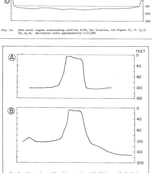
F o l l o x i n p pabe, Addu A t o i l lagoon echosounding p r o f i l e s 9-10
. .
4 1Echosounding p r o f i l e s of lagoon p a t c h r e e f 2 4
.
,. .
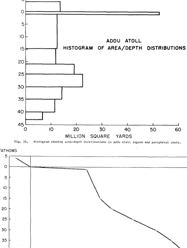
i fIlistograin shoving a r e a - d e p t h c i i s t r i b u t i o n s
I n Addu A t o l l lagoon and p e r i p h e r a l r e e f s
. . . .
I IH y p 0 ~ 0 m e t r i c curve f o r Addu A t o l l lagoon
and p e r i p h e r a l r e e f s
. . .
I tP e r c e n t a g e hypsornetric c u r v e s f o r Addu, Rongelap, Enir.retolc, B i k i n i and Rongerik
A t o l l s
. . .
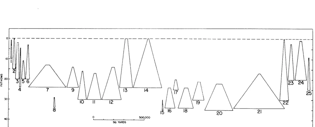
l iLocat-ion and index numbers of Addu A t o l l lagoon
p a t c h r e e f s and k n o l l s
. . .
/ ICepth-area dCstrii7ution of Addu lagoon p a t c h
r e e f s and k n o l l s
. . .
;'D i s t r i b u t i o n of number of c o r a l s p e c i e s a c r o s s
Gan l a s o o n r e e f t r a n s e c t s I and I1
. . .
< :D i s t r i b u t i o n of growth form of c o r a l s a c r o s s Gan lagoon r e e f t r a n s e c t s I and I1
L o c a t i o n of beach s e c t o r s and beach p r o f i l e s a t G a n I s l a n d . . .
. . . .
.R e l a t i o n s h i p between beach h e i g h t and beach
a n g l e a t Gan and Hitaddu I s l a n d s
. . . ' .
Sediment sarnplinz s t a t i o n s , seaward r e e f f l a t ,
Gan I s l a n d
. . . "
Sediment sampling s t a t i o n s , lagoon f l o o r ,
Bddu A t o l l
. . .
, ISample cumuletive frequency c u r v e s f o r sec'iment
s a m p l e s .
. . .
t :P . e l a t i o n s h i p between median s i z e and s o r t i n g i n
sediment samples
. . .
I /Following pas5
-
29. V e g e t a t i o n of Gan I s l a n d , 1964
. . .
7430. D i s t r i b u t i o n of number of a l g a l s p e c i e s on
t h e seaward r e e f f l a t
. . .
31, D i s t r i b u t i o n of number of a l g a l s p e c i e s and percentage. c o r a l c o v e r i n Gan lagoon r e e f
t r a n s e c t l
. . . "
32. D i s t r i b u t i o n of number of a l g a l s p e c i e s and p e r c e n t a g e c o r a l cover i n Gan lagoon r e e f
t r a n s e c t I I . . .
. . . "
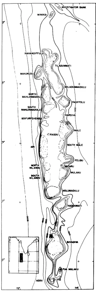
Fig. 1. The Maldive Islands, after Farquharson (1936).
Fig. 2. Addu Atoll, based on Admiralty Chart No. 2067; 1 kilometre location grid overlay.
I. INTRODUCTION The Maldive Islands
-
The Maldive Is1and.a proper ( ~ i g . I), between IhavandifNu and Haddumati Atolls, form a double chain of a t o l l s , r i s i n g from a sub- marine plateau o r ridge, 150-210 fathoms deep, 350 nautical. miles long, and up t o 70 nautical. miles wide. 'Inne a t o l l s are separated by channels which axe deeper than t h e general. plateau surface, and a t the edge of the plateau the sea f l o o r faJls steeply t o between 1000 and 1400 fathoms on the e a s t side, and t o 1300-2000 fathoms on the west side. The & features of t h e bathymetry were f i r s t recognized by Gardiner (~902, 1903-6), and subsequently confirmed by Farquharson
(1936).
Both
to
north and south of the main plateau the bottom topo- graphy i s l e s s clear. Minikoi, i n the north, i s linked t o the main Maldive plateau by a shelf a t 700-900 fathoms. In the southern Maldives, the plateau may be interrupted between Haddumati and Suva-diva Atolls a t about 900 fathoms. Between Swadiva and Addu Atolls the plateau does not seem t o e x i s t : the minimum sounding midway between the two a t o l l s i s
845
fathoms, r i s i n g t o654
fathoms 12 naut-i c a l miles north of Addu, and most of the soundings range from 1000 1200 fathoms. The existence of a deep ridge seems clear, however, f o r on e i t h e r side of a l i n e joining the t w o a t o l l s , a t depths of about 1000 fathoms, the floor f a l l s t o depths of 1300-1500 fathoms on the e a s t side, and t o 1400-2000 fathoms on the west. The relation- Ship of Fua VN3.aku Island, between Addu and Suvadiva, to t h i s ridge i s unknown.
South of Addu, between the Maldives and the Chagos Archipelago, soundings are few. Inmediately south of Addu, depths of 1200 fathoms are recorded, increasing t o more than 1800 fathoms a t 3OS. This sug- gests t h a t the Mid-Ocean Ridge, extending northwards t o the Chagos a t about 6 7 O ~ longitude, and swinging northwestwards f r o m there t o - wards the Gulf of Aden, thus forming the Carlsberg Ndge with depths
Of about 1000 fathoms, does not continue uninterruptedly into the Maldives ( ~ e e z e n 1962; Heezen and Ewing 1963, 396; Heezen and Tharp 1964). Recent workan the structure of the Indian Ocean has con- centrated on the Carlsberg Ridge, and does not make i t s relation- ship with the W d i v e s ridge clear. A t the 2000 fathom level the Maldive Ridge is continuous with t h e Carlsberg and Mid-Ocean Ridges:
to the e a s t of the Maldives Ridge the ocean floor l i e s at more than 2000 fathoms, between the Maldives and Carlsberg Ridges it averages 2400 fathoms (reaching 2600 ), and s.w. of the Carlsberg Ridge the f l m r averages 2700 fathoms and i n places reaches more than 2800 fathoms.
Farqlxhmaon (1936) uses the 1300 fathom fsobath to c l e l l m i t the Mal- dives Ridge, thus includjny Minikoi and Addu; most of the Maldives a t o l l s are coanected at the 300 fathom level.
Most observations on the structure of the Maldives have been speculative. Darwin (1842, 1 1 0 ) ~ followed by h v i s (1928, 527-532)
,
suggested t h a t subsidence of an island l i k e New Caledonia, w i t h reef
upgrowth, could form such a double chain of a t o l l s . Gardiner (1902, 1903) believed t h a t the main Maldives plateau. as formed by current erosion, and t h a t the a t o l l s themselves were subsequently f o m d b y the growth of deep- and l a t e r shoal-water organisms on t h i s forraa- tion. During the John Murray Expedition, Glennie (1936) made gravity readings a t several stations, including Midu Island, Addu Atoll.
These showed a strong negative anomaly along the whole Maldives ridge, which Glennie interpreted
as
indicating a thickness of several thou-sand f e e t of reef limestone. Magnetic anonaly studies carried out by H.M.S. Owen i n 1962 demonstrat=& small f i e l d changes i n the Mal-
dives and Laccadives, which were interpreted as indicating the presence of a continental basement
askel ell
and others, unpublished data). In contrast t o the mid-ocean riage characteristics of the Carlsberg Ridge (high heat flov, seismicity, vulcanicity ( H i l l and others 19&)), the haldives and Laccadives area i s notably aseismic.-studies i n the Maldive Islands
Several large expeditions have v i s i t e d the Maldive Islands reefs, yet pasadoxically they remain one of the l e a s t known groups of a t o l l s . Unlike Pacific a t o l l s , the Maldive Islands have been known t o the west since medieval times. l 3 n Battuta v i s i t e d the islands i n 1327 and gave the f i r s t recognisable a,ccount of Maldivian l i f e (Ibn Battuta 1.8?9,
1854-8,
1890, 1929). In 1602 F r a n ~ o i s Pyrard de Laval was ship- wrecked i n the Maldives, lived there f o r five yews, and wrote a spjs- iLed account of topography, vegetation, and native l i f e ( w a r d 1887- 1890). A t t h i s t i m Portuguese influence i n the islands was great, since the Maldives lay across the shipping route from Xuropc t o the Far East. Scientific investigation properly began i n the Wddives v i t h Commander R. Moresby's hydrographic survey f o r :he East India Company i n the 1830s, a survey vhich f o r most a t o l l s forms the basis of current charts. Moresby's remarkable survey of so large an area resulted i n charts of great elegance, but h i s vessel carried no naturalist, and he does not appear t o have concerned himself with reef physiography or fauna. Apart from h i s own brief memoir (Moresby 1835), and some botan- i c a l and general data by other officers (Christopher18k1,
Horsburgh 1832, Owen 1832, Young and Christopherlw),
the only published con- clusions on the reefs of the Maldives from t h i s survey are those of Carwin (1842), based on communication with Moresby himself. Moresby's two nautical memoirs, on the islands of the Indian Ocean, and on the Maldives, remain i n manuscript.The major advaxe i n s c i e n t i f i c knowledge of the Maldive Islands dates from the expedition led by J. Stanley Gardiner of Cambridge Uni- versity t o the M t i i v e s and Laccac2ives i n 1899-1W. Gardiner's work was mainly zoological, and h i s collections, based on extended stays a t Minikoi and South W e Atolls and brief excursions through the whole group, were published i n tvo large quarto volumes and a series of papers.
Gardiner himself contributed studies of reef and i s l a d physiography and speculated on the coral reef problem and the origin of the MaL- dives (cardiner lgOOa, 1900b, 1901b, 1902, 1903a, 1903b, l906d, 1930, 19311, as w e l l as working up some groups of scleractinian corals (Gar- diner 1906b, 1906c, 1909, 1929). In spite of h i s reef experience i n
t h e Westem P a c i f i c , however, Gwdiner tras no physiogapher, and many of h i s ideas on tile Recent h i s t o r y and development of the r e e f s and i s l a n d s must be discounted. H i s major contribution l i e s i n the sys- tematic l i s t s of l a n d and marine fauna (Gardiner 1903-6), and i n h i s b o t a n i c a l col!.ections (land f l o r a : Willis and Gardiner 1903; marine
f l o r a : Foslie 1903, Earton 1903), which u n t i l r e c e n t l y remained unique.
It i s d i f f i c u l t t o obtain from Gardiner's tmrk any p r e c i s e idea of t h e s t r u c t u r e of modern Maldivian r e e f s , o r of the d i s t r i b u t i o n and r e l a - t i v e importance of c o r a l s and other reef organisms. A number of groups, incl-uding .the senus Acropora, &so remalned mo'aographed.
-
Without Gardiner's vork, ho6;er, our lmotrledge of t h e Maldives would be sparse indeed. Gardiner ~ihs follotred by .Alexander Agassiz, vho spent two months i n 1901-2 cruising through the .whole archipelrgo, making a la2@ number of shipbomd observations and dedxctions (AgassizLWZa, 1903). Many of Agassiz's p l a t e s a r e of i n t e r e s t , 'but i n gener- a l h i s work is of small value compared with t h a t of Gardiner.
The major event of the inter-trar period was t h e John Ymray Ex- pedition 1933-31k, l e d by R. B. Seymour S e x l l . Sewell, who had
already published on t h e r e e f s of t h e Indian Ocean (Sewell 1932, 19351, c a r r i e d out g r a v i t y surveys and deep soundings i n the Maldives (Glen- n i e 1936, Farq~rharson 1936) and published physiographic descriptions
Of Addu and Goifurfehendu A t o l l s (Setrell 1936aJ l936b). Like Gar- diner, Seriell was a zoologist, not a marine geologist, and h i s chief work was on t h e Copepoda. H i s physiographic rforlr, while of g r e a t value, contains many untenable speculations. Taken together, however, Gardiner's and Sewell's expeditions provide the g r e a t e r p a r t of our h o ~ < l e d g e of the a t o l l s and t h e i r reefs. Subsequently, Gardiner l e d the Percy Sladen Trust Expedition t o the Indian Ocean i n 1905, which, v h i l e not d i r e c t l y concerned with t h e Maldive Islands, l e d t o Mat-
tha-1's s t u d i e s of t h e IndLan Ocean c o r a l s ( ~ a t t h a i 1914, 1924, 19281, including many of Gardiner's type speciuens from t h e Maldives. The r e p o r t s of t h e Percy Sladen Expedition contain much m a t e r i a l r e & - van* t o the study of t h e Mdldive Islands ( Gardiner 1907-1936).
The pre-1945 l i t e r a t u r e i s l a r g e l y completed by reference t o a s e r i e s of r e p o r t s by I$. C. P. B e l l (1882, 1921, 1940) which, thou&
l a r g e l y h i s t o r i c a l , include zuch topographic d a t a and information on f l o r a and native names of plants. Gray (1878) compiled a v o c a b u l ~ y . A few expeditions touched a t t h e Maldives, including the Deutschen Tiefsee Expedition (chun 1905) and the S.M.S. Planet ( ~ U b b e r t 1909).
A f u l l bibliography i s given by Sachet and ~ o s b e r g c l 9 5 5 ) , and a?-so i n t h i s paper.
The l i m i t a t i o n s of these d a t a becane ~ " p p r e n t with the increas- ing number of P a c i f i c reef s-Ludies & t e r 1911.5. Etnphasis i n these on r e e f dis-Lri.bntioa, ecolo(=y and s e d i ~ e n t o l o g y , r a t h e r than on syste- matics, gave r e e f s t u d i e s new impetus. When Wens summarised post- w a r work i n 1962, therefore, the r e e f s of the Indian Ocean received v i r t u a l l y no mention, although t h e MaLdives include some of t h e
l a r g e s t a t o l l s on earth, and many have unique c h a r a c t e r i s t i c s unlmo~m i n P a c i f i c and Caribbean a t o l l s . The need f o r f u r t h e r s t u d i e s of Maldivian r e e f s became more apparent, b u t f o r p o l i t i c a l reasons few
, s c i e n t i s t s vere a t , l e t o v i s i t t h e area. The Xarifa c a r r i e d out sys- tematic skx%ies i n 1957-8, under Ha.ns Hass, which are i n the course of publication (Hass
1961,
1965; Sib1 -Xibesfelat 1964); . Hass I s own contributions on marine gcol3gyass
1962a, 1962b, 1963) are l a r g e l y speculative. k s b e r g (1956) b r i e f l y v i s i t e d Iviale i n 1956, and puh- l i s h e d a revised and augmented version of Trimen's (1.896) and W i l l i s and Gardiner's (1903) f l o r a . Deraniyagda (1956) published the r e - sul-ts of ecologicd- c o l l e c t i n g i n 1932, and Kohn (1964a) has published mollcccan and general notes f'ol1o:iing v i s i t s t o the southern a t o l l s i n1957.
Both the Te Vega and the Anton Bruun have v i s i t e d the bZaldives-- -- --
i n Comectioa with the I n t e r n a t i o n a l k d i m Ocean lkpedition, b u t r e - s u l t s have not y e t been published, and i n general p o l i t i c a l conditions made extensive ?rorB i n the Maldives during t h i s Etrpedition impossible.
Present expedition
An expedition was, therefore, first planned i n 1962, t o v i s i t t h e Maldive I s l a r ~ d s and t o c a r r y out on a small s c a l e reef s t u d i e s s i m i l a r t o those c a r r i e d out i n t h e P a c i f i c since
1945,
t o provide d a t a on topography, sedimentology, marine geology, and ecology of the r e e f s , reef f l a t s , islands, and o t h e r environments. It was hoped t o work at e i t h e r Male o r Kolwadulu Atolls, b u t t h i s proved p o l i t i c a l l y impossible, and f i n a l l y permission rws given f o r a s m a l l p a r t y t o Work a t t h e Royal A i r Force Staging Post a t Gan Island9 Addu Atoll,southern Maldives, i n mid-1964. For p o l i t i c a l reasons work on i s - lands other than Gan and p a r t of Hitaddu was inpossible, but t r a E r S - ing m d sampling t h e lagoon and i t s r e e f s was allowed. The expedition thus came t o concentrate on reef and i s l a n d envirolments around Gasl Wd, t o a l e s s e r extent, Hitaddu Islands.
Tlie expedition rias l e d by Dr. D. R. Stoddart, Department of Geopaplly, Cambridge, 5rho concmtratecl on topography, sedimentolom
@da m i n e geology of reefs, reef f l a t s m d i s l a n d beaches. Dr. 1'.
Spencer Cavies, lkpartment of Zoology, Glasgow University, collected.
marine invertebrates and x,raras i n charge of' aquaLung work on "the reeffi.
n.
C. Sigee, Department of Botany, Cambridge University, C 0 l -l e c t e d l a n d p l a n t s and marine algae, and Nr. A. C. Keith of the k- Partment of Geography, C m b r i e e University, a s s i s t e d t d t h the Survey- j.llg and sediment sampling progrmmes. The d e t a i l e d r e e f t r a n s e c t s W r e c a r r i e d out j o i n t l y by all members under the d i r e c t i o n Of Dr.
navies. The p a r t y a r r i v e d a t Gan on 1 July 1964, and remained l m t i l September 10. The c o l l e c t i o n s and o t h e r d a t a c o l l e c t e d by t h e expe- d i t i o n w i l l take some years t o w o r k o u t , and t h i s r e p o r t i s hence of a prel~imjnary nature. The &ir, c&ec%ions 'were s e n t f o r ident,ifica:- t i o n a s fo1.l.or.r~: land plnnts, Dr. P. R. Fosberg; marine algae, Yr. I+.
Tsuda; stony coxal n, l k . J. W. Wells.
Previous work a t Addu A t o l l
Being remote :.rom the c e n t r e of a v e r m e n t i n Elale, Addu A t o l l (pig. 2 ) has been v i s i t e d only b r i e f l y by most of the expeditions working i n t h e Naldives. The first d e t a i l e d examination of the a t o l l was made by Comnander R. Moresby and Lieut. F.
.
Powell i n1836,
- 5 -
t h e i r small s c a l e chart being published i n 1839. Moresby's manuscript Nautical d i r e c t i o n s f o r the Maldive i s l a n d s (no date, c. 1837) con- t a i n s an extended a c = t f A d d u c p T ) , reproduced here a s Chap- t e r V I . The f i r s t s c i e n t i f i c account i s t h a t of J. Stanley Gardiner, who spent 11-15 April l g O O a t Addu, making soundings, taking 14 dredge hauls i n the lagoon, and c o l l e c t i n g fauna and f l o r a , c h i e f l y a t Midu and Maradu Islands. For Gardiner's description of Addu, with a sketch map, see Gardiner 1903a, 10; 1 9 0 3 , 150-151; Willis and Gardiner 1901, 78-80; and o t h e r references c i t e d i n t h i s report. Alexander Agassiz spent two days at Addu i n January 1902, published b r i e f notes on Midu, W i l i n g i l i and Gan Islands, and took i s s u e with Gardiner on lagoon f l o o r sedimentation (Agassiz 1903, 145-148). Subsequently H.C.P. B e l l v i s i t e d Addu i n h i s t h i r d t o u r i n t h e Maldives, spending 10-15 February 1922 at Gan and Hitaddu Islands, describing t h e i r h i s t o r i c a l IWminS
h ell
1940, 115-121).During Feb~uary-April 1923, Commaslder F. H. Daugleish, R.I.M.S.
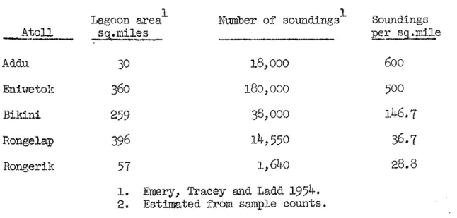
Investigator, c a r r i e d out a survey of Addu A t o l l a t a s c a l e Of 1:18, 136, making approximately 18,000 soundings i n t h e lagoon and the reef channels. U n t i l the pos'6-1945 work i n the M a r s h d l Islands t h i s was the most d e t a i l e d a t o l l c h a r t i n existence, b u t f o r m i l i t a r y reasons it remained c l a s s i f i e d u n t i l
1964.
The published c h a r t of Addu r e - m i n e d t h a t by Moresby, v i t h some corrections, u n t i l t h e c ~ r r e n t Admiralty Chart No. 2067, based on Daugleish's but with a g r e a t l y r e -duced number of soundings, was published i n
1957.
Land t o p o ~ a p h y on Daugleish's chart xias sketchy, and i n some cases had changed Con- siderably since 1923, s o t h a t t h e Daugleish c h a r t was republished i n 1964, with land topography and o u t e r reef d e t a i l from a e r i a l photo- maphy of1958
and 1960. With t h e establishment of the Gan Staging Post, a number of minor hydrographic surveys have been c a r r i e d out t o Supplement Daugleish's chart.Addu was v i s i t e d by t h e John N u r a y Expedition 1933-34. ~ 0 ~ d - in@ ( ~ a r q u h a r s o n 1936) and g r a v i t y p r o f i l e s (Glennie 1936) were' made
8% Addu, and Sewell (1936a) contributed a general account of t h e lrhole a t o l l . This f o r t h e first time described the r e e f s and r e e f - f l a t s , ad4ed a d d i t i o n a l lagoon soundings t o Moresby's and Gardiner's charts, and included notes on Midu, Heratera, and, more b r i e f l y , the o t h e r i s l a n d s . There has been l i t t l e opportunity f o r s c i e n t i f i c work a t Addu s i n c e SewelL1s expedition. The o r n i t h o l o g i s t P h i l l i p s has r e - corded b a t s , amphibians and r e p t i l e s i n t h e Maldives, i n c l u z n g
hilli ips
1958a, 1958b, 1958c, 1958d, 1963; P h i l l i p s and Sims 195%195%). The conchologist Kohn, of t h e Yale Seychelles Expedition, spent a week a t Ad4u i n October
1957,
v i s i t i n g Gan, Hitaddu and W i l - i n g i l i Islands, r e c o ~ < ~ . i n g mol.hsca ( ~ o h n 1964b). Hans Hass with the & x S . f a Ti:qsrijtrl.on v i s i t e d . Addu i n e a r l y 1958 ( ~ I a s s1961,34-63,
00-85; Ei.b7..-RilwsP~l~lL 1.964)~ and sm,ne. systematir: r-cports a r e being publ.ished
h cheer
1960a, Gerlacll 1960, 1961).Ackno~rleQnents
For the opportunity t o work a t Addu A t o l l we p a r t i c u l a r l y wish t o thank the C o m o n ~ ~ r e d t h Relations Office, London; t h e Ministry of
&fence ( A i r ) , London (which a l s o provided t r a m p o r t a t i o n t o and from CW f o r the four mem'oers of the party); and Wing Comander G. Moss, A.F.C., Royal Air Force, Gan, f o r h i s kindness i n allowing us t o >?ark on the island, supplying us r.ri+.h quarters, and allowing us t o use the f a c l . l i t i e s of the O f f i c e r s ' Mess. To many members of the Service and c i v i l i a n personnel at Gan our debt i s considerable, b u t we trould l i k e t o tl1w.k e s p e c i a l l y R. L t . D. Hunter and M r . E. Denis of t h e Gan Sub-aqua C1u.b f o r help i n underwater work and f o r t h e use of t h e launch Victoria. The expedition v'as made possible by generous f i n a n c i a l help from a vari.ety of sources, much of which was sought a t a very l a t e s'coge. We wish t o record our t h n k s t o t h e following f o r help i n t h i s way: The Royal Socie-ty, the Goldsmiths' Company, S h e l l I n t e r n a t i o n a l Petroleurn Limited, t h e Vaughan Lewis Fund of Cambridge University, the University of G1asgor.1, t h e Carnegie Trust f o r t h e Universities of Scotland, B r i t i s h Petroleum Company Limited, the Permutit CoqaRY Limi.ted, Middlesex Education Cornittee, Glasgolr Breweries Limited, and George Ballantine and Son Z w t e d . Ve a l s o thank t h e B r i t i s h Museum
( ~ ~ a t w a l History) f o r t h e loan of c o l l e c t i n g equipment, and the f o l l 0 ~ - ing organisations f o r supplying equipment a t reduced r a t e s : Rank h.e- c i s i o n I n d u s t r i e s L!.&ted, Flallace Weaton Limited, Lillywhites Limited, Fk~lgaam, Weston Limited, Submrine Products Limited, and Kodak Limited.
We a r e wst g r a t e m t o Rear A d m i r a l E. G. Irving, Hydrogcapher, Royal Navy; ,Frofessor J. A. Steers; and Professor C. M. Yonee f o r t h e i r support a t various s t N e s ; t o Dr. F. R. Fosberg and it-. M.-H.
Sachet f o r t h e i r i n t e r e s t and work on the b o t a n i c a l side; and t o the various s p e c i a l i s t s rrho a r e rrorking on the c o l l e c t i o n s .
F r e s e ~ t r e p o r t
This r e p o r t can o d y be preliminary, s i n c e most of t h e c o l l e c t i o n s have ye-t t o be r~orlred up. 1% i s irxtended only a s an o u t l i n e of the work which took place, and t.0 serve a s 9 framerfork f o r f u t u r e r e p o r t s . The conciusions given here on t h e geomorphology and yegetation Of
Addu. A t o l l are, ther.efore, The r e p o r t provides a general account of Ad& Atoll, with a more d e t a i l e d consideration of some as- pects of i t s geomorphology and i t s vegetation. Work on the Z O O L O ~ Y of the r e e f s vi.11 be 'published at a l a t e r date.
Unpublinhed C ~ . o m - c o p y - r i & t m a t e r i a l i n t h e India Office Records transcribed i n Cha@er
VI
appears by permission of t h e Secrztary of S t a t e f o r Comonvealth Rrlations. The bottom topography of Addu A t o l l lagoon i n Figure 1 0 i s derived from Admiralty Original JMcumernt ?Joe C9155?
with t h e permission of t h e liydrographer of the idavy, and the reef and i s l a n d topography, based on a i r photographs, i s repr.02uced from Chart Xo. 2067 of 1964, v i t h the permission of t h e Controller of H M S t a t i o n e q Office and of the Hydrographer of the Navy.Climate
This section b r i e f l y s u m a r i s e s data on c l h t e and marins en- v i m m n t of A d k A t o l l , k d r t n e r (1903, 2 0 4 3 , 25) c
Wbe climate as obsemed in 1900, and s t r e s s e d the v w i a b i L t t y of
W d s , Addu l y i n g too far south f o r t h e m m o o n reversa& .to be Stro7-W
1y f e l t . Gwdrtner estiaonkd aruawd r a i n f a at 150 inches (too &@;h, judgim by recent r e c o r c ~ ~ ) . W e i z ( 1 ~ 3 , 3-45) and S~WYLL ( ~ 9 3 6 s ~
65)
W e similar obsesvations. Addu difYers from t h e norkbem M- dives ( a ) i n i t s g r e a t e r kt& reLinf&l, and i t s l e e s seasonal nature;( b ) i n the weakened e f f e c t of mnsoon wind r e v e r s a s ; and ( c ) Fa 8bsence of typhoons, which o r i g i n a t e in t h e Laccadrtve a r e a and t r a v e l northwmds, m e c o n t r a s t with t r a d e wind a t o l l s i n the P a c i f i c and the Caribbean i s m k e d .
Instmmn.taX r e c o r b k g m t u be kept i n the &?dive fsl.mdS during World W a r 11. WeUs
(lgk8)
r e w r t e d 4 y e w s of obsemations a t W e , end N e w r b m (1.949) cmrlpiled ,wwtime P ~ G O ~ ~ S a t A ~ & U A t o l l f o r the period September 1942 t o Bcember1945,
With t h e e s t d b l i s h - w n t of the R.A,F. Staging Post a t Gan, recording was resumed i n October1957
f o r temperature and r a i n f d l ,an& i n Juue 1960 fop winds.data t o 1964 have been a n d y s e d by the Meteorological C~enkm a t Gan, and the following accomt i n abstracted frum t h e i ~ s m s Y :
"The weather experienced differs l i t t l e from t h a t of the SUP-
rounding 'Iradlan Ocean but t h e heating of t h e land by day and its cooling by night causes an average dl.urnaL v a r i a t i o n of t e m p r a t m e
O f amund lo°F. Only s m a l l v a r i a t i o n s occur i n the surface p m s s w e and these ,we masked by the d i u r n a l pressure v a r i a t i o n which has a range of about
4
mb with p r e s s w e m ~ k x i m a a t about 1000 and 2200 m3Iima a t 0400 and 1600 hours l o c d time. Temperature and humidity Show a l s o only a ~~1 annual. v a r i a t i o n being controlled lW3ely by the w a r m water of t h e Indrtan Ocean, It i s u n u s u d f o r the sky to be e i t h e r overcast o r m e from cloud f o r a day o r more a t a'**, and Wch of t h e cloud i s of the convectionaJ. type, ranging; from f a i m c q t h e r cumul.us t o msmtsive cumulonimbus. During r a i n i e r per-i 0 & there i s often a background of faZtostratus and C ~ ~ O S % - P ~ ~ U S .
flainf8.I.l averages a m m d 90 inches per year, t h e highest 'total So far reciorhd being ~8 inches and the lowest 74 inches. V i s i b i l i - t y is Usutally very good except when r a i n i s f a l l i n g . O C c c l s i o n a ~
in
very heavy r a i n it i s reduced t o l e s s than 1000 yards, S t r o a wind8 o r ga1.e~ ~ u - e r e ~ ~ : i m l y rare, dthough Westerly d n d s durinz a vet sirell blow r a t h e r strongly for scverd day6. However, dur- ing wet spel.1.s s q u a l l s of up t o 70 k t s have been experienced.Sw face winds i n January from between WNW and NNE become mainly North o r Northeast i n February (cf. Fig. 3, where wind data a r e p l o t t e d as monthly wind roses). In March winds a r e evenly a s -
t r i b u t e d between WSW and NNE, b u t i n April become mainlyWesterLy, The
Westerly winds p e r s i s t throiJghout 'ay, then change i n June t o blow from between Southwest m d Sov.tskeest. Throu@hout J u l y 8,nd August rinds a r e between South and Sou.th.east, then change t o a more Southwesterly d i r e c - t i o n i n September; October and Noverier see t h e re-establishment of t h e Westerly, b u t in 3ecember winds become r c r e variable, being i i i s t r i - buted between WSW and NNE.
"The weather a t Gan i s c o n t r o l l e d by t h e migration North and South with t h e sun of t h e b e l t of Equatorial Westerlies unique t o t h i s Wea of t h e hndian Ocean, which l i e between t h e Northeast Trades of t h e %l?iivk% Ikcj2g@re
ma
the Southeast Trades of the Southern Hemis- pha-e.AJ&g
t h ei&q&&.s -tj&,wn
these wind regimes l i e zones of Con77Y?a'sace & ~ L c h give r i s e t o u n s e t t l e d r a i n y weather. The boundary m e e n t h e West,er,lies a d th e ~ o r t h e a s t Trades i s c a l l e d t h e NorthernShear
Line, and t h a t b e t ~ ~ e e n t h e Westerlies and t h e Southeast Trades" e Southern Shew Line. A b i ~ s t illvariably prolonged s p e l l s of Unset-
A bled weather a r e associa'ced with o s c i l l a t i o n s north and south Over of one o r the other of these shear l i n e s .
"Roughly t h e Weather a t Gan divides i n t o f i v e LX&in tSPes, a s f ollaws :
Northeast R-ade type v i t h t h e Xorthern Sheer Line SOU^:^ of G a g , The surface wind i s mainly northeasterly end t h e weather f a i r but sometimes showery.
Distmbed Westerly Type A associated with t h e Northern Shear Line o s c i l l a t i n g n o r t h south over t h e area. The WlYface wind i s mainly Westerly and -the 7reCLther u u s e t t l e d , With periods of heavy r a i n , accompanied a t times with Squalls of between 40 and 70 Bts.
Disturbed Westerly Type B associated t d t h t h e Southern Shear l i n e o s c i l l a t i n g n o r t h and south over the area. The Surface wind i s westerly and t h e weather unse%tle& with Periods of heavy r a i n accompanied at -I;imes with s q u a l l s of between ~ C O and 70 k t s .
"January and February u s u a l l y have e i t h e r m e 1 o r 2 . Masch m d A p r i l u s u ~ d l y have e i t h e r Type 2 o r 3. May, June and July u s u a l l y h m e 'Type 3, 11. o r
5.
August and September usually have !Pype5.
Octob- er and IVovember usually have Type 2,4
o r5.
December usuh!.ly has Type 2.."To complete the summary mention should be made of periods of l i g h t and v a r i a b l e winds ~ i h i c h occur from time t o time i n any month.
They usually last from 2 t o
5
days, but there have been exceptional periods of up t o 12Ws.
The weather i s f i n e but sometimes showery.Shovers when they occur may be h e w y and prolonged, but severe squa.l.1~
of wind are usually absent."
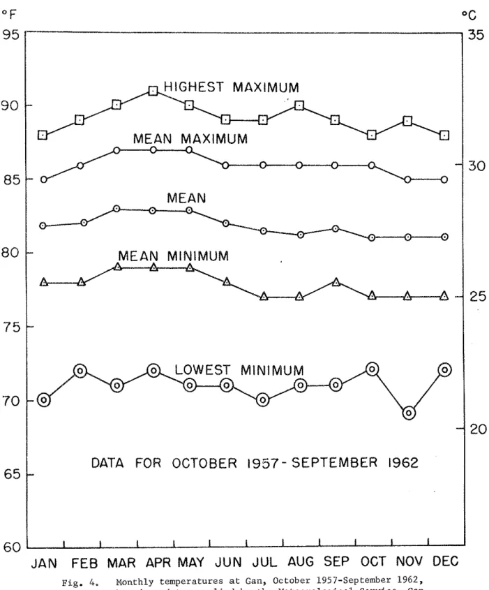
Figure
4
slio~rs annual temperature d a t a a t Gan, October 1957-
Septeniber 1962. The monthly f i g u r e s vary l e s s than 30F throughout the year, which i s considerably l e s s than the diurnal variation.
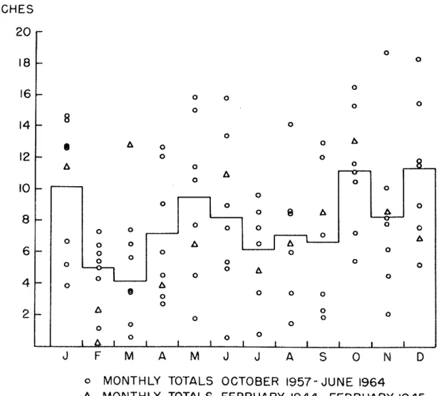
Figure
5
p l o t s mean 'mnthly r a i n f a l l a t Gan f o r the period October1957 -
June 19&, togetkthor with t h e records f o r each month i n t h i s period and f o r the period February 1944-
February1945.
The fi.@eSshow a considerable range i n each month, from a monthly minimum of 0.60 inches t o a monthly m i m u m of
18.75
inches (mean 7.91 inches).There i s no c l e a r seasonal p a t t e r n , except that February and March tend t o be d r i e r than the r e s t of the year.
Currents and t i d e s
&wine currents i n t h i s a r e a a r e v a r i a b l e v i t h the monsoon c i r c u l a t i o n , b u t under the influence of the Equatorial counter- c u r r e n t t h e predominant current d i r e c t i o n appews t o be eastward of nortineastward. "Current observations are, however, scanty i n t h i s region, b u t i.t i s probable t h a t marked v a r i a t i o n s of c ~ ~ r e n t d i r e c - t i o n occur" (west coast of India p i l o t ,
1961,
5 7 ) .T i d d v a r i a t i o n s a r e r e f e r r e d t o the standard s t a t i o n a t Mailras.
Low ~ t e r springs stend a t
0.6
f e e t and high water springs a t 3.8 f e e t , an extreme range of 3.2 f e e t . Low water neaps stand a t1.7
f e e t and high water neaps at 2.6 f e e t ( ~ d m i r a ; ~ t ~ Tide Tables, 2 (1.9651, A t l a n t i c and Indian oceans). A oredicted curve f o r m a r t of 1964 i s given i n Figure6.
~ c c o r d i n g to'the West----
Coast of G a i a Pilot, a t Addu Atoll"the f l o o d stream s e t s strongly i n t o the lagoon through Wilingili channel and out of the lagoon through Gan channel, b u t t h e ebb Stream s e t s out o'f the lagoon through both these channels; thus whereas in Wilingili channel there i s a r e v e r s a l of t h e t i r i a l stream with the change of t i d e , i n Gan channels t h e stream s e t s C ~ n t i n ~ ~ ~ S l y out of t h e lagoon. In Kudu channel, t h e t i d a l streams s e t i n t o t h e lagoon with t h e flood t i d e and out of it with the' ebb, b u t i n 1%2
Kanda channel, the tidal streams s e t dontinuously out of t h e lagoon"
( ~ ~ i ~ r o g r a l j b i c Department 1961, 61).
ContinixiL wave a c t i o n on the reef edge, together with t i d a l v a r i a t i o n , sends a continuow s h e e t of m t e r across the reef f l a t s , P a r t i c u l a r l y between tslands. I n t h e channel between Gan and Fedu
Islands, on t h e Addu reef f l a t , c u r r e n t measurements with fluorescein and with f l o a t s a t high water on
24
August 1964 gave values of 1-2 k t s off the riest end of the runway, and of 1.5 k t s lagoonward of t h ecauseway between t h e two i s l w d s .
Sea temperature a i d saLinitx
,---
Sea temperatures m e approximately 28-290C (82.4-&.~OF) through- out the year. H.M.S. Owen -.A- recorded 28.1-28.8% (82.6-83.8O~) i n t h i s area i n e a r l y 1962, and Agassiz a surface temperature of 27.8Oc (82O~) and bottom temperature of 2'7.80C ( 8 2 0 ~ ) a t 22 fathoms i n Addu lagoon i n January 1902. Temperatures measured during the G a n lagoon reef transect work i n 1964 varied from 27.0 t o 28.0oC. G n the lagoon reef slope temperatures were isothermal t o depths of a t l e a s t
80
feet, but they tended t o be more variable on the reef f l a t . The following tables summarise temperature and s a l i n i t y data recorded by Rr. k v i e s on the lagoon reef transectI
i n1964:
( a ) Variation i n temperature and s a l i n i t y with depth i n lagoon reef transect I.
Depth f t Temp. OC
Surface 28.0
10 28.0
20 28.0
( b ) Variation i n tempe3:ature and s a l i n i t y over the lagoon reef f l a t i n transect I dwi:,y one t j d a l cycle, a f t e r moclerate r a i n w i t h l i g h t rrind from tht? north. Reasngs taken a t surface and a t bottom a t inshore, mid-flat and reef edge locations a t LWST and IIWST on 23 A-st
1964.
0000 h r s , LVST
-I Tempratme Salinity
Zone
-
Sample OC O/oo-
Inner surface w t e r 27.0
bottom (2 ft below) 33.8
27-
5
33.8Reef edge
surface 28.0
bottom ( 3 f t below) 28.0 surf ace
bottom ( 6 ft below) 27.5 28.0
1530 hrs, XJST
Temperatme S a l i n i t y
Zone Sample OC O/OO
Inner surf ace
bottom surf ace bottom
Reef -edge surface 28.0 34.1
bottom 26.0 34.1
These d a t a show a s l i g h t s a l i n i t y gradient across the reef f l a t from land t o sea on t n e l s o o n r e e f . A higher gradient was found on t h e seatrasd f l a t , p w t i c v L a r l y af%er heavy r a i n f a l l , a s sho7.m i n t h e following determinations by Dr. Davies. They may be compased with riormal sea s a l i n i t i e s of 33.8-34,.4 $o i n t h i s area, determined by H.M. S.
-
over, i n 1962.Sample (100 metre i n t e r v a l s S a l i n i t y O/oo
from shore t o seaward e Q e ) Shortly a f t e r Polloving L!JS'P heavy r a i n 1
2 3
4 5 6 7
8 9 1011 ( r e e f edge)
MEAN MAXIMUM
MEAN
MEAN MINIMUM
DATA FOR OCTOBER
1957-
SEPTEMBER 1962I I I I I i I I I I
JAN FEB MAR APR MAY JUN JUL AUG SEP OCT NOV DEC
Fig. 4. Monthly temperatures at Gan, October 1957-September 1962, based on data supplied by the Meteorological Service, Gan.
INCHES
I ~ 0 I 1 0 O I I I I
J F M A M J J A S O N D
o MONTHLY TOTALS OCTOBER 1957- JUNE 1964
A MONTHLY TOTALS FEBRUARY 1944 - FEBRUARY 1945
Fig. 5. Range of rainfall and mean monthly rainfall at Gan, October 1957-Ju'ne 1964, based on data supplied by the Meteorological Service, Gan.
Fig. 6. Predicted tides for August and September 1964, based on data supplied by t h e Marine Craft Section, Gan.
-
1 3-
III. GEOMORPHOLOGY OF ADDU ATOLL by
D. R. Stoddart, P. Spencer Davies nnd A. C. Keith A. General description
Addu Atoll, l a t i t u d e 0°38' South, longitude 73Ol0' East, i s the Southhernmost a t o l l i n t h e Maldive Islands, separated f r o m t h e next n e a r e s t a t o l l t o the north, Huvadu o r Suvadiva Atoll, by t h e
45
mile wide EquatorioL Channel. The next nearest a t o l l t o t h e south i s SdLomon Atoll, Chagos ArYnipelago, 320 miles d i s t a n t . Addu i t s e l f(Fig. 2) i s one of t h e smallest of the W d i v e a t o l l s , measuring 28.4 km (17.6 miles) i n maximum dimension
(mr
t o p o i n t s ) , and16.5
km (10.2 miles) in t h e tzransverse d i r e c t i o n . The a t o l l may be termed semi-circu- l a r o r t r i a n g u l a r : t h e south-facing r e e f s a r e b r o a a y convex, the north- e r n reef concave. The shape may be approximated t o t h a t of a t r i a n g l e , apex Souehtrmds, with a base of 28 lm between t h e northvest and north- e a s t points, and s i d e s of 25 km. Shape measurem?nts by severaJ. methods give v d u e s f o r Horton's F number of0,604,
f o r M i l l e r ' s C i r c u l a r i t y Ratio of 0.754., f o r Schumm's Elongation Ratio E of 0.895, f o r Boyce and C l a r k ' s Radial Line Index o f 28.54, and f o r the E l l i p t i c i t y Index of 1 . 3 (Stoddart, Ln p r e s s ) .The t o t & a r e a of t h e a t o l l i s approximately
60
square n w t i c a i miles, o r 6.5 on Haggettls G s c d e ( m g e t t e t d. 1965). Of t h i s , no l e s s than41%
c o n s i s t s of reef f l a t and islands. The peripheraJ. r e e f sOf the a t o l l axe broad, ranging from 700 metres on t h e north side t o 1900 metres on the south~rest; maxirmun tridths of up t o 2900 metres are found on the northwest projection. T h e r e e f s a r e continuous except f o r t t o gaps i n t h e centre of t h e southern reef
a an
Channel, W i l i n g i l i Channel) and ~ I T O i n the centre of t h e northern reef ( K U ~ U I h d a Chm- ne1, Man 1hd.a Channel). Gan Channel, which i s buoyed, i s 950 metres wide with a s i l l depth of 9-10 fathoms; Wilingili Channel, 750 metres wide, has a s i l l depth of 21-31 fathoms. In the north t h e channelsa r e nmrover: Man Kanda, which i s buoyed, i s 350 metres wide v i t h a 13-18 fathom s i l l ; Iiudu Kanda i s 250 metres vide, with a 13-19 fatifion sill. A l l t h e p e r i p h e r a l r e e f s are of simple l i n e a x form, and l a c k t h e ring-shaped f a r o s so well developed i n t h e northern MaZdives. L i t - t l e i s knorrn of t h e d e t a i l e d topography of the a t o l l slopes. The John Murray Exped-ition r a n a p r o f i l e from t h e northeast corner of t h e a t o l l , recording a depth of 1000 fathoms v i t h i n
k.5
miles i n t h e e a s t e r l y direc.l:ion (mean slope 1lP1o1) and within5
miles t o t h e northeast.Their Som+ings a l s o indica1:eil n. l-irlge s . ~ L ; e ~ ~ d i n ( ; no.rLIleasfmards to~rarda Fua Mil-sku, shvw~i by saiu~dings of 590 and
654
fathoms (Farquharson1936, P l a t e
6).
1I.M.S. Modesta, sounc~ing out of Gan Channel i n 1956, recorded 1069 fathoms1.5
nautira.1. miles s o u t h a s t of the W i l i n g i l i reef edge, giving a mean slope of 350.The a t o l l lagoon i s e l l i p t i c a l , rrith i t s a x i s trending E3E-Wbl.
It has a maximurn length of 11.7 km and breadth of
9
l a . Unlike the northern W d i v e a t o l l s , such a s North Male and A r i , there a r e few lrnolls o r patch r e e f s i n Addu lagoon. The two most conspicuous patch r e e f s a r e near the lagoon centre, named Neledagala and A r u h a l , on which waves break even i n c a b weather. ~ ~ k d a g a l a and two smaller patches near the v e s t side of. the lagoon a r e buoyed. Small reef patches and knol.1~ a r e more P r O f ~ S e l y developed i n t h e extreme northwest and northeast corners of the lagoon, but elsevhere t h e lagoon reef slope f a l l s s t e e p l y t o the lagoon f l o o r . The maximu lagoon depth i s43
fathoms, comparable t o t h a t of t h e much l a r g e r Huvadu A t o l l and con- siderably deeper than t h a t of t h e l a r g e r a t o l l s i n the northern Maldives . . ( c f . Biewal.d
1964,
354).IsLan& occupy apl;ro:cimtely 20$ of t h e peripheral. reef f l a t of the a t o l l by area, a d no l e s s than
65$
of t h e seaward reef edge i s backed by land. The only extensive r e e f s e c t o r r.rithout l a n d i s t h e concave northern reef. There a r e l a r g e v i l l a g e s on tm of the islands, Midu Hitaddu, and the settlement formerly located on Gm I s l a d has been r e l o c a t e d on Fedu follotring the 1960 Agreement between B r i t a i n and the Maldivian Government. An a i r s t r i p was operational on Gan 1s- k n d during the Second World War,. when t h e deep channels and lagoon of Addu proved of n a v d value ( t h e m e e n E . l c l l y-
has anchored here). F o l l o ~ r - ing the &p?ements of1953
and l m h e Maldivian Goverment has made wz+t&i.n scheduled t e r r i t o r i e s (Gan Island and p a r t of Hitaddu. ~ s l m d ) available f o r use a s a Royal A i r Force Staging Post. Development of t h i s Staging Post has involved t h e construction of a new -lraY and f a c i l i t i e s , with personnel q u a t e r s on t h e n o r t h r . ~ s t side of t!le i s - land.m e o p a a t i o n of t h c a t o l l was
4664
i n 1931 and5686
i n 1946 ( ~ i d i19497;
i ni963
it was 8235. For a f a i r l y d e t a i l e d general account, see t h e West Coast .sf Lcdia Pilo? t e n t h e d i t i o n (1961, p. 57-62),-- - . -
' Itogether with t h e more s c i e n t i f i c papers c i t e d i n t h i s report.
TO a i d i n l o c a t i o n an a r b i t r a r y 1000 metre g r i d was l a i d d07.m cn the Adxiralty Chart (no. 2067) of Addu, r e l a t e d t o the e a r t h P a - ' t i c u k i n t h a t t h e 0 ~ l i 0 ~ S l a t i t u d e l i n e and the 12 lm S g r i d l i n e , and the 73°10' E longitude l i n e and t h e 12 Im E g r i d l i n e a r e ~ 0 i n ~ i d @ l l t . Tnis b a s i c 1000 metre g r i d shown i n the f i g u r e s i n t h i s r e p o r t m y then be Subdivided t o give locations t o t h e nearest 10 metres, eastine; before northing i n each point reference. Th.e g r i d , with a 100 ~ e t r e i n t e r v a l , was a l s o superimposed on an enlarged v e r t i c a l air photograph of Gm t o a i d l o c a t i o n referencing i n the f i e l d . A l l reef f l a t and la.goon lfica-
%ions were obtained by horizontal s e x t a n t ,m&es on fixed. islru?d p o i n t s , an& Wen zcihni:ed t o grid cooz.c?jnates.
B. Peripheral r e e f s
--
m e most d e t a i l e d descriptions of t h e Addu r e e f s a r e those of Sewell (1936a, 69-72, 87-92), who divided the ree? a r e a i n t o r e e f p l a t - form, o u t e r reef and inner r e e f . Gardiner (1903, 317-321, k l 6 ) b r i e f l y
comments on the r e e f s , s t a t i n g t h a t "the c o r a l growth, taken a s a whole, i n Addu l w o o n i s most e x t r a o r d i n a y , and i n v i g o w q u i t e sur- passes anything i n my experience elsewhere e i t h e r i n t h e Maldives o r i n the P a c i f i c Ocean" (5903, 319). Most of h i s remarks on reef chara- c t e r i s t i c s , however, m e phrased i n general terms. Agassiz (1903, 148) doubted whether t h e coral. growth on %he lagoon reef slopes of Gan was a s vigorous a s Gardiner implied. Kolm (1964a) gives a b r i e f des-
c r i p t i o n of t h e r e e f f l a t and r e e f s a t Hitaddu and Gan. Eibl-Eibesfeldt (1964, 38-39) gives a schematic s e c t i o n
of
t h e r e e f s of a M d i v i a n a t o l l , arid h i s zo::ation is followed here (Fig. 7). Figure 8 gives i n d i a g r a m a t i c form cross-sections of t h e p e r i p h e r a l r e e f s a t Gan (B) and Hitad8.u ( A ) Islands, t o show contrasting conditions a t these tvo loca- t i o n s . PeripheraL r e e f c h a r a c t e r i s t i c s are t r e a t e d under t h e following headings: ( i ) seaward ree.fs end slope, ( i i ) seaward r e e f edge (algal.l ~ t f o r m ) , ( i i i ) seaward reef f l a t , ( i v ) ncrt.hern reefs--Midu side,
?v> lagoon r e e f f l a t , r e e f and slope.
( i ) seaw&d r e e f s and slope
L i t t l e is knom of the seaward r e e f s of Addu, except froin ai.r photographs, though Davies and Keith inspected t h e seaward r e e f slope by tliving a t Gan and Bushy Island. The
1958
a e r i a l photography showsspur-groove formation well-developed along t h e r e e f f r o n t along t h e whole of the convex southern r e e f s from EIitaddu t o Midu, but not along
t h e northern reefs, t h e lagoon reefs, o r i n t h e channels. Along most of the southwest r e e f s the l i n e a t i o n s a r e approximately 100 metres long, o r l e s s ; b u t off W i l i n g i l i they reach 250 metres, and off K l i k a d u , north of W i l i n g i l i Channel, they reach a maximum length of 300 metres.
The depth t o which t h e l i n e a t i o n s extend i s unkno~m; &vies and Keith r e p o r t no apparent t r a c e of l i n e a t i o n s on t h e seaward slope off Gm . ' i n depths of
7-16
fathoms. They a l s o r e p o r t a f a i r l y gentle bottom '.slope, suggesting t h a t a t some point, perhaps 400-500. metres outside t h e breakers a t G a n , the bottom slope increases r a p i d l y and f a l l s t o g r e a t depths. Air photographs i n d i c a t e t h a t t h e r e e f f r o n t outsi.de the breakers i s steeper o r the reef front t e r r a c e narrower round most
Of t h e r e s t of t h e a t o l l perimeter than a t Gan. . There i s no d a t a On t h e a r e a immediately outside the breakers, which Wells (1957, 618) terms the innominate zone.
Hass (1961, 60) and Eibl-Eibesfeldt (1964, 37) describe an abrupt i l l c r e a s e i n bottom slope t o form a '"reef wall" at t h e foot of t h e more g e n t l e r e e f slope dutside t h e breakers on the seaward s i d e s of Maldivian atolls. Undercu%ting a t t h e base of t h i s r e e f w a l l forms "Grotte" o r "I-Bhle" a t depths of 25-135 metres (114-19 f a t h o m ) . Hass ascribes t h i s uncleerc~rL-king t o low-l.e&l maririe erosion during a 18k.m glacial. Iow sea. l e v e l a t -30 metres (16.4 fathoms). Main !h sea l e v e l s , however, were probably i n excess of -100 metres (Donn, Farrand and Eliring 1962), and s t i l l s t a n d s a t the -30 %&re l e v e l may be connected with t h e Allerdd o r similar o s c i l l a t i o n s . Whether these b r i e f Holocene s t i l l s t a n d s airbr bridge 1961) were long enough t o c u t Hass's f e a t u r e s i s debatable. Similw undercutting was unfortunately not observed during t h e
1964
expedition,An attempt was made by Cavies and. Keith t o i n v e s t i g a t e the s t r u c - t u r e of the seaw&rd reef sl-ope a t Gan a t a distance of approximately 150 metres from the reef erlge, using SCUBA a p p u a t u s , b u t t h e high bottom surge made working conditions too dangerous f o r more than a b r i e f exanxlnatlon. Here t h e depth was approximetely 35-11-0 f e e t and t h e seaws~ld beginnings of t h e surge channels were discernible. Corals, p e r t i c u l a r l y massive palmate Acroporas were present on the areas cor- re8;lmdLng t o the base of the spurs and reached a height of no more
tbn
4 f e e t above the g e ~ e ~ t d l l e v e l of the bottoms of t h e groove areas.Im
the bases of the m o v e c h m e l s tilere was a c o n t i n u o u ~ baxk and f o r e S ' m e cQ&<@?fl~&f&g t o t h e p a s w e of each $rave above, of approx- j-iribh.;ely14-2~
f e e t . CJwse sand and f i n e gravel a r e k e p t . i n suspension h these weas, often r i s i n g t o heights of4-5
f e e t above the l e v e l of :;he f l o o r of the surge c h a m e l . The backwards and f0rww.d notion of%he bottom water fioceraib1.e t o depths of approximate-1-y 70 f e e t on 'the seavwd t e r r a c e .
( i i ) Seaward reef
ecjfie
Seaxiard reef edge f e a t u r e s a t Gan a r e comparable t o those de- s c r i b e d i n the Iviwshall Islands ( h d d and othem 1950). The outermost zone, between the reef f l a t and t h e breakers, i s formed by a platform of encrusting a i d nodular red and purple calcareous algae, forming a rough and irregulez surface. Unlike sone areas i n the Masshall I s - lands, where the a l g a l zone forms a high ridge, a t Gan it i s l e s s d i s t i n c t i v e topographically, foruclng a zone 30-50 metres wide, r i s i n g 0.5-1 f t above the l e v e l of t h e r e e f f l a t inmediately t o landvrard, and rlrJing a t extreme low water b u t not at other low t i d e stages. Be- tween islands, vhere t h e l e v e l of t h e reef f l a t i s lover, t h e r e l a t i v e h e i g h t of the a l g a l platform i s correspondingly greater. A t 1011 t i d e stages, vaves break outside the a l g a l platform, where i t s c r e s t be- g i n s t o curve down towards the r e e f slope, and each breaker sends a sheet of water over the platform, t h e higher p a r t s of which remain emerged. A t higher t i d e s the platform may be covered with 3-4 f t of trzter, ar,d breakirg of waves takes place over a wider a r e a on the platform i . t s e l f .
In places the seaward slope l i r i e a t i o c s extend through t h e break- e r zone i n t o the a l g a l p1atfo.m. A t
an,
long s e c t o r s of t h e reef edge l a c k algal-platform channels, and often poorly and i r r e g u l a r l y aeveloped channels can only be seen where the platform descends be- m a t h the breakers a t low t i & , A t c e r t a i n points, however, a s at 093150 and p a r t i c u l a r l y115161,
t h e channels cut back i n t o the p l a t - form f o r 25-35 metres, forming deep, steep-sided g u l l i e s , withVWtical. o r overhanging s i d e s and f l o o r s
6
f t o r more belov the level of t h e intervening ridges. The channels w e narrow, often l e s s than 2 metres vide, and the ridges a r e wider. The s i d e s of t h e channels and t h e intervening areas a r e covered with encrusting nodularP a p i l l o s e bro~mish-red algae and other non-calcareous c o l o n i a l organ- isms. &Small colonies of Awopora a r e found on t h e channel l d l s and m e exposed a t low t i d e during backwash, 'when water l e v e l i n %he chan- riels may vary v e r t i c a l l y
3-5
f t ~ i t h each wave advance. Mi%'backsiash the channels a c t a s drainage l i n e s f o r water on t h e reef flat,
?rhich cascades over t h e channel l i p s
and
attached s m a l l corals; dsrring swash, water surges up the channels and s p i l l s over the b r i m orit0 the f l a t , where it joins r,rith the slower water f l o v over t h e platform sur- face t o form a t r a n s l a t i n g wave 1 - 2 f t deep. No s i w s of channel roofing o r tunnel formation \rere seen, and no observations were made on the channels during higher t i d a l stages.The Can reef edge m y be compared Nith t h a t i n t h e Northern I*sh:*lls described by Emery, Tracey and Ladd (195k, 24-26), except t h a t reel' 'blocks 3 0 d g c r l hy exh-eme storm action m e not found. A t Gan t h e reef edge P a l l s i n t o t h e Fbrthern Marshalls Class I, strongly grooved, Sub-type A, ridge lori and uncut by grooves. In t h i s t y p t h e algal. zone i s described a s formiw "a broad arch, sloping gently s e a ~ r a r d and r i s i n g only 6 inches t o 1 foot above the main reef f l a t .
, %
. . With r a r e exceptions, the grooves, though well developed, a r e l i m i t e d
t o t h e sea?rard slope beyond low-tide l e v e l " (Briery, Tracey and Ladd (1954, 25). Their Type I-B, with an a l g a l ridge 2-3* f e e t above t h e
reef f l a t and deeply c u t by surge channels, i s apparently absent a t Addu. The northern r e e f s a t Addu, not i n v e s t i g a t e d i n d e t a i l , appear
t o belong t o t h e i r Class 11, grooves veal5 o r absent, Sub-type A, reef edge s t r a i g h t o r smoothly s c d l o p e d .
( i i i ) . Seaward reef f l a t
--
Precise l e v e l l i n g was c a r r i e d out on the seaward reef f l a t , from Fedu t o Gan Channel, a distance of
5
kms. Landward of the a u a l p l a t - f o m i s a deeper area, o r moat, 20-70 metres wide, and generally 9-12 inches lower than t h e highest p a r t of t h e a l g a l platform. It lacks encrusting r e d algae of the reef-edge type, i s floored trith rubble coated with filamentous algae and occasional massive Halimeda,r,rith oc- casional f l a t t e n e d c o r a l coloaics. This moat c a r r i e s a few inches of\rater even at lowest low t i d e s . Landward it i s succeeded by a rubble zone of s m d l b o u l d e r s , usually l e s s than 1 f t i n diameter b u t excep- t i o n a l l y up t o 3 ft, and s m a l e r rubble. This zone i s a s high a s t h e reef edge platform and i s exposed a t lowest low vater. Gravel and
cobbles form i r r e g u l a r tongues extending lagoonward from the rubble zone across t h e reef flat, with maximum lengths o f f t h e southeast shore of Gar. of 250 metres. Generally these debris tongues a r e about 50 m€?treS long and only a few. inches thick, fingering out lagoonward; there 5s some i n d i c a t i o n i n vegetation pat.terns on the f l a t of the existence of tongues of s e v e r a l ages, suggesting t h a t they nay be mainly famed p e r i o d i c a l l y during storms.
The r e e f f l a t i t ~ e l f ( ~ i g . 9 ) i s a rock platform t h i n l y veneered with sand and some coarser debris, p a r t l y i n t r a n s p o r t and p a r t l y h e l d by vegetation. The wiath of t h e reef f l a t v a r i e s widely round t h e a t o l l , and t h e width of t h e seaward f l a t depends l a r g e l y on the r e l a t i v e Loca- t i o n of i s l a n d s on it. A t Gan t h e t o t a l width of the reef f l a t i s 1500- 2000 rcetres, and of the seaward f l a t
600-750
metres. Most of the is- lands a r e s i t u a t e d c l o s e r t o t h e seaward r e e f , and between Ifitaddu and Hankada and PIahera and W i k a d u the sea'imd f l a t i s 50-300 metres wide;the m a n width of t h e whole reef f l a t round t h e a t o l l i s approximately 1000 metres ( c f . Section E below). The f l a t a l s o v a r i e s i n height.
Off the c e n t r a l p a r t of Gan (115-120 casting), where t h e f l a t i s 750 metres wide, it stands .at a r e l a t i v e l y high l e v e l , i s t h i c k l y covered with marine grasses, and d r i e s completely from the shore t o t h e a l g a l platform at loruest low t i d e s . &tween Gan and Fedu, by contrast, the : f l a t i s a t a lower l e v e l , c a r r i e s