Ranabir Samaddar
In The Marginal Nation
, which dealt with transborder migration from Bangladesh to West Bengal, two moods, two mentalities, and two worlds were in description – that of cartographic anxiety and an ironic unconcern. In that description of marginality, where nations, borders, boundaries, communities, and the political societies were enmeshed in making a nonnationalised world, and the citizenmigrant (two animals yet at the same time one) formed the political subject of this universe of transcendence, interconnections and linkages were the priority theme. Clearly, though conflict was an underlying strain throughout the book, the emphasis was on the human condition of the subject the migrant’s capacity to transgress the various boundaries set in place by nationformation in South Asia. Therefore, responding to the debate on the numbers of illegal migrants I termed it as a “numbers game”. My argument was that in this world of edges, the problem was not what was truth ( about nationality, identity, and numbers), but truth ( of
nationality, identity, and numbers) itself was the problem. Yet, this 1 was an excessively humanised description, that today on hindsight after the passing of some years since its publication, seems to have downplayed the overwhelming factor of conflict and wars that take place because “communities must be defended” – one can say the “permanent condition” in which communities find themselves. On this rereading of the problematic the questions, which crop up are: What are the conditions in which migration becomes a matter of insecurity/security? What is that point, the threshold, where these two issues intersect? What are the patterns of collective politics and collective violence that require to be studied if we are to understand the intersecting worlds of population flow and security? In other words, if we are to understand why human migration becomes a matter of contentious politics and therefore has to be governed by law, administrative practices, customs, and failing all other things, by brutal violence, we have to study the historical conditions of the emergence of migration as a matter of nationalised security, marked all over by collective violence and collective politics. These conditions as we shall see not only make modern politics, in some aspects they make modern politics seem exactly like an old one, when racism and brute physicality was the order that governed politics.1 Ranabir Samaddar, The Marginal Nation – Transborder Migration from Bangladesh to West Bengal (New Delhi: Sage, 1999)
I intend to address these issues in the following essay, because besides other reasons, these have enormous reflections on our patterns of politics. These issues are not only relevant to the principles of justice and rights they throw light also on the insecure world of the nation and other incipient nationhood(s).
I
It is always good to walk few decades and in some cases few centuries back, when confronted with a wideranging intriguing phenomenon in politics. The political present is often a massif of crusts made of past – the problematic of migration in its present form being no exception. By the Treaty of Peace concluded at Yandabo in Ava in 1826, which presented for the first time an overarching authority over the entire northeastern region of South Asia hitherto inhabited by a multitude of communities, kingdoms, and principalities, and simply for the most part unknown to the colonial power, the King of Ava ceded all claims on Assam and its dependencies, and the contiguous petty states of Cachar and Jyntea spelt that way (Article 2).
Also by Article 3, “to prevent all dispute respecting the boundary line between the two great nations, the British Government retain(ed) the conquered provinces of Aracan, Ramree, Cheduba, and Sandway”. The “Aracan mountains” were to form henceforth the boundary between “between the two great nations on that side”, and the British conquered provinces of Yeh, Tavoy, Mergui, and Tennasserim, with the lands and dependencies thereunto appertaining, would remain with the British on this side, having the Saluen river as the line of demarcation of the frontier. As historians know, the treaty caused considerable anger and the desire to take revenge in the region. Yet, this Treaty was nothing if it had not the backing of the AngloBurmese Commercial Treaty concluded in the same year, plus the expeditions and other commercial arrangements entered in the preceding fifty years. 2
It all began from Cooch Behar and Goalpara from where the British looked at the valley of the Ahoms and from Sylhet at the Surma Valley, from where they could gaze upwards along the way by which the river Surma had come – that is rising up to the Southern slopes of the mountain ranges of the Naga Hills and flowing through the Manipur Hills to reach Cachar and Sylhet. The Treaty also covered a succession of hill ranges from the northwest of Bengal –
2 Texts of the two Treaties cited as Appendix B and C in Anil Chandra Banerjee, The Eastern Frontier of British India (Calcutta: A. Mukherjee and Bros. 1934), pp. 389402
the most westerly long strip of land called the Chittagong Hill Tracts and the Chittagong, bounded on the north by Hill Tippera, on the south by the Arakan Hills, the central strip constituting the Lushai Hills, and the eastern part the Chin Hills linking with upper Burma.
This huge area surrounded from almost all sides by mountains and featured by valleys and great rivers represented to the outsiders a mangled mass of hills, ravines, cliffs covered by dense trees, bush, creeper jungles, and valleys crisscrossed by rivers, which to insiders was a land inhabited by hill tribes, gradually by plain tribes, moving populations, also by valley peasants, and traders of all kinds. And all these linked to a country, namely Burma, a vast area covering a superficial area of about 2,37,000 square miles with extreme length of 1,200 miles, extreme width of 500 miles, in its northwest particularly on the lower side marching onto Assam, Manipur, Lushai Hills, and the Chittagong Hill Tracts, and having great old Burmese capitals like Pagan, Ava, Mandalay to which the British proceeded in search of safe frontier.
With a background of numerous operations the British arrived at the year of 1826 – the year of the Treaty of Yandabo.
Clearly in terms of a history of governance, this was a landmark. For, the boundary agreement, reinforced by commercial accords, was to lead in the coming years to a whole scale rational reorganisation of the administration in the east and the northeast. The Bengal Presidency was shortened in the east with creation of Assam as a separate unit with the addition of parts of erstwhile Bengal, and several administrative units were created in the wake.
The upper portion of the Brahmaputra valley went under British administration, the frontier tract, inhabited by the Moamarias, Khamtis and the Singpos were excluded from direct administrative control, and the Assam Light Infantry was posted to protect the frontier, prevent both Assamese and the hill tribes from eating each other and to control both, with the sons of chiefs of the tribes being taken and kept as hostages. In 1842 new areas were annexed – Sadiya and Matak; civil rebellion in North Cachar was suppressed. In the following seventyfive years the Cachar Plains, Khasi Plains, Jaintia Plains, Assam Hills, North Cachar Hills, Garo Hills, NEFA, Lushai Hills, and the Naga Hills were subjugated respectively in 1830, 1833, 1835, 1838, 1858, 1873, 1875, 1890, and 1904, and then administratively reorganised. This required measures one after another such as the Scheduled District Act of 1874, Backward Tracts Act of 1919, and finally the Excluded and Partially Excluded Areas Act of 1935. The reorganisation still continues to name only few of the milestones after 1935, such as the incorporation of Darjeeling and much later Sikkim in India, the second Partition in the East in 1947, the new
international boundaries with Pakistan, Burma, and China, the Indian Constitutional provisions of sixth schedule, the Northeast Reorganisation Act of 1971, the Armed Forces Special Powers Act (and there are more such). Yet, what is remarkable in this nearly two hundred years’
history is that, with repeated boundary fixing in this huge region both as internal boundaries between different units of the country and as borders with outside regions/countries, and creation of different administrativepolitical units, we have in this region the incipient nations and nationalisms, territorialities and ethnicities, peoples and peoplehood(s), which cannot live without the links of the past ages, yet cannot digest these links in light of their own emerging claims. They are in many ways therefore the “divided peoples” – divided across international and the various internal politicaladministrative borders that cut what they consider now to be their nation. In as much as they must now find out who they are in order to claim national status, they must to an equal degree demarcate who they are not in order to reinforce the claim.
The point then is that if migration and the consequential presence of the immigrants is an issue related to resources such as land or money, it is an issue related equally to nationalised politics, citizenship, and search for a selfsufficing identity. On one hand, this is linked to a process of collective violence and collective politics in which every nationhood is submerged and which it summons everyday, on the other hand, this requirement of a selfsufficing identity is a gross caricature of what Antonio Gramsci had called the “nationalpopular”, that can democratise internal relations. The insecurity that immigration raises everywhere is the proof that there is very often a thin difference between democracy and xenophobia; and with little lack of attention a polity can pass on from one to another. In this build up of an “organic mass” – a mentality – immigration is the sign of the closure – at the same time all that effect that closure, namely borders, boundaries, collective violence, insecurity, in short contentious politics.
Yet, if it is true that what we face here is a situation of aporia that is to say, a cycle of
production of
nativity–linkages–immigration–nationalism–ethnicity–violence–law–linkagesimmigrationnati vity–nationalism…it is also true that it is contention that prises open the situation again and again. Precisely the collective politics that in its moment of frenzy makes immigration the most contentious issue in the life of a nation, also exhibits factors or aspects that make immigration the occasion for democratisation, justice, and a dialogue over accommodation, or what can be called as “cosmopolitanism”, desecuritisation of issues of life and justice, and therefore a different kind of autonomy. In a situation of closure, contention (by nature a locked situation)
produces the third dimension or the third face of politics. In The Marginal Nation what I was narrating was partly this third dimension. I attempted to develop the same argument in The Politics of Dialogue
where in discussing humanitarianism I showed how only in a dialogic mode society produces politics of accommodation, and that what passes as the world of the humanitarian is often nondialogic. It is of course difficult to demonstrate how this third dimension appears – partly because the third dimension is not often clear in its emergence, indeed as a condition of its existence it remains submerged in the two other dimensions.Therefore one of the aims of this essay is to investigate how on one hand the world of the incipient nation cannot but be closed, marked by a hyper sense of insecurity with the arrival of and mixing with aliens alien blood, alien race, and alien culture and how the collective politics of nationhood and violence opens up that closure.
Alienhood of course began with conquest. The modern history of immigration, insecurity, nationalism, ethnicity, and attack on the “foreigners” began almost everywhere, as in the Northeast, with conquest. With conquest and annexation of territory and along with it the people inhabiting that territory, the first seeds of racism were sown. Migration as a security problematic began in this way. Conquest, the administrative reorganisation that each conquest required, and the new politicallegaladministrative identity of a population made population flow an issue of security. Thus, issues of resource became matters of immigration, that is to say a matter of security, which every conquest underlined. Thus the immigrant became the invader, much in the way in which the “original” invader had appeared as the alien race conquering the native land. Native/immigrant politics is thus a question of resource politics, race politics, and nationalist politics at the same time.
The transition from the imperial form of rule to the national form of rule has only accentuated the political problematic of immigration, because while the imperial form of rule in many ways left the borders – in this case the borders in the northeast – undefined and undemarcated, the national form of state is much more territorial. The idea of a nation, which was a weapon in the anticolonial struggle, also implied to the leaders of the national emancipation, the inheritance of the bureaucraticterritorial state, and its reorganisation on the basis of the territorialnational principle of identification of population groups, which cannot be otherwise congruent with each other. The imperial form of rule, at least the colonial rule in India, like the administration of other empires in the past, negotiated the issue of diversity of
the society it was ruling with a graded form of administration, in which divide and conquer was an extremely important principle. Difference was the organising norm of the ruling political form. The national state made a switch over from the norm of difference to that of homogeneity (one nation, one state), which meant among others settlement of the hitherto “unknown”
frontier areas into fully politically administered areas of the national state. The constitutional deliberations in the country of the preceding ten years (about twenty years if we take Simon Commission as the starting point) of independence bear out that history of transformation of the principles of organising politics and administration from a “frontier area” to a fully administered part of the country. Yet, it is important to note in this connection what changed and what remained through the transition. If principles of administration changed with the introduction of a people’s, that is national republican rule and the colonial territorial entity had to be ended by drawing ethnic boundaries, the ideologies of conquest, racism, and security proved to be permanent gifts.
The frontier in the northeast became actually important only with the arrival of the
war (the Second World War) in that region. China and the dominant Pacific power Japan – the presence of these two countries was felt as immediate, and became matters of concern to the security of the colonial state. Their presence was a notice to the administration in both Delhi and London that the boundary with Burma could not remain fluid; and as soon as the war was over, the Burmese government started its forward march towards boundary demarcation on the western side by claiming the entire eastern side of the Naga Hills. But boundary demarcation in the northeast, which one can say was the silent second partition in that decade, cannot be understood without taking into account the differentiation that was taking place for more than two decades within that region. The colonial administration had introduced in that period the notion of “racial difference” between the plains and the hills. The hill people belonged to the
“Mongolian areas”, they belonged “neither historically nor racially” to “India proper” and its
“backward area” (that is, plains in the northeast); and therefore as one colonial administrator, R.N. Reid, noted that while power would be soon transferred in the country, these people of the
“nonIndian Mongolian areas” should not be made to negotiate with “alien politicians”.
Another administrator J.P. Mills noted the “sharp cultural distinctions…(which) needed little reemphasis”. The “languages of the hills with the exception of the Khasis were all TibetoBurman”; the indigenous system of selfgovernment was “vigorously alive” in the hills while it had “disappeared from the plains”, the “hills were clearly different”, “selfsufficiency
was greater, artistic development was higher, squalor and misery rare, and sense of social responsibility…high”. And just as Hindusim and Islam covered all aspects of life in the plains,
“Christianity or animism” similarly covered the tribal way of life. In the context of what the 3 colonial administration saw as racial, ethnic, and cultural differences, the Deputy Commissioner of the Naga Hills J.H. Hutton recommended the entire hill area between the two countries, India and Burma, to become a crown colony (Singapore and Swaziland) after the transfer of power. The relation of fidelity between the colonial ruler sticking to indirect rule and the semiautonomous area and people would be thus retained. There was no case for transforming an excluded area into a partially excluded area, and a partially excluded area to full inclusion. The “hillmen” did not want Hindu domination; besides they had given unforgettable service to the army during the war – particularly in the battles of Kohima and Imphal – by constructing roads, fighting, and bringing back the wounded and the stranded from Burma, and the British could not leave them in the lurch.
Yet, as we know, the nationalist pressure was proving too strong for retaining such an indirect and graded system of rule. The 1935 Act with respect to Assam had designated the Northeast Frontier Tracts, the Naga Hills District, the Lushai Hills District, and the North Cachar Subdivision of the Cachar District as excluded areas. The Garo Hills District, the Mikir Hills in Nowgong and Sibsagar Districts, and the British portion of the Khasi and Jaintia Hills District other than Shillong Municipality and Cantonment became the partially excluded areas.
A special cadre for the frontier area was created in Burma, and India followed suit. The only nagging problem remained the issue of slavery. The Government of India adhered to League of Nations’ Slavery Convention (1926). Slavery, practised by many hill communities, therefore could not be allowed to continue there indefinitely. However, control over slavery and human sacrifice was only the beginning for the march towards extending full administrative control and settlement of the area. War became the second occasion. And the third occasion was the argument voiced by Gopinath Bardoloi and the Khasi leader NicholsRoy, which gained ground after the war ended in that area, that with independence the fruits of selfrule and democratic institutions could no longer be denied to the hill people of that region. By the time
3 R.N. Reid, A Note on the Future of the Present Excluded, Partially Excluded and Tribal Areas of Assam (confidential), NL, 1941, paragraph 14, and J.P. Mills, A Note on the Future of the Hill Tribes of Assam and the Adjoining Hills in a SelfGoverning India (top secret), Shillong, paragraph 6, both cited in Takeshi Fuji,
“Mirrors of the Colonial State – The Frontier Areas between North East India and Burma” (New Delhi:
Manohar Publishers, 2001), p. 203205.
the Indian constitution came to be framed, political exclusion of the hill areas (including Manipur and Tripura which had evolved along different historical line) was out of question.
The main recommendation of the Constituent Assembly’s subcommittee in Northeast Frontier Tribal and Excluded Areas was that while the future of these areas did not lie in absorption, it lay in political and social amalgamation. Thus, distinction (read difference) would remain, but political identity with the Union would also become an accompanying reality. As we all know, with nationalist pressure mounted by Nehru and Kripalani in particular, the concept and history of excluded areas were given summary burial. But more than this, the framing of the constitution and subsequent reorganisation of the region reflected three major developments:
(a) The boundary demarcation between India and Burma was complete, dividing people like the Nagas and the Mizos who by that time had started to think of themselves as belonging to distinct nationhoods; (b) The national rule in India had firmly established its toe in these areas, and then hold, ending by and large the graded system of rule (except what came as special political grant in form of the sixth schedule); (c) The restructuring of the politicaladministrative space by creating settled and (hopefully) stable units of politicaladministrative units in form of states.
The nature of the contentious politics of migration cannot be understood without this preceding history of Indian nationalism and the mirror history of the borderlands. The reason is that this history will persuade us not to take a generalised view of the relationship between migration and security, which is perched on the dominant phenomenon of political borders. In stead, by taking a critical view of the conflicts within the borderlands, we can know the blocks in the scenario, and understand why migration appears in politics as a theme of security, underwritten by a history of continuities and discontinuities through the colonial past and a nationalist presence.
II
Consider the following two sets of facts – one dealing with the political economy of resources and the other reflecting a securityoriented thinking and how they interrelate. The figure of the immigrant, we shall see at the end, emerges as a product of these two sets and their relation.
As we all know, the issue of resources began with colonial trade of tea and timber.
Besides the British owned tea estates, gradually other estates came to be owned by various Indian groups and the Assamese groups – in the previous decade about 150 tea estates were owned by about 130 Assamese companies in the Assam valley with the largest tea company having an annual turnover of about Rs. 50 crores. Rest of the Assamese bourgeoisie today consists of contractors, transporters, traders, and people engaged in hotel industry and real estate business, besides engaging in LPG distribution or timber trade. An unofficial estimate puts the number of small tea growers in Assam as 500 of whom 80 per cent are Assamese. In Meghalaya the daily transaction of timber sale outside the state is nearly of the amount of Rs.
20 lakhs. The share of central grantinaid to total revenue receipts in Meghalaya in 199095 has ranged between 55 and 60 per cent. In Arunachal Pradesh it has been between 6470 per cent, and in Nagaland as high as 87 per cent. Thus while the revenue generating capacity of states in the northeast has been extremely weak, with the entire region lagging behind the rest of the country in industrial growth, power supply, fertiliser consumption, credit flow, communication facilities, and transport network, the political class survives with central aid with which it makes its nation. Besides public rent seeking activities, private rent seeking continues unabated – be it in tea industry, or in local petty trade, or in a barber’s shop, in some cases the percentage of the earning given out as rent payment to private parties being as high as 25 per cent. We have thus an absolutely combustible combination: renter state, a parasite 4 political class, massive mass discontent, weak or nil growth, and the absence of any appropriate policy of local development and resource generation and utilisation – with the immigrants being seen as the cause of all miseries of life.
The region has a population of about 40 million, with 90 per cent of population living in rural areas, agriculture being the primary occupation of 78 per cent of population, of whom 60 per cent are cultivators, 10 per cent agricultural labourers, and 8 per cent engaging in allied farm sector. Shifting cultivation has 2.7 million hectares under it. Irrigated area as proportion of total cropped area ranges between 11 and 25 per cent as against the national average of 35 per cent. About 25 per cent of the total consumed food grain in this region is imported from outside. Agro sector reform is almost nil, while some of the big public sector enterprises
4 These figures are from the various reports of the Comproller and Auditir General of India (CAG) with respect to these states, reproduced in Gurudas Das’ “Liberalisation and Internal Periphery – Understanding the Implications for India’s Northeast” in Gurudas Das and R.K. Purkayastha, Liberalisation and India’s North East (New Delhi: Commonwealth Publishers, 1998), pp. 14649.
marked as promising global players such as the Indian Oil Corporation, Oil Indian Limited, and Oil and Natural Gas Corporation operate in this region. Yet, notwithstanding the presence of some of the richest public sector companies in this region, the region’s incapacity to generate revenue is stark – for instance although Assam produces commodities such as tea, plywood, crude oil, and jute, it gets only 5 per cent of Rs. 700 crores worth of plywood per year, and 2 per cent of tea sold through the Guwahati Tea Auction Centre. Even for the basics for flood control, the state has to depend on the centre, while the borrowing capacity of the state decreases day by day. Out of the total cess of Rs. 30,000 crores collected from the oil sector between 198491, Rs. 26,000 crores were deposited to the Consolidated Fund of India. Thus, despite a satisfactory creditdeposit ratio (of commercial banks) in states like Tripura (61 per cent), Manipur (71 per cent), and Assam (49 per cent), the credit disbursed can be hardly properly utilised in this context. The indicators relating to smallscale industrial units and manufacturing units present an equally dismal picture. The level of urbanisation in the region 5 is quite low – only 14 per cent of the population of the region lives in towns, while density of population has increased from 57 per square kilometre in 1961 to 123 in 1991. The pressure on land has grown, and the decadal population growth rate in all the states of the region has been higher than the national average, which is 23.50 (1991 census), while nonagricultural productive activity has almost remained at the same level. At the same time, the mode of shifting agriculture has faced crisis. Shifting agriculture was for a typical subsistence economy, and though this did not preclude trading of other products, it meant collective management of forestland including allotment of the portion for each family, maintenance of village commons, and no accumulation of surplus for “expanded reproduction”. While shifting agriculture has declined, or made impossible in a market set up, settled cultivation too has not improved. Large numbers of communities have practised settled cultivation over the ages in hill areas too, for instance Monpas of Tawang in Kameng district in Arunachal Pradesh, Khamptis of Lohit district, and Apa Tanis in Subansiri district. The Angamis and Chakesangs of Kohima district practise wet rice cultivation in form of terrace farming. In short, the principal issue of sustainability of resource use is now in question in the entire region – from the plains of Assam to the hills of Mizoram, whereas except in Arunachal Pradesh in all states of the northeast the literacy level is higher than the national average (39.42), infant mortality rate is lower than the national average (80), and except in Tripura and marginally Assam, the female participation in
5 Sujit Sikdar and Devadas Bhorali, “Resource Mobilisation, Distribution Effect and Economic Development of the Northeastern Region” in Liberalisation and India’s North East, pp. 16772.
the workforce rate is higher than the national average (22.25), and except in Arunachal Pradesh the percentage of women in the organised sector is higher than the national average (14.1).
Clearly the issue of sustainability of resources, contrary to the popular notion of depending on controlling immigration is wider and more complicated. It presents a blocked scenario, which 6 is marked by very little formal trade and economic linkages in the east (Burma), south (the Bay), west (Bangladesh), and north (Bhutan and Tibet). Developed basically in recent history as what can be called an economy of “a market along the foothills”, which bears the characteristics of an extraction economy around coal and limestone, and a plantation economy around tea and timber, the entire scenario represents today what Dietmar Rothermund had termed long back “an enclave economy”.
In this context what we witness today as the mood in the Khasi and the Jaintia Hills is symptomatic of the entire region. It is perhaps wrong to say that politics in the northeast is divided in two segments – the modern parliamentary politics with franchise, votes, institutions, financial agencies, education, developmental policies, etc. on one hand, and ethnicity, politics of identity, gun running, gun battles, narcotics, xenophobia, and hatred against outsiders on the other. A more circumspect view would tell us of a combined and closed world (enclave economy) of contentious politics marked by war of resources and attacks against the most immediate “enemy”, the most immediate “invader”, the most proximate “occupier”, and the most immediate “usurper” of land. Security is intensely physical in this milieu, so is its politics, and the by products of such politics as neoracism.
Enclave economy is partly a product of the differential and contrasting physicality of the region. The hill ranges of Arunachal Pradesh, Nagaland, Manipur, and Mizoram belong to extrapeninsular mountains and cover approximately 60 per cent of the region. The MeghalayaKarbi Anglong plateaux sections corresponding to the peninsula account for 12 per cent of the region, and the area enclosed by the Brahmaputra plains, a continuation of IndoGangetic plains, and the Barak valley accounts for the rest. Similarly there are pronounced differences between the Himalayan Mountains of Arunachal Pradesh, the eastern hills such as the Naga Hills, North Cachar Hills, and Manipur ranges, and the valleys that
6 All figures relating to human development taken from J.B. Ganguly, Sustainable Human Development in the NorthEastern Region of India (New Delhi: Regency Publications, 1996), pp. 2953; it is noteworthy, Ganguly does not cite immigration as obstructing factor in achieving the goal of sustainable human development in the region.
include the Imphal valley also. The relations between the valleys and the hilly peripheries have been always unstable. Population groups have come through the passes of Arunachal Pradesh from Tibet, Nepal, and Bhutan, through the valleys of Ganga and the Brahmaputra, through the sea and the delta, and through the land routes in the Patkai range. Similarly population groups inhabiting the region have also varied in themselves: the Ahoms, BodoKacheris, and the Aryan elements in the Brahmaputra valley, Meiteis in the Manipur valley, TibetoBurman groups in the hill peripheries, the MonKhemer groups in the South of the Assam valley, and migrant communities from the GangaBrahmaputra delta and the eastern fringes of Central India, and like these many more. Peasants have moved in from East Bengal into Tripura along the Meghna system, indentured coolies came to the upper reaches of the region from Chotanagpur, Bengal, and Orissa, Nepalis moved in as army men and as graziers, and much before that Tais had come into Arakan and then into the Brahmaputra valley, while groups from southern and western Tibet had come to the Arakan and the eastern parts of Manipur and Mizoram. Many of these population groups besides consolidating territorially developed exclusive linkages. And, all in all a peculiar mixture of outright plunder, tribute, feudalism, slavery, several separate trade networks, and an indigenous egalitarianism prevailed, and only with the consolidation of the northern and southern Lushai Hills the region got a universal power to live under – an overarching colonial rule. Yet, this universal power could not just go on in its forward journey of conquest and expansion. It needed to consolidate. Therefore, not only it had to shift in the mid1860s its headquarters of this area from Rangpur and later Cachar to Cherapunji, Shillong, and Tura, it had to now implement a policy of Inner Line Regulation (1873) which was directly aimed at restricting population movements, stabilising the population groups and the governing units, and at organising and controlling intermediary mountain zones (with the exception of Garo, Khasi, and Jaintia Hills). Gradually administrative centres came to be established in the hills, for instance in Kohima in the Angami country in 1878, so that the entire area could now be converted to something like the status of a British district – thus the Naga Hills area came to be established quickly thereafter in 1881.
Mokokchung was established in 1890, and the two parts of the Lushai Hills became a single part of Assam.
With this a definite pattern of territorial arrangements of the population groups of the region emerged: The Garos, Khasis, and Jaiantias in their hills south of the Brahmaputra valley;
the Assamese in the valley along with immigrants particularly concentrated in Goalpara and
Cachar areas, and the plain tribes concentrated in the lower Brahmaputra valley on the northern side of the river; Mishims, Abors and others in the northeastern part of the region, now Arunachal Pradesh; Naga groups and subgroups in the Naga Hills, Meiteis in the Imphal valley and KukiChin groups in the southwestern part and Cachar; Mizo groups and subgroups in the Mizo hills with KukiChin groups in the northern parts and Reangs and others in the southwestern parts, Tripuris and Chakmas in the northeastern part of Tripura; and marking the general spatial segmentation of the region and the frontiers between prominent groups were several immigrant communities, who always disturbed the neat differences between valleys and the hills. Distance factor, accessibility pattern, resource endowments such 7 as land, water, and forests, the locative and territorial aspects of different population groups, and colonial plantation economy – all contributed to the growth of “enclave existence”. Lack of access to land and weak transport and communication network reinforced in many cases the enclave pattern. And as happens everywhere in the history of the development of national and homeland politics, it was development that turned segments into enclaves, and nation into homes (homelands).
Enclave economy also produced a distinct politics of security, where the immigrants quickly became the symbols of insecurity. Therefore it should not astonish us that a discourse of security cohabits today with the discourse of retarded economy, internal colonialism, and development. Indeed, political economy (that is the political discourse of economy or politics of economy) and politics of security have always gone hand in hand.
This has been apparent in the way in which the 1,879 km. long border with Bangladesh is considered in this security discourse. Tripura’s border with Bangladesh is 856 km, that of Meghalaya is 443 km., Mizoram 318 km., Assam 262 km., and of course West Bengal’s border with Bangladesh is 2,216 km. long. The border with Burma is similarly treated similarly in this discourse. The border is not a site invoking commonality to share, not an opportunity to link up with others, border is seen as a threatening factor, changing the demographic complexion of these states. Tripura’s indigenous population is a minority today about 28 per cent of about 3 million population of the state. It has been also pointed out that in the decade between 19912001, Nagaland witnessed about 65 per cent population growth. Though it does not have
7 For a discussion in details on the political geography of the area, R. Gopalakrishnan, Ideology, Autonomy and Integration in the Northeast India (New Delhi:Omsons Publications, 1990), pp. 2131.
any direct border with Bangladesh, it is said to be the major landing point of the illegal immigrants from Bangladesh. In Tripura indigenous guerrilla groups have targeted migrant settlers from the plains, who are said to have claimed and established undue share of resources and employment hitherto due to the natives of the land. The antiforeigner agitation in Assam from 1979 to 1985, written about since then over and over again, was perhaps one of the largest mass mobilisations in postindependence India. It involved deaths (of about 7000), riots, massacres, forced displacement (of about 2 million), mass boycotts, paralysis of administration, and an upsurge of Assamese nationalism that required the “foreigner” to the identified as the enemy of the surging Assamese nationalism. As the Assam antiforeigner movement showed, 8 the issue of migration and citizenship is the link between the socalled parliamentary sphere of politics and the dark sphere of identity politics. Identity has little to do with looks, claims, tongues, destitution, resources, and justice, or to put it more appropriately, in the politics of identity these matters of looks, claims, tongues, and resources, appear only as matter of rights – that is to say justice transmogrified in the mirror of rights, so that justice means now the expropriation of others and the vindication of the “politics of homeland”. Because it was a matter of citizenship
, it showed the hierarchical landscape of nationalism – foreigners could be there to keep the wheels of tea industry running (in 1921 about onesixth of Assam’s population was engaged in tea gardens, they were from the Jharkhand region) for which the London Stock Exchange had gone mad as early as in the late nineteenth century. Similarly, they could be there to reclaim marshy lands and help the food production growing, but citizenship was for the indigenous, ethnic, and the nationals.
Once, the British in order to fill coffers of the Crown had imposed heavy taxes on the peasantry leading to the repeated peasant revolts between 1861 and 1891, and had initiated steps to bring large tracts of wetland under cultivation to boost revenue generation. Waves of peasants arrived from thickly populated districts of East Bengal like Mymensingh, Pabna, Rangpur, and even Dhaka. Migration creates lines; in those days it created the “Line system” in Assam (1920) in order to impose certain restrictions on immigration. The line system was the precursor to the violent politics (of future years) of collective claims – in those very early days the Assamese and the Bodo members of the ninemember Line System Committee had notified to the British authorities that they hoped that the new rulers would not invite “foreigners” in
8 These figures are from Monirul Hussain, The Assam Movement – Class, Ideology and Identity (New Delhi:
Manak Publications, 1993), p. 10.
large numbers as to make the “indigenous population” a minority. It was the beginning of 9
“population as politics”, biopolitics but miles apart from the way in which Indian disciples of Foucault have conceptualised the issue.
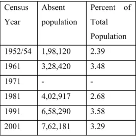
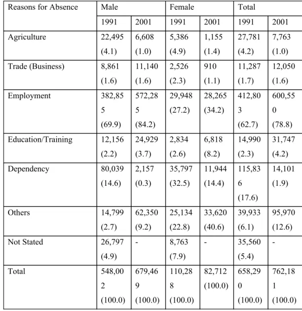
High population growth in Assam was thus soon to become an issue. In fifty years 190151 – the growth was 138 per cent. Crop production had also increased in this period, so had increased the area under cultivation, similarly tea production had increased; but all this compared to labour growth was a minor phenomenon to the besieged mind – be it farm labour, peasant labour, plantation labour, or labour in petty jobs. Typically, the protest of the native did not arise around the demand for jobs, but around issues of election, electoral rolls, franchise, and citizenship rights – it was a war against aliens. The citizens were prepared to rather remain economically impoverished, sick, and infirm, and survive on the doles handed out by the
“centre”, which logically along with the tea garden owners and timber merchants should have been an equally alien presence to the natives, but it was time that the citizens had to drive out the aliens, in view of the unnatural population growth in the state – by one count between 1961 and 1991 nearly one hundred per cent growth. Against illegal immigrants in one case, it was said that 64 per cent of the total number of cases of complaints out of a total electorate of 6,00,000 had been upheld. The figure of complaints upheld in this case was 45,000. The 10 bloody antiimmigrant movement continued for five years – not only foreign immigrants were attacked even members of the minority communities, particularly Muslims, were targets at times. Riots, torching of houses, looting, paralysing administration, civil disobedience – the war continued in all forms. War against foreigners became civil war amongst various communities. The State had to combine strong methods and persuasive techniques to administer interethnic relations, and demography became one more area of governmentality, so much so that defining an Assamese – the first task of claiming a nation – became an enterprise beyond cultural articulations, it was bloody, administrative, contentious, exclusive, expelling, and an elect enterprise. From the neat writings of Assam Sahitya Sabha to the killing fields of Nellie was but a short road. On surface it was a question of expelling or killing Muslims, at time Bengali Muslims at times Assamese Muslims, but at the level of the physicality of nationhood, it involved the plain tribes, hill tribes, other linguistic groups such as
9 Cited in Sanjib Baruah, India Against Itself – Assam and the Politics of Nationality (New Delhi: Oxford University Press, 1998), p. 67.
10 Sanjay Hazarika, Strangers in the Mist (New Delhi: Penguin, 1994), p. 138.
the Nepalese, and people from other states like Nagaland, Manipur, Tripura, or West Bengal, and Bihar. Many organisations grew up or gathered strength and momentum in selfdefence in this bloody and bloodless war, the most prominent being the United Minorities Front, which bagged 17 out of the state’s 126 Assembly seats in the Assembly elections of December 1985.
The ceding of Sylhet (in form of referendum) years back in the Great Partition, as could be seen now, had done little to make Assam a pure nation, even after it was cut off its (East) Bengal 11 links, for East Bengal in its different incarnations had sent in, in the words of the top ruler of Assam the Governor, Lt. General S.K. Sinha, hordes of people, in his exact words, “a silent and invidious invasion of Assam” causing the possible loss of the “geostrategically vital districts of Lower Assam”, “which would soon claim merger with Bangladesh”, “the driving force of which would be the international Islamic fundamentalism”. The spectre was severe – “Loss of Lower Assam will sever the entire land mass of the North East from the rest of India and the rich natural resources of that region will be lost to the nation”. 12
In this war cry, Acts proved to be of little use in expelling immigrants – the Foreigners Act or the Illegal Migrants Determination Tribunals Act. The figures told the story – in fifteen years after the Assam Accord, the total number of inquiries initiated against suspected illegal aliens was 3,02,554, and number of illegal immigrants expelled was 1,461. Because it was a war, all communities had developed strategic tools of linkages and enmities – plains/hills, valleys/hills, Hindus/Muslims, Bengalis/Assamese, Bengali Muslims/Bengali Muslims, Assamese Muslims/ Bengali Muslims, Bodos/Assamese, Bodos/Muslims, Bodos/Santhals, Assamese/Nagas, Assamese/Kukis, Karbis/Kukis, Karbis/Assamese…It was not a case of sudden ethnic conflict, it reflected rather a condition of generalised war, because the war consisted of several battles and theatres of attrition. Insecurity from migration had created lines of all kinds, and had taken clearly military dimensions. But of that later; first let us see little more how this condition engulfed areas outside Assam too.
11 Indeed, as historical research into the history of Sylhet referndum of 1947 bears out, the referendum by itself was the reflection of the fault lines within the Assam society. See, for instance, the essay by Bidyut Chakrabarty, “The ‘Hut’ and the ‘Axe’ – The 1947 Sylhet Referendum”, The Indian Economic and Social History Review, 39 (4), 2002, pp.317350.
12 “Report on Illegal Migration into Assam” submitted by the Governor of Assam to the President of India, 1998 – http://www.satp.org/India/Documents/Assam_Illegal,html
In Tripura long back in 187677 the indigenous people were more than two thirds of the total population of 91,759. More than hundred years later in 1991, they counted for less than one third of the state’s population of 2,757,205. It was again roughly the same story. The Maharaja of Tripura had enacted legislation in 1917 and 1925 to acquire land for tea cultivation, which encouraged migration. Moreover Bengali being the language of administration, immigration from East Bengal increased. Besides peasants, artisans also joined the golden trek driven from native land by recurrent famines, usury, and landlords’ oppression.
By 1930, the number of migrants had risen remarkably, and now for the first time land had to be reserved by measures decreed in 1931 and 1943 for the Tripuris, Jamatias, Reangs, Noatias, and the Halams. Massive internal displacements took place in the first half of the forties of the last century, when Reangs, the second largest indigenous community in Tripura, revolted against the Maharaja of Tripura and the movement was brutally suppressed. Reangs in large number left Amarpur and Udaipur in South Tripura and emigrated in thousands to the North, also towards the Chittagong Hill Tracts and the Lushai Hills. Thus Udaipur’s population remained almost stagnant between 1931 (Reang population 2151) and 1961 (Reang population 2374), while in the same thirty years the Reang population of Dharmanagar rose from 735 to 18,834. The population of Belonia similarly increased, while in Kailasahar it decreased from 11,218 to 6283. With the Great Partition began waves of migration in the state, and finally in 13 the eighties Buddhist Chakma refugees entered in sizeable numbers from the Chittagong Hill Tracts in the wake of the conflict there and army operations of the Bangladesh State against the rebellion. The Tripura Upajati Juba Samity (TUJS) was formed in 1967, it led in 1978 to the formation of the first militant movement against the immigrants, the Tripura National Volunteers, which soon started attacking settlers and symbols of government authority, including at times security forces. Land question became crucial, and with jhum cultivation being systematically disturbed and finally destroyed, clashes began to erupt. The June riots of 1980 were the first major signal of the troubled time. It caused enormous displacements. The Dinesh Singh Committee Report estimated that nearly 3,72,000 persons had been affected by the riots of whom about 1,50,000 people belonged to indigenous communities. Nearly 2,00,000 people had to be sheltered in camps. The number of total relief camps was 141; nearly 35,000 houses were gutted; and the estimated loss of property was about Rs. 21 crores. About 1300 people died. Again, in the last two years of the last decade an estimated number of 2614
13 Census of India, 1991, series 24, Tripura.
families were displaced from severely affected areas such Khowai, Sadar, and Bishalgarh subdivisions due to clashes. By 2000, the civilpoliticalmilitary movement of the indigenous people against the settlers or migrants had become so strong, that a ragtag combination of forces under the title of Indigenous People’s Front of Tripura won the elections to the 28member Tripura Tribal Autonomous District Council. The years of the eighties of the preceding century were marked with violence, largescale settlernative inter killings, army operations, rape of women by security forces and the militants, kidnapping, and increasing communalisation of the scene. Today one estimate says that in the nineties – from 1993 to 1999 a total of 1,018 persons were killed (656 nontribals and 362 tribals) and 2,001 persons were kidnapped (1,663 nontribals and 338 tribals). And then in two years, the succeeding years of 2000 and 2001, as many as 692 civilians were killed, plus 47 security forces personnel, and 87 militants also lost their lives. The TUJS demanded from the Government of India more 14 powers to the Autonomous District Council, barbed wire fencing of the entire length of the 856 km long boundary with Bangladesh, push back of immigrants who had arrived after 1971, and the introduction of the innerline permit system to enter the Tribal Council Area.
Clashes also began in enclaves claimed by Assam and Nagaland where each claimed that people from the other state had come in and inundated the area, in Mizoram Chins were severely discriminated, in Arunachal Pradesh the Chakmas remained noncitizens even after decades of assurance to the effect that they would become citizens, and in Manipur through the years of eighties and the nineties of the last century, something happened akin to what I had described in The Marginal
Nation, namely the emergence of broken villages along the WestBengal Bangladesh border (such as pure Muslim or pure Hindu villages) and the decline of mixed settlements. Here too, a silent process of purifying homelands had set in, the hills of 15 Manipur became pure Naga Hills or Kuki Hills. And, the frenzy of development activities in the entire region – construction of dams, roads, pipelines, power generating centres, or reserving forests – threw up new displaced, thus new migrants, new aliens, new ethnicities, and new threats.
14 Figures cited from Wasbir Hussain, “Bangladeshi Migrants in India: Towards a Practical Solution – A View from the Northeastern Frontier” in P.R. Chari, Mallika Joseph, and Suba Chandran (eds.), Missing Boundaries – Refugees, Migrants, Stateless and Internally Displaced Persons in South Asia (Delhi: Manohar, 2003), p.
138.
15 For some details, see Phanjoubam Tarapot, Bleeding Manipur (New Delhi: HarAnand Publications, 2003).
In the construction of the Umium hydroelectric project a large number of Khasis was displaced without any chance of resettlement. Later on similar projects caused massive displacements in Chandrapur, Namrup, and Bongaigaon in Assam. The Dumbur project displaced 5845 families (an estimated number of 40,000 people) in Tripura. Before that the Kaptai dam construction on the river Karnaphuli in the Chittagong Hill Tracts in Bangladesh had displaced Chakmas and Hajongs and forced them to move to India – and many of them decades later still lead a life of a “stateless community”. Similarly the oil industry did not 16 benefit the ousted population in Duliajan, Noonmati, Bongaigaon, Digboi, and Nazira. Paper mills came up in late seventies of the last century in Nowgaon and Cachar, land pressure increased, and the battle over resource like land became ferocious leading at times to bloodbath as in Nellie (1983). Karbi indigenous people were similarly affected. And the construction of an IIT campus in North Guwahati caused the displacement of 35,000 people. The media ( Amar Asom
, 2 September 2001) reported that out of the central grant of 10.3 crores of rupees to the state government to pay compensation, only 4.3 crores of rupees reached people. If the Tipaimukhi multipurpose project comes up in Manipur with an estimated cost of Rs. 2899 crores (1995 price level), it will submerge fully 16 villages and partly 51 villages affecting 15,000 people. The entire Tipaimukhi development plan presents in a congealed form the conflicts between the hill and the valley, state administration and the indigenous communities, and the ideology of development and the requirement of survival. Similar development awaits 17 Arunachal Pradesh with the two proposals of Siang dam and the Subansiri hydel project.Similarly in North Bengal, contemporary observers have noted, how dispossession of resources and displacement have played crucial role in the making of a political community and the movement for its claims. 18 The battle of resources has pitted communities against the State, the army against the people, one community against another, and in general has reconstructed relations.
16 On this see, Sabyasachi Basu ray Chaudhury, “Uprooted Twice – Refugees in the Chittagong Hill Tracts” in Ranabir Samaddar, Refugees and the State – Practices of Asylum and care in India, 19472000 (New Delhi:
Sage Publications, 2003), pp. 249280.
17 For details on displacement due to development activities, Monirul Hussain, “State Development and Population Displacement in Northeast India” in C.J. Thomas (ed.), Dimensions of Displaced People in Northeast India (New Delhi: Regency Publications, 2002), hereafter DDP, pp. 282298; Monirul Hussain,
“State, Identity Movements and Internal Displacement in Northeast India”, Economic and Political Weekly, 35 (51), 2000; Hiram A. Ruiz, Northeast India’s Hidden Displacement, report of the U.S. Committee for Refugees, Washington D.C., 2000.
18 Sujata D. Hazarika, “Dispossession and Displacement – The Genesis of a People’s Movement in North Bengal”, DDP, pp. 299315; also Soumen Nag, ...
In such restructured scenario, Manipur presents a grim scenario of the battles for survival; in fact it presents what I have described earlier as the condition of generalised war. In 1891 the Union Jack was hoisted over Imphal, and the era of British paramount power began after the British army defeated stiff Manipuri resistance. Colonial rule began with executing a prince and a commander of the resisting army. Other leaders were sent to Alipur jail in Calcutta. The valley remained under the reinstituted princely rule, which was now severely limited in power, and the hills were to be from now administered by the political agent based in Imphal. The Manipur State Durbar (MSD) formed under the “Rules for the general Administration of the State” (RFGAS) framed by the Government of Assam was to oversee the daily administration, and the MSD had to follow the political agent’s advice. Though the colonial desire of full annexation was not put in practice, by all accounts Manipur as an independent state with its political capacity to negotiate and solve its problems had passed into a myth. Again slavery and forced labour for the royalty became issues for the colonial power to discipline the native administration. However, while the reform to abolish slavery and forced labour were welcomed, protests and resistance against colonial interference and indirect rule continued. The British reserved some area for its direct rule; most of the hill areas though formally ruled by the Maharaja, the president of the MSD, was from now on administered by an ICS officer and other officers belonging to the Assam Civil Service, and thus the political agent of the Assam government was the real administrator. The hills and the British reserve area were placed under different sections of the RFGAS. With administrative reorganisation in the twenties and early thirties in the State, tribal conflicts flared up again. War between Kukis and the Nagas started. Three subdivisions were created: (a) The sadar subdivision comprising the “hillmen” living in the valley and in the hills bordering valley besides certain other areas, the area to be directly administered by the president of the MSD; (b) the Tamenglong subdivision covered the hills on the western side of the state, and was inhabited mainly by the Kabuis and other Nagas, and Kukis; (c) the Ukhrul subdivision covered the hills on the eastern side of the state, inhabited by mainly the Tangkhuls, Kukis, and others. The colonial power also encouraged Kuki settlements and other settlements in other areas. A new sense of territoriality emerged in the entire area with the British policy of divide and rule, modern administration, indirect rule, court system, and bureaucracy. Intercommunity clashes began in 1890s. In 1892, some “286 persons were massacred” (Nagas by Kukis), in 1918 Kukis wiped out “a Kabui village”, in the same year in another incident “76 heads” of Kabuis were taken away by
invading Kukis, and 20 villages were destroyed. Kukis from Burma joined the Kukis of the area in this war between the settlers on the frontier of the hill areas and the indigenous Nagas who lived deep inside the hills. Nagas also ravaged Kuki villages – in 1880 the first attack on the Kukis had taken place, in which “20 men, 7 boys, and 25 women and girls had been killed”, and several others were found missing. Several hundred fled. At time Manipuri outposts were attacked as they were seen to be favouring the Kukis. The Kukis also protested against conscription in the First World War and the British had to mount a pacification campaign, in which about 200 Kuki villages were burnt down. Meanwhile Kukis took away “200 heads” of Nagas in an attempt to settle old scores. About 2000 “hillmen”, principally Kukis, were conscripted for the campaign in France, but Kukis resisted any further conscription and raided villages of those groups/tribes that did not resist the conscription. British military operations began to impose order in the hills. Columns of Assam Rifles marched against rebellious Kukis.
One of the eleven Kuki chiefs was killed; ten others were captures and sent away to different jails. The Kuki rebellion had been settled, but only to be replaced now by Kabui rebellion (193031). The Kabuis wanted to make war on the British and the Kukis, who symbolised diseases, famines, taxes, and forced labour for the British. A messiah king was to be instituted after the rebellion was successful. Kukis were attacked, Manipuri traders were raided, but the movement failed after the capture of two leaders Jadonang and then Gaidinliu. NagaKuki feud continued; also continued the confrontation with the British.
In the entire period of fifty years before 1947, disturbances in the hills created deaths and displacement, and it is important to remember these early years to understand the nature of the relation between migration and conflict today in Manipur. By the time independence and Manipur’s “merger” with independent India came, the state was ready for a general war.
Following Hijam Irabot’s dream, many Manipuris (mainly Meiteis) got organised in their rebellious armies, so got organised the Kukis, and the Nagas firmly cast their lot with the main rebellious Naga organisation. According to one report, by the end of the century, that is with the passage of another fifty years, there were about 12 militant organisations, in all 19,590 warriors, about 10,000 units of small arms, and nearly one lakh active sympathisers to various wellentrenched rebellious causes. 19 As usual army depredations have only worsened the situation. Demands on issues ranging from independent Manipur to separate homelands or to
19 The citations are from various state records referred to in Bleeding Manipur, pp. 139178.
unification with nation have persisted. Army operations have resulted in further killings, torture, violence on women, large scale displacements, and an over all unqualified political disaster as a result of the Indian government’s strategy to step in the colonial policy of provoking “tribal feuds”, occupy, suppress, and rule. What the British could get away with is not possible today. In this violent situation, humanitarian catastrophe is now permanent. With no dialogue in sight, there is no end to the catastrophe also in sight.
Interests in Manipur thus remain in conflict. The people, mainly Meiteis, do not want that the Sixth Schedule be extended to the hills, giving at least partial autonomy to the hills and the hill communities. On the other hand the move to extend the Manipur Land Revenue and Land Reforms Act of 1960 has been opposed in the hills because it is seen as an attempt to take away the inalienable rights of the people to their land. Because areas in the state remain mixed, the plan that could have satisfied many – a neat segmentation of the territory according to demographiccultural lines – remains impossible or at least extremely difficult. In the ten years period of 195666, nearly 60 Kuki villages were destroyed in Tamenglong and Ukhrul districts.
In the 1990s about an estimated 500 people were killed in KukiPaite conflict, about 90 villages were burnt down, and about 2,25,000 people were displaced. Similarly conflict has flared up around the issue of converting the Sadar Hills subdivision into a fullfledged North District, renamed Senapati district. Nagas there do want that this becomes a revenue district, claiming that the area belongs to them, the Kukis are equally insistent on their demand for the district. In the early years of 1990 the United Naga Council served notice on the Kukis to leave the Naga Hills because the Kukis they alleged were being encouraged and supplied with arms by the government. From 1970 to mid 1990s thus clashes continued with intermittent killings, burning of villages, and displacements of people – all in all a persistent humanitarian crisis, of which a full account can be constructed only through a very diligent microhistory of the conflict there.
The claim of the Nagas there that they belong to the Naga nation whose people and area are historically spread to parts of other states besides the state of Nagaland has not still not found any ground of reconciliation with other competing claims. Notwithstanding the nature of the ethnic claims, one can note in this context the rough pattern of “ethnic landholdings” in the hills of Manipur: In Churachandrapur district Kukis hold 90 percent of the landholdings, Nagas 10 per cent; in Chandel Kukis hold 75 per cent, Nagas 25 per cent; in Senapati Kukis hold 25 per cent, Nagas 75 per cent; in Tamenglong Kukis have 30 per cent and Nagas 70 per cent; and in Ukhrul again the division is roughly the same. More than 7,000 Nagas were displaced in the