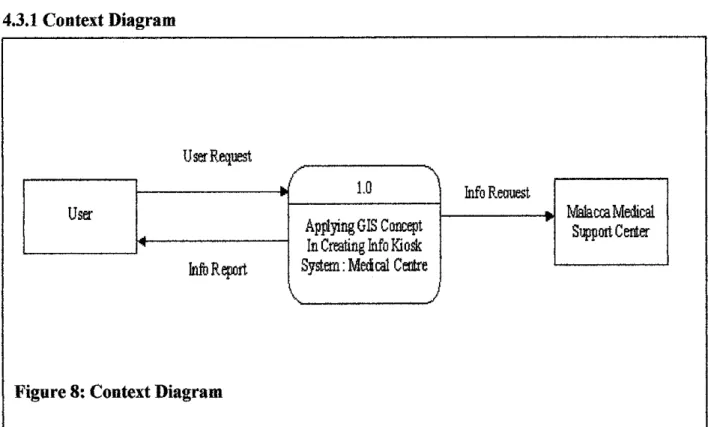
This project dissertation report was titled Application of GIS Concept in Creation of Info Kiosk: Medical Center, System should be implemented as server side client method. The system helps people by using devices to guide them to find their way to the location or destination they want to go. The system will respond to verbal instructions so that people can easily find their way to the hospital.
The system responds verbally to instructions so people can easily find their way to the hospital. Apart from that, using the latest technology to build the system can also help bring the system to market. For this type of risk, a complicated and tough security development must be applied to the system, so that the risk of the system being hacked is reduced.
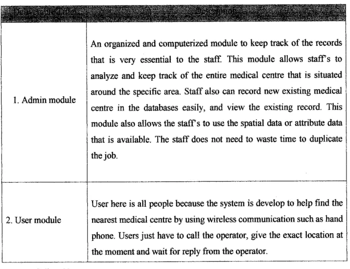
The risk of the system being hacked by hackers depends on the security the systems provide. Users here are all people, because the system is developed to help find the nearest medical center using wireless communication, such as mobile phone.
Applying GIS Concept In Creating Info Kiosk: Medical Centre
GEOGRAPHIC INFORMATION SYSTEMS AND ITS HISTORY
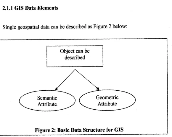
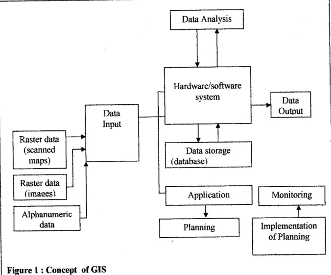
GIS-geographic information system is an information technology that collects, stores, analyzes, arbitrarily acquires, transforms and displays spatial data from the real world for a specific set of purposes. GIS references real-world spatial data elements, also known as graphical or feature data elements, to a coordinate system. Examples of spatial data functions are latitude, longitude, and national plane, which refer to a specific plane on earth.
Spatial data and descriptive attributes in the same coordinate system can be layered together for mapping and analysis. The two most popular types of spatial data are raster and vector, Raster refers to spatial data according to a grid of cells or. Through a function known as visualization, a GIS can be used to produce images, not just maps, but drawings, animations, and other cartographic products.
The state of the Earth's surface, atmosphere and subsoil can be investigated by loading satellite data into a GIS. For example, the changes in vegetation vigor through the growing season can be animated to determine when drought was most extensive in a particular region.
METHODOLOGY
- In the integration and system-testing phase all the program units are integrated and tested to ensure that the complete system meets the software requirements
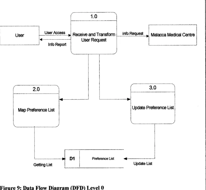
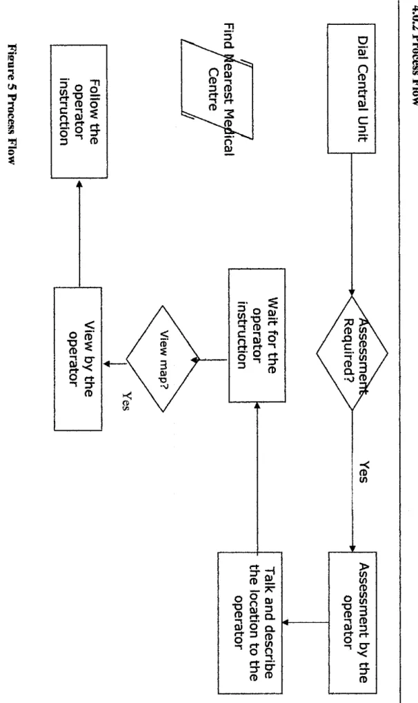
Users can call the central number to seek assistance from the operator in finding the shortest and safer routes, finding the current traffic situation and the nearest public transportation to go to the hospital or medical center. Users must tell the operator his/her location so that the operator can find the user's exact location and the nearest hospital or medical center before the operator can provide them with the information to follow. The users must wait for the operator to check the information provided by the users with the system to recognize the exact location of the people and the nearest hospital or medical center.
Users must follow the instructions given by the operator to guide them safely to the nearest hospital or medical center. All the instructions allow the users to know the latest information about the types or the nearest public transport location, geographic location for the hospital or medical center, the shortest and safer routes to go to the hospital or medical center, the current traffic. condition and measure the distance from the standing point to the hospital places. source: http://scitec.uwichilledu.bb/cmp/online/waterfall_modelhtm). To get a clear picture of what the title was about and what it looked like, the author surfed the internet and found some examples similar to the system.
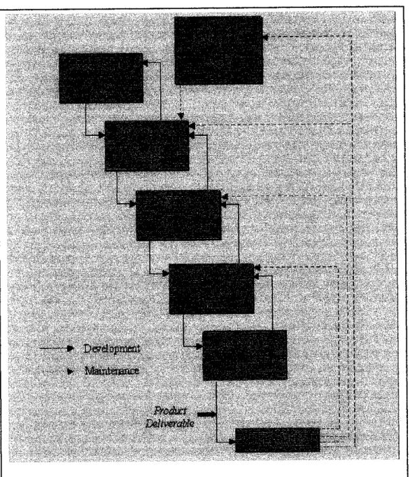
In general, the system was implemented by the Waterfall model method according to System Developments Life Cycle (SDLC). In the specification phase, the system specification is produced from the detailed definitions above. In the system and software design phase, the system specifications are translated into a software representation.
Hardware requirements are also defined at this stage along with a view of the overall system architecture. Testing in this phase focuses on ensuring that errors are identified and that the software meets its required specifications. In the system integration and testing phase, all program units are integrated and tested to ensure that the complete system meets the software requirements. and tested to ensure that the complete system meets the software requirements.
However, many projects rarely follow the sequential flow due to the inherent problems associated with the rigid format, as noted below: Because the customer usually has only a vague idea of what exactly is required from the software product, this model has difficulty accommodating of the natural uncertainty that exists at the beginning of the project. So that when the blind person tells the operator in charge where exactly he/she is, the operator will give the blind person the direction where the nearest hospital or clinic is where he/she can go.
Applying GIS Concept in Creating Info Kiosk: Medical Centre
Applying GIS Concept in Creating Info Kiosk : Medical Centre
Here is the log in page that authenticate user according to their usemame and
Here shown that the log in page need a valid user name and password as registered and provide from system administrator, thus if is not bekey in correctly a pop-up message
Blind people • visit the health care unit after using this system as a trauer before. For the next GTS, It is being formed and we will set up the possible Government Hospital, larger clinics, private hospitals and private clinics throughout Malaga. Web-based QIS for integrated wireless LANs for Telemedicine focuses primarily and exclusively on the blind and visually impaired. Blind people who want to find the nearest health care facility from their country can use this system like the latest ones before.
For the web-based GIS, we only focus on Malacca and we list all possible public hospitals, public clinics, private hospitals and private clinics around Malacca.
Next, showed the correct way to enter user name and password for accessing the main
The general page works as information site that mostly tells about either objectives or
Ptaata afiabla JavaScript for Brotfier Othnrwm Vou wouldn't be able to Uu the Ssrtem. Please make sure your Brouie'r is configured to accept 'CooJoas', 2, Please get JavaScript working for your BroKiar.
Here show map that have been placed with medical allocation and attribute database
Here shown the pop-up script that occurs when you click onone of thelabel or icon
- Log out
1. Make sure four Brounr are configured to accept "CoedHS", 2. Pleesa anablH3snMScriptfbr your browser. Please enable JteiaScript for your browser, otherwise you will not be able to use the system. 14) This is the part where the system could give the right knowledge of the chosen medical center that is the best and most preferred for each patient surveyed.
Mahkota Medical Center Melaka is a private medical center EtragJcaHy located in the main business district and tourist area of Melaka. Mahkota Medical Center Melaka was launched in September 1994 with the main objective of providing an accessible, affordable and acceptable tertiary healthcare for the people. Makaota Medical Center offers one-stop comprehensive patient care supported by diagnostic radiology and t&mcal laboratory facilities.
A large number of foreign patients from neighboring countries (Brunei and Indonesia) come to Mahkota Medical Center to be examined3 and treated. .. 15) Here is the example when you click on one of the four icons on the medical information page. Here is the main page of the update which consists of two options which are insert and edit. P1a«s* erl*bl* JavaScript for vour Bro«ii«r Otherwise you wouldn't be able to use the system.
Please enable JavaScript for your browser, otherwise you would not be able to use the system. Stability The system must be stored in a secure and stable web server to ensure constant user connectivity and interoperability. By using this GPS, the operator using the site can automatically know without asking where people are at that moment.
As far as care is concerned, no one has established and developed a system in Malaysia. Effective and successful approaches are used in the development process of this project to ensure the success of using the GIS concept in the creation of an information kiosk: a medical center. The system consists of web-based GIS application services that provide a better and simpler map assignment site for the medical center.