Ear thquake Science in Malaysia
Status, Challenges and Way ForwardFELIX TONGKUL
FELIX TONGKUL
INAUGURAL LECTURE SERIES
7
INAUGURAL LECTURE SERIES7
PENERBIT UNIVERSITI MALAYSIA SABAH Kota Kinabalu • Sabah • Malaysia
http://www.ums.edu.my 2020
Felix Tongkul
Delivered as Universiti Malaysia Sabah Professorial Inaugural Lecture on 18 November 2020 via live streaming on Universiti Malaysia Sabah Facebook
stored in a database or retrieval system, or transmitted, in any form or by any means, electronics, mechanical, graphic, recording or otherwise, without the prior written permission of Penerbit Universiti Malaysia Sabah, except as permitted by Act 332, Malaysian Copyright Act of 1987. Permission of rights is subjected to royalty or honorarium payment.
Penerbit Universiti Malaysia Sabah makes no representation – express or implied, with regard to the accuracy of information contained in this book. Users of the information in this book need to verify it on their own before utilizing such information. Views expressed in this publication are those of the author(s) and do not necessarily reflect the opinion or policy of Universiti Malaysia Sabah. Penerbit Universiti Malaysia Sabah shall not be responsible or liable for any special, consequential, or exemplary problems or damages resulting in whole or part, from the reader’s use of, or reliance upon, the contents of this book.
Perpustakaan Negara Malaysia Cataloguing-in-Publication Data Felix Tongkul, 1960-
Earthquake Science in Malaysia: Status, Challenges and Way Forward/
Felix Tongkul.
(INAUGURAL LECTURE SERIES; 7) Mode of access: Internet
eISBN 978-967-2166-85-6 1. Earthquakes--Malaysia.
2. Natural disasters--Malaysia.
3. Seismometry.
4. Government publications--Malaysia.
I. Title. II. Series.
551.2209595
Typeface for text: Times New Roman Text type and leading size: 11/13.2 points Cover and layout designer: Nataniel Ebin
Proofreader: Marshell Kanam Gombor
Editor: Lindsy Lorraine Majawat
Published by: Penerbit Universiti Malaysia Sabah Tingkat Bawah, Perpustakaan Universiti Malaysia Sabah Jalan UMS
88400 Kota Kinabalu, Sabah Printed by: Percetakan Keningau Sdn. Bhd.
Lot 26, Phase 1, HSK Industrial Centre, km 8 Jalan Penampang, 88300 Kota Kinabalu, Sabah.
ACKNOWLEDGEMENTS vii
SYNOPSIS x
SINOPSIS xi
INTRODUCTION 1
EARTHQUAKE SCIENCE PRIMER What is an Earthquake?
What Causes an Earthquake?
What are the Different Types of Faults?
What is an Active Fault?
How are Earthquakes Recorded?
What Determines the Size or Magnitude of an Earthquake?
What is the Difference between Magnitude and Intensity?
How does Local Geology Affect Shaking?
How are the Likely Size and Frequency of Future Earthquakes Estimated?
What is Seismic Hazard and How is it Measured?
What is Involved in a Seismic Hazard Assessment?
What is Probabilistic Seismic Risk?
2 3 3 6 7 8 13 14 15 16 17 18 19 STATUS OF EARTHQUAKE SCIENCE IN MALAYSIA Plate Tectonic Movements around Malaysia
Earthquake Hazards in Malaysia
Potential Source of Regional Earthquakes Potential Source of Local Earthquakes Impact of Earthquake in Malaysia Earthquake Vulnerability in Malaysia Mitigation of Earthquake in Malaysia
19 20 21 31 34 47 63 65 CHALLENGES IN EARTHQUAKE SCIENCE IN MALAYSIA
Lack of Seismic, Geological, Geodetic and Engineering Data Insufficient Seismic and Geodetic Monitoring System Lack of Trained Human Resource
Lack of Public Awareness
74
75 76 78 78
Comprehensive Geological and Engineering Studies Coordinated Seismic and Geodetic Monitoring Human Resource Capacity Building
Coordinated Public Education
Special Research and Development Fund National Earthquake Research Centre
79 80 80 81 81 82
CONCLUDING REMARKS 82
REFERENCES 83
APPENDICES Appendix 1 Appendix 2 Appendix 3
89 89 92 93
BIODATA 96
I
would like to place on record my heartfelt thanks to all those who in some way or other helped me in my career path leading to the inaugural lecture. I am grateful to Prof. Datuk Dr D. Kamaruddin D. Mudin, former Vice Chancellor of Universiti Malaysia Sabah, for his support in my research and for inviting me to deliver this inaugural lecture. My gratitude also goes to Professor Datuk Dr Taufiq Yap Yun Hin, Vice Chancellor of Universiti Malaysia Sabah for his administrative support to hold this inaugural lecture.I am also grateful to the former Vice Chancellors, Tan Sri Prof.
Datuk Seri Panglima Dr Abu Hassan Othman, Prof. Emeritus Datuk Dr Mohd Noh Dalimin, Prof. Datuk Seri Panglima Dr Kamaruzaman Ampon and Prof. Datuk Dr Mohd Harun Abdullah, who supported my professional development and encouraged my research activities.
My gratitude also goes to Prof. Dr Shahril Yusof, former Deputy Vice Chancellor (Research and Innovation) for his strong support in my research on natural disaster, especially on earthquake science. My gratitude also goes to Associate Professor Dr Ramzah Dambul, Deputy Vice Chancellor (Research and Innovation) and his very supportive administrative and financial staff at the Centre for Research and Innovation Management (PPPI).
I am thankful to the editorial committee headed by Prof. Dr Rasid Mail, Deputy Vice Chancellor (Academic and International) and the committee members, Prof. Dr Sharif A.K. Omang, Prof. Dr Kawi Bidin, Prof. Dr Ismail Ibrahim, Prof. Dr Vincent Pang Ah Fook and Assoc. Prof. Dr Asmiaty Amat for reviewing the manuscript. I also want to thank the staff of Penerbit UMS, namely Ms Lindsy Lorraine Majawat, Mr Marshell Kanam Gombor, Ms Dora Diana Desmond and Mr Nataniel Ebin for facilitating its publication.
I am grateful to the two internal evaluators, Prof. Dr Sanudin Tahir and Prof. Dr Sharif A.K. Omang, and three external evaluators, Prof. Dr Ir. Azlan Bin Adnan from Universiti Teknologi Malaysia, Prof. Dr Azman Abd Ghani from Universiti Malaya and Prof. Dr Ir. Taksiah Binti A. Majid from Universiti Sains Malaysia who provided positive and constructive comments on the manuscript.
Registrar, for facilitating this inaugural lecture.
I am grateful to Prof. Dr Baba Musta, Dean of the Faculty of Science and Natural Resources, Dr Rozaimi Zakaria, Deputy Dean (Academic and International), Dr Darmesah Gabda, Deputy Dean (Student Affairs and Alumni) and Dr Mohd Sani Sarjadi, Deputy Dean (Research and Innovation) for the support and cooperation provided in organising this inaugural lecture. I am also grateful to members of the inaugural lecture organising committee, headed by Prof. Dr Baba Musta for their hard work and efforts.
I am grateful to all the academic, managerial and administrative staff of the Faculty of Science and Natural Resources for their cooperation. I would like to show appreciation to Dr Zulhery Isnain, Head of Geology Programme and former heads, Dr Hennie Fitria W. Soehady Erfen, and Ms Hazerina Pungut for their support in academic matters.
I am grateful to my colleagues at the Geology Programme, Prof. Dr Sanudin Tahir, Prof. Dr Shariff Abd Kadir Shariff Omang, Prof. Dr Sahibin Abd Rahim, Dr Ismail Abd Rahim, Dr Junaidi Asis, Mr Mohamad Ali Yusof Mohd Husin and Mr Hardianshah Saleh for their continuous support in academic and research matters. I also want to thank our assistant research officers, Mr Jalaludin Majalip and Mr Sanin Bin Awang, for their assistance in the field and in the laboratory.
I also wish to acknowledge all my research fellows at the Natural Disaster Research Centre for their support and cooperation in my research initiatives. Assoc. Prof. Dr Rodeano Roslee, Deputy Director, provided exemplary cooperation and support together with Prof. Dr Baba Musta, Assoc. Prof. Dr Justin Sentian, Assoc. Prof. Dr Ejria Saleh, Assoc. Prof.
Dr Muhammad Idris Bullare @ Hj. Bahari, Dr Ismail Abd Rahim, Dr Carolyn Melissa Payus, Dr Norazlina Khamis, Dr Noor Sheena Herayani Harith and Dr Hennie Fitria Wulandary Soehady Erfen. Meanwhile, Ms Eldawaty Madran, Ms Halleyaty Jackarullah, Mr Juhaidi Jumaring and Ms Lindah Mathahir provided administrative support.
I also wish to acknowledge the contribution of my current and past research assistants and postgraduate students at the Natural Disaster Research Centre, who assisted me in my research. Special
Fui Khiong, Ms Kaoy Mei Ching, Mr Wong Fui Peng, Mr Louvis Ferrer Jefree, Mr Joanes Muda, Mr Fredolin Javino, Mr Daulip @ Dee L. Lakui, Ms Zulfadzilawati Senin, Ms Faye Isidore, Mr Watin Malun, Mr Andryno Payer, Mr Jonathan Duasing, Mr Edgar Jr. Joe and Mr Chung Wei Kiat.
I would like to acknowledge the contributions of the Department of Mineral and Geoscience Malaysia [Jabatan Mineral dan Geosains Malaysia (JMG)] in Sabah and the Malaysian Meteorological Department (MetMalaysia) for sharing their geological and seismic data, respectively. Special mentions are due to Mr Paulus Godwin, Mr Alexander Yan Sze Wah, Mr Jontih Enggihon, Mr Mohd Yusop Ramli, Dr Frederick Tating and Mr Bailon Golutin from JMG and Dr Mohd Rosaidi bin Che Abas, Mr Saw Bun Liong and Dr Chai Mui Fatt from MetMalaysia for their strong support and cooperation.
I wish to acknowledge all my co-researchers and co-authors of my publications. I would like to thank all my research collaborators on earthquake science in Malaysia from Universiti Malaysia Sabah (UMS), Universiti Malaya (UM), Universiti Kebangsaan Malaysia (UKM), Universiti Teknologi Malaysia (UTM), Universiti Sains Malaysia (USM), Nanyang Technological University (NTU), University of London, University of Cambridge and University of Aberdeen for their valuable contribution to my research knowledge and experience.
I would like to record my gratitude to my friend, colleague and co-researcher, Prof. Dr Marcus Jopony, who have been very supportive of my research on earthquake in Sabah.
I wish to record my deepest appreciation to my wife, Anne, son, Jubili and daughter, Junia for their undivided support in my professional career. Special thanks to my parents, siblings and in- laws for their prayers and moral support.
Lastly, I wish to dedicate this lecture to all the families who lost their loved ones during the 2015 Ranau Earthquake. I hope that such episodes will not be repeated again in the future.
E
arthquake hazard is regarded as low throughout Malaysia, with the exception of Sabah where it is considered moderate.This elevated level of hazards was reinforced on 5 June 2015 when a magnitude 6.0 Richter Scale (Mw) earthquake struck Ranau, killing 18 climbers on nearby Mount Kinabalu. Despite this and other recent sizeable earthquakes, seismic hazard in Malaysia is poorly understood, yet the population is increasing and growth in buildings and infrastructure is rising. In the face of such rapid expansion, it is crucial that earthquake hazard is properly quantified in order to minimize future risk. The science of earthquake that deals with a scientific understanding of earthquake processes, their consequences and mitigation need to be constantly improved. This lecture highlights the level of earthquake hazard in Malaysia, the challenges in mitigating earthquake hazards and the way forward to strengthen earthquake science in Malaysia. Based on the 2015 Ranau earthquake experience, it is clear that we still have a long way to go in mitigating earthquake hazard in Malaysia. There is an urgent need to carry out comprehensive geological, geotechnical and engineering mapping of earthquake-prone areas and to carry out coordinated monitoring of earthquake events and crustal plate movements. Such tasks require planned human resource capacity building by related government agencies and universities, and the allocation of special research and development grant. Ideally, these tasks should be coordinated by a national earthquake research centre.
Apart from the rigorous scientific activities, a coordinated public education programme on earthquake hazards and preparedness should be intensified and carried out continuously.
SYNOPSIS
B
ahaya gempa bumi di seluruh Malaysia dianggap sebagai rendah kecuali di Sabah di mana ia adalah sederhana.Peningkatan tahap bahaya ini diperkukuhkan oleh kejadian gempa bumi bermagnitud 6 Skala Richter (Mw) yang melanda Ranau pada 5 Jun 2015 di mana 18 pedaki Gunung Kinabalu terkorban. Walaupun kejadian gempa bumi ini dan begitu juga dengan beberapa kejadian gempa bumi lain bermagnitud sederhana yang berlaku kebelakangan ini, pemahaman bahaya gempa bumi di Malaysia masih rendah sungguhpun bilangan penduduk meningkat dan bangunan infrastruktur terus berkembang. Dalam berhadapan dengan pembangunan yang sangat pesat ini adalah sangat penting agar bahaya gempa bumi diukur secara terperinci untuk mengurangkan risiko pada masa hadapan. Sains gempa bumi yang merangkumi pemahaman saintifik berkaitan dengan proses gempa bumi, impak serta mitigasinya perlu sentiasa dipertingkatkan. Syarahan ini akan menekankan tahap bahaya gempa bumi di Malaysia, cabaran yang dihadapi untuk mengurangkan kesan gempa bumi dan bagaimana memperkukuhkan sains gempa bumi di Malaysia. Berdasarkan pada kejadian gempa bumi di Ranau pada 2015, agak jelas bahawa kita masih mempunyai perjalanan yang jauh untuk mengurangkan bahaya gempa bumi di Malaysia. Terdapat keperluan mendesak untuk menjalankan pemetaan geologi, geoteknik dan kejuruteraan yang komprehensif bagi kawasan yang kerap dilanda gempa bumi serta membuat pemantauan kejadian gempa bumi dan pergerakan plet bumi yang terselaras. Tanggungjawab tersebut memerlukan pembangunan kapasiti sumber manusia yang terancang oleh agensi-agensi kerajaan dan universiti-universiti yang berkaitan serta peruntukan khas dana penyelidikan dan pembangunan. Secara idealnya, tanggungjawab ini boleh diselaraskan oleh pusat kajian gempa bumi kebangsaan. Selain dari mempergiatkan aktiviti saintifik, program pendidikan awam berkaitan bahaya gempa bumi dan persediaan untuk menghadapi gempa bumi perlu dipertingkatkan dan dianjurkan secara berterusan.
INTRODUCTION
E
arthquake science deals with the scientific understanding of earthquake processes (origin and properties), their consequences and mitigation. Earthquake science encompasses the multidisciplinary field of geology, geodesy, rock mechanics and physics of complex system apart from seismology.The main goal of earthquake research is to learn how to predict the behaviour of earthquake systems. The prediction has come to mean the accurate forecasting of time, place, and size of specific large earthquakes, ideally in a short time to allow nearby communities to prepare for a calamity. Unfortunately, accurate prediction of an earthquake is still not possible at this stage due to the complexity of earthquake systems. No clear signals before the occurrence of a large earthquake have been identified.
Felix Tongkul
Faculty of Science and Natural Resources Universiti Malaysia Sabah
However, many aspects of earthquake behaviour can be anticipated with enough precision to be useful in mitigating risk.
The potential of near-surface faults to cause future earthquakes can be assessed by combining geological field studies of the previous slippage with seismic and geodetic monitoring of current activity.
Seismologists are learning how geological complexity controls the strong ground motion during earthquakes, and engineers are learning how to predict the effects of seismic waves on buildings, lifelines, and critical facilities such as large bridges, dams and nuclear plants. Together, geologists, seismologists and engineers have quantified long-term expectations for potentially destructive shaking in the form of seismic hazard maps.
Earthquake science in Malaysia is still in its infancy and exploratory stage. Geologists, seismologists and engineers are talking to each other only recently, when “forced” to produce a seismic hazard map of Malaysia. Thus, opportunities for research in the field of earthquake science in Malaysia are wide open.
This lecture highlights the current status and challenges in earthquake science in Malaysia and proposes some strategic plans to strengthen earthquake science in Malaysia. It is hoped that some of these plans can be the basis for disaster risk reduction (DRR) programme on earthquakes in Malaysia.
EARTHQUAKE SCIENCE PRIMER
I
n this section, a brief introduction of earthquake science is provided to explain how and why an earthquake happens, how to measure its strength, and how to estimate the hazards associated with the earthquake.What is an Earthquake?
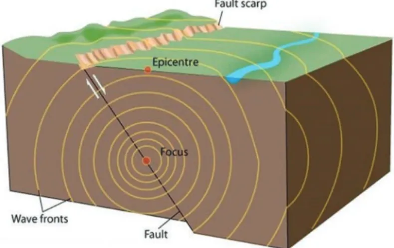
An earthquake is a vibration, sometimes violent, of the Earth’s surface that follows a release of energy in the Earth’s crust. This energy can be generated by a sudden slip on a fault or fracture on the Earth’s crust. During the sudden slip, vibrations called “seismic waves” are generated. These waves travel outward from the source of the earthquake along the surface and through the Earth at varying speeds depending on the material through which they move (Figure 1). Some of the vibrations are of high enough frequency to be audible, while others are of very low frequency. These vibrations cause the entire planet to quiver or ring like a bell.
(Image: Copyright of University of Waikato)
Figure 1 Vibrations called seismic wave generated by a sudden slip on the fault
What Causes an Earthquake?
An earthquake can be caused by tectonic plate movement, volcanic eruption, giant landslide or man-made explosion. Most destructive earthquakes, however, are caused by tectonic plate movements.
Tectonic plates represent the outer layer of the earth. The internal
structure of the Earth is layered in spherical shells: an outer solid crust, a highly viscous mantle, a liquid outer core that is much less viscous than the mantle, and a solid inner core (Figure 2).
(Image: Copyright of BBC)
Figure 2 Internal structure of the earth showing the four layers
The tectonic plates, consisting of the solid crust and upper mantel, known as lithosphere are roughly 100 km thick and consist of two principal types of material: oceanic lithosphere and continental lithosphere. Convection currents within the Earth’s mantle drive plate movements (Figure 3). Tectonic plates are like pieces of a puzzle of different sizes, floating on top of the mantle.
There are 9 major plates that move slowly relative to each other, they collide with each other at subduction zones, moves in a different direction at the mid-oceanic ridge and pass each other at transform fault (Figure 4). Plate movements cannot be felt by human because of its extremely slow movement, around 1 – 10 cm/year. Tectonic plates can be destroyed at a subduction zone and new tectonic plates generated at mid-oceanic ridge zone.
(Image: Copyright of Ohio State University)
Figure 3 Convection currents in the mantle move the plates as the core heats the slowly-flowing upper mantle
(Image: Copyright of Bucknell University)
Figure 4 Major plate movements. Notice that Malaysia is within the Eurasian Plate
Although tectonic plates are constantly moving relative to one another, their edges are usually locked together by friction, causing stress to build up along the plate boundaries. For example, where tectonic plates are colliding with each other, the plate boundaries comprise many individual features known as faults, each of which separates different blocks of the Earth’s crust (Figure 5). Eventually, the frictional strength of one or several faults is overcome and the blocks on either side of the fault move suddenly, with the built-up energy released as an earthquake.
Figure 5 Schematic of plate boundary where two plates (A and B) are colliding.
Earthquakes are generated along thrust fault planes in the rupture zone within Plate B
During a single earthquake, a section or ‘patch’ of Fault 1 or Fault 3 can slip tens of metres, while the rupture can extend for up to several hundred kilometres along the fault. The rupture can be several square kilometres in area. Earthquakes typically last for a few seconds to a few minutes, but the time between earthquakes on a single fault – sometimes called the ‘recurrence interval’ – can range from a few years up to tens of thousands of years.
What are the Different Types of Faults?
The interaction of the tectonic plates can produce horizontal force such as compression, extension or shearing on the earth’s crust.
There are three different types of faults – normal fault, thrust fault and strike-slip fault (Figure 6). Normal fault form due to extension along the mid-oceanic ridge, thrust fault due to compression along subduction zones and strike-slip fault due to shearing along transform faults. All three can produce an earthquake.
Figure 6 Three types of faults associated with extension and compression
What is an Active Fault?
Active faults are defined as linear areas where ground movement occurs systematically and continuously over a large area. Faults are commonly considered to be active if there has been movement observed or evidence of seismic activity during the last 10,000 years (Holocene age). Active fault movements are usually manifested on the Earth’s surface as a scarp, facet, sag pond, linear ridge, shutter ridge, linear valley and offset drainage channel (Figure 7). River incision and triangular facet indicate continuous vertical movement.
The presence of persistence landslides, damaged roads and mud volcanoes are other indicators of active fault movements.
(Source: Vedder & Wallace, 1970)
Figure 7 Geomorphological features associated with active fault movements
Active faults provide concrete evidence that a region is still undergoing tectonic stress. Active faults are a potential source of earthquakes. The larger the fault displacement the bigger the earthquake generated. Active faults thus play a very crucial role in the development of a seismic hazard map. When active faults have not been adequately mapped (e.g. unknown slip rate movement) they can be referred to as potential active faults.
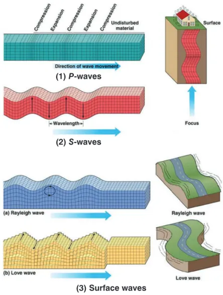
How are Earthquakes Recorded?
During the sudden movement on a fault, two different types of seismic waves are generated: body waves called P-waves and S-waves, and surface waves called Raleigh wave and Love wave (Monroe & Wicander, 2001). The speed of the waves depends on wave type and the properties of the rock; the denser the rock, the faster the waves travel. In the Earth’s crust, P-waves travel at around 6 – 7 km/s, while S-waves travel at around 3.5 – 4.0 km/s.
P-waves travel fastest. They consist of successive contractions and expansions, just like sound waves in air. The motion of the particles in the rocks that the waves travel through is parallel to the direction of the wave. S-waves are slower than P-waves. They are transverse waves, which means that the particle motion is at right angles to the direction of travel. S-waves cannot travel through air or liquids.
Surface waves travel just below or along the ground’s surface. They are slower than body waves; rolling and side-to-side movement and especially damaging to buildings (Figure 8).
A seismogram is a record of the seismic waves from an earthquake. A seismograph or seismometer is the measuring instrument that creates the seismogram. Almost all seismometers are based on the principle of inertia: a suspended mass tends to remain still when the ground moves. The relative motion between the suspended mass and the ground will then be a measure of the ground’s motion (Figure 9).
(1) P-waves
(2) S-waves
(3) Surface waves
Figure 8 The movements of the three types of seismic waves – P-waves, S-waves and surface waves (Source: Monroe & Wicander, 2001)
(Source: Monroe & Wicander, 2001)
Figure 9 A typical seismograph. The suspended mass remains still during horizontal movement of the bedrock
(Source: Monroe & Wicander, 2001)
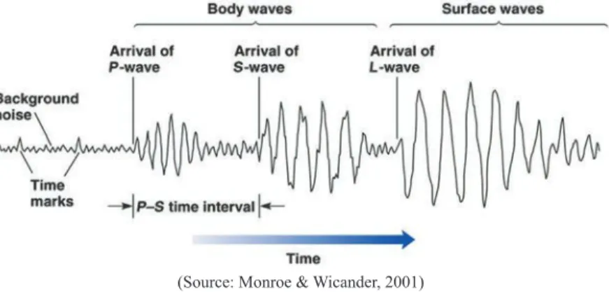
Figure 10 An example of a seismogram recorded by a seismometer. P-wave arrives first followed by S-wave and surface waves
On a seismogram from an earthquake, the P-wave is the first signal to arrive, followed by the slower S-wave, then the surface waves (Figure 10). The arrival times of the P-wave and S-wave at different seismographs are used to determine the
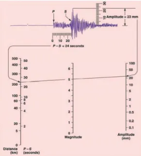
location of the earthquake. Given that we know the relative speed of P-wave and S-wave, the time difference between the arrivals of the P-wave and S-wave determines the distance the earthquake is from the seismograph (Figure 11). To determine the location of an earthquake, the distance of the earthquake must be determined from at least three seismic recording stations. Circles with the appropriate radius are then drawn around each station. The intersection of three circles uniquely identifies the earthquake epicentre (Figure 12).
The amplitude of the largest seismic wave is used to determine the strength of the earthquake (Figure 13).
(Source: Monroe & Wicander, 2001)
Figure 11 Time-distance graph showing the average travel times for P-wave and S-wave. The farther away a seismograph is from the focus of an earthquake, the longer the interval between the arrivals of the P-wave and S-wave
(Image: Copyright of Columbia University)
Figure 12 Epicentre of an earthquake is determined by a triangulation technique from at least three seismic stations (A located 1500 km, B located 5,600 km and C located 8,500 km from the earthquake source)
(Source: Monroe & Wicander, 2001)
Figure 13 Magnitude of an earthquake determined by the amplitude of the seismic wave. The amplitude of the largest wave produced by an event is corrected for distance and assigned a value on an open-ended logarithmic scale
What Determines the Size or Magnitude of an Earthquake?
The size or magnitude of an earthquake, usually expressed as its seismic moment (quantity used by seismologists), is defined by the amount of energy that is released (Figure 14). This is determined by the area of the fault that ruptured during the earthquake, the amount of slip on the fault, and the physical properties of the rocks involved.
Seismic moment is then converted into a Moment Magnitude Scale (MMS), commonly abbreviated as Mw or just M, which provides a simple and convenient numerical scale with which to compare earthquakes. The Mw scale was developed in the 1970s to succeed in the 1930s-era Richter Magnitude Scale or Local Magnitude Scale (ML). The Richter Magnitude Scale is effective for nearby earthquakes below magnitude 4, but not for larger earthquakes. Two other types of magnitude are used depending on the size and depth of the earthquake. For large earthquake occurring near the surface, the Surface Magnitude (Ms) is used. For small-medium earthquake occurring deep within the earth, the Body Magnitude (Mb) is used.
With the use of certain formula, the three different magnitude types can be converted to Mw.
(Image: Copyright of USGS)
Figure 14 The left side of the chart shows the magnitude of the earthquake and the right side represent the amount of high explosive required to produce the energy
Magnitudes are based on a logarithmic scale (base 10).
What this means is that for each whole number that goes up on the magnitude scale, the amplitude of the ground motion recorded by a seismograph goes up ten times. Using this scale, a magnitude 5 earthquake would result in ten times the level of ground shaking as a magnitude 4 earthquake (and 32 times as much energy would be released) (Stein & Wysession, 2003).
What is the Difference between Magnitude and
Intensity?
Moment magnitude measures the energy released by an earthquake and is expressed as an Arabic number (e.g. Mw 8.2). Intensity is a measure of how that energy release is experienced at the surface, and how it affects people and infrastructure at a given location (Table 1). It is ranked on a qualitative scale, based for example on observations of damage to different types of buildings, and is sometimes expressed as a Roman numeral (e.g. intensity IX), commonly known as Mercalli Scale. Importantly, the magnitude of a particular earthquake is the same, irrespective of location, whereas the intensity of the earthquake varies from place to place.
This means that a location can experience the same intensity from a large-magnitude earthquake that is far away or a smaller earthquake that is nearby.
The Mercalli scale is not considered as scientific as the Richter scale, though. Some witnesses of the earthquake might exaggerate just how bad things were during the earthquake and may not find two witnesses who agree on what happened; everybody will say something different. The amount of damage caused by the earthquake may not accurately record how strong it was either.
Some things that affect the amount of damage that occurs are: (a) the building designs, (b) the distance from the epicentre, and (c) the type of surface material (rock or dirt) the buildings rest on.
Different building designs hold up differently in an earthquake and the further you are from the earthquake, the less damage you will usually see. Whether a building is built on solid rock or sand makes a big difference in how much damage it takes. A solid rock usually shakes less than sand, so a building built on top of the solid rock should not be as damaged as it might if it was sitting on a sandy lot.
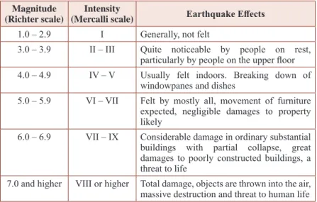
Table 1 Relationship between magnitude and intensity of the earthquake Magnitude
(Richter scale)
Intensity
(Mercalli scale) Earthquake Effects
1.0 – 2.9 I Generally, not felt
3.0 – 3.9 II – III Quite noticeable by people on rest, particularly by people on the upper floor 4.0 – 4.9 IV – V Usually felt indoors. Breaking down of
windowpanes and dishes
5.0 – 5.9 VI – VII Felt by mostly all, movement of furniture expected, negligible damages to property likely
6.0 – 6.9 VII – IX Considerable damage in ordinary substantial buildings with partial collapse, great damages to poorly constructed buildings, a threat to life
7.0 and higher VIII or higher Total damage, objects are thrown into the air, massive destruction and threat to human life
How does Local Geology Affect Shaking?
Shaking during an earthquake is caused by the passage of seismic waves through the Earth. These waves are produced by slip on the fault and travel away from the fault in all directions. The shaking at any particular point depends on the size of the waves, and thus in part on the conditions along the pathway that the waves take to that point (Figure 15). Different types of rock and the interactions between the waves and topography can cause the waves to either be amplified (leading to locally greater shaking and intensity)
or attenuated (leading to decreased shaking and intensity). For example, buildings built in basins filled with soft sediment (e.g. Kota Kinabalu International Airport), often experience greater intensities than nearby buildings on bedrock (e.g. Universiti Malaysia Sabah), both because the seismic waves are amplified by the sediment and the waves are reflected off the bedrock at the edges of the basin.
(Source: Monroe & Wicander, 2001)
Figure 15 Amplification of seismic waves on different surface material condition.
Poorly consolidated and water-saturated sediment tend to amplify the waves several times
How are the Likely Size and Frequency of Future
Earthquakes Estimated?
The size and frequency of future earthquakes can be estimated by either examining the size and frequency of past earthquakes from historical and instrumental records and from pre-historical geological evidence (paleoseismology) or by using measuring techniques – such as GPS or satellite radar interferometry – to estimate the rates at which plates are moving and thus infer how and where stress is accumulating. Both approaches provide some insights into the
potential size of future earthquakes and how often they may be expected to occur on average. It is not currently possible, however, to predict where and when a particular earthquake will happen, or how large it will be. Instead, scientists may be able to use these techniques to identify specific areas where stress is likely to be accumulating and therefore where the likelihood of an earthquake may be higher.
What is Seismic Hazard and How is it Measured?
Seismic hazard is a measure of the potentially damaging effects of some future earthquake at a specific location. These effects are often, but not exclusively, due to the shaking caused by the earthquake. Besides ground shaking, other processes, such as landslides and liquefaction, can form important ‘secondary hazards’ triggered by the earthquake. Shaking can be expressed qualitatively in terms of intensity, or quantitatively in terms of peak ground acceleration (PGA).
Table 2 Relationship between intensity and PGA values
Intensity PGA (%g) Perceived shaking Potential damage
I < 0.05 Not felt None
II – III 0.3 Weak None
IV 2.8 Light None
V 6.2 Moderate Very light
VI 12 Strong Light
VII 22 Very strong Moderate
VIII 40 Severe Moderate/ heavy
IX 75 Violent Heavy
X+ > 139 Extreme Very heavy
Note: Scale based upon Worden et al., 2012
PGA is the maximum acceleration that the ground surface experiences during an earthquake and is usually given as a fraction of the Earth’s gravitational acceleration (g). Generally speaking, a PGA of about 0.001 g (0.01 m/s) is perceptible by people, a PGA of around 0.2 g (0.02 m/s) causes most people to lose their balance, and a PGA of around 0.7 g (7 m/s) will cause the collapse of all but the best-designed buildings. Table 2 shows a rough relationship between PGA and intensity values.
What is Involved in a Seismic Hazard Assessment?
An assessment of seismic hazard involves understanding the sources that generate earthquakes in a region (i.e. the location, size and type of fault), and the characteristics of those earthquakes (e.g.
frequency of occurrence and maximum magnitude). Data from past earthquakes are then used to predict how those sources produce shaking at a particular location. Seismic hazard assessment often takes one of two forms:
• Deterministic seismic hazard assessment (DSHA) consists of estimating the level of ground shaking associated with a particular earthquake – for example, the PGA associated with a 6 Mw earthquake on a particular section of the Mount Kinabalu Normal fault. This approach is scenario- specific, which can help decision-makers visualise the potential impacts of an earthquake. A problem with this approach, however, is that there are many candidate faults that could affect a given location, so it is difficult to design a comprehensive set of scenarios.
• Probabilistic seismic hazard assessment (PSHA) consists of estimating the probability that a certain level of ground shaking will be exceeded within a given time period at the location of interest. Unlike DSHA, PSHA takes into account
multiple scenarios associated with earthquakes on multiple faults, and so must express the hazard in probabilistic terms.
For example, a given location might have a 10% probability that PGA will exceed 0.1 g within 50 years, or in other words, the return period for shaking greater than 0.1 g is 500 years (usually referred to as 475 years). PSHA can be conducted for a single location or a larger area, depending on its intended use (e.g. to inform building codes).
What is Probabilistic Seismic Risk?
To understand the full effects of an earthquake, seismic hazard assessment must be combined with some understanding of how the earthquake will impact upon people and infrastructure to create risk. Probabilistic seismic risk is the probability of some adverse consequence (e.g. damage to buildings, human casualties or monetary losses) occurring due to the hazard. Accurate assessments of risk depend on reliable estimates of seismic hazard, exposure and vulnerability.
STATUS OF
EARTHQUAKE SCIENCE IN MALAYSIA
I
n this section, the state of scientific understanding of earthquakes in Malaysia in terms of how and why earthquake happens, the consequences of an earthquake on the natural environment and the people who live in it and their mitigation is reviewed.Plate Tectonic Movements Around Malaysia
Legend: MT: Manila Trench, NT: Negros Trench, ST: Sulu Trench, CT: Cotabato Trench, NST: North Sulawesi Trench, NWST: NW Sabah Trough, PHF: Philippine Fault, PKF: Palu-Koro Fault, MF: Matano Fault, SF: Sorong Fault, IRF: Irian Fault, AF: Andaman Fault, GSF: Great Sumatran Fault, JF: Java Fault
Figure 16 Tectonic setting of Malaysia showing major plate boundaries (thick yellow line) and movements. Malaysia lies away from the active plate boundaries along the Sunda Trench and Philippine Trench. The Indian-Australian Plate moving northwards (7 cm/yr). The Philippine-Caroline-Pacific Plate moving relatively faster towards the west (10 cm/yr)
Malaysia which lies on the stable Sunda Plate and semi-stable stretched South China Sea is only mildly susceptible to earthquake (Figure 16). Peninsular Malaysia sitting on the Sunda Shelf lies passively behind the active Great Sumatran Fault (GSF) Zone and Sunda Trench Subduction Zone. Global Positioning System (GPS) measurements indicate rates of movements of between 2 – 5 cm/yr along the Great Sumatra Fault Zone (Natawidjaja & Triyoso, 2007).
Sabah and Sarawak sitting on the semi-stable South China Sea are to a certain extent influenced by the active mobile belts in Sulawesi and Philippines. The active Sulu Trench subduction zone continues
into East Sabah (Tongkul, 1991). Similarly, the movement along the Palu-Koro Fault (PKF) in Sulawesi appears to affect Southeast Sabah (Rangin et al., 1990). GPS measurement of movement across the Palu-Koro Fault showed 3.4 cm/yr left-lateral strike-slip movement (Walpersdorf, Vigny, Subarya, & Manurung, 1998). In the South China Sea, the NW Sabah Trough (NWST) which was probably once associated with subduction zone is not seismically active. Active thrust faults found along the trough may mostly be associated with sedimentary loading and slumping or crustal shortening (Sapin, Hermawan, Pubellier, Vigny, & Ringenbach, 2013; Hall, 2013; King, Backé, Morley, Hillis, & Tingay, 2010;
Hesse, Back, & Franke, 2009).
Earthquake Hazards in Malaysia
Figure 17 Distribution of regional earthquake (magnitude more than 5 Mw) surrounding Malaysia associated with the interaction of the three major plates, Sunda, Philippines Sea and Indian-Australian. The colour of the dots corresponds to the depth of the earthquake: Purple (0 – 33 km), Blue (33 – 70 km), Green (70 – 150 km), Yellow (150 – 300 km), Orange (300 – 500 km) and Red (500 – 800 km).
Earthquakes generated from USGS Database (1900 – 2018)
Malaysia is affected by both regional and local earthquakes.
Significant earthquakes from West Sumatra have been felt several times in Peninsular Malaysia (Figure 17). The USGS earthquake data shows about 50 earthquakes with magnitude scale more than 6 (Mw) lies within 1,000 km from Kuala Lumpur since 1973.
Although the effect is small, it is still of concern, especially to vulnerable high-rise buildings. Similarly, earthquakes from the Sulu and Celebes seas are periodically felt as slight tremors in Sabah.
The USGS earthquake database shows a total of 221 earthquakes with magnitude scale more than 6 (Mw) within 1,000 km from Kota Kinabalu since 1973. Rare earthquake from Kalimantan is felt as slight tremors in Sarawak.
Earthquakes in Peninsular Malaysia
Earthquakes felt in Peninsular Malaysia since the early 1800s are mostly related to earthquakes from Sumatra and Andaman Islands (Leyu et al., 1985, Table 3). In all these tremors, no casualties or damages to houses were recorded. The most severe cases reported objects falling from shelves. Since 1970, earthquake records available from Incorporated Research Institutions for Seismology (IRIS) Earthquake Database shows local earthquakes in Peninsular Malaysia. Since 2007, the Malaysian Meteorological Department (MetMalaysia) recorded several small local earthquakes in Peninsular Malaysia (Figure 18, Appendix 1). These earthquakes, mostly less than 4 Mw in magnitude are located in Bukit Tinggi, in Pahang, Kuala Pilah in Negeri Sembilan and Tasik Temenggor in Perak, and occurred after 2006 (Figure 19). Except for creating some minor tremors and shaking of high-rise buildings, these earthquakes have not resulted in any significant damage.
Table 3 Historical earthquakes felt in Peninsular Malaysia
No. Event date Areas affected Origin
1 06-12-1815 Penang – minor tremor Uncertain
2 24-11-1833 Penang, Malacca – minor tremor Indonesia 3 06-01-1843 Penang, Singapore – slight tremor Uncertain
4 22-06-1846 Penang – minor tremor Uncertain
5 16-02-1861 Singapore, Malacca, Penang – Minor tremor Indonesia
6 23-02-1861 Malacca – slight tremor Uncertain
7 26-04-1861 Penang – minor tremor Uncertain
8 19-08-1973 Penang – minor tremor Uncertain
9 26-08-1883 Whole Peninsular – ground shaking, heard a loud explosion
Krakatoa explosion, Indonesia 10 17-05-1892 Singapore, Johor, Malacca, Penang – strong tremors,
buildings shook, loose objects removed from shelves Sumatra 11 03-06-1909 Malacca, Singapore – violent shaking, clocked stopped
in Singapore, whole house shaking Upper Padang, Sumatra
12 25-06-1914 Singapore – minor tremor Bencoolen,
Sumatra
13 29-02-1916 Kapar – minor tremor Uncertain
14 27-07-1916 Kapar, Klang – minor tremor Sumatra
15 31-01-1922 West Peninsular – minor tremor Uncertain
16 07-02-1922 West Peninsular – minor tremor Uncertain
17 28-06-1926 Singapore – minor tremor Sumatra
18 20-01-1931 Selangor – minor tremor Sumatra
19 03-08-1935 Penang – minor tremor Sumatra
20 28-12-1935 Singapore – minor tremor Sumatra
21 19-09-1936 Selangor, Penang – minor tremor Sumatra
22 24-05-1942 Kuala Lumpur – slight tremor lasted 15 seconds,
buildings shake slightly Sumatra
23 13-01-1948 Singapore – minor tremor Sumatra
24 24-08-1948 Teluk Anson – minor tremor Uncertain
25 10-03-1949 Singapore – minor tremor Uncertain
26 15-03-1952 Singapore – minor tremor Sumatra
27 31-12-1962 Singapore, Kuala Lumpur – slight tremor Sumatra 28 12-04-1967 West Peninsular – high buildings in Penang, Kuala
Lumpur, Alor Star and Ipoh swayed alarmingly North Sumatra 29 21-08-1967 Penang, Ipoh, Kuala Lumpur – minor tremor Sumatra 30 04-02-1971 Singapore, Kuala Lumpur – minor tremor, affected tall
buildings Uncertain
31 20-06-1976 Penang, Kulim – minor tremor, shook some high-rise
buildings Sumatra
32 08-03-1977 Kuala Lumpur, Malacca, Muar – minor tremor Sumatra
33 16-03-1979 Penang – minor tremor Sumatra
34 01-04-1980 Penang – minor tremor Sumatra
35 24-02-1982 Penang – minor tremor Sumatra
36 04-04-1983 Penang, Petaling Jaya, Kedah – minor tremor Sumatra
Figure 18 Earthquake distribution in Peninsular Malaysia based on MetMalaysia and IRIS Earthquake Databases (1970 – 2018). The earthquakes are concentrated in Bukit Tinggi, Kuala Pilah, Manjung, Temenggor and Kenyir
Figure 19 Time series earthquake distribution in Peninsular Malaysia based on MetMalaysia and IRIS Earthquake Databases (1970 – 2018). Most of the earthquakes occurred after 2006, following the large 2004 earthquake in Sumatra
Earthquakes in Sarawak
Earthquakes felt in Sarawak are mostly related to local earthquakes.
Leyu et al. (1985) documented several historical minor earthquakes around Kuching, Samarahan, Bintulu, Bekenu and Niah areas (Table 4). These earthquakes caused minor damage to buildings. During the period from 1970 to May 2019, about 20 light to moderate (magnitude larger than 3 Mw) earthquakes were recorded onshore Sarawak (Figure 20, Appendix 2). Most of the earthquakes have a magnitude less than 5 Mw except for two which were recorded at Batu Niah and Bukit Mersing. Most of the earthquakes were recorded after 2006 (Figure 21).
Table 4 Historical earthquakes felt in Sarawak
No. Event date Areas affected Origin
1 26-06-1874 Simunjan – mild tremor Uncertain
2 24-06-1876 Kuching – slight tremor Uncertain
3 26-08-1883 Kuching – minor tremor Krakatoa eruption, Indonesia 4 07-03-1910 Simanggang, Sadong, Kuching – minor
tremor
Uncertain
5 07-04-1910 Samarahan to Serian – minor tremor Uncertain 6 19-11-1953 Kuching – airport shaken, bungalows
rocked
Uncertain
7 16-07-1965 Bintulu, Miri, Lutong – light tremor Central Sarawak 8 21-07-1965 Bekenu and Niah areas – smashed
windows and slammed doors, very large limestone stalactite broke from below the ceiling in Niah Cave
Central Sarawak
9 04-07-1970 Bekenu area – tremors lasted for 10 seconds, government quarters and wooden houses slightly damaged
Central Sarawak Source: Leyu et al., 1985
Figure 20 Distribution of earthquakes in Sarawak based on MetMalaysia and IRIS Databases. The earthquakes are mostly located around Niah and Selangau
Earthquakes in Sarawak (1970 – April 2019)
Figure 21 Time series earthquakes in Sarawak based on MetMalaysia and IRIS Databases. The higher number of earthquake record after 2006 is due to better seismic instrumentation coverage in Sarawak.
Earthquakes in Sabah
Earthquakes in Sabah are mostly generated locally and regionally from the Philippines (Sulu and Celebes Seas) and Indonesia (Kalimantan). Wilford (1967) records several historical earthquakes that were felt in Sabah that are not well documented in the USGS Earthquake Database. Some of the significant earthquakes reported in the British North Borneo Herald newspaper are shown in Table 6. These historical earthquakes occurred mostly in Tawau, Lahad Datu, Sandakan, Kudat and Keningau.
Table 5 Historical earthquakes felt in Sabah
No. Event date Areas affected Origin
1 21-09-1897 Sandakan – house cracked, clock tower stopped Philippines
2 05-04-1902 Tawau – severe tremor Kalimantan
3 01-10-1902 Sandakan – caused fissure on the ground Philippines
4 02-05-1903 Tawau – minor tremor Uncertain
5 31-12-1908 Kalabakan, Tawau – S.S. Victoria heeled over Kalimantan
6 15-05-1909 Tawau – damaged to crockery Uncertain
7 27-07-1911 Ranau – weak tremor Ranau
8 06-06-1912 Timbang Batu, Marudu Bay – house shook violently
Kudat 9 19-04-1923 Tawau-Cowie Harbour – tremor lasting for 20
seconds
Tarakan 10 11-08-1923 Lahad Datu – tremor lasting 30 seconds, buildings
shook and swayed, window rattled Sulawesi Sea 11 25-01-1928 Bengkoka area – severe tremor Pitas 12 27-03-1932 Pingan-Pingan area – strong tremor Pitas
13 17-10-1932 Keningau – minor tremors Keningau
14 04-12-1932 Sandakan – slight tremor Celebes Sea
15 02-06-1951 Kudat – several strong tremors, crevasse appear in the street of Kudat, cracks appeared on road, sea wall collapsed, water pipes burst
Kudat
16 30-10-1958 Keningau to Sapong – severe tremor, things falling Tenom 17 28-06-1964 Kennedy Bay – violent tremor Lahad Datu 18 24-01-1965 Kennedy Bay – minor tremor Lahad Datu 19 15-02-1965 Bakapit area – minor tremor Lahad Datu 20 03-03-1965 Bakapit area – minor tremor Lahad Datu
21 18-10-1965 Ranau – weak tremor Ranau
22 19-05-1966 Ranau – strong tremor with slight intensity, rattling of windows and doors and cookery, houses shook violently, felt in Kota Kinabalu, Papar, Penampang, Tuaran, Kota Belud and Tambunan
Ranau
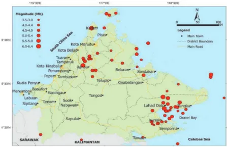
Based on USGS Earthquake Database, during the period from 1900 to May 2019, about 67 light to moderate (magnitude larger than 3.5 Mw) earthquakes were recorded onshore and offshore Sabah (Figure 22, Appendix 3). Most of the earthquakes in Sabah have a magnitude less than 5, apart from the four earthquakes with magnitude 6 and above, such as the 2015 Ranau earthquake, 1976 Lahad Datu earthquake, 1951 Kudat earthquake and 1923 Lahad Datu Earthquake. The epicentres of the earthquakes are concentrated on the east coast of Sabah, around Lahad Datu-Kunak area, and around Kundasang-Ranau area.
Figure 22 Earthquake distribution in Sabah (1900 – 2018) extracted from the USGS database
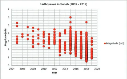
The relatively small number of earthquakes shown by the USGS database is due partly to the detection limit of older seismographs in Sabah. However, since the establishment of new seismographs in 2019 in Sabah more microearthquakes has been recorded in Sabah (Figure 23). For example, during 2015 alone, MetMalaysia recorded 155 small earthquakes (magnitude larger than 2 Mw) in Sabah. The historical earthquake record is still patchy but has improved after 1970 (Figure 24). Since 2005, the earthquake record in Sabah is almost complete (Figure 25). For the last 100
years, there has been a regular occurrence of an earthquake with a magnitude greater than 5 Mw (Figure 26).
Figure 23 Earthquake distribution in Sabah (1966 – 2019) based on the database of MetMalaysia (2019). There is a heavy concentration of very small earthquakes in Ranau and Darvel Bay areas
Figure 24 Time series of the earthquake in Sabah (1900 – 2019) based on MetMalaysia (2019) and USGS databases showing the incomplete record of Sabah earthquake. Data of magnitude 3.5 – 5.0 missing from 1940 – 1957 and data of
Earthquakes in Sabah (2005 – 2019)
Figure 25 Time series of earthquakes in Sabah after 2005 based on Malaysia Meteorological Department (2019) database. Since 2015 a complete range of magnitudes have been recorded
Time series of earthquakes = 5 or greater (1920 – 2019)
Figure 26 Time series of earthquakes with a magnitude more than 5 (1920 – 2019) based on Malaysia Meteorological Department (2019) and USGS database. There is a regular occurrence of the earthquake (Mag 5 – 6) for the last 100 years in Sabah.
Potential Source of Regional Earthquakes
The source of regional earthquake for Peninsular Malaysia comes from the active Great Sumatra Fault Zones and Sunda Trench Subduction Zone (or Sunda megathrust) which extends across the Andaman Sea (Figure 27). The Sunda megathrust is the plane of contact between the Indian Ocean Plate descending beneath the Sunda Plate (Sundaland) at a rate of about 7 cm/yr. Rupture of a 1,600-km length of the megathrust caused the great magnitude 9.2 (Mw) earthquake of 26 December 2004. Tens of metres of sudden slip relieved centuries of slowly accumulating strain across the plate boundary. Another rupture of 350-km length at the southern end of the 2004 rupture occurred 3 months later on 23 March 2005, causing another great earthquake (Sieh, 2007). There are also historical accounts of great earthquakes along the rupture, but the accounts are too sparse to tell us much about the details of these large ancient earthquakes. Fortunately, however, corals have been used to characterize in detail some of these events that occurred in 1797 and 1833 (Natawidjaja et al., 2006). Modern GPS geodesy to measure the current accumulation of strains that are building toward the next big megathrust failures have also been used by Sieh (2007). Based on the current rates of strain accumulation, Sieh believes there is a high likelihood that the region will generate a great earthquake within the next few decades.
The Great Sumatra Fault (GSF) which occur along the length of Sumatra is a right-lateral strike-slip fault, absorbing the oblique subduction of the Indian Ocean Plate towards the north under the Sunda Plate. Numerous earthquakes measuring up to magnitude 7 (Mw) and depth of less than 100 km occur along the Great Sumatra Fault. The small earthquake in Peninsular Malaysia may also be related to the shear stress generated by the oblique subduction. GPS data in Peninsular Malaysia indicate intra-plate crustal deformation (Abdul Rahim Samsudin et al., 2014).
Figure 27 The interaction between the Indian Ocean Plate and Sunda Plate along the Sunda Subduction Zone. The subducting Indian Ocean slab under Sumatra generates numerous large earthquakes up to Magnitude 9 (Mw) in Sumatra and minor earthquakes in Peninsular Malaysia. Earthquakes generated from USGS Database (1900 – 2018). The colour of the dots corresponds to the depth of the earthquake: purple (0 – 33 km), blue (33 – 70 km), green (70 – 150 km), yellow (150 – 300 km)
The source of regional earthquakes for Sabah comes from the active subduction zones marked by the Philippine Trench, Manila Trench (MT), Negros Trench (NT), Sulu Trench (ST), Cotabato Trench (CT) and North Sulawesi Trench (NST) (see Figure 16).
The Philippine Subduction Zone is the plane of contact between the Philippine Sea Plate descending beneath the extended Sunda Plate at a rate of about 10 cm/yr. The Philippine Sea Plate descends up to 600
km deep under the Celebes Sea and Sulu Sea areas (Figure 28). The stress generated by the westward subducting slab of the Philippine Sea Plate is being absorbed by shallow faults in the Philippines, Sangihe Islands and Sabah. GPS measurement in Sabah indicates intra-plate crustal deformation which may be related to the Sunda- Philippine sea plate convergence (Mohamad, Simons, Kamaludin Omar, & Ambrosius, 2014; Mohamad et al., 2017).
Figure 28 The subducting Philippine Sea slab under the Celebes Sea generates numerous large earthquakes in the Philippines and moderate earthquakes in Sabah and Sarawak. Earthquakes generated from USGS Database (1900 – 2018). The colour of the dots corresponds to the depth of the earthquake: purple (0 – 33 km), blue (33 – 70 km), green (70 – 150 km), yellow (150 – 300 km), orange (300 – 500 km), red (500 – 800 km)
Potential Source of Local Earthquakes
Local earthquakes are caused by active faults in Malaysia. There are several potential active faults mapped in Peninsular Malaysia, Sarawak and Sabah (Ismail et al., 2015). These potential active faults may have utilised existing ancient faults, which are quite numerous in Malaysia.
Active Faults in Peninsular Malaysia
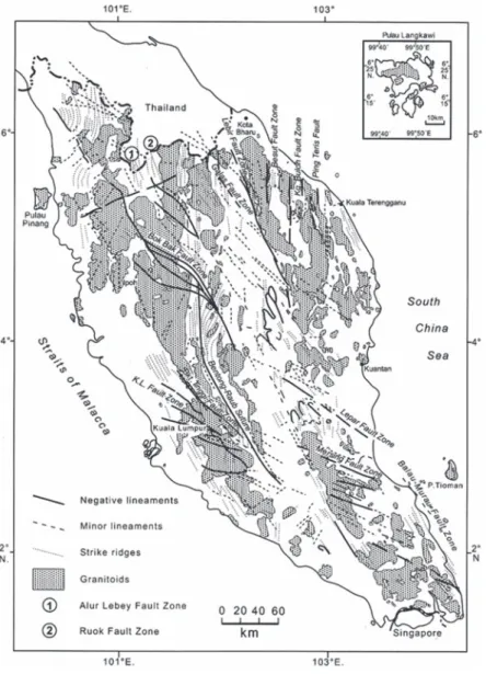
In Peninsular Malaysia, the potential active faults appear to be related to major ancient faults. Hutchison and Tan (2009) provided a summary of the major ancient’s faults trending N-S, NW-SE, NNE- SSW, and E-W in Malaysia. Some of the well-known faults include the Bak-bak Fault, Lepar Fault, KL Fault, Bukit Tinggi Fault, Mersing fault, Galas Fault, Besut Fault, Kg. Buloh Fault, Ping Teris Fault and Balau-Murau Fault (Figure 29).
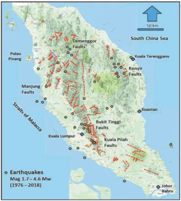
The occurrence of small earthquakes in the Bukit Tinggi, Kuala Pilah, Manjong, Temenggor and Kenyir areas indicates the presence of potentially active faults in these areas. A recent study by Ismail et al. (2015) identified several potential active fault zones in these areas (Figure 30). The occurrence of induced light earthquakes with a maximum magnitude of 4.6 during the flooding of the Kenyir Dam in Terengganu in 1984 – 1987 may be associated with the reactivation of old N-S and NW-SE strike-slip faults in the region.
In Bukit Tinggi, the earthquakes appear to be associated with the NW-SE Bukit Tinggi Fault Zone (Figure 31).
Source: Hutchison & Tan, 2009
Figure 29 Location of major ancient faults in Peninsular Malaysia trending NW-SE, N-S and NNE-SSW
Figure 30 Potential active faults (red lines) in Peninsular Malaysia. The potential active faults trending NW-SE, N-S and NNE-SSW are possibly reactivated ancient faults (modified from Ismail et al., 2015)
Figure 31 Potential Bukit Tinggi active faults trending NW-SE, N-S and NE-SW and cluster of small earthquakes (magnitude less than 3.5) (modified from Ismail et al., 2015). The reactivation of the NW-SE trending Bukit Tinggi Fault Zone may have produced the earthquakes
Active Faults in Sarawak
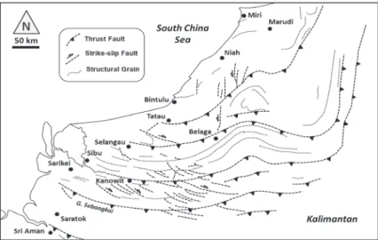
In Sarawak, the potential active faults are also associated with ancient faults (Figure 32). Several major ancient thrust faults oriented approximately E-W occur in Sri Aman, Gunung Sebangkoi, Kanowit, Selangau and Tatau oriented parallel to the structural grain.
These thrust faults change in orientation from E-W to N-S towards North Sarawak. The thrust faults are dissected by a series of NW- SE and N-S strike-slip faults, showing left-lateral and right-lateral movements, respectively (Tongkul, 1997).
Figure 32 Locations of ancient faults in Sarawak trending NW-SE and N-S are possibly reactivated ancient faults (modified from Tongkul, 1997)
Potential active faults located near Niah and Selangau has generated earthquakes up to magnitude 5.4 (Mw) (Figure 33). The potential active left-lateral strike-slip faults in Niah appears to be associated with the Tubau Fault Zone (Figure 34). The potential active right-lateral strike-slip faults in Selangau appears to be associated with the Mersing Fault Zone (Figure 35). The potential active faults near Sri Aman appears to be associated with the Sungai Lupar Fault Zone. The reactivation of ancient faults in Sarawak may be due to stress generated by the subduction of the Philippine Sea Plate under the Sunda Plate.
Figure 33 Potential active faults in Sarawak associated with minor earthquake activities. The potential active faults trending NW-SE and N-S are possibly reactivated ancient faults
Figure 34 Potential active N-S strike-slip faults (yellow line) near Niah National Park. Three earthquakes occurred in this area (purple circle). The focal mechanism (beach ball) indicates N-S left-lateral strike-slip fault
Figure 35 Potential active NW-SE strike-slip faults (yellow line) near Selangau- Nanga Merit. Two earthquakes occurred in this area (purple circle). The focal mechanism (beach ball) indicates right-lateral NW-SE strike-slip fault
Active Faults in Sabah
In Sabah, the potential active faults are also associated with ancient faults (Figure 36). The ancient faults comprised of thrust faults, strike-slip faults and normal faults associated with past tectonic compression in Sabah. The thrust faults follow the structural grain and occur all over Sabah. The strike-slip faults occur mostly in Ranau and Telupid whereas the normal faults occur in Tambunan and Keningau valleys.
Potential active faults are mostly concentrated in Ranau, Kudat, Sandakan, Lahad Datu and Kunak areas. Earthquake focal mechanism solutions provided by USGS shows both compressional stress regime (thrust faults and strike-slip faults) and extensional stress regime (normal faults) in Sabah (Figure 37). The compressional stress regime is mostly recorded in Southeast Sabah, whereas the extensional regime is mostly recorded in West and North Sabah. The compressional and extensional stress directions are mostly oriented WNW-ESE. These potential active faults are associated with the crustal shortening of Sabah due to the westward movement of the
Source: Tongkul, 2017
Figure 36 Locations of ancient faults in Sabah trending NW-SE, N-S and NE-SW
Figure 37 Locations of potential active faults in Sabah. The potential active faults trending NE-SW in West Sabah are mostly normal faults whereas the faults trending NW-SE and NE-SW in East Sabah are strike-slip faults and thrust faults (based on Tongkul, 2017). The corresponding focal mechanism (beach ball) indicates both extension and compression regime in Sabah
Figure 38 Active strike-slip faults oriented N65E caused a split in the trunk of two coconut trees (A and B). The strike-slip fault is associated with a normal fault (C) and a semi-active mud volcano located near Lahad Datu Airport
Figure 39 Active mud volcanoes associated with active fault movements at Binuang Oil Palm Plantation, Kunak
Figure 40 Several active mud volcanoes aligned NE-SW and NW-SE associated with active fault movements near Tabin, Lahad Datu. The Lipad Mud Volcano near Tabin shows recent uplift
Minor ground movements due to active faults are clearly observed in Lahad Datu and Kundasang areas (Tongkul, 2017; Ismail et al., 2015; Tongkul & Omang, 2010; Tjia, 2007). In Lahad Datu area, the manifestation of the active faults can be seen from ground movement causing a split in coconut tree trunks and presence of a mud volcano near Lahad Datu Airport (Figure 38). The presence of mud volcanoes in Kunak (Figure 39) and Tabin (Figure 40)