CTJ`
ý Y
ONrnn P5'
1 " "
PLANNING ANALYSIS FOR INLAND NAVIGATION DEVELOPMENT IN THE BARAM RIVER USING LOGICAL
FRAMEWORK APPROACH
Muhammad Sadli Bin Abdllah
lt
753 Bachelor of Engineering with Honours
N D52 (Civil Engineering)
2006
2006
Universiti Malaysia Sarawak
fk BORANG PENYERAHAN LAPORAN PROJEK TAHUN AKHIR
Judul: PLANNING ANALYSIS FOR INLAND NAVIGATION DEVELOPMENT IN THE BARAM RIVER USING LOGICAL FRAMEWORK APPROACH
SESI PENGAJIAN: 2002-2006
Saya MUHAMMAD SADLI BIN ABDLLAH (HURUF BESAR)
mengaku membenarkan tesis ini disimpan di Pusat Khidmat Iviaklumat Akademik, Universiti Malaysia Sarawak dengan syarat-syarat kegunaan seperti berikut:
1. Hakmilik kertas projek adalah di bawah nama penulis melainkan penulisan sebagai projek bersama dan dibiayai oleh UNIMAS, hakmiliknya adalah kepunyaan UNIMAS.
2. Naskhah salinan di dalam bentuk kertas atau mikro hanya boleh dibuat dengan kebenaran bertulis daripada penulis.
3. Pusat Khidmat Maklumat Akademik, UNIMAS dibenarkan membuat salinan untuk pengajian mereka.
4. Kertas projek hanya boleh diterbitkan dengan kebenaran penulis. Bayaran royalti adalah mengikut kadar yang dipersetujui kelak.
5. * Saya membenarkan/tidak membenarkan Perpustakaan membuat salinan kertas projek ini sebagai bahan pertukaran di antara institusi pengajian tinggi.
6. ** Sila tandakan ( X ) di mana kotak yang berkenaan Q
FTý
SULZT (Mengandungi maklumat yang berdarjah keselamatan atau kepentingan Malaysia seperti yang termaktub di dalam AKTA RAHSIA RASMI 1972).
TERHAD (Mengandungi maldumat TERHAD yang telah ditentukan oleh organisasi/
badan di mana penyelidikan dijalankan).
TmAK TERHAD
(TANDATANGAN PENULIS)
Alamat tetap: 8 KOMPLEK JPS,
JALAN PARIT MESJID 82000 PONTIAN JOHOR DARUL TAKZIIvI
Tarikh:
CATATAN
/ 1-10 S/'o6 "
A
#A
Disahkan oleh
#a-k4o-
ANYATANGAN PENYELIA)
Associate Professor Dr. F. J Putuhena ( Nama Peny+elia )
Tarikh:
1' or Df
Potong yang tidak berkenaan.
Jika Kertas Projek ini SULIT atau TERHAD, ills lampirkan surat daripada pihak berkuasal organisaai berkeuaan dengan menyertakan sekaU tenspoh kertas projek. Ini perlu dikelaskan sebagai SULIT atau TERHAD.
APPROVAL SHEET
This project report attached here to, entitled "PLANNING ANALYSIS FOR INLAND NAVIGATION DEVELOPMENT IN THE BARAM RIVER USING LOGICAL FRAMEWORK APPROACH" prepared and submitted by Muhammad Sadli bin Abdllah in partial fulfillment of the requirements for the degree of Bachelor of Engineering (Civil) is hereby accepted.
/ 710i-lb c
Associate Professor Dr. F. J Putuhena Date Civil Engineering Department
Faculty of Engineering Universiti Malaysia Sarawak
Pusat Khidmat Maklumat Akademic UMVERSITI MALAYSIA SARAWAK
P. KHIDMAT MAKLUMAT AKADEMS(
UNMMAS
11111111 IAII1ARIYIII
1000166085PLANNING ANALYSIS FOR INLAND NAVIGATION DEVELOPMENT IN THE BARAM RIVER USING LOGICAL FRAMEWORK APPROACH
MUHAMMAD SADLI BIN ABDLLAH
This project is submitted in partial fulfillment of
the requirements for the degree of Bachelor of Engineering with Honours (Civil Engineering)
Faculty of Engineering
UNIVERSITI MALAYSIA SARAWAK 2006
Untuk mak dan ambok...
adik-adik yang banyak memberi semangat dan yang tersayang
Terima Kasih atas segalanya
ACKNOWLEDGEMENTS
Thanks to Allah, the most Merciful and Gracious for guiding and giving me strength to complete this Final Year Project within the time given.
I would like to express sincere appreciation to my supervisor, Associate Professor Dr. F. J Putuhena for his kindness, support and guidance me very well to complete my Final Year Project. I feel grateful for the help.
Also thanks a lot for the involvement and contribution of friends, Sarawak Development Institute, Sarawak River Board and other people directly or indirectly.
Last but not least, to my beloved family and my love one who has given me spiritual supports and encouragement in the completing of this Final Year Project.
III
ABSTRACT
Baram River is one of the 21 main rivers in Sarawak State. Its length is 607 km and navigable up to 371 km, plays an important role in navigation and water transportation in the rural area. However, there are still a few problems occur in the Sarawak State Government, especially in navigation development activity in Baram River. For example, even though there are jetty and wharf at the main town along the river but it still can't support passenger, good and ships capacity that increase day by day. The unsafe condition around the jetties and wharf also contribute to the problems. Miri Port Authorities which operation at Baram River since 2001 has a river depth problem where only 3 meter ship can navigable to the port. It caused decrease of ship passage to the Miri Port. There are several governments and private agencies are involved in developing navigation activities, Integrated Inland Navigation would be introduced. Logical Framework Approach is being develop as an exercise to facilitate workshops for supporting the integrated development and management for Baram River especially navigation. LFA has shown the ability in construction and surveillance a complex and costly project clearly and understandably. This is achieve by structuring the main elements of a project in a matrix, which summarize the project, highlighting logical linkages between intended input, planned activities an expected results and records the underlying assumption.
iv
ABSTRAK
Sungai Baram merupakan merupakan salah satu daripada 21 sungai utama di Negeri Sarawak. Sungai sepanjang 607 km dan boleh dimudiki sejauh 371 km ini memainkan peranan yang penting bagi aktiviti pelayaran dan perhubungan air bagi penduduk kawasan pendalaman. Walaubagaimanapun, masih terdapat masalah-masalah yang masih melanda Kerajaan Negeri Sarawak terutamanya berkenaan dengan pembangunan aktiviti pelayaran di Sungai Baram. Sebagai contoh, walaupun mempunyai jeti dan dermaga di bandar utama sepanjang sungai, tetapi ianya tidak mampu untuk menampung kapasiti penumpang dan barangan yang semakin hari semakin bertambah. Keadaan yang tidak selamat di kawasan jeti dan dermaga juga menyumbang kepada masalah yang dihadapi.
Selain daripada itu, Lembaga Pelabuhan Miri yang beroperasi di Kuala Baram sejak 2001 pula, mempunyai masalah kecetekan laluan masuk yang menghadkan laluan kapal yang melebihi 3 meter apungan. Ini mengakibatkan kekurangan kapal yang boleh masuk berlabuh di Pelabuhan Miri. Terdapat beberapa jabatan kerajaan dan agensi-agensi swasta yang terlibat dalam pengurusan membangunkan aktiviti pelayaran. Oleh yang demikian, "Logical Framework Approach" telah dibangunkan dan digunakan dalam bengkel untuk menyokong pembangunan bersepadu aktiviti pelayaran di Sungai Baram. "Logical Framework Approach" telah menunjukkan kebolehannya dalam pembinaan dan memantau sesuatu projek yang kompleks dan kos yang tinggi dan senang difahami. Ini dicapai dengan pengstrukturan elemen utama sesuatu projek di dalam bentuk matrik yang mana dapat memberi diskripsi, mempamerkan hubung kait secara logik di antara input, aktiviti yang dirancang, output dan rekod serta faktor-faktor atau andaian yang perlu bagi sesuatu projek bagi mencapai matlamat yang diharapkan.
V
Pusat Khidmat Makiumat Akademt UNIVERSm MALAYSIA SARAWAK.
LIST OF CONTENTS
CONTENTS
ACKNOWLEDGEMENTS ABSTRACT
ABSTRAK
LIST OF CONTENTS LIST OF TABLES LIST OF FIGURES ABBREVIATIONS
CHAPTER 1 INTRODUCTION
Page
111
iv
V
vi
X
R1
X11
I
1.0 Background 1
1.1 Physical Condition and Development of Baram River 2
1.2 Issues and Problem 3
1.3 Conceptual Framework 5
1.4 Logical Framework Approach 5
1.5 Objectives of this study 7
1.6 Scope of the study 7
V1
CHAPTER 2 LITERATURE REVIEW
2.0 Introduction
2.1 Activities and Development at Baram River 2.1.1 Inland Navigation Development 2.1.2 Urban and Industrial Development 2.1.3 Agriculture Activities
2.1.4 Aquaculture
2.1.5 Tourism Development 2.1.6 Water Supply Development
2.2 Issues and Problem in the Baram River Development 2.2.1 Planning and Regulation
2.2.2 Ports and Shipping
2.2.3 River Ecology and Environment 2.2.4 Private Jetties
2.2.5 Improvement to Riverine Cargo Terminal
2.3 The Detail of Logical Framework Approach
2.3.1 Terminology of LFA
2.3.2 Analysing The Existing Situation 2.3.3 The Project Design Phase
2.3.4 Strength and Weakness of LFA
12
12 12 13 13 14 14 15 15
16 18 18 19 19
20 24 34 35
vii
CHAPTER 3 METHODOLOGY 37
3.0 Introduction 37
3.1 Project Design with LFA 37
3.2 Problem Analysis 38
3.3 Stakeholder Analysis 39
3.4 Objectives Analysis 40
3.5 Alternative Analysis 41
3.6 Identify Main Project Elements 43
3.7 Identify the External Factors 43
3.8 Identifying the Indicators and Means of Verification 45
3.9 Filling Up the Logical Framework Matrix 46
CHAPTER 4 DATA AND ANALYSIS 47
4.0 Project Design with LFA 4.1 Issues and Problem
4.2 Logical Framework Approach (LFA) 4.2.1 Step 1: Problem Analysis 4.2.2 Step 2: Stakeholder Analysis 4.2.3 Step 3: Objectives Analysis 4.2.4 Step 4: Alternative Analysis
4.2.5 Step 5: Identify Main Project Elements 4.2.6 Step 6: Identify the External factors
47 47
49 51 54 56 59 64
Viii
4.2.7 Step 7: Identifying the Indicators and Mean
Verification. 66
4.2.8 Step 8: Filling Up the Logical Framework Matrix 68
CHAPTER 5 DISCUSSION 73
5.0 Introduction 73
5.1 The output of Logical Framework Approach (LFA). 73
5.1.1 Immediate Objective 74
5.1.2 Development Objective 75
5.2 Inland Navigation Development and Logical Framework
Approach. 76
CHAPTER 6 CONCLUSION AND RECOMMENDATION 78
REFERENCES 80
ix
LIST OF TABLES
TABLES Page
1.0 The Logical Framework.
2.0 Strengths and weakness of LFA.
4.0 Issues and Problems.
4.1 List of stakeholder (Stakeholder Analysis 1) 4.2 Category of Stakeholder (Stakeholder Analysis 2) 4.3 Stakeholder Analysis 3
4.4 Alternative Analysis
4.5 Indicators and Mean of Verification
4.6 Logical Framework Matrix for Inland Navigation Development
8 36 48 52 53 54 58 68
At Baram River. 69
X
LIST OF FIGURES
FIGURES Page
1.0 Important River In Sarawak 1.2 Baram Basin Map.
1.3 Baram River Map.
2.0 IF - THEN Relationship
9 10 11 24
2.1 Problem Tree 25
3.0 Two phases and seven steps of the LFA
3.1 Relationship between assumption and objectives 4.0 Problem-Tree
38 44 50
4.1 Objective-Tree 55
4.2 Inland Navigation Facilities at Baram River 72
xi
ABBREVIATIONS
DID - Department of Irrigation and Drainage EIA - Environmental Impact Assessment LFA - Logical Framework Approach MOVs - Means of Verification
MP - Malaysia Plan
PWD - Public Work Department SRB - Sarawak River Board
X11
CHAPTER 1
INTRODUCTION
1.0 Background
Since ancient time, the inland navigation in Malaysia has been the arteries of the nation, giving life to various economic and social activities. From the early days when the rivers were the main means of communication and transports to present times when rivers drive huge turbines, river have been synonymous with development. This has been the case with Malaysia where the rivers and inland navigation have become vital arteries in the pulsating development and progress.
Sarawak with a land area of 124450 sq. km has 55 navigable rivers which the state with a combined length of 3300 km. Rivers has always played a prominent role in Sarawakian life. They remain the chief line for communication for much of the population even today, and a majority of settlements, whether sedentary (sitting) or shifting, are located close to these arteries of Sarawak.
The rivers in Sarawak are a major mode of transportation for passengers, goods and logs. The major rivers such as the Batang Rajang and Batang Baram
1
and their upper tributaries are busy and important highways into the hinterland.
Along the Batang Rajang, sea going ships and barges carrying goods, logs and produce constantly ply the river alongside express ferry boats. The river mouths are the economic hubs of the respective catchments while the state capital has also developed around a river estuary.
The main navigable waterways are as follows:
a) Rajang River system (navigable about 570 km. ) b) Baram River system (navigable over 371 km. ) c) Batang Lupar system (navigable over 140 km) d) Batang Kemena system (navigable over 50 km) e) Limbang River system (navigable over 80 km) (See Figure 1.0)
Approximately 3,000 registered vessels of various types and designs (general cargo coasters, coastal and inland passengers express vessel, motor launchers, tugs and barges and multipurpose and specialized crafts engaged in the petroleum industry) work in coastal and inland waterways. There is also an estimated 4,000 unlicensed crafts (long boats, wooden motor launches and outboard motor craft) used mainly by rural and coastal inhabitants. The rivers are also the principle means for log transportation as well as storage (log ponds).
1.1 Physical Condition and Development of Baram River
Baram River is approximately 607 km long and it navigable up to 371 km. The catchments area of Baram River is about 22,325 sq. km and is located in
2
a tropical rainforest region. The average elevation of the basin is 602 m, with a maximum elevation of 4,833 m. Rainfall in the basin is quite high, averaging 3,225 mm. annually and is spread throughout the year. The river is quite sinuous in a nature, particularly in its lower reaches. Currently Baram River is used for agriculture and aquaculture, industries, recreation and important thing is navigation.
The development that was taken places in the Baram River Basin includes the following: -
i) Navigation
ii) Urban and industrial Development.
iii) Land Development iv) Tourism Development.
v) Aquaculture Development.
vi) Agriculture Development.
vii) Water Supply Development.
(See Figure 1.2)
1.2 Issue and problem
There are some issues and problem regarding the inland navigation development in the Baram River. The issues and the problems include the following: -
i) River Ecology and Environment.
3
a) River Bank Erosion
" Undermining of infrastructure.
" Loss of valuable land.
b) Chemical Pollution
" Damages to marine life and environment caused by oil spillage c) Sedimentation
" Due to Logging activities.
" Reducing effective depth for Navigation.
d) Physical Wastes
" Caused severe hindrance to navigation.
" Impair the aesthetics of the waterways.
ii) Private Jetties
" Dangerous condition to passenger.
iii) Improvement to River Cargo Terminals
" Contribute to the congestion and indiscriminate storage of cargoes on the wharves.
iv) Port and Shipping
" Lack of facilities for maintaining the depth at the port.
v) Planning and Regulation
" Over application (authorities) to build new private jetties.
4
1.3 Conceptual Framework
A conceptual framework identifies and specifies the different steps to be taken in the process of formulating, analyzing, evaluating and monitoring and presenting alternative strategies. Step in the framework can be taken on the different level of detail. Approaches on different levels of detail can be arranged in logical order of consecutive round of analysis, often including a go-no-go decision after each round.
Framework analysis is meant for an integrated management tool. It is very helpful in supporting planning analysis amongst other for inland navigation development. The final aim of analysis in this respect is to generate quantitative information to enable better decisions on proposed action for inland navigation improvement development.
1.4 Logical Framework Approach
The Logical Framework Approach (LFA) was first adopted by U. S Aid in the earlyl970s. Since then the LFA has been used by many larger donor organizations, both multilateral and bilateral. The LFA is a management tool that facilitates planning, execution and evaluation of a project. The LFA has a power to communicate a complex and costly project clearly and understandably on one up to five sheets of paper. This is achieved by structuring the main elements of a project in a matrix (the logical framework) which summarizes the project,
5
highlighting logical linkage between intended inputs, planned activities and expected results and record the underlying assumption. The LFA can be used as a tool to improve project implementation, monitoring and evaluation.
The LFA assumes that development projects are instruments of a change.
A project is implemented in order to change a current situation into more desirable situation. A project consists of three elements, an input of resources, the implementation of certain activities, and will result in a number of outputs that are expected to contribute to desired objectives. Because projects are considered to be instruments of change, projects are always geared towards achieving specified objectives. The objectives that a project seeks to achieve relate to the
`improve situation'. In well -designed project the objectives will have been identified and agreed upon by all stakeholder involved in the project.
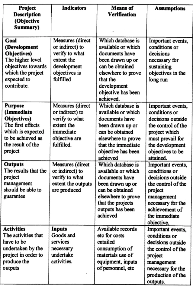
A logical framework consists of four elements. The first of these elements is called narrative or objectives summary. In the 4 X 4 matrix (see table 1.0) the narrative summary is to be found in the first column on the left. Second column is the Perfortnance indicators or objectives indicators. The third column is mean of verification and the fourth column is an assumption.
6
1.5 Objectives of this study
This study is aimed to establish an approach and tool for evaluating and monitoring the Inland Navigation Development at Baram River. Specific objectives of this study include the following: -
i) To study the current practice of Inland Navigation Development in Sarawak especially in the Baram River.
ii) To apply Logical Framework Approach as a tool for improving Inland Navigation condition and Integrated Water Resources Management in the
Baram River.
1.6 Scope of the study
To examine and analyze the current issues and problem, in relation to:
i) Institutional as part for coordination.
ii) Logical Framework Approach Development for improving the Inland Navigation condition at Baram River especially due to current and proposed navigation facilities and other water resources infrastructure development.
iii) Integrating the operation of existing facilities and future infrastructure development.
iv) To develop the first draft of LFA based on the available study reports and information on Inland Navigation in the Baram River.
7
Table 1.0: The Logical Framework
Project Indicators Means of Assumptions
Description Verification
(Objective Summary)
Goal Measures (direct Which database is Important events, (Development or indirect) to available or which conditions or Objectives) verify to what documents have decisions The higher level extent the been drawn up or necessary for objectives towards development can be obtained sustaining which the project objectives is elsewhere to prove objectives in the
expected to fulfilled that the long run
contribute. development
objective has been achieved.
Purpose Measures (direct Which database is Important events, (Immediate or indirect) to available or which conditions or Objectives) verify to what documents have decisions outside The first effects extent the been drawn up or the control of the which is expected immediate can be obtained project which to be achieved as objective are elsewhere to prove must prevail for the result of the fulfilled. that the immediate the development
project objective has been objectives to be
achieved attained.
Outputs Measures (direct Which database is Important events, The results that the or indirect) to available or which conditions or project verify to what documents have decisions outside management extent the outputs been drawn up or the control of the should be able to are produced can be obtained project
guarantee elsewhere to prove management
that the projects necessary for the outputs has been achievement of achieved the immediate
objective.
Activities Inputs Available records Important events, The activities that Goods and etc for costs conditions or
have to be services entailed decisions outside
undertaken by the necessary consumption of the control of the project in order to undertake materials use of project
produce the activities. equipment, inputs management
outputs of personnel, etc necessary for the
production of the outputs.
8
r--
9