Benefits of deploying Oracle9i, Oracle9i Spatial, and Oracle9iAS in online wireless location services. Awareness of the need to exploit these technologies led to the establishment of location services (LBS).
Background ofStudy
Location services (LBS) are defined as applications that provide location information when and where it is needed. Thus, when we talk about wireless location services (Wi-LBS), it actually defines a wireless method of accessing geospatial information through mobile devices or handheld devices.
Problem Statement
Problem Identification
So users have to find other alternatives such as ask other people to know the location. iv). The UTP community including staff, faculty and students still refer to the paper map to find the relevant location within the UTP area.
Significance of the Project
In addition, some information on the maps is not updated, which can cause problems when finding places. v) Take advantage of the capabilities of mobile phones. It meets the needs of the UTP community to find locations in faster and more efficient ways using picture messages via MMS mobile phones.
Objectives and Scope of Study
The Relevancy of the Project
The rationale behind this project is actually to highlight the capabilities of location services to work with MMS mobile phones in sending and retrieving spatial data. Therefore, it could provide a basis for new research studies on the importance of location services.
Feasibility of the Project within the
This study aims to create a wireless location-based services system to meet the needs of the UTP community. Users will receive the result in the form of picture messages via their mobile phones with MMS.
Introduction to Geographical Information
Introduction to Location Based Services (LBS)
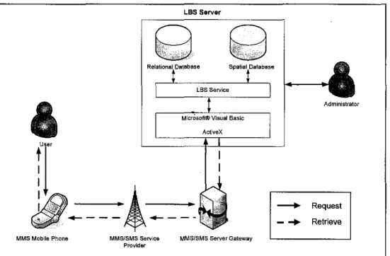
The method used in the development of the system is Rapid Application Development (RAD). This project will go through all phases to come out with the system of wireless location based services. Simple geodata search in the system based on the user's request in the form of regular text messages or SMS.
This is to give the author more focus on the basic processes that are common to all components in the system. It took time for the request to get into the system and the results to be sent to the users. When describing the Wi-LBS system, it is important to understand the tools provided in the system.
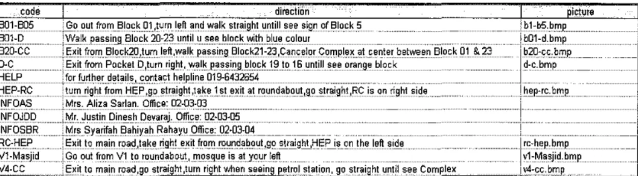
When the request enters the system, a simple lookup of the spatial data is performed to match the entered request with the default request message stored in the system's database Routing table. The system must process the request in sequence based on the time the requests enter the system. This is to divide the system administrator's attention between GIS and wireless.
As mentioned, the study focused on the system's capabilities in performing simple spatial data queries. Analysis to be included in the system for future expansion is Network Analyst and Spatial Analyst.
Short Message Services (SMS) and
Integration ofMMS and LBS Supporting LBS
Wireless Location Based Services (Wi-LBS)
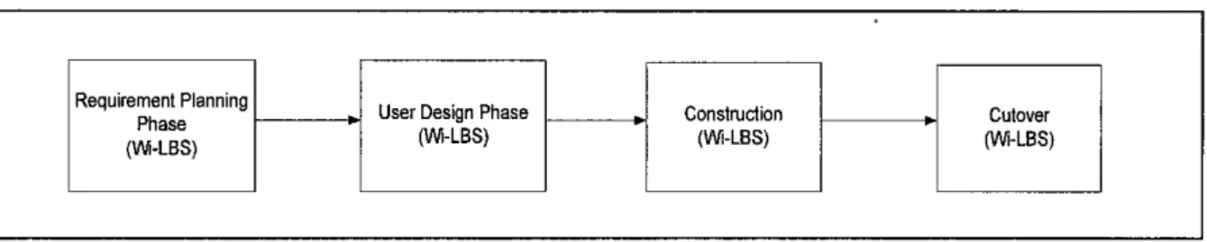
User Design Phase (Design)
Based on the results of research and studies in the analysis phase, the author had come up with the framework of the system, and therefore gives initial views on the workflows for the data transaction in the system. The system will work by receiving requests from users in the form of normal SMS, which are routed to the MMS/SMS Gateway. Installation and configuration of software was also performed during this phase, including ESRI ArcGIS 8.2 and Microsoft Visual Basic.
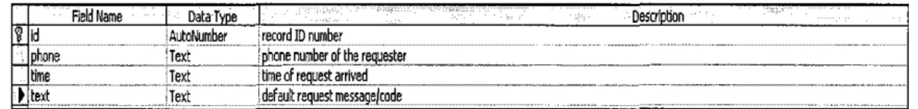
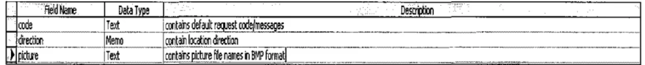
This has provided a basic idea of how the system will look when construction starts later. The database of UTP spatial data was already generated during the creation of the layers. A connection was made to the Microsoft Access database containing table of request codes, response text and respective image or images.
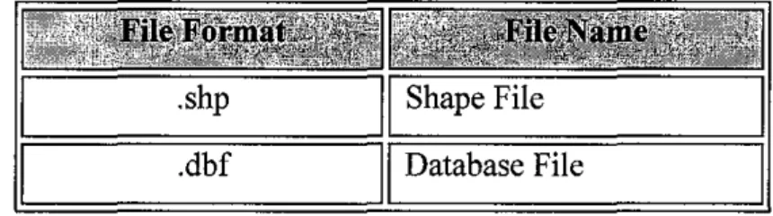
The system was able to export and convert UTP spatial data to an image format such as JPEG, GIF or BMP.
Cutover (Installation and Handover)
At this stage, a manual procedure was performed to ensure a successful connection with the mobile phone. Initial testing was done to confirm this connection using a third-party program called Oxygen Mobile ActiveX Control. This program was able to read and view the data in the Nokia mobile phone.
The main concern was sending picture messages to users' phones that have MMS features at the right resolution. The Visual Basic codes were then modified to enable automatic database searches to match pictorial messages with corresponding request codes sent by users. At this stage, the system has already been fully tested as the final documentation has been prepared to guide end users in using the system.
The system is expected to function correctly and is able to meet user requirements.
Tools
Software Requirement
In addition, RAD also offers greater flexibility in which the redesign process is carried out almost at will. Since RAD is chosen as the methodology, the use of Microsoft Visual Basic 6.0 Professional Edition suits the development of the system. Used for Wi-LBS application development in which wireless messaging controls and ArcGIS 8.2 tools are fully integrated into a single interface and environment.
Microsoft Access 2003 is used as the Database Management Systems (DBMS) software for adding, deleting, editing and managing data.
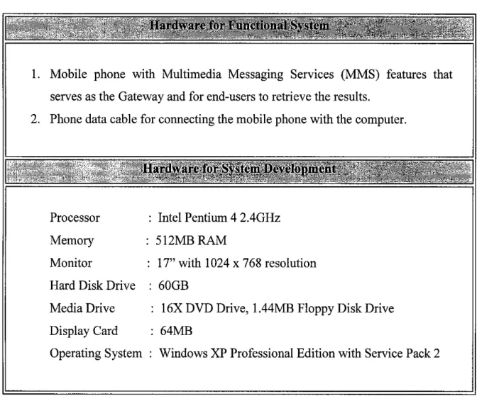
Hardware Requirement
Mobile phone with MMS (Multimedia Messaging Services) capabilities that acts as a gateway and for end users to retrieve the results.
Findings
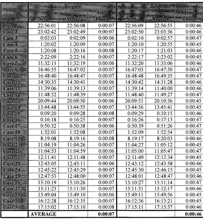
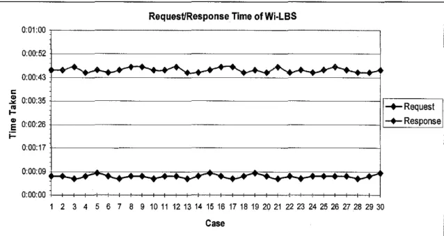
- Request/Response Time
- Integration of GIS and MMS in Wi-LBS
- Wi-LBS System
- GIS Analysis
- ComparisonofMMS and SMS
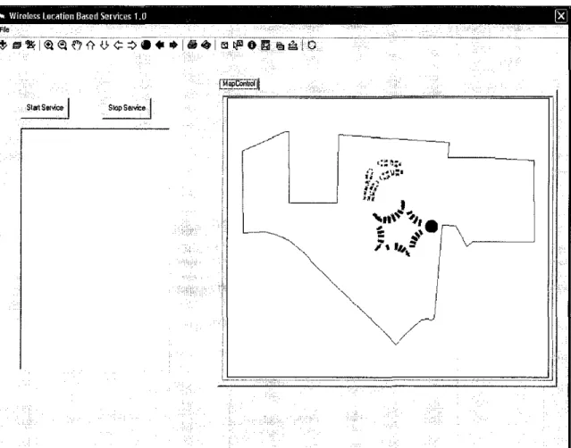
GIS is integrated into the system by inserting these lines of code suitable for Visual Basic for Application (VBA). The administrator runs the system and starts the operation by clicking the 'Start Service' button to connect to the mobile phone. The message 'Operation successful' will be displayed in the list view after the result has been successfully sent.
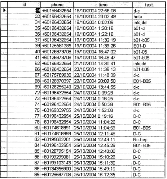
In the case of a new request that is not yet available in the database, the administrator monitoring the transaction will capture a new image based on the new request and the entered information about the new request in the database. When a user sends a request to the system, the request is in the form of a special code that is already defined in the database. The result that matches the code is in the form of a plain text message and an image message.
From the chart, it explains that the location-based services in the form of image and text together could provide a better understanding to provide clear direction from one place to another.
Discussion
Request/Response Time
Higher network coverage results in a faster request sent to the system and a faster result. ii) Network traffic. The process of responding to the request depends on the queuing rule, which means that the system will respond first to the request that comes into the system. iii) Standard request message. Users must send the appropriate standard request message that can match the code stored in the database to ensure that they can get the correct result.
When users send the correct default request message as 'D-C', the system can match it with the same code in the database and send users the correct result. However, if the wrong default request message like 'DC' is sent to the system, the system will respond by sending the 'Request Not Available' message to the user. Incorrect codes or sending default request messages that are not available in the database may result in slower response or the system may not respond at all.
So to ensure that users send the correct default request message, they can send 'HELP' to the system and the system will respond to users by sending text.
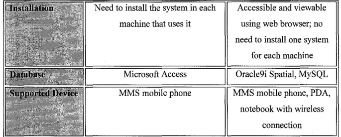
Integration of GIS and MMS in Wi-LBS
The comparisons are based on several products and existing web-based LBS implemented in the USA and several companies in Europe. About half of wireless users and 55% of wireless Internet users were aware of Web-based LBS in 2002. 32% of wireless users and 38% of wireless Internet users are willing to pay a monthly fee for Web-based LBS of up to $10.
Research by The Strategies Group revealed figures on the adoption of Internet-based wireless location-based information by users worldwide from 2002 to 2005. In addition, safety-related services such as roadside assistance and navigation are becoming the most commonly used services. popular services in web-based location-based information. In addition, the increase is also driven by services such as purchasing a ticket from a vendor and accessing accommodation information, which have a major impact on users' acceptance of web-based location services.
In terms of database support, Oracle9i, Oracle9i Spatial and Oracle9iAS Wireless offer high-end features to integrate with web-based LBS.
GIS Search Query
Comparison ofMMS and SMS
So, in implementing Wi-LBS, it is very important to produce location-based information that can be easily understood by users. The needs for Location Based Services are more and more rapid and in recent years, they have been introduced into mobile telecommunication networks. In addition, it shows the possibility and success of wireless and GIS integration in Location Based Services.
In general, wireless location services (Wi-LBS) is a new practical method for searching and retrieving location information using wireless devices. Based on Oracle's white paper "Mobile Developer Initiative - Location Based Services" released in 2002, the paper explained Oracle LBS as a middle-tier component - Oracle9i Wireless. When talking about location-based services, the Global Positioning System (GPS) must be considered.
2003, The study of location-based service in WIN, Beijing University of Posts and Telecommunication, Beijing. 2002, Using Mobile Systems to Send Location-Based Information, Fraunhofer Institute for Computer Graphics, Germany. 2002, Privacy-enhanced architecture for location-based services in the next-generation wireless network, Royal Institute of Technology, Sweden. 2002, Open standards for location-based services. lt;http://www.gisdevelopment.net/teclmology/lbs/techlbs002.htm>. 2002, A model of location-based crime control services.