The Philippine Planning Journal is published in October and April by the School of Urban and Regional Planning, University of the Philippines. The evaluative process involves an examination of the limitations (and potentials) of the entire urban area. The present study has followed the general methodology set out in the threshold analysis manual of the Scottish Development Department.
The geographic object of the study is the city of San Pablo, which stands out for its diversity of topography and surface water. These facts have provided the basis for the selection of the city as a study area. Thresholds imposed by infrastructure services are due to capacity limitations of one or more components in the system.
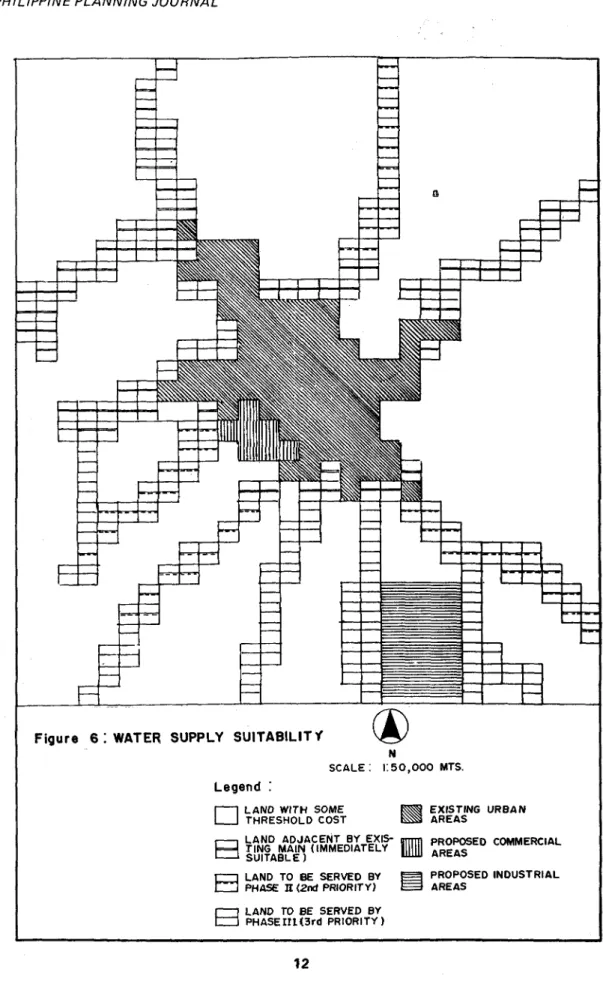
In the first step of the analysis, the water system was subjected to a more thorough and definitive threshold analysis compared to other utilities. The reason for this is the existence of a developed feasibility study for the expansion of the system that will be implemented in
Q]CDO ROAD
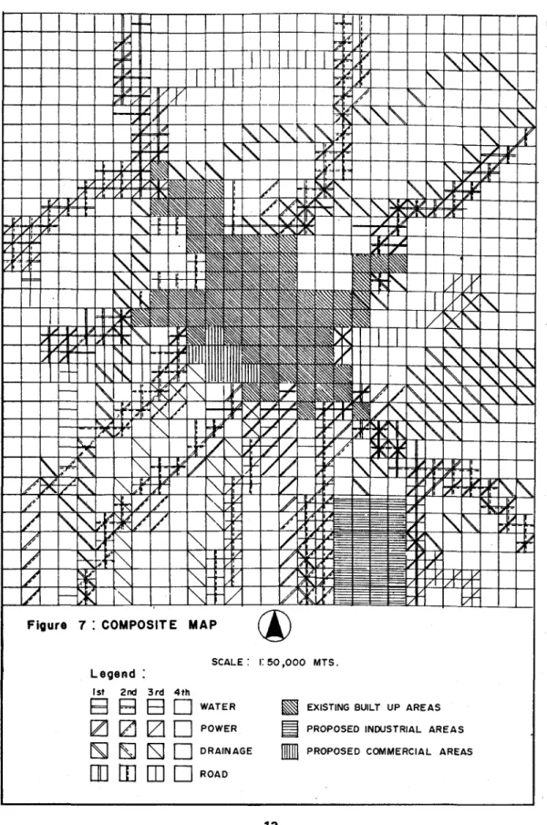
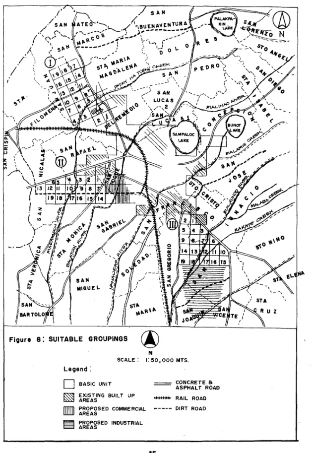
The three identified clusters were further analyzed by isolation and adjustment of the grids (Fig. 8). This adjustment was made on the basis of existing road alignment and proximity of a natural stream for the storm disposal of the groupings. The total threshold costs imposed by the four infrastructure and utilities were calculated on the basis of per capita costs for the selection of the most suitable clusters for the future urban residential areas by the year 2000.
Threshold analysis allows the identification of development constraints or thresholds that limit further physical expansion of the city and the calculation of the costs of overcoming these constraints. In any case, the decision maker will at least know the costs of the alternative in question. Any expansion of these systems will affect the whole city and it is quite impossible to distinguish between the costs for urban and rural areas.
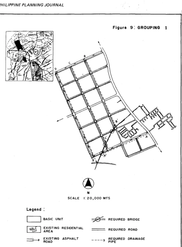
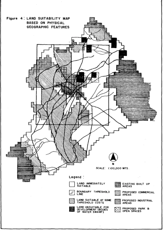
It is also assumed that this situation is a typical case in other cities in the Philippines. Based on the map overlay analysis (physical-geographical factors), urban expansion should be directed to the southeastern part of the city (see Figure 4). Specifically, the urban residential expansion should be located within 170 hectares of Group III (see Figure 8) in the southeastern part of the city.
The proposed industrial site adjacent to Group III should be relocated to the left side of the railway (see Figure 8) closer to the proposed commercial area. Then, the strict enforcement of the location permit system, combined with positive incentives for private developers, should influence the direction of future growth in the identified urban expansion areas. Investing in local capital development is one of the main challenges that the findings of this study pose to the capacity and commitment of the city government of San Pablo.
In this regard, the procedure followed by this study differed from the procedure in the Manual, especially in the way thresholds and potentials were identified using the eco-engineering technique.
IN ANALYZING SOIL EROSION SUSCEPTIBILITY OF THE PHILIPPINES
A number of soil properties and their interaction contribute to soil susceptibility to soil erosion. The depth of the solum (top layer and subsoil) is a very important factor in measuring the susceptibility of soil to soil erosion. The high intensity and amount of rainfall contribute greatly to the problem of soil erosion in the Philippines.
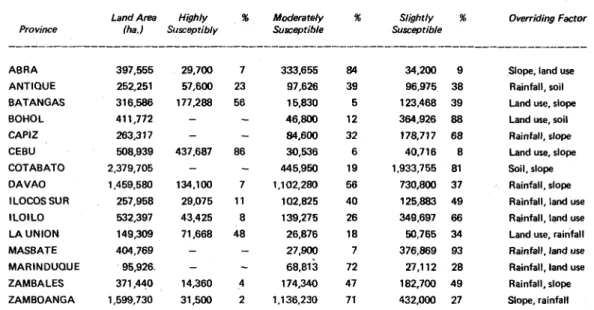
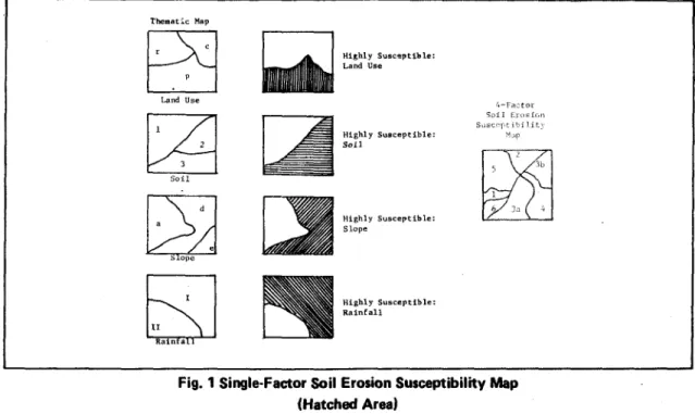
Direct observations of soil erosion are virtually unavailable in the Philippines.4 Yes. Map of soil erosion susceptibility with four factors; - '-not susceptible to soil erosion; 2-Slightly sensitive to soil erosion. Countries with the following slope were classified as highly susceptible to soil erosion:8.
The area marked 1 on the final 4-factor soil erosion susceptibility map is not susceptible to erosion due to the favorable conditions of each of the four factors. An area where any three of the four factors have combined is defined as an area moderately susceptible to soil erosion. Where all four factors combine, an area is classified as highly susceptible to soil erosion.
Residual area of one-factor is classified as susceptible to soil erosion due to unfavorable-. This is indicated by the single factor effect on soil susceptibility to soil erosion. In eight of the fifteen provinces, rainfall was the dominant factor in susceptibility to soil erosion.
This method of determining soil susceptibility to soil erosion is by no means without its limitations.
LAND POLICY: THE CASE OF SANTA ROSA
Each unit of government should adopt a land policy to guide the physical expansion of the city to prevent haphazard and uncontrolled growth and, possibly, overcrowding in the future. It should certainly be anchored in a land use plan that embodies the aspirations and hopes of the residents. In the land use plan, residents can set their own objectives regarding the character of the environment they prefer.
What should be the role of the municipality in the province or region to which it belongs. Through proper implementation of land use planning, urban sprawl can be curbed and incompatible land uses can be minimized. Are measures taken to prevent or minimize the effects of threatening problems?
Have the local officials taken the initiative to formulate policies to provide the direction for the growth of their local communities. The study could also reveal the techniques used to implement the land use plan as well as the nature of the policy adopted to manage the physical development of the city. An analysis was also made of the comprehensive plan and other reports filed with the Office of the Planning Coordinator.
The new Manila South Expressway passes through the rural part of the city, but there was no exit route to Santa Rosa. The jeepneys serve the transportation needs of the residents whose destinations are the nearby towns of Laguna and Cavite. Itspob/acion had 13.4 (or 8,618) percent of the city's population, resulting in a density of 157 persons per capita. hectares, the highest among the barangays.
An essential component of the plan was a land use scheme that stated the city's role in the development of the southern Tagalog region as a member.
MAP: STUDY AREA (SANTA ROSA) AND METRO MANLA
Although power and water supplies were available, these were not under the responsibility of the municipal government. It is understood that the formulation of any policy at the municipal level is the prerogative of the Sangguniang Bayan. The best source of information regarding the land policy (if it existed) in Santa Rosa would be the minutes of the Sangguniang Sayan.
Sometime in 1980, the municipal government of Santa Rosa attempted to establish control over lakefront development. Issuing permits for a number of the mentioned projects could easily be handled by the municipal council. Thirdly, the subdivision plans may not be in accordance with the purposes of the land use plan.
The land use plan has never been the subject of Sangguniang Bayan sessions since its approval in 1980. All three amendments recorded in the minutes of the Sangguniang Bayan were for the expansion of industrial zones. The municipality's planning and development office did not have anyone with a background in urban planning.
The planning office was deeply lacking in vital information relevant to the understanding of the city's physical growth. No system was introduced to monitor the physical changes in the various sectors of the municipality. Analysis of the municipality's municipal income and expenditure pattern and formulation of.
The objectives of central agencies may sometimes conflict with those of local government.
ENVIRONMENTAL QUALITY EFFECTS OF DEVELOPMENT
- THE GLOBAL CONCERNS OVER THE ADVERSE EFFECTS OF DEVELOPMENT
- THE INCLUSION OF ENVIRONMENTAL BENEFITS AND COSTS IN COST-BENE-
- PRODUCTIVITY OR MARKET VALUE TECHNIQUE AND COST-EFFECTIVE-
- THE PROSPECTS FOR THE FUTURE USE OF EXTENDED COST-BENEFIT ANALYSIS
- CONCLUDING NOTE
The implementation of the EIS system in the Philippines and elsewhere in the developing world has been plagued by a number of problems. Another effect beyond the location of the sedimentary and residual deposits in the river system is the increased turbidity of the water, leading to reduced fish production. Some of the techniques that can be used for this purpose are covered in this article.
The IR R is the return or profitability of the project based on the discounted cash flow analysis. Productivity or market value technique - Measures the change in the value of the output using market prices. The value of the incremental production is the measure of off-site effects of the project.
The choice of the two (2) techniques listed above is based on the relative ease and straightforwardness of applying such techniques in quantifying environmental benefits and costs. As might be expected, the industrial development of the coastal region has destroyed the coastal ecosystem. This approximates the negative environmental impacts (in terms of foregone benefits) of Tokyo Bay's industrial and urban developments on coastal marine resources.
SIROUS SALJOUGHIAN ESFAHAN is a graduate student at the School of Urban and Regional Planning, University of the Philippines. He holds a Bachelor of Science degree in Agriculture from the University of the Philippines, M.S. He was the recipient of a British Council Scholarship Grant to attend the Special Course in Urban Planning at University College London.
MANALO is an associate professor of urban and regional planning at the University of the Philippines. She received her Bachelor of Arts degree in economics from the University of the Philippines. She also holds two master's degrees: one in economics from Ateneo de Manila University and the other in urban and regional planning (with specialization in urban planning and estate planning) from the University of the Philippines.