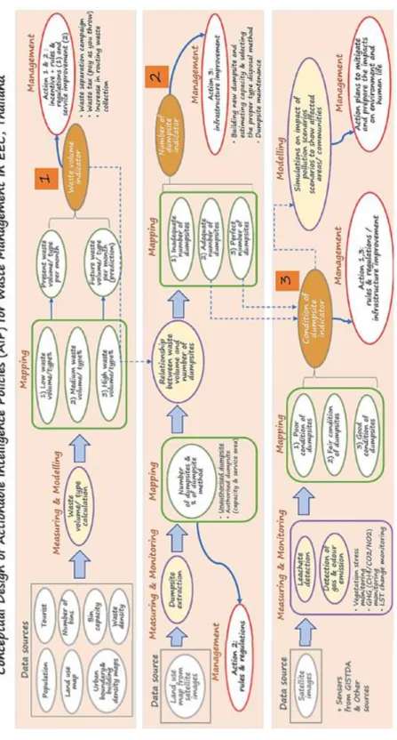
97 Phakphum Soobkampang, Yaowaret Jantakat and Surachart Chaikampha CLOUD COMPUTING, BIG DATA AND AI IN REMOTE BROADCASTING. SPATIAL ANALYSIS OF DROUGHT USING SATELLITE REMOTE SENSING AND GIS-A CASE STUDY IN MONARAGALA DISTRICT SRI LANKA. -Ci Li and Nguyen Dinh Giang Nam. SPATIAL ANALYSIS OF GROUNDWATER DISTRIBUTION AND QUALITY USING GIS AND REMOTE SENSING TECHNIQUES.
ANALYSIS OF THE RELATIONSHIP BETWEEN URBAN HEAT ISLANDS AND LAND USE USING REMOTE SENSING TECHNIQUES (A CASE STUDY OF COLOMBO DISTRICT, . SRI LANKA). TEN-YEAR COMPARATIVE ANALYSIS OF INFRASTRUCTURE GROWTH OF STATE UNIVERSITIES AND COLLEGES IN CARAGA REGION, PHILIPPINES USING REMOTE SENSING AND GIS.
SENSOR AND PLATFORM
2 Institute of Environmental Science and Meteorology, University of the Philippines Diliman, Diliman, Quezon City, Philippines. The main challenge lies in the one-to-one correspondence of the dot pattern matching between the test and the corresponding template. Finally, the SC sets are reconstructed into the WVV set as the same number of the SC sets.
However, knowledge of the Ka-band backscatter from the real sea surface is still poor. In particular, the behavior of the Ka-band backscattered signal is less known for high wind conditions (>20m/s).
ALGORITHM AND IMAGE PROCESSING
1 Training Center for Applied Geodesy and Photogrammetry, University of the Philippines Diliman, Diliman, Quezon City, Philippines,. To increase the robustness of the model, different levels of image enhancement are performed on the samples before training. The proposed trained network can accurately distinguish live from dead corals, which could reflect the health of the corals in the area of interest.
According to the problem, an underwater image seeding and processing scheme is proposed, whose key technologies are object detection model and salient object detection model. In underwater images, the type and number of objects must first be determined, so the underwater object detection model extracts all marine animals in the images, such as fish and turtles. According to the type and number obtained from object detection, the area of the image covered by marine animals can be quickly estimated, and then the image is first screened based on the estimation result.
If the number of sea animals and the obscured area in the image is small, but other parts contain important information, the obscured area of the image will be cropped first. To eliminate the occlusion accurately, it is necessary to extract the exact boundary of the object, as we have already said. The experiment results on the dataset show that our scheme can effectively screen and process underwater images, as shown in Figure 1.
Based on this, the salient object detection model can identify the exact position and boundary of the object in the closed area. The obtained intensity values are influenced by geometric factors and the material composition of the object. In addition, atmospherically corrected Sentinel-2A imagery was also used to compare poplar reflectance values.
Therefore, effective site-specific use of the herbicides is desirable to minimize negative environmental impacts. The algorithm can then retrieve the sub-pixel burn temperature and burn area, along with the surface reflectance of the background.
GEOGRAPHIC INFORMATION SYSTEMS (GIS) AND WEB GIS
1 Department of Mathematics, Physics and Computer Science, Faculty of Science and Mathematics, University of the Philippines Mindanao, Mintal. Environmental issues consisted of (1) the use of chemicals in rice cultivation; (2) the risk of epidemic outbreaks. Tanitharyi is one of the ancient cities where urban development is gradually encroaching on the old city.
This city is also one of the famous tourist destinations in the Central Coast of Vietnam. The aim of the paper is to study the socio-economic conditions of migrant people. The purpose of this study was to explore information about the characteristics of the hotel location and tourism sites.
The area covered by this study is the special region of Yogyakarta, which is one of the main tourist destinations in Indonesia. According to the spatial analysis of ANN and KDE, there is a tendency to cluster. The statement of the issue of municipal waste is discussed together with the ramifications of the analysis.
This study aims to explore information about the spatial and social patterning of the healthcare facility in Greater Jakarta, Indonesia. Mindanao in the south is the second largest island in the Philippines and consumes 13% of the national electricity output. In this study, the focus will be on measuring available head of the 8 Great River Basins in Mindanao.
We modified and adapted the U-Net semantic segmentation architecture to a centroid detection model while maintaining the simplicity of the original model. The experimental results show the effectiveness of the new approach in the combined deep learning model of artificial intelligence. When complete data are available, ensuring completeness and reliability will be a determining factor in the accuracy of prediction and forecasting models.
In this study, Bayesian Regularized Neural Network (BRNN) was applied, the results of the model are evaluated, compared and matched with locations where new landslides occurred. The result of the study allowed the validation of landslide susceptibility models and their significance for local geoenvironmental conditions. Eighty percent of the samples were used to train a Convolutional Neural Network (CNN) model with depth 5 and kernel size 5 x 5 pixels.
This high accuracy strongly suggests that the machine learning method is a good approach for urban land cover classification using very high resolution satellite images. MVC is a suitable method for monitoring plant growth and that is the main purpose of the VLM platform. The calculation algorithm of the steps is explained and discussed in the sections of this article for the recommendations for the next improvement.
In this study, we aimed to investigate the performance of the DeepLabv3+ architecture for building segmentation. The hyperparameters of the architecture have been tested and selected empirically to achieve accurate results. We conduct extensive experiments on the SURFRAD dataset, showing that FCNN+RF significantly outperforms state-of-the-art machine learning methods such as SVR, RF, and FCNN.
DISASTER MONITORING AND PREVENTION
Introduction
Thanh Phu is a coastal district of Ben Tre Province, located in the east of the Vietnamese Mekong Delta, between Ham Luong and Co Chien rivers and occupies 25 km of coastline along the Baltic Sea. However, the impact of climate change in recent years, especially salt intrusion, has greatly affected agricultural production in this district. According to a report from Ben Tre Province in 2016, the salt concentration peaked at 4‰ at the intrusion length of 45-65 km from the river.
The measured salinity at Ham Luong River in Phu Khanh Commune, Thanh Phu District was 6.9‰ at the intrusion length of 25 km from the mouth. The total number of households affected due to lack of fresh water for daily life was 88,208 households with more than 353,000 people across three coastal districts, including Thanh Phu. As one of the coastal districts of Ben Tre Province, Thanh Phu has faced the severe effects of salt intrusion.
Therefore, the research aims to analyze the effect of salt intrusion on agricultural land use at the household level in Thanh Phu District, Ben Tre Province, Vietnam.
Methods
Results and discussion
Conclusion
Accurate flood risk assessment and mapping are one of the main components of flood monitoring and prevention in urban areas. As a result, the utility of the war-damaged tree's blight repellency has been demonstrated. The most severe subsidence occurred in the Huwei, Tuku, and Yuanzhang sections, which were the centers of subsidence of the HSR profile.
The results of this study can be an assessment of the spatial and temporal development of land subsidence in CRAF. Istanbul is one of the megacities where the population is more than fifteen million inhabitants. The Golden Horn is a natural estuary and is located in the old city of Istanbul, which is one of the protected UNESCO sites.
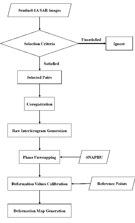
The second region is located west of Istanbul and is vulnerable to slow-moving landslides due to the region's topography and geological structure. In the InSAR analysis, the ALOS-2 image data from the Golden Horn area were processed. The results of ALOS-2 data showed several PS points over the rural parts of the region that could not be determined by Sentinel-1.
The results indicated that most of the old landslides have been reactivated and there are new locations not shown in the current landslide inventory. In the eastern part of the region, a vertical accumulation is identified while the topography decreases. In this study, the first results of the multi-temporal PSI analysis of ALOS-2 over the city of Istanbul were presented.
ENVIRONMENTAL DOMAIN
As for areas with sufficient landfills, the condition of the landfills is assessed. However, there is no detailed model expressly dedicated to environmental resilience in the Malaysian context. As results showed that a percentage of the study area was predicted by wildfire risk in the natural protected area for above each category as follows.
3 Departamento ti Geodetic Engineering, Unibersidad ti Filipinas, Diliman 1104, Filipinas, E-mail: [email protected]. 1 Sentro ti Central Visayas para iti Impormatika ti Aglawlaw, Unibersidad ti Filipinas Cebu, Gorordo Ave. [email protected] ti panagkitana. 2 Departamento ti Biolohikal ken Siensia ti Aglawlaw, Kolehio ti Siensia, Unibersidad ti Filipinas Cebu, Gorordo Ave.
We developed species distribution models for the black shama projected in the current and future scenarios. Results showed localized extinction of the species in the future scenarios with the remaining species populations concentrated near the key biodiversity areas. ANALYSIS OF FOREST COVER CHANGES AND FOREST GREENHOUSE GAS EMISSIONS IN THE PHILIPPINES FROM 2011-2020 USING SATELLITE-DERIVED PRODUCTS.
1 Center for Environmental Informatics, University of the Philippines Cebu, Gorordo Avenue, Lahug, Cebu City, Philippines. This study aimed to identify the effects of ocean tides on groundwater levels in the coastal aquifer of the Taoyuan-Hukou Tablelands, Taiwan. This has shown an increase in forest cover despite a massive human and cattle population.