This special issue on soil erosion invites new and original papers based on physical and chemical theories, field and laboratory experiments, soil analyses, and/or statistical and mathematical modeling that advance our knowledge of dust control and sand stabilization. We aim to report on future progress in the special issue "Soil Erosion: Dust Control and Sand Stabilization", Volume 2.
Soil Erosion and Gaseous Emissions
- Introduction
- Materials and Methods
- Conservation: Effective Measures for Reducing SOC Erosion and Afforestation of Eroded Lands for Sequestration of Atmospheric CO 2 in the Terrestrial Biosphere
- Conclusions
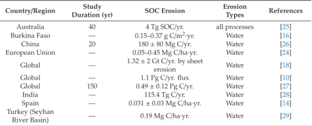
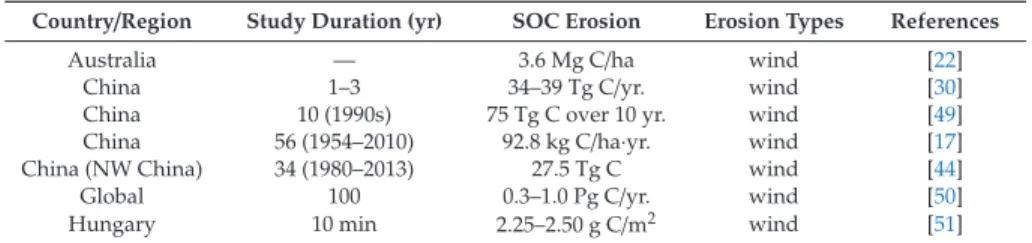
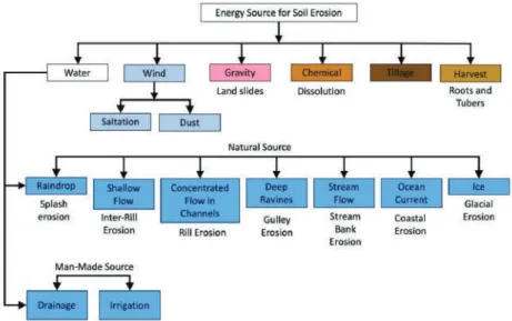
The term "eolian" is derived from the Greek god "Aeolus", the guardian of the wind. Redistribution of soil organic carbon by water erosion - The role of CO2 emissions for the carbon budget. PLoS ONE2014,9.
Can Vegetation Removal Successfully Restore Coastal Dune Biodiversity?
Materials and Methods 1. Study Site
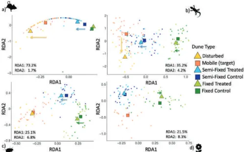
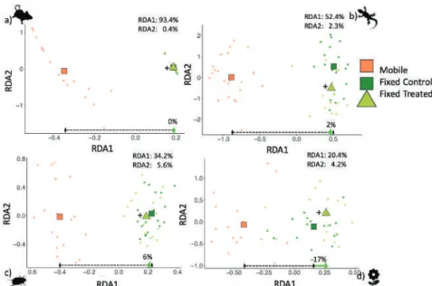
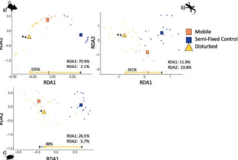
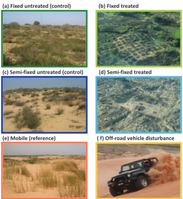
Disturbed dune treatment: Off-road vehicle (ORV) disturbance has occurred illegally in the reserve for many years (Figure 1f), which began before the start of the experimental plots. We then tested whether the effect of the treatments on the eight selected ISs was as expected, i.e. away from the control dunes towards the reference dunes.
Results
All faunal taxa had a significantly different composition over all years in treated semi-solid dunes and (mobile) reference dunes (Figure 8a,d,g). Conversely, disturbed dunes were significantly different from untreated semi-solid dunes in all years (Figure 8c,f,i), indicating turnover (H4a).

Discussion
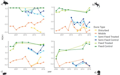
The abundance of this species in untreated semi-fixed dunes was significantly higher than in disturbed dunes in all years.A. Thus, the abundance of this FIS in disturbed dunes was found to be similar to both mobile and untreated semi-fixed dunes in all years (Fig. 12g). Both composition and indicator species showed a temporal trend in the treated semi-fixed dunes, away from the control dunes and towards the reference dunes over time; this trend was more consistent in animal taxa.
Indeed, if the restoration objective was to increase the abundance of MIS, the response to ORV disturbance in the study site could be considered positive. Grazing can be introduced either through reforestation of the ecosystem or in the form of managed domestic grazers [49,135].
Conclusions
Using long-term census data to inform restoration methods for coastal dune vegetation. Estuaries Coasts. Shrub encroachment affects habitat heterogeneity and beetle diversity in a Mediterranean coastal dune system. Land degradation. A field quantification of perennial coastal dune plants as indicators of surface stability, erosion or deposition. Sedimentology.
Vehicle damage caused by recreational use of coastal dune systems in a Special Area of Conservation (SAC) on the west coast of Ireland. Comparing the impact of a grazing regime with European bison versus that with free-ranging cattle on coastal dune vegetation in the Netherlands. Mammal Res.
Characteristics of Aeolian Dune, Wind Regime and Sand Transport in Hobq Desert, China
Study Area
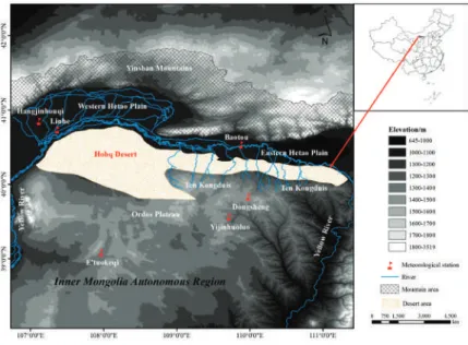
The Hobq Desert is located on the southern bank of the Yellow River and the northern part of the Ordos Plateau in Inner Mongolia, with an area of 1.56×10⁴ km2. The desert is narrow in the east and wide in the west, with a length of about 300 km from east to west. Ten tributaries (flowing tributaries across the desert) flow through the eastern and central Hobq Desert to the Yellow River on its right bank (Figure 1).
Influenced by the East Asian summer monsoon, the average annual precipitation of the Hobq Desert decreased from 400 mm in the east to 150 mm in the west [23]. Precipitation occurs mainly in the form of rain showers and is concentrated from July to September.
Data and Methods 1. Data
The resultant displacement potential (RDP) represents the net DP or the vector sum of the DP values in each compass direction. RDP/DP values close to 1 indicate a narrow unidirectional wind regime, with a single dominant direction of motion, while values close to 0 indicate a multidirectional wind regime with multiple directions of significant motion [3,6] . Specifically, if RDP/DP is less than 0.3, the driving category is complex or blunt bimodal.
The Mann-Kendall (M-K) trend test [27,28] is based on the correlation between the ranks of a time series and their time order. We obtained a mathematical statistical summary of the wind speed parameters using OriginPro20, including standard deviation, minimum value and maximum value.
Results and Analysis 1. Basic Characteristics of Dune
With the M–K test, there was a significant downward trend in the maximum and average annual wind speed at Dongsheng station during 2009–2018 and had a pause in 2013. At Hangjinhouqi and E'tuoke stations, there was a significant upward trend in the average annual wind speed and had a pause in 2017 and 2012, respectively. Figure 6 shows the distribution of mean and maximum annual wind speed in the desert and adjacent areas from 2009 to 2018.
From the overall wind speed distribution, the average wind speed of the prevailing winds of each station from 2009 to 2018 was mainly distributed by 4–8 m/s. However, the frequency percentage of wind speeds above 10 m/s at each station was very low, with a maximum value of 10% or less.
Discussion
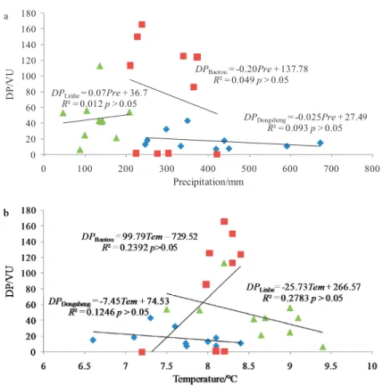
The relationships between the calculated DP and (a) annual precipitation (Pre) and (b) annual mean temperature (Tem) from 2009 to 2018 at three representative weather stations in the Hobq desert. However, the relationships between DP and the annual precipitation and temperature at all the stations from 2009 to 2018 were not significant (p>0.05). The modern environmental monitoring of the Maowusu Sandy Land, which is located in the south of the Hobq Desert, shows that the vegetation recovery capacity of the east and west of the Maowusu Sandy Land was not synchronized with the decreasing wind, decreasing anthropological activities and slightly increasing precipitation.
This suggests that the response to climate change in the eastern and western regions of the Hobq Desert may also be out of sync. Meanwhile, through the study of the sedimentary sequence of the layers in the Hobq desert, it is found that the formation of aeolian sand in some sections is mainly related to the increase of available loose sand resources and not to the dry climate conditions [23].
Conclusions
Analysis of characteristics of channel development in the Hobq desert in the depth of the Yellow River. Response of hyperconcentrated flow to eolian and fluvial interactions from a desert watershed upstream of the Yellow River. Catena. Long-term morphodynamic changes of the desert part of the Yellow River after the operation of large reservoirs upstream. Geomorphology.
Spatial and temporal changes in aeolian sediment input into the tributaries (Ten Kongduis) of the upper reaches of the Yellow River. Aeolian indeed. Changes and influencing factors of sediment load in the Xiliugouba Basin of the upper reaches of the Yellow River, China. Catena.
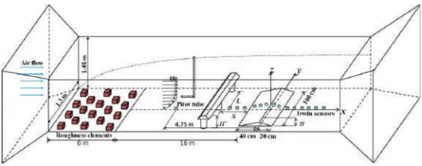
Wind Tunnel Measurements of Surface Shear Stress on an Isolated Dune Downwind a Bridge
Methods
Figure 5 shows the spatial variability of the mean value of normalized surface shear stress (τ) on the sand dune and downstream. In addition, the wall shear stress downwind of the sand dune is not affected by the bridge in the case of S=10.0 H and 20.0 H. Compared to the isolated dune case, the surface shear stress on the windward slope is reduced by the shelter of the pier (except on the two points at the beginning of the windward slope).
In the case that S is equal to 20.0 H, the wall shear stress sheltering effect almost disappears. The results showed that the average wall shear stress on the windward ridge of the sand dune with the bridge decreases in the cases of S=1.5 H, 3.0 H and 5.0 H.
Using Post-Harvest Waste to Improve Shearing Behaviour of Loess and Its Validation by Multiscale
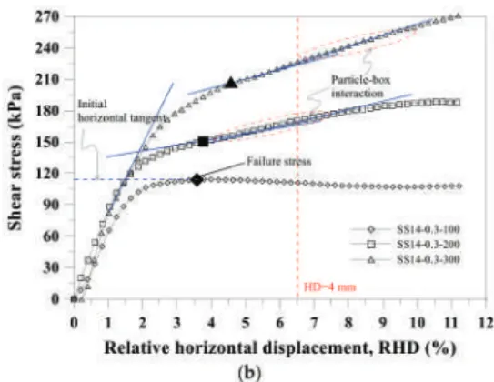
Results and Discussion 1. Definition of Failure
The more PHW is added, the greater the effect of particle entanglement and the less the importance of the scale effect. The effect of particle interlocking inhibited the development of shear bands in the vicinity of the shear plane. The smaller the amount of water added to the loess-PHW mixture sample, the greater the difference in RHD and the greater the importance of the scale effect.
Thus, this effect hindered the development of shear bands near the shear plane as HD increased. The improved shear behavior of the loess-PHW mixture was attributed to the effect of particle entanglement and this effect kicked in when the water content reached a threshold, i.e. gt;14%, which facilitates particle rearrangement.
Biostimulation in Desert Soils for Microbial-Induced Calcite Precipitation
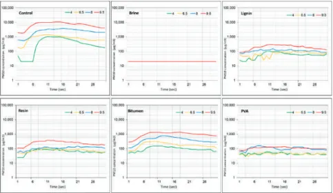
Stimulation of urea-hydrolyzing bacteria was evident in soil incubated in the presence of urea and a carbon source (yeast extract), as shown by pH increase and urea degradation (low yeast extract concentrations (YE_L) and high yeast extract concentrations (YE_H)). Low yeast extract concentrations (YE_L) resulted in ineffective stimulation compared to high yeast extract concentrations (YE_H) in the two soils studied. As expected, the pH of the negative control samples from the two sites remained unchanged, and urea concentrations were negligible throughout the biostimulation experiment (Figure 3, AGW).
We found that indigenous urea-hydrolyzing bacteria are naturally present in desert soils and can be easily stimulated to achieve effective urea hydrolysis and calcite precipitation within days. To conclude, the results presented above indicate that desert soils from the Rotem Plateau of the northern Negev desert (Israel) are susceptible to biostimulation by indigenous ureolytic bacteria.

Comparison of Diverse Dust Control Products in Wind-Induced Dust Emission from Unpaved Roads
Materials and Methods 1. Laboratory Experiment
After this process, the amount of the solution (water content) was very different between the soil samples/applications. Note that the composition of the solution of each substance and the concentrations of the solution to be applied by spraying to the soil surface have been provided by the suppliers. The soil samples in trays after the application of the dust control product used for the laboratory wind tunnel experiment.
A typical unpaved transport road (~200 m long) from the quarry was used for the dust control experiment. Application of the dust control product on the unpaved transport road before the dust emission experiment.
Results and Discussion
The calculation was based on the dimensions of the wind tunnel and the surface of the soil [23]. In the lower part of the table, the dust suppression efficiency (%) is calculated as a ratio in dust flow between the treated road section and the check road (untreated). The results of the PM10 dust emission from the soil samples of the field experiment are shown in Figure 6.
The high efficiency of magnesium chloride solution (Brine) in suppressing dust emissions due to vehicle transport was already reported [18,24]. These studies showed the high efficiency of brine to reduce dust emission due to the movement of vehicles (wheels).
A Clay-Based Geopolymer in Loess Soil Stabilization
The activating solution was added to the soil mixture in a supersaturated state until the mixture reached a shedding state. The recorded PM10 concentrations are the result of dust emission from the surface of the loess soil samples at two wind speeds. The results of the test for soil samples stabilized by the geopolymer with different amounts of CaO in the activation solution are shown in Figure 3b.
However, the results of the NaOH in the activation solution (Figure 3a) are significantly higher than those of the replacement base (CaO) with 30% MK (Figure 3a). The application of the geopolymer for dust control in loess soil compared to conventional products (brine, bitumen, PVA) resulted in no dust emission.