University of KwaZulu-Natal (Howard College Campus) School of Built Environment and Development Studies
Research Topic:
Assessing the level of stakeholder engagement during Boundary Demarcation and Ward Delimitation. Case study of Ndwedwe Local
Municipality
By
Zukiswa Nolufefe Nguza (211517073)
Supervisor: Mr V Myeni
This dissertation is submitted in Partial Fulfilment of the requirements towards the degree of Master of Town and Regional Planning in the School of Built
Environment and Development Studies.
2016
I, Zukiswa Nolufefe Nguza hereby declare that this dissertation is my own unaided work, except where otherwise acknowledged in the text, and it has not been submitted in whole or part for any examination or degree at any University.
Student: ___________________________
Signature: __________________________ Date: ________________
i Acknowledgements
“All things work in favour of those who love the Lord. “ I have been highly favoured and grateful for the opportunity afforded to me by the Lord, the endless endurance and perseverance in hard times of conducting my thesis.
This dissertation is dedicated to my mom and dad (Nohombile and Mzingisi Nguza) who have supported me endlessly with no complaints throughout my studies and may God bless you.
My sister (Vuyo) who has been there through the highs and lows, and has provided information and great channels of communication with stakeholders.
To my friends and family, thank you for your support and prayers.
This dissertation wouldn’t have been successful without my wonderful Supervisor Mr V Myeni, whom I learnt to hate and love in such wonderful way. Your guidance, and love for what you do has encouraged me to aim high and work consistently. Thank you for lending an ear when I had this burning topic and showing interest. Thank you for being part of laying a foundation for my future.
Sincere gratitude to Mr BK Ntuli who encouraged me to embark on this discipline, the knowledge and support you’ve given me is immeasurable.
Great thanks to Ndwedwe Local Municipality (Ms Cibane) and the MDB official (Liz Mazibuko) for providing sufficient information to carry out my research may God Bless you.
ii Dedication
This Town and Regional Planning Masters dissertation is dedicated to my parents, Mrs Lilian Nohimbile and Mr Comfort Mzingisi Nguza. Thank you for believing in me and for the infinite love and support.
iii Acronyms
ANC: African National Congress
EC: Eastern Cape
GIS: Geographic Information System IDP: Integrated Development Plan
IEC: Independent Electoral Commission IFP: Inkatha Freedom Party
KZN: KwaZulu-Natal
MDB: Municipal Demarcation Board
MEC: Member of the Executive Committee NLM: Ndwedwe Local Municipality
SALGA: South African Local Government Association RSA: Republic of South Africa
SDF: Spatial Development Framework
UK: United Kingdom
iv Abstract
Creating a sense of belonging for oneself and for a community is a fundamental requirement for human security and resource allocation. The sense of security as referred to in the latter can be in the form of boundaries which mark the territorial segments of an area characterized by different variables, such as the same ethnic group, clan names, and can further be seen as economic, administrative and political representation. During the apartheid regime, boundary demarcations such as ‘homelands’ and ‘group areas’
were used to maintain and enforce political control. However since the demise of the apartheid government, South Africa went through a period of bringing about change and amongst many, was social change, racial inclusivity, encourage integration as well as address land tenure and reform. The post-democratic period in 1994 represented a plethora of legislation and policies that came into effect to undo the scars engraved by disintegration of the apartheid system.
To achieve this, the South African government then demarcated municipal administrative bodies guided by the constitution. Municipalities were further divided into smaller segments of wards to help redress the social and spatial inequalities inherited from the apartheid government, as well as help speed service delivery, where in 1998, the Municipal Demarcation Board acted as an independent organ responsible for carrying out demarcations. As an independent body, it has been prevalently faced with many challenges, many of which where their processes have been perceived as being biased in the sense that municipalities with communal land have suffered most. The demarcated democratic local authorities, as well as the long standing traditional authorities have created an overlap of arms of authority and have caused a lot of confusion amongst community members, and this has affected service delivery. In many instances this has led to boundary disputes that members of the community have expressed in an aggravated manner of riots and burning of community and social facilities.
The study aims to determine whether or not the result of boundary disputes is caused by the lack of stakeholder engagement during the process of boundary demarcation and ward delimitation. By doing so, the study seeks to accomplish objectives of identifying the drivers of boundary disputes and how they can be resolved, as well as unpack the
v
challenges associated in the process of boundary demarcation and ward delimitation and the key stakeholders involved in both areas.
As a tool of collecting and analyzing data, this study has reviewed literature that focused on collaborative planning, territoriality as well as the inclusionary theory. This study has also reviewed government legislations and policies, and has used the latter in analyzing data obtained from the study area though a qualitative method of data collection in the form of interviews questionnaires and focus groups. In order to help speed service delivery, alleviate disputes and ensure good governance, this research study has been interested in investigating the causes of the disputes and the level of stakeholder engagement in the processes carried out by the MDB, using case studies, theories and legislative frameworks, as tools of evaluating and analyzing the demarcation and delimitation processes.
The study found that the advancement of institutional criterion that governs the changes of boundaries in their respective hierarchies, has caused confusion to various
stakeholders. This has also been primarily caused by the lack of insight in these
geographic processes and the pieces of legislation that govern the process of boundary demarcation and ward delimitation. However the study concluded that the MDB has made means of consulting with municipalities and affected stakeholders in their
processes, however the affected stakeholders felt that decisions weren’t in their favor.
The study then recommended that responsive environments in local government and stakeholder engagement be created, as well as help strengthen the relationship between the stakeholders and the MDB, in which could be assisted by reviewing the criterion currently governing the demarcation processes.
Table of Contents
Dedication ... ii
Acronyms ... iii
Abstract ... iv
List of Diagrams ... iv
List of Graphs ... iv
Chapter 1: Introduction and Research Methodology ... 1
1.1 Introduction ... 1
1.2 Problem Statement ... 3
1.3 Objectives ... 6
1.4 Main Research Question ... 7
1.5 Sub-Questions ... 7
1.6 Hypothesis ... 7
1.7 The definition of key concepts ... 8
1.7.1 Municipal Wards ... 8
1.7.2 Stakeholder Engagement ... 8
1.7.3 Demarcation ... 9
1.7.4 Delimitation and Delineation ... 10
1.7.5 Wall-to-wall Demarcation ... 11
1.8 Study Justification ... 11
1.9 Research Methodology ... 13
1.9.1 Qualitative Research Method ... 14
1.9.2 Case Study Research Method ... 14
1.9.3 Primary Data ... 14
1.9.4 Secondary Data ... 17
1.10 Data Analysis ... 17
1.11 Limitations of the Study ... 17
1.12 Structure of the dissertation ... 18
Chapter 2: Theoretical Framework and Literature Review ... 19
2.1 Introduction ... 19
2.2 Theoretical Framework ... 19
2.2.1 The Theory of Territoriality ... 19
2.2.2 Collaborative Planning ... 22
2.2.3 The Inclusionary Theory ... 24
2.3 Literature Review ... 26
2.3.1 The Importance of Municipal Wards ... 26
2.3.2 Boundary Demarcation and Stakeholder Engagement ... 31
2.4 Legislative Framework Related to: Demarcation and Local Government ... 33
2.4.1 The Constitution of the Republic Of South Africa, 1996 (Act No.108 Of 1996) ... 34
2.4.2 The South African White Paper on Local Government, 1998 ... 35
2.4.3 Local Government: Municipal Structures Act (No. 117 of 1998) ... 36
2.4.4 Local Government: Municipal Systems Act (No. 32 of 2000) ... 37
2.5 Approaches Towards Stakeholder Engagement in Demarcation and Delimitation ... 37
2.5.1 Gearing Towards Integrated Development ... 37
2.5.2. Public Engagement and Outreach: As a tool for stakeholder engagement in demarcation and delimitation processes ... 39
2.6 Conclusion ... 41
Chapter 3: Historical Background of the Case Study ... 42
3.1. Introduction ... 42
3.2. Geographical Location of Ndwedwe Local Municipality ... 42
3.3 Historical background of Ndwedwe Local Area ... 43
3.4. Contextual Analysis of Ndwedwe Local Municipality ... 43
3.5. Socio-economic Status of Ndwedwe Area ... 44
3.5.1 Population Demographics ... 44
3.5.2 Educational Level of Ndwedwe Area ... 45
3.5.3 Economic Activities ... 45
3.5.4 Transport Modes and Networks ... 48
3.6 The Availability of Amenities ... 48
3.7 Moving Towards Sustainable Development ... 49
3.8. Conclusion ... 49
Chapter 4: Research Findings, data analysis and interpretation ... 51
4.1 Introduction ... 51
4.2 Awareness of Boundary Demarcation and Ward Delimitation ... 52
4.3 Boundary Changes in Ndwedwe Local Municipality ... 54
4.4 Dissatisfaction on Service Delivery ... 55
4.4.1 MDB Official ... 56
4.4.2. Municipal Official ... 56
4.4.3 Ward Councillors and Traditional Authority ... 58
4.5 Ward and Outer Boundary Disputes ... 58
4.6 Stakeholder Engagement and Good Governance ... 60
4.7 Conclusion ... 62
Chapter 5: Summary of Findings, Conclusion and Recommendations ... 63
5.1 Introduction ... 63
5.2 Recommendations ... 65
5.2.1 Creating a Responsive Environment in Local Government for Stakeholder
Engagement ... 65
5.2.2 Strengthen the relationship between Stakeholders and MDB ... 66
5.2.3 Reviewing MDB criterion for ward delimitation and outer boundary demarcation. ... 67
5.3 Conclusion ... 67
References ... 69
Appendix ... 78
List of Diagrams Diagram 1: Boundary Change Diagram………..59
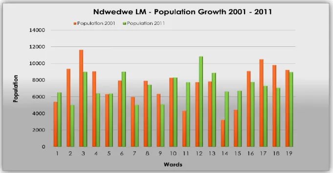
List of Graphs Graph 1: Population Growth……….44
Graph 2: NLM Occupational Types……….46
Graph.3: Ndwedwe LM- Levels of Unemployment 2001- 2011………..47
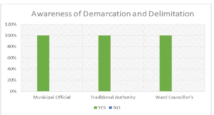
Graph 4: Awareness of Demarcation and Delimitation ……...………53
List of Figures Figure 1: Limpopo protest about boundary changes………..………38
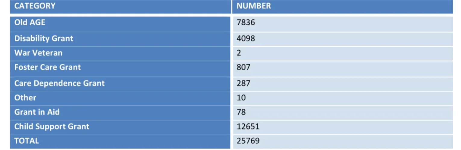
List of Tables Table 1: Social Grant Dependency……….48
Table 2: Showing Wards subject to boundary changes………...……54
Table 3: The Effects of Service Delivery in MDB Processes……….………….……56
Table 4: Showing the Roles Played by each Stakeholder….………..60
List of Maps
Map 1: Locality Map
Map 2: Ndwedwe Local Municipality Boundary Changes Map 3: Draft Wards Ndwedwe (KZN 293)
1
Chapter 1: Introduction and Research Methodology 1.1 Introduction
A fundamental cornerstone in association with human security is the possession of adequate and secured land rights for all citizens in a country (Luthuli, 1958). The latter trickles down from the sense of belonging, in a hierarchal perspective of the country, the province, the district and municipal ward. To belong in such realms requires marked territories in the form of boundaries; to facilitate the unforeseen social, economic and political uncertainties that could occur. This then brings about, the notion centered around the concept of boundaries and their distinct role in society as a whole.
A boundary is referred to as a dividing line that marks the limits of an area. Boundaries are commonly regarded as being natural (or physical) social or political, and mark territories that divide people, contextually based on specific criterion (Nxumalo, 2013).While Boggs (1940) defines boundaries as being geometric (through their shape and orientation) and physical (natural features), Broek (1940) inherited the idea that a boundary could be natural, based on man-made political phenomenon and that its definition does not entirely depend on a physical aspect. Broek (1940) emphasized that the long hierarchy of authority in an area, tends to weaken that authority, and makes it more susceptible it is to problems of service delivery, hence why the need for ward boundaries that further divides districts and municipalities. The purpose of this study focused on how the demarcation of boundaries remains a contested issue because of the lack of stakeholder engagement, looking closely at the delimitation of ward boundaries of Ndwedwe Local Municipality.
During the South African the system of apartheid, the demarcation of boundaries such as
‘homelands’ and ‘group areas’ were used to maintain and enforce political control. This was based on racial zoning and a segregationist form of planning (Nxumalo, 2013).
African blacks were placed in the hinterlands and underdeveloped areas, whilst whites lived in the more developed areas. However the introduction of the democratic era in
2
1994, South Africa went through transformation, which aimed to redress racial inequalities experienced in the previous government system and socially change the country.
Subsequent to this change, was the demarcation of provincial boundaries by the state as well as the demarcation of municipal boundaries by the MDB. This demarcation of local municipal boundaries (local government) was aimed at addressing the spatial legacy that was inherited from the past, as well as help speed service delivery (Mavungu, 2011). In essence this sought to counter the top-down approach to accommodate a more community-based approach that included the engagement of all stakeholders and that translated the premise of a theoretical framework, of planning for communities and with the community.
According to section 3 of theLocal Government: Municipal Demarcation Act, 1998 (Act No 27 Of 1998), the Municipal Boundary Demarcation Board, is a juristic individual, is autonomous and must be unprejudiced and perform its capacity without fear, support or partiality (www.demarcation.org.za). It determines and re-determines municipal boundaries, delimits wards, for local elections and empowers municipalities to fulfil their constitutional obligations. According to the MDB (www.demarcation.org.za), this is done fundamentally to upgrade a law based and responsible local government that gives productive, powerful and maintainable administration conveyance inside of sound boundaries. However the demarcation of boundaries is a contested issue, simply because it redistributes political power and is prevalently polarizing the functioning of local government (Khan et al, 2010).
It is integral to acknowledge that demarcation and delimitation are concepts that are used in correspondence, but for the roleof electoral management, the re-determination or reconfiguration of outer municipal boundaries are called demarcation, and delimitation is the process of drawing (either delimiting or annexing) local ward boundaries. Given the MDB’s sovereignty, it quests the role played by stakeholders in the community, more specifically, tribal authorities, ward councilors, committees and the community as a whole (Nxumalo, 2013). While municipal boundaries excluded the tribal areas in the past, the new demarcation in terms of the Demarcation Act, introduced wall-to-wall municipal
3
boundaries. This meant that the tribal rural areas were incorporated into municipal boundaries. Thus when referring to single wards, there exists a manifestation of different authorities, which are in reality an implication of political geography, where different authoritative bodies overlap in one boundary (Ntsebeza, 2003).Literature reveals that insufficient public participation of influential stakeholders, like the rural community, the ward councilors and committees are often separated by municipal and ward boundaries, and have failed to follow an array of existing social boundaries (Putu, 2006). It is therefore mandatory that MDB devotes itself to alluring with members within the community to find better ways to meet social, economic and material needs and promote sustainable livelihoods (RSA, 1998, Section B).
This dissertation has therefore assesses the level of stakeholder engagement, and how incorporating various stakeholders in the process of delimitation of wards can result to more sound boundaries, avoid disputes, and good service delivery. This study has looked at lessons that can be learnt, using the case study of Ndwedwe Local Municipality, located in the province of KwaZulu-Natal.
1.2 Problem Statement
In order to make provision of services to different communities in a way that doesn’t discriminate or compromise its availability to others, the implementation of the Municipal Demarcation Act No 27 of 1998aimed to create municipalities with outer boundaries that defined the spatial extent. With the delimitation and demarcation of municipal boundaries and wards, there are layered issues (administrative, social and political) that arise from the processes. In some scenarios, this is not the case, as other councilors and municipalities are not affected, with the premise that the process brings with it an amelioration of service delivery (Nxumalo, 2013).
On the contrary are others whom are affected otherwise, where lack of stakeholder engagement prevails (where there is lack of proper engagement with the community, and traditional authorities), where stakeholders in society feel demarcation, and the
4
delimitation of their wards and municipalities are a form of compliance and not a consultative one and therefore ignores existing social boundaries. The incorporation of homelands through the municipal-wall-to-wall demarcation experienced problems from a sociological point of view (Nxumalo, 2013), where social boundaries, which are boundaries that mark territories of class, culture, history and ethnicity were often not considered in the demarcation processes (Fourie, 2000). In this regard, the latter has fueled animosity amongst municipal officials and community members, where the municipality exercises a limited degree of autonomy in decision making, during the process of ward and municipal boundary changes.
A contributing factor to ensuring a good municipality is engaging with the community and ensuring it is satisfied, as municipal wards are the basic building blocks to the system of local government and the conduit of service delivery. According to the Parliamentary Liaisons Office (2013) the restructuring of municipalities is important because it is an opportunity for South Africans to share their resources, to promote equality, reconciliation and nation-building. Although the redetermination of municipal boundaries could be perceived as stated in the latter, there are other layers that cloud the process of boundary demarcation, such as: the reduction in the number of municipalities could lead to fewer councilors, and could easily become an acute struggle for jobs and with insufficient public participation by rural communities, complex social boundaries more especially in traditional tenures, that could fuel violence of communities split by municipal or ward boundaries.
According to McCall (2003), boundary disputes have also prevailed in Tanzania, in Kisanga village, where boundary disputes occurred because of land tenure insecurities.
McCall (2003), adds that the roots of boundary disputes in Kisanga are due to poor demarcation of boundaries that have ignored existing social boundaries. Although the latter has prevailed, and although geospatial boundaries were not clear, most people were quiet certain of their boundaries based on landmarks, more especially the older generation of the community. In Matatiele, boundary disputes are still unresolved, where many people living within the Matatiele municipality wanted to be within the KwaZulu
5
Natal (KZN)boundary, rather than Eastern Cape (EC) where it has been located since 2005 (www.gisesri.com). In Matatiele, incidents of violent confrontation have been less prevalent. However, the dispute has polarized the local community with pro-KZN and pro- EC residents showing deeply felt animosity towards each other. Four years of contestations over the Matatiele provincial boundary have seen three constitutional Court challenges brought against the government (Mavungu, 2011). In one instance, the Court ordered a rerun of a lengthy legislative process to correct the deficiency of public participation in the initial 2005 legislative process (Mavungu, 2011).
Issues centered on boundary disputes are not only experienced in the African continent, but also abroad, where in Indonesia they experienced boundary disputes, after a demarcation process that took place and left the inhabitants of Indonesia unhappy, after its period of decentralization, which triggered the formation of new regions and regional boundaries (Joyosumarto et al, 2014) which are contextually referred to as provincial boundaries. Boundary disputes in Indonesia emanated from the insufficiency of geospatial information that was used during the demarcation process that ended up being translated into blurred and unclear boundaries that ended up being ambiguous (Joyosumarto et al, 2014). The latter supports that the attributes that constitute as factors that have been said to have caused boundary disputes, which is also contextually relevant, given controversies that have been taking place in South Africa in the post democratic era, and prevalently in preparation for local elections at the ward level. The issue of insufficient geospatial data and lack of insight of social boundaries that exist on the ground, can be said to be an evident problem in boundary demarcation as witnessed in the context of both Indonesia and South Africa, which also bears witness of lack of integrated development planning and ignorance of the premise that guides planning theory, of planning with and for the people.
Post-apartheid South Africa has been plagued by recurrent provincial and ward boundary disputes that have been led to oppositions between the government and local communities, in areas such as Bushbuckriddge, Khutsong, Matatiele, and Balfour (Mavungu, 2011). Prevalently these oppositions have been witnessed in Malamulele,
6
where the area was deemed unsuitable to be awarded municipality, based on specific criteria that governs an area to be granted a municipality. There is thus a need for deeper understanding of these territorial conflicts to facilitate adequate prevention or swift resolution. Often the aftermath of the announcement of annexation of boundaries is fueled by both the lack of stakeholder engagement and lack thereof the process of ward delimitation.
Ndwedwe Local Municipality, which is the study area consist of vast land that falls under the Ingonyama Trust, and given the wall to wall demarcation that was introduced by the MDB, meant that any form of development that takes place in Ndwedwe Local Municipality was to be incorporated into the development frameworks of the municipality.
Given the changes in which the MDB has proposed in preparation for the 2016 local elections, there are implications that come with it, some of which mean that current ward councillors would be merged into other wards, as well as the conflict in which it has with traditional authorities. That not only posed contestation of power struggles amongst ward councilors, but also posed insecurity amongst the members in a community as well as the political conflict that comes with the cost of changes in boundaries. This study has focused on ward 15, where conflicts of land ownership, and insecurities amongst various stakeholders prevails.
In exploring these instances of provincial boundary disputes and territorial issues as discussed in the latter, it is evident that there is lack of involvement of the community and various affected stakeholders, with regards to the processes carried out by the MDB. This dissertation used the case study of Ndwedwe Local Municipality, drawing form the disputes caused by ward delimitation processes by the MDB.
1.3 Objectives
The study seeks to accomplish the following objectives
1.3.1 Investigate the causes of boundary demarcation and ward delimitation disputes.
1.3.2 Identify the drivers of these boundary disputes and how they can be resolved.
7
1.3.3 To identify how disputes have limited the rights and responsibilities of various stakeholders, such as: Municipalities, Councillors, and Traditional rural community.
1.3.4 To unpack the challenges that are associated with the process of boundary demarcation.
1.3.5 To assess the level of stakeholder engagement during the process of ward delimitation.
1.3.6 To review literature on the best practices of boundary demarcation and ward delimitation.
1.3.7 To identify the key stakeholders in boundary demarcation and ward delimitation.
1.4 Main Research Question
To what degree has the MDB been able to engage key stakeholders during the process of boundary demarcation and ward delimitation in South Africa?
1.5 Sub-Questions
1.5.1 What are the causes of boundary demarcation and ward delimitation disputes?
1.5.2 What are the drivers of the boundary disputes and how can they be resolved 1.5.3 What is the role played by the municipality in the demarcation of boundaries?
1.5.4 What is the role played by the community, in the demarcation process?
1.5.5 What role do tribal authorities play in the delimitation process?
1.5.6 What challenges are associated with the process of boundary demarcation?
1.5.7 At what stage do stakeholders get engaged with the process of demarcation and delimitation of boundaries?
1.6 Hypothesis
Stakeholder engagement during the demarcation of boundaries and ward delimitation by the MDB can help improve the process by reducing disputes and conflicts.
8 1.7 The definition of key concepts
The following concepts formed the basis of this dissertations’ focus. These are concepts that were referred to be used interchangeably and frequently throughout the dissertation, and it was therefore integral to gain insight of their meaning.
1.7.1 Municipal Wards
Wards are segments of local government that deepen local governance and are the building blocks of ensuring good governance, translating directly what the community aspires (Sibiya, 2011). In order to enhance the political and administrative structures of a municipality, ward committees play the role of assisting elected ward councilors and in turn all bridge the gap between the municipality and the community (MDB, 2015).
Municipal wards have elected ward representatives (committees) that work together with the community and the municipality. “The representatives help enhance the engagement within the local community in making municipal decisions and offer a direct link with the council” (Sibiya, 2011). With regards to the “Municipal Systems Act, local government is expected to involve communities in their area of jurisdiction in addressing people’s needs in a transformational and participatory manner” (Government Gazette: 2006). As from the year 2001, representatives of communities within wards have been seen as the benchmark through which participation of community members in local governance are expected to take place.
1.7.2 Stakeholder Engagement
Stakeholder engagement is a way of developing coherent approaches to collectively facilitate efforts aimed towards the advancement of Local Government in its pursuit of innovative, quality and sustainable services (SALGA, 2015). Consultative activities that are controlled by rules and requirements tend to be a once off public or private meeting.
By so doing consultation merely extends in its desired meaningful way, simply because of the lack of integrated activities that build concrete functioning relations. The term
9
“stakeholder engagement” has been perceived as a way of defining a more inclusive and on-going processes between companies or contextually, local government and those that are likely impacted. It therefore encompasses a range of activities and approaches, and spans the entire life of a project (IFC, 2007).
Given the importance of engaging with stakeholders and its’ role in inhibiting any conflicts, this study has assessed the level of stakeholder engagement in local governance and how the importance of it can be applied in the delimitation of wards, hence avoid boundary disputes in Ndwedwe Local Municipality.
1.7.3 Demarcation
Demarcation is the act of fixing a boundary or limits to something. It’s a dividing line that is used to mark territories (Oxford Dictionary, 2010).
According to the MDB (www.demarcation.org.za), one of the first steps in the transformation of Local Government was the implementation of newly demarcated municipal boundaries. The aim of the demarcation and delimitation process was not sought to solve any problems experienced by municipalities, but rather to set specific conditions, that transformation and development in local government can take place.
Demarcation and delimitation has also been useful in managing electoral activities, through drawing of outer boundaries and furthermore ward and voting district boundaries.
However, the board does three types of outer boundary determinations which it undertakes where certain criteria is applied within each type of determination as well as the data required to motivate each determination also vary.
1.7.3.1 Type A
According to the MDB (www.demarcation.org.za.), type of boundary determinations by the MDB is technical or minor boundary re-determinations. These re-determinations entail small scale boundary changes with the least impact on the geographic are, and with no impact on the number of voters and on the capacity of the municipalities that are affected.
The aim of this type of re-determination is to correct or align a municipal boundary with natural or physical features such as roads and rivers.
10 1.7.3.2 Type B
Type B is a medium scale boundary re-determination that may impact a sizeable geographic area. It may impact on ward arrangements but does not affect the capacity of the municipality to deliver services (www.demarcation.org.za). The aim of this type of re- determinations is to promote integrated communities and economies.
1.7.3.3 Type C
Type C entails major boundary changes that may have significant changes on geographic areas, the number of voters and the capacities of the affected municipalities. For instance this would happen in an event where a municipality is not institutionally stable and where the municipality cannot provide for the greater needs of its jurisdiction more especially in terms of service delivery. This type of re-determination, according to the MDB (www.demarcation.org.za) includes merging of different municipal boundaries, creating new municipal boundaries and splitting of municipal areas to create new boundaries as well as the categorization of metropolitan municipalities, with or without municipal boundary changes.
This study used the terms demarcation and delimitation interchangeably and for that purpose has assessed whether the process of demarcation is inclusive to all stakeholders in society.
1.7.4 Delimitation and Delineation
Delimitation is when a boundary line is shortened or oriented otherwise that it changes its original orientation. The MDB delimits wards to all municipalities that qualify to have wards in order to deepen local democracy and promote local governance (www.demarcation.org.za). The electoral system provides for the election of ward councilors and it is then the responsibility of the MDB
This study contextually referred to the term delimitation as the drawing of municipal ward boundaries, where the MDB divides geographic areas of a municipality into smaller
11
geographic areas which are called wards, to facilitate electoral activities (www.demarcation.org.za).
1.7.5 Wall-to-wall Demarcation
While municipal boundaries excluded the tribal areas in the past, the process of demarcation by the Demarcation Board and its act, introduced wall-to-wall municipal boundaries (Ntuli, 2003). This meant that tribal rural areas were to be incorporated into municipal boundaries, and to be included in the IDP and any planning ventures taking place.
For the purpose of this study, wall to wall demarcation forms relevance in understanding some of the dynamics that come with the process demarcation and delimitation.
1.8 Study Justification
Since 1994, a plethora of legislation and policies have come into effect to undo the scars engraved by the disintegration that resulted from the Apartheid planning. Subsequent to the legislations and policies put into place, the South African government has continued to prioritize different participatory spheres in enhancing and ensuring good governance.
The latter is witnessed in the building blocks of different stakeholders that have been mandated to ensure participation at the grass-root level, hence service delivery through local governance.
The latter has been carried out in the premise of transforming into, working together towards a better future for all citizens. Attempts of enhancing participation have been evident, as they include ward councillors, and committees, municipal officials, tribal authorities and private stakeholders to working together towards good governance and service delivery.
According to the “Municipal Systems Act, 32 of 2000” the new demarcation came with major changes in the functioning of municipalities (Ntuli, 2003). Tribal areas were now
12
incorporated within municipal boundaries, where ward councilors were elected to oversee wards within municipalities and municipal authorities were legally mandated to ensure participation within communities. The Constitution of the Republic of South Africa (No.
108 of 1996) stipulates that the provision that should be made by local government to the community is vast involvement of them and their organizations, in all things that concerns of local government. However difficulties of bringing together tribal authorities, community organizations and government officials remain a contested issue in the process of demarcation, simply because boundary issues and demarcation redistributes political power.
With consideration of legislations that guide and inform spatial planning, and specifically the process of boundary demarcation and delimitation of wards, it bares the question of the level of stakeholder engagement, and how all these spheres of authority are able to function within sound boundaries and whether or not their existing social, historic and geographic boundaries are taken into consideration, during the process. Although the redetermination of boundaries give an opportunity for South Africans and contextually Ndwedwe Local Municipality to share their resources to promote equality, reconciliation and nation-building, it is therefore imperative that more scope needs to be applied with regards to the engagement of influential stakeholders or otherwise more understanding on the process of redetermination of boundaries.
Not much literature exists about the issues of demarcation of boundaries, and exploring such a study would give insight to issues that are often seen on the ground and not documented, for example the process of ward delimitation and whether it is inclusive to all members of the community. Often emphasis is put on community participation, but in exploring this study, it goes further into depth of how far the level of stakeholder is regarded and whether its inputs are taken into consideration in the process of boundary demarcation. In exploring this study, it will benefit not only academics in gaining knowledge, but as well as participants, as per findings of that will result from this study.
In the realm of spatial planning it is very important to consider and take into high importance, issues of boundaries, as they either mark territories that distinguish various areas from others either based on the spatial advantage, and, or cultural affiliations.
13
Literature that is revealed at the demise of the South African apartheid system planning vows for an equal society where all persons, regardless of race and economic status live with the same opportunities, publicly participating, as this is a promoted activity through government legislature, to ensure good governance (Cash, 2010). In essence, during the 1990’s South Africa, has since transitioned into a post conflict society, where government institutions were transformed to promote development and democracy (Gueli, 2007).
According to the “Local Government Municipal Systems Act No. 32 of 2000,” (Local Government: Municipal Systems Act, No 32 of 2000), municipalities must have integrated development plans. According to Scott (2003) integrated plans should involve the integration of three aspects of a democratic government, which are: public participation, public administration and planning and political administration, which is led by three broad groups of municipal officials, the public and elected political representatives (ward councilors and committees), says Scott (2003). The latter alludes to the importance of integration, that planning departments and municipalities should consider integrating certain bodies into its developmental plans.
Given the recurrence and the cost of provincial boundary disputes in the post-apartheid era, this study, with an aid of case studies from provincial boundary demarcation processes that will help give contextual precedence on ward delimitation, with an analysis of whether or not they have led to boundary disputes. The exploration of this study will become very important, to date and post local elections of 2016, and based on its findings and analysis, will give vast insight about the process of demarcation and delimitation, as well as the weight stakeholders have during the processes carried out by the Municipal Demarcation Board.
1.9 Research Methodology
The research methodology of this study defines the research approach and methodology used in this dissertation. It described the procedures for data collection and also identified the techniques and methods that were used to collect data, based on the answers that were being sought. It therefore used the following techniques:
14 1.9.1 Qualitative Research Method
Qualitative research is a type of research method that investigates and seeks answers to a question, collects findings, produces findings that were not determined in advance and produces findings that are applicable beyond the immediate boundaries of the study (Flick, 2009). The benefits of qualitative research is that, it provides complex textual descriptions of how people experience a given issue, it makes use of open-ended questions and gives participants the opportunity to respond in their own words, rather than forcing them to choose from fixed responses (Denzin et al 2000). This dissertation used the qualitative research method, for the nature of the study entails that more descriptive issues of the problem at hand be assessed.
1.9.2 Case Study Research Method
Case study research is one of several of collecting data. Case studies are inquisition to realistic phenomena, when an extent to certain phenomena is not clearly evident (Yin, 2003). Case studies are used to answer the questions, why and how, and are very useful in investigations that have little control over some real-life scenarios. However case studies are also very advantageous during ongoing events, and makes the study more realistic. This strategy helped this study, given the relevance of the study being undertaken. The case study of Ndwedwe Local Municipality, ward 15, was used, primarily because of the conflicting authorities that overlap its boundaries and by using this research method then formed an evident case study.
1.9.3 Primary Data
The primary research consists of data obtained by the author and this dissertation used the purposive sampling method to obtain the data.
1.9.3.1 Purposive Sampling Method
Purposive sampling method, seeks to identify participants based on certain criteria based that serves relevant questions. It is most successful when an analysis is done in relation to data collection (Denzin et al, 2000). The informants of this study, which consisted of 14
15
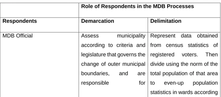
informants in total, two of which were the municipal officials, namely the head of planning and development, the municipal manager, 10 ward councillors, an MDB official, who oversees the KwaZulu-Natal demarcations, and a total of 1 traditional authorities. Tools to obtain this data consisted of interviews, questionnaires, observations and focus groups.
1.9.3.1.1 Interviews
Interviews mirror everyday conversations, although they are rather direct, (to a greater or lesser extent) on the researcher’s needs for data (Cochran et al 2002). This study used semi-structured interviews, made up of closed and open ended questions. This has benefited the study, for data obtained through interviews can be valid, transparent and credible, and not based on a bias perspective. These interviews were conducted with the 2 municipal officials 5 councillors and an MDB representative, simply because of the nature of the study, which poses questions such as their involvement with various stakeholders during ward delimitations and their efforts of resolving the boundary disputes.
1.9.3.1.1.1 MDB Official
The researcher aims to obtain information from an MDB official responsible for KZN demarcation processes. The information should be regarding the consultation process, the level of involvement of various stakeholders, as well as their criteria that governs their demarcation processes. The KZN demarcation representative is most suitable to be interviewed for they have more insight on the processes of demarcation and delimitation of wards as they are involved in them.
1.9.3.1.1.2 Municipal Official
A total of two municipal officials, which comprised of the municipal manager and the head of planning and development, was interviewed because of their involvement in special municipal matters. The information that the researcher aims to obtain form the two officials, is whether or not they are aware of any disputes in their municipality, and what steps and frameworks as a municipality they have put into place to help resolve these
16
existing issues if they are aware of them. Interviewing the manager helped inform their involvement in the matters of the municipality and the community as a whole.
1.9.3.1.1.3 Traditional Authorities
The researcher aimed to interview five tribal authorities on whether or not they are involved in the demarcation, and if they are impacted what implications this has on their jurisdiction. It has been important for the researcher to gain this information as most of the land in the study area falls under communal ownership.
1.9.3.1.2 Observations
Observed data is very useful in overcoming problems between what people say and what they actually do, it helps uncover the behavior of which the observed themselves may not be aware of (Cochran et al, 2002). This tool was used in observing the process of ward delimitation and the consultative process it comes with it.
1.9.3.1.3 Questionnaires
A questionnaire is simply a method of acquiring data by collecting or getting records of information about an issue of interest. It is designed using a list of questions that have instructions, questions and space to answer (Denzin et al 2000). This is one of the tools that has informed the study’s sampling method. Questionnaires were distributed to ward councilors as information pertaining their degree of autonomy and engagement in the process of ward delimitation was very important.
1.9.3.1.4 Focus Groups
Focus groups are participants who voluntarily participate in group discussions that stimulate debates and was used in this study to obtain more natural findings of the problem at hand. This tool was be used when obtaining information from the community
17
members, using ward committee members as informants. This helped stir debates about related issues that are experienced on the ground.
1.9.4 Secondary Data
Secondary data consists of documented literature that has been already collected; this consists of government documents, academic papers, and newspaper articles, books, journals and online material. It also comprises of geographic data and census data. This method worked in favor of the nature of the study and helped enhance and produce more effective findings. The sources, from which the information was obtained, were used to justify and give content to theories, and existing legislative framework, as well as existing developments in relation to the study.
1.10 Data Analysis
The analysis of data was carried out using the thematic data analysis that identifies the themes that have been discussed to summarize the data that has been collected. The data that was analyzed, was obtained from the objectives as well as data and findings collected form the informants, and by using thematic data analysis, the findings were analyzed.
1.11 Limitations of the Study
The limitations that this study has encountered have been firstly; administrative-academic delays where ethical clearance was granted later than anticipated. This issue was dealt with by physically going to administrative offices to seek help and investigate what the delay was. After a few students had physically gone to check for their ethical status, it was then determined that physically collecting your ethical clearance compared to submitting on the day and receiving clearance, as compared to the time frame set by the University for submission. Another limitation that this study has encountered was the engagement with various stakeholders due to their busy schedules. This has set back the
18
study but with stringent goals set for the study to be carried out, they goals and desired objectives seem to have had been achieved regardless of the set back.
1.12 Structure of the dissertation
Chapter 1: Highlights the introduction and background to the study, in the context of local government, the aims and objectives of the study, key research questions, research methodology and the theoretical framework of the study. It also looks at key concepts that inform the study and justifies the importance of the study.
Chapter 2: This chapter focuses on theoretical framework and the literature review, which looked at the evolution of the MDB, the various stakeholders, as well as the policy and legislative framework that governs the study.
Chapter 3: In this chapter, the study area of Ndwedwe Local Municipality, in KwaZulu- Natal is introduced. A historical background was provided as well as the institutional arrangement of the municipality.
Chapter 4: This chapter presents data collected and shows its analysis and interpretation. All the information found in this chapter was based on the findings from the data collected during the study.
Chapter 5: Chapter five provides a summary of findings, conclusion and recommendations which were based on the literature explored and the data obtained.
19
Chapter 2: Theoretical Framework and Literature Review 2.1 Introduction
The theoretical framework provides the context through which this study is designed. It discusses the relevant theories in relevance to their applicability to the nature of the study, making mention of its origins, principles, and their advocacy to the study. The contextual basis of this study was explored through reviewing existing literature and key concepts that form part of the study. In its literature, it looked at both the relevance of existing literature and legislative framework with regards to the nature of stakeholder engagement during the process of boundary demarcation and ward delimitation. Furthermore this chapter provides existing literature regarding the study and case studies relevant to the enquiry of the study.
2.2 Theoretical Framework 2.2.1 The Theory of Territoriality
According to Hensel (1997) territoriality is an approach that is commonly used to studying conflict between disagreements amongst people and over some type of controversial issue (s). Handling these issues also depends on how oppositions decide to handle that sort of conflict, and whether or not they may lead to serious political conflicts that end up involving higher authorities. In as much as many issues may lead to more serious matters, perspectives of territoriality suggest that boundary issues are more noticeable and most likely lead to war because of the value they have within that specific area of jurisdiction (Vasquez, 1999, cited in Hensel, 1997). This is because, most research on controversial issues have had its focus on disputes over territory. In the context of the nature of this study, understanding the theory of territoriality is important, to gain insight of the historic formation of marked boundaries, which can be otherwise viewed as territories marked according to certain criteria.
A territory can be prominent because of the material things it has (Goertz and Diehl, 1992, cited in Hensel, 1997). Territories have been exposed to disputes because they have, and otherwise thought of as having advantageous commodities or resources, that bring value to their land. Other forms of territories are regarded as of value because they
20
provide access to ports or commercial routes. Territory may also be seen as important for its population, particularly when it includes members of an ethnic or religious group that inhabits a neighbouring area. Contextually and most importantly, territories have tangible benefits that contribute to the power dynamics of that certain area as well as the security levels in their regard, and the autonomous state of being that is rooted in that territory (Murphy,1990). In Limpopo the town of Malamulele or the area of Malamulele, both the town (approximately in the center of the area) and area are in the Limpopo province of South Africa has a population that is largely by Tsonga people, and their domination in the province has somewhat led to territorial disputes through the Tsonga peoples dominance.
Territories, which are otherwise expressed in the form of boundaries, realistically on natural ground or through social construction, encourage and discourage connections between community members (Perkmann, 2005). They are hindrances and also theatres of opportunities that entail different availability in service levels and of resources, and have spatial and non-spatial qualities (Paasi, 1999). The theory of territoriality is said to have had been applicable in the northern and eastern parts of Africa, where in Kisanga, a village in Tanzania, boundary disputes, otherwise contextually referred to as territorial disputes, occurred because of land tenure insecurities. McCall (2003) adds that the sources of boundary disputes in Kisanga were due to bad demarcation of boundaries that have ignored existing social boundaries. Although the latter has prevailed, and although demarcation was not clear, most people knew their ownership boundaries very well based on landmarks, more especially the elderly. Delaney and Leitner (1997) on the other hand refer to territories as geographic scales that reflect politics of scale. In their definition of territories, Delaney and Leitner (1997) define territories as “geographic scales which are a nested hierarchy of bounded spaces of differing size, such as a local, regional and natural as well as sub-natural geographic scale”. Literature reveals that regional ‘politics of scale’ originated from Smith (1992), and have for a considerable length of time blended an argument that reflects the suspicion that boundaries are socially arranged with history and are associate with political struggles.
21
Comprehensively, territoriality is a social connection that brings together all persons in a society dependent upon certain standards interfaced on a fixed geographic space (Perkmann, 2005, cited in Anderson, 1999). According to Collinge (1999, cited in Perkman: 2005), territoriality is the way in which spatial political relations are negotiated, where spatial distributions are produced as an outcome, for example in ‘nations’,
‘regions’, and localities. Likewise, ‘territoriality’ is a conceptual benchmark to making and putting into order social relations. However towards a similar occasion, it should be viewed historically, and verifiably evolving (Perkmann, 1999). Territories are confined spaces, and how they relate to each other, both between and within regions, they are prominent for defining the relative positions of various social actors (Perkmann, 1999).
Contextually territories represent politics as a strategic and political action that underlies the evolution of territories (Steinberg, 1994: p.4). It advocates that every visual representation of a border should be expressed as the outcome of social struggles but not intentionally constructed.
Territories are characterized by forms of social representation, with its domination being focused within fixed spaces with various number or group of people (Perkmann 1999).
The premise of territories is that they function as places of governance, where institutional organizations generate effects that are favorable to certain social vigor on different scales (Ray, 1998). In turn, they provide institutionalized power as a foundation for social actors for whom (the control of) territory becomes a concrete benefit to them. From such a perspective, the issue of the extent of boundaries and their redetermination is very prevalent, because geographic boundaries and the institutional functions that govern them change the social and productive bases of boundaries and also change the resource position boundaries have an impact the community as a whole (Perkman, 1999). It is clear that the processes of re-determination and delimitation of boundaries has therefore led to social controversy as they can be expected to significantly affect power, resource allocation and life chances of social groups organized at different levels (Perkmann, 2005).
Territorial development cannot be done away with and remains an ongoing construction in the hands of local actors and stakeholders. Appropriate public policies may be used to
22
stimulate the latter over time, but it still lies in the responsibility of the local, for its principle is based on asset identification that differentiates between territories. A comprehensive understanding of territories (territorial development) and their social construction will benefit the study in terms of addressing certain issues faced in local spheres of governance. Ray (1998) has referred to territories as places of governance and that therefore relates to wards significantly as they provide institutionalized power that allows social actors whom the control of the territory becomes a concrete benefit to them. This study will apply this theoretical perspective in analyzing data obtained from participants.
The theory of territoriality is also very significant to this study because of the inherent loyalty and attachment be it social, cultural, or economic benefits people have put in to belonging to that specific territory.
2.2.2 Collaborative Planning
‘Every time we stop and consider what options to take before making a choice we make a plan. We imagine what might happen and the consequences that could ensue and judge these effects in relation to our capacity to choose and act’ (Hoch, 1994). Although planning can be carried out in a number of ways, collaborating ideas diversifies and compromises preferences and expected outcomes. Collaborative planning is when power is widely diffused, and based on consensus that ensures reasoned discussions about a subject matter (Margerum, 2002). Collaborative planning makes planning an interactive process in order to capture widely shared social meaning. It involves interactions in the form of a partnership through consensus building, developmental planning and implementation. Given the transformation from apartheid planning in South Africa, many planning efforts have been made primarily geared towards integrated development, with the premise of inclusion, and ensuring that the level at which development and service delivery takes place, which is the local level, is being involved in the development of their communities. It offers with it, the utility in understanding shared views and the level of influence they have in developing consensus, and more particularly and contextually in support of the premise of ‘planning with and planning for the people’.
23
Keating (1997) finds it ironic that spatial disputes have led to new forms of politics that have been focused primarily on territoriality and new relationships between it and social, political and economic change. Although much of this ‘new politics’ is around the competitive pursuit of growth and power, Keating (1997) identified that a collaborative model of planning for development in localities and regions not only competes, but should collaborate in pursuing objectives of common interest, and negotiate matters of potential interest. Therefore collaborative planning is one of the theories in which this study encourages given the identified problem of the level of engagement with various stakeholders, and applying the theory of collaborative planning is seen as a necessity.
Collaborative planning is an important planning theory, related to the networking of society, by creating institutions that are regarded as inclusive environments that allow for deliberation among the private and public sector stakeholders (Agger and Lofgren, 2008, cited in Healy, 2003).
Although the theoretical framework of collaborative theory resonates a democratic effect its processes are often overlooked in reality. The initial idea for Collaborative Planning was formulated in the mid-1980s, and documented in a book by Pasty Healy (2003). The theory of Collaborative planning came about as a tool of decree of the implementation of plans into built form, towards an inclusive approach aimed at shaping social spaces, which appeared to have features of contemporary society (Healy,2003). Healy (2003) alludes to some of the principle’s that guide collaborative planning, saying that;
collaborative planning was driven by the idea that planning is an interactive process;
secondly with the premise that planning is driven by ensuring good governance occurring in complex wide governmental environments, characterized by wider economic, social and environmental forces that shape, but do not determine, specific interactions; thirdly, planning and policy initiatives concerned with maintaining and enhancing the qualities of places and territories; and finally, motivated by a commitment to social justice, especially as realized in the experiences of daily life as well as in the context of culturally diverse values about local environments and ways of life. Healy’s (2003) interpretation of collaborative planning was based on the assessment of top-down policies that were implemented in the UK and used those experiences that ignored the local’s views and
24
interpretations of developmental projects as a tool to carry out the inclusive process of collaborating planning projects.
According to Healy (2003) good governance is an element in which societies and social groups, manage their collective affairs. Good governance can occur and be perceived by people differently, however contextually good governance can also occur through collaborative planning where its automatically regarded as a process of public policy- making and as such part of the democratic governance of a certain territory. Within the current theoretical debate on collaborative planning, many of the arguments in favour of using collaborative thinking as a prelude of going beyond the basic idea of collaborative planning, that is, negotiating between conflicting social interests, and creating similar ideas of the future of a particular geographical area (Healey, 2003). Consequently, since collaborative planning activities have become institutionalized policy-making processes across many democratic systems, they should also be subject to democratic scrutiny in line with other political institutions and processes in society.
The purpose of this study is to expose the theory of collaborative planning to the reality of planning, by assessing its importance for informing and explaining what planners
‘really’ do and can do. By carrying out this systematic appraisal of collaborative planning, this study uses this theory as an assessment of stakeholder engagement, during the process of boundary demarcation and ward delimitation ward delimitation, in the hope of finding out how applicable it is during the process in the latter.
2.2.3 The Inclusionary Theory
“Regional development is a broad term but can be seen as a general effort to reduce regional supporting economic activities in regions (Allen et al, 2003)”. The concept of regions is widely used both in terms of policy and practice but also in common usage.
However because of its broad nature, it encompasses an umbrella of theories that help explain its nature. Firstly, defining any of the theories that fall under regional development must be addressed in correlation of what a region is, and through which context the definition of that region is being addressed.
25
A region can be defined using a wide range of criteria, but common criteria includes spatial or geographical variables (McCall, 2003). Regions are defined as areas of physical space that is demarcated for some particular reason ranging from administrative, planning or statistical analysis, and is usually large in scale, than a single municipal area (OECD, 2015). The demarcation of regions is usually made to correspond with some natural or economic system or with the perceived space of cultural space. Regions can vary in physical size, population size of economic strength and there are often hierarchies of regions that range from provinces, districts and sub-regions (McCall, 2003). Given the definitions outlined of what a region is, it therefore becomes imperative to consider the efforts of planning put towards regional development, given the wide spectrum some regions cover, as well as the need for other theories, existing under regional development that contextually address matters of demarcation and territorial disputes.
Regional planning does not ask about the extent of the area, but how the population and civic facilities can be distributed as to promote and stimulate sustainability throughout a whole region (Tigere, 1998). One of the ways in which the latter can be addressed, is through inclusionary, for often development projects tend to leave out important stakeholders in development projects and local government matters. Differentiating between regions is a lengthy process, which can also be determined by how stable that certain region is. Bearing the latter into consideration assists the recording and observation of socioeconomic reality on a regional or local scale for future planning.
Development scholars have widely explored regions, and in so doing, Allen et al, 1998, emphasizes that regions are not confined spaces but rather a series of open and discontinuous spaces that can be made up by social relationships that stretch across areas in ways that depend on how a region has been defined.
In essence, what shapes these regions are their determining boundaries, as scholars classify boundaries into physical, geometrical, disputes over sovereignty, which have overtime become more prominent as living conditions in regions are highly influenced by new technologies growth trends and the extension of new settlements into areas that were once largely unpopulated. Taking into cognizance the latter regions are contextually spheres in which the politics of engagement are often articulated and the platform
26
whereby political power is being contested. Regions and regional policies have then appeared to be politically contingent as ‘the adoption of regional policies and their specific nature can only be understood by analyzing how the conflicting interests of various social groups within a country are mediated through the institutional apparatus of state (Allen et al, 1998)
Given the factors that are inclusive of what constitutes a boundary, it then becomes of vital importance to acknowledge various stakeholders in the configuration of boundaries.
Opinions have increasingly favoured the use of deliberative and inclusionary processes so as to aid the decision making of public affairs. This then helps ‘democratize democracy’
as means of encouraging civic engagement and making the work of public governance more responsive and legitimate (Bloomfield, 2001). By using the inclusion theory this study, aids the context of the study, given its problem statement, with the assumption that there is lack of inclusivity during the process of demarcation of municipal boundaries and delimitation of ward boundaries. This theory assists the study, primarily because of the vested principles of inclusivity, as it focuses on enabling all people to participate actively in social, political, cultural and economic life within their community. It further aims at adapting existing systems and structures to the diversity of human needs. Thus, social inclusion has the potential to combat poverty and exclusion while at the same time fostering development (Bon, 2013).
2.3 Literature Review
2.3.1 The Importance of Municipal Wards
In South Africa, wards are geographic subdivisions for amongst others, electoral purposes. Each metropolitan and local municipality is delimited by the Municipal Demarcation Board into half as many wards as there are seats on the municipal council (rounding up if there are an odd number of seats). Each ward then elects one councillor directly, and the remaining councillors are then referred to as party representative officers, whom are elected from, for balance purposes in parties voted for (www.demarcation.org.za, 2015). According to Sibiya (2011), municipal wards are divisions of local government that deepen local governance and are the building blocks of ensuring good governance, translating directly what the community aspires. The