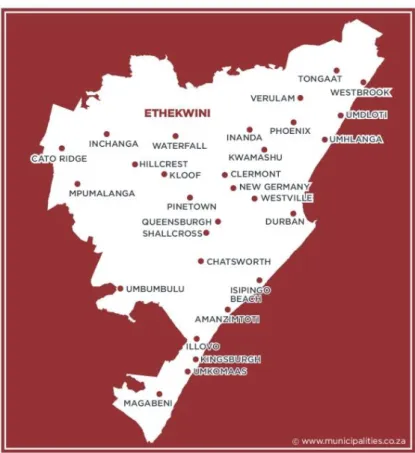
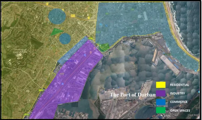
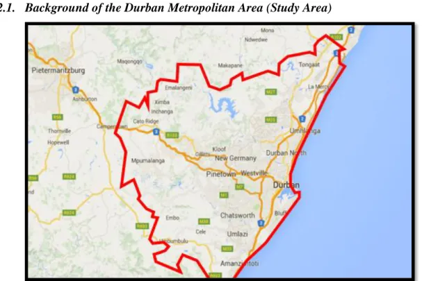
The history of the Durban Metropolitan Area (DMA) is embedded in the creation of the Port of Durban, which is located on the coastline stretching from Umkhomaas (south of Durban) to the Ballito area (northern areas). These spatial adjustments have seen the decentralization of business from the Durban Central Business District to the Durban North areas.
INTRODUCTION
- Introduction of chapter
- Introduction of study area
- Background of the Durban Metropolitan Area (Study Area)
- Background of the three Theoretical Growth Models used in the study
- Problem Statement
- Research Question
- Hypothesis
- Objectives
- Subsidiary questions
- Rationale
- Chapter Outline
- Conclusion
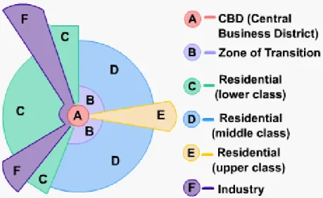
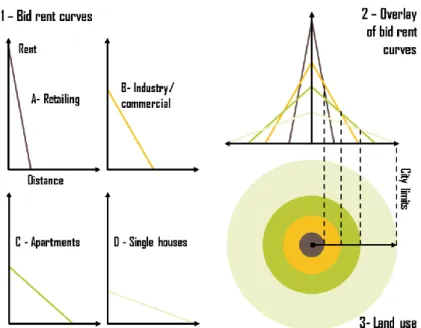
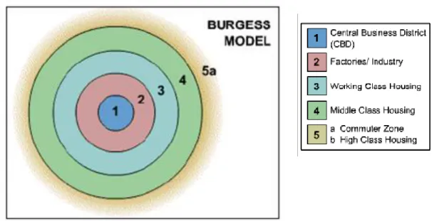
To determine the spatial limitations of the Burgess concentric zone theory, the Hoyt sectoral theory and bid rent theory in the post-apartheid Durban Metropolitan Area;. What are the spatial limitations of the Burgess concentric zone theory, the Hoyt sectoral theory and bid rent theory in the post-apartheid Durban Metropolitan Area.
RESEARCH METHODOLOGY
- Introduction
- Data Collection
- Secondary Sources
- Primary Sources
- Data Analysis
- Limitations of the Study
- Recommendation’s in improving the study
- Conclusion
One-to-one interviews were conducted with various stakeholders involved in the development of the NCBD. Another limitation within the collection of data was the availability of the key informants from the various institutions.
LITERATURE REVIEW
Introduction
Theoretical and Conceptual Framework
- Theories of Urban Development
- Globalization
- Urbanization
- Migration
- Multiculturalism
- Monocentric and Polycentric
Durban North is an example of the concept presented by Greed (1996) in the sense that it evidences the displacement of land uses from the Urban Core as a result of commercial industry moving north (Green, 1996). This led to the creation of the Garden City movement in Cape Town (Mabin and Smit, 1997).
Precedence and Literature Review
- International Experience of a Developed Country
- International Experience of a Developing Country
- National Experience of Polycentric Developments and Land Use Planning . 42
David's shopping center in Cardiff city centre, which was part of the regeneration project in the city. Economic decline (when large commercial businesses moved from the city center to the outskirts. These characteristics contributed to the sensitivity of the area to the society living within it (Ofosu-Kwakye, 2009).
This waterfront would extend further into the area, contributing to the economic benefits of the city center (Sher, 2009).
Conclusion
Although the renovation of the Point Waterfront area and the adjacent land uses appears to be one of the essential solutions to ensure the success of this project, this radical solution has proven to be very expensive and requires intensified and strengthened relationships and restructuring of the efforts of both private developers and city management. Furthermore, this particular development is still lacking in research as to how it can be accelerated to enable rejuvenation and redevelopment of the greater urban area. Furthermore, various policies and urban management regulations should be introduced to encourage people of all classes to reside in this area, such as standardizing rents, reducing property prices, and developing units with lower square footage to enable affordability and thus avoid marginalization of low - for the middle class.
FINDINGS AND DATA ANALYSIS
Introduction
Background and Demographics of the Durban Metropolitan Area
- Population
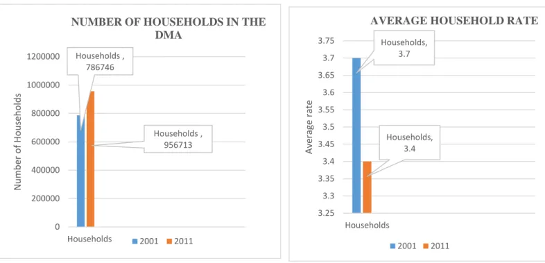
- Number of households
- Formal dwellings
This highlights the extent to which development is accompanied by housing development to accommodate the growing population. This shows that there is an increase in the formalization of households in the DMA. 85% of the land in the DMA is categorized as urban land, with 14% of the total land being tribal land.
This underlines the speed at which urbanization is outpacing itself in areas like the DMA.
Physical Spatial Adjustments of various elements in and between the Durban
- Physical Spatial Adjustments of the Durban Business Area
- Physical Spatial adjustments of the Durban North area
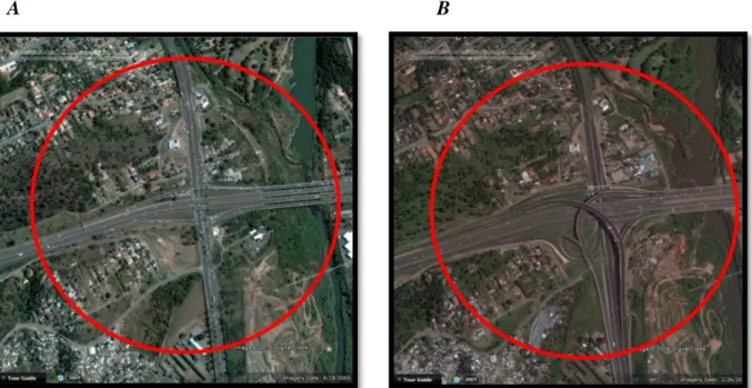
The M41 branches off from the Durban N2 road leading to the Umhlanga Ridge areas (Figure 4.10A). The high income gated development is located in a neighborhood accessed from Herrwood Drive on Umhlanga Ridge (Figure 4.12A). The close proximity of the business area to the M14 Motorway (Figure 4.14A), which connects to the center of Durban, has created a strong interest from business owners in locating land at high connection points – which helps with convenient delivery of supplies.
Figure(s) 4.14: Developments that occurred in the period between A - 2005 and B - 2016 around the road connecting the Umhlanga business and office area with the M14 motorway to the Durban CBD.
Inadequacies of past spatial models and pressures to respond to socio-economic
- Urbanisation
After 1994, with the fall of the restrictive apartheid laws, there was a general shift in the development of the DMA. However, the spatial design of the CBD area limits the ability of the CBD area to expand. The DMA's growing population has also contributed to the need for space to accommodate the growing numbers.
The DMA has thus seen a development towards the northern and western regions of the metro, where there are large plots of vacant land.
EThekwini Municipality’s Development Mandate
- Planning policy guiding developments in the DMA post-1994
- Land use planning in EThekwini Municipality
- Changes in land use plans between 2012- 2017
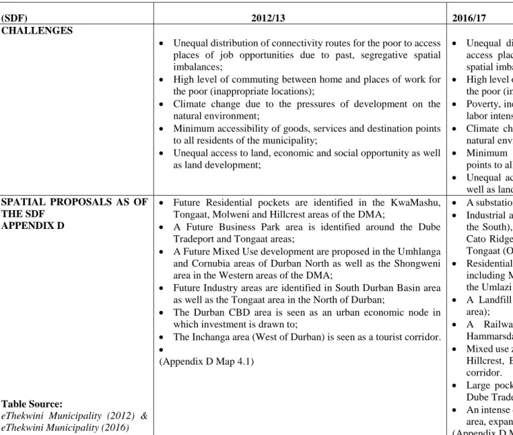
According to a respondent from THD, the eThekwini Municipality - which uses various areas, development plans and policies - leads and controls the development of the Durban North areas. Minimum accessibility of goods, services and destination points for all residents of the municipality; and. Future residential pockets are identified in the KwaMashu, Tongaat, Molweni and Hillcrest areas of the DMA;.
A future Mixed Use development is proposed in the Umhlanga and Cornubia areas of Durban North as well as the Shongweni area in the Western areas of the DMA;.
Umhlanga as a New Town Area
- The impacts of the availability of vacant land in the North
- Business Investment as a development tool
- Convenience to amenities in Umhlanga
- Managed areas as a new preference
Umhlanga Rocks is currently characterized as an advanced business area and respondent one from the eThekwini Municipality mentioned that "the area has contributed significantly to the economic development of the city of Durban." The area encourages convenience for both those who live in the area as well as those who visit the area. In and around the Umhlanga area, various means of public safety are in place to ensure that the area is safe for those who use it,” said respondent three.
Respondent two from THD said the sites used to develop the Umhlanga area include designs that ensure the area is “aesthetically pleasing to the eye”.
The Aerotropolis as a future New Town Area
These departments aim to boost the economy of the DMA by providing industrial and commercial opportunities that have attracted investment (DTPC, 2013). In addition, the establishment of Dube City (Figure 4.6) has expanded the residential, office, retail and leisure (hotel) DMA and is connected to the Durban CBD via an improved road network (N2 and R102) connecting the northern and southern parts of Durban (DTPC, 2013). . The Dube iConnect area has increased the technological base of the DMA to bring it closer to the concept of intelligent cities.
The Dube Agrizone plan/precinct was developed to increase Durban's industrial and commercial sector through the development of agrilabs, nurseries and greenhouses, contributing to the economic condition of the DMA (DTPC, 2013).
The new model of development
- New Town Centres as the future of South African cities
- New Urbanism as a development concept
- Positive impacts of the North Developments on the DMA
- Negative impacts of the North Developments on the DMA
The pressure on development has therefore shifted a development to areas in the North and West regions of the DMA,” said Respondent two of THD. Image(s) 4.7: The Umhlanga area with vegetation (A) and mixed use (B) as part of the design plan. Respondent one from eThekwini Municipality added, "There is also a tremendous response to the economic viability of the developments in the North".
The development of the Durban North areas saw numerous activities and intense development points for the city of Durban.
The planned developments for the further expansion of the Durban
- Urban regeneration as a reconstructive development tool for the CBD
- The development of the Western region (Shongweni)
- The development of Integrated Human Settlements
Respondent three from THD mentioned, "Tongaat Hulett Development (THD) owns some of the land in Shongweni, which since the Moreland Report in 2002, has been seen as a possible development node for the Outerwest DMA". The development of the Shongweni area will be very similar to that of the Umhlanga area. The development is expected to take a similar direction to the Umhlanga developments, but "within the unique context and needs of the area" Respondent one continued.
In response to the spatial and social fragmentations of the past, a pilot project in Cornubia is currently underway to encourage the development of multiple income/household groups in one area”, said Respondent two from eThekwini Municipality.
Conclusion
The concept of creating a new city center through the establishment of a shopping center acts as a development catalyst,” said respondent from THD. This development will ensure a balance in the pace of DMA development,” said respondent two from THD. Twenty-two years after democracy, housing needs have shifted from the need for physical structures to the need for integrated human settlements.
Respondent two from THD added: “This land is also part of Tongaat Hulett Holdings and is being used to ensure that low-income earners are not excluded from high-quality developments in the North.”
RECCOMENDATIONS AND CONCLUSIONS
Introduction
Major Findings of Objectives
The Durban North Precinct represents the DMA's Spatial Development Framework plans as an economic corridor from the city of Durban. These plans are used in the Durban Metropolitan Area to ensure that development is relevant to the challenges of the metropolitan region. These are some of the drivers for business investment in Durban's CBD area.
What factors of the Durban North area are driving mushroom developments in this area. What land uses have been identified as sparking/necessary in the development of the DMA. How has the growth of the Durban North area affected the Durban city center (negatively and positively).
Final Conclusion
Cele, BP (2010) An assessment of people's perceptions of the sustainability of Cato Manor's local economic development initiatives in post-Apartheid South Africa, University of KwaZulu-Natal, South Africa. Cilliers, E.J and Schoeman, C.B (2008) The Urban Development Boundary as a Planning Tool for Sustainable Urban Form, Vol 117, WIT Transactions on Ecology and the Environment, South Africa. Davidoff, P (1965) Advocacy Planning and Pluralism in Planning in Campbell, S and S Feinstein (1996) Readings in Planning Theory, Blackwell, Oxford. 1963) The Growth of the Durban Metropolitan Area, South African Geographical Journal, South Africa.
Rushby, J (2001) An Analysis of International Trends in City Center Restructuring and Office Decentralization in Durban, University of Natal, South Africa.
APPENDICES
What are the benefits of development in the Durban North Area, as opposed to the Durban CBD? Do you see the Durban North Area as a continuation of the Durban CBD or as a new CBD in its own right? After 1994, the Durban Metropolitan Area (DMA) has seen several changes in growth patterns accompanied by a variety of needs – which are the necessary enablers – in modern developments.
The research will therefore be used to collect data around the subject, including policy, development prospects and factors that result in the various developments in the north of the Durban Metropolitan Area.
Durban’s Inner city region
Dilapidated building in Durban CBD
Cribbs Causeway mall (Britain)
Cribbs Causeway Parking (Britain)
St. David’s Shopping Mall (Britain)
Johannesburg in the 1960’s
Braamfontein in the 1960’s
Physical adjustments in William Nicol (Sandton)
The Port of Durban
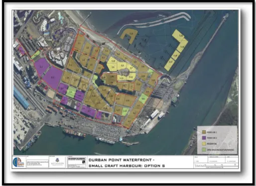
Vacant buildings in Durban Point Waterfront
Wasted space in Durban Point Waterfront
Aesthetics of Durban Point Waterfront Area
Scenery Design of Durban Point Waterfront Area
Mixed use in Durban Point Waterfront Area
Design Elements in Durban Point Waterfront Area
Landscape Design in Durban Point Waterfront
Parking and Delivery Zones in Umhlanga
Mixed Spaces in Umhlanga
Surveillance in Umhlanga
The King Shaka International Airport
Dube Tradeport Cargo Terminals
Dube Tradeport Dubecity
Greenery in Umhlanga
Mixed Use developments in Umhlanga
Dilapidated Buildings in Durban CBD