The effect of groundwater was clearly visible, as the soil during the rock overflow showed a higher amount of soil water compared to the sandy loam soil throughout the production season. Taking DUL and LL into account, the state of water content in the soil throughout the production season was assessed for each of the soil forms.
INTRODUCTION
Background and Problem Statement
Research indicates that there is a correlation between the amount of soil water and the quality and yield of cotton. This has shifted the focus to soil water management, specifically the effect of soil type on the amount of soil water.
Hypothesis
One of the areas of uncertainty for producers in the dryland cotton industry is soil water management. The presence and depth of a soil water layer has been identified as a major factor affecting cotton yield and quality in dryland production (Che et al., 2021; Mohamedin et al., 2010).
Aims and Objectives
LITERATURE REVIEW
- Cotton Production
- Cotton Morphology
- Cotton Root System
- Cotton Growth Stages
- Emergence
- Flowering
- Boll Formation and Burst
- Cotton Quality
- Cotton Quality Determination
- Cotton Quality Properties
- Soil Water
- Neutron Scattering
- Neutron Probe Calibration
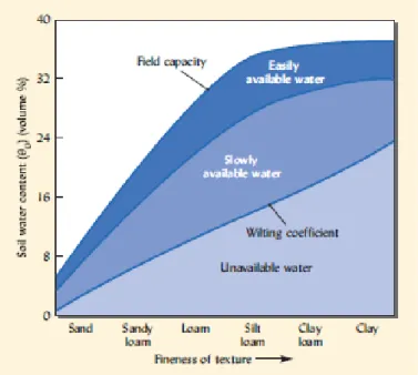
- Soil Water Characteristic Properties
- Drained Upper Limit
- Lower Limit
- Plant Available Water
- Soil Water Studies
- Cotton Growth and Soil Water
- Influence of Water Stress on Seed Cotton Yield and Quality
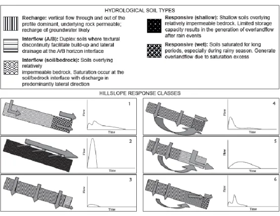
- Hydropedological Classification of South African Soils
- Hydropedological Soil Types
- Internal Drainage of Soils
- Statistical Analysis
- One-Way ANOVA in R
Different states of soil moisture content occur: saturated, drained upper limit and lower limit. 2012) conducted a two-season study of groundwater shortage in an irrigated cotton field.
STUDY AREA
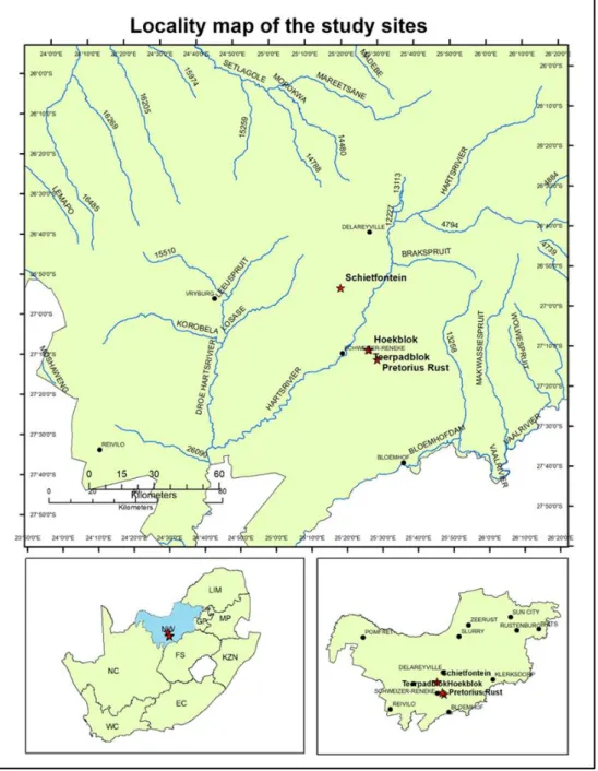
- Locality of the Study Area
- Agronomic Practices
- Regional Soil Description
- Geology
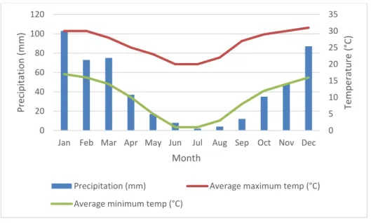
- Climate
The geology of the Teerpadblok, Hoekblok and Pretorius Rust fields are part of the Karoo Super group (CGS, 2015). The subsurface geology covering the aforementioned fields is consistent with that of the Ecca Subgroup.
MATERIALS AND METHODS
- Determining the Measuring Sites in Each Field
- Installation of the Access Tubes
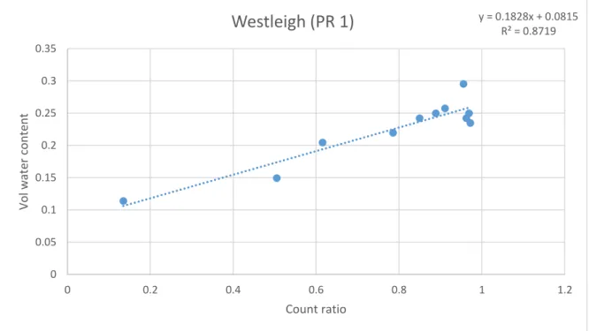
- Calibration of the Neutron Probe
- Measurement of the Soil Water Content
- Determination of the Soil Water Regime
- Undisturbed Core Sampling
- Pressure Plate Extraction
- Cotton Yield and Quality
- Seed Cotton Yield
- Cotton Quality
- Data Analysis
The gravimetric soil water content was then converted to a volumetric water content using the dry bulk density of the sample horizons and the density of water. During each day of groundwater measurements, a standard neutron probe count was obtained.
RESULTS AND DISCUSSION
Season 1 Results and Discussion
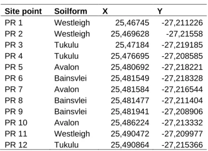
- Pretorius Rust Measurement Sites
- Diagnostic Soil Horizon Descriptions of Pretorius Rust
- Orthic Topsoil horizon
- Yellow-Brown Apedal Subsoil Horizon
- Red Apedal Subsoil Horizon
- Neocutanic Subsoil Horizon
- Soft Plinthic Subsoil Horizon
- Gleyic Subsoil Horizon
- Pretorius Rust Soil Properties Description
- Schietfontein Measurement Sites
- Diagnostic Soil Horizons Description of Schietfontein
- Hard Plinthic Subsoil Horizon
- Schietfontein Soil Properties Description
- Calibration of the Neutron Probe
- Pretorius Rust
- Schietfontein
- Soil Water
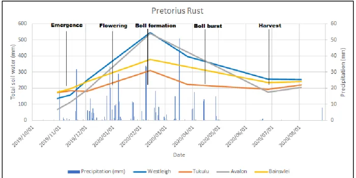
- Pretorius Rust Total Soil Water
- Schietfontein Total Soil Water
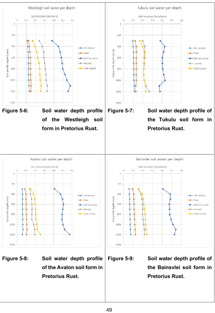
- Pretorius Rust Soil Water Depth Profiles
- Schietfontein Soil Water Depth Profiles
- Season 1 Soil Water Characteristics
- Pretorius Rust Soil Water Regime
- Schietfontein Soil Water Regime
- Cotton Yield and Quality
- Pretorius Rust Seed Cotton Yield
- Schietfontein Cotton Yield
- Pretorius Rust Cotton Quality
- Schietfontein Cotton Quality
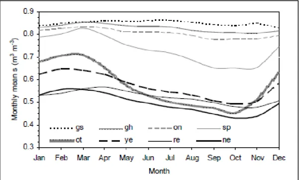
As time progressed, the Westleigh and Avalon landform increased exponentially in soil water content. The Bainsvlei soil form is naturally in a reduced state, which means that the water content of the soil remains constant. Due to the physical nature of the Tukulu soil horizon, it tends to retain ground water.
Soil water content above DUL is observed very early in the cotton growth process. Soil water content above DUL is reached very early in the cotton growth process. Soil water conditions above the DUL are reached very early in the cotton growth process.
Season 1 Conclusions
- Pretorius Rust
- Schietfontein
- Combined Conclusion
When comparing the two soils that were above DUL during flowering and bulb formation, when the cotton is most sensitive to water stress, it is inevitable that the cotton prefers the more oxidized environment in the substrate in the form of apedal horizons on the plinth horizons. All soil forms identified in the Schietfontein field are classified as sandy-clay-loam soils in terms of texture. The Oakleaf and Tukulu soil forms had the highest percentage of clay in the topsoil and subsurface horizons.
All landforms in Schietfontein have a red color in the subsoil horizon to indicate water flow from the soil profile with the sole exception of the Tukulu landform. In the lower part of the soil profile, the amount of soil water remained the same. Comparing soils that were above DUL during flowering and boll formation, when cotton is most sensitive to water conditions, it is inevitable that cotton prefers a more oxidized environment in the subsoil in the form of apedal horizons over solicized horizons.
Soils that have a gray-colored gleic soil horizon in the matrix tend not to decrease in soil water content after the season compared to bounding plintic layer horizons. However, there has been a change in the amount of soil water that a soil can hold against gravity (DUL), which then explains the variation in soil water content throughout the growing season. Soil water content was observed to be above the upper drained limit during critical growth stages (flowering and boll formation), which may have caused water stress in cotton through anoxic conditions.
Season 2 Results and Discussion
- Hoekblok Measurement Sites
- Diagnostic Soil Horizon Description of the Hoekblok
- Pedocutanic Subsoil Horizon
- Hoekblok Soil Properties Description
- Teerpadblok Measurement Sites
- Diagnostic Soil Horizon Description of the Teerpadblok
- Teerpadblok Soil Properties Description
- Calibration of the Neutron Probe
- Hoekblok
- Teerpadblok
- Soil water
- Hoekblok soil water
- Teerpadblok Total Soil Water
- Hoekblok Soil Water Depth Profiles
- Teerpadblok Soil Water Depth Profiles
- Season 2 Soil Water Characteristics
- Hoekblok Soil Water Regime
- Teerpadblok Soil Water Regime
- Cotton Yield and Quality
- Hoekblok Cotton Yield
- Teerpadblok cotton yield
- Hoekblok Cotton Quality
- Teerpadblok Cotton Quality
This is due to the downward flow of soil water deeper into the soil profile. In the period between bread formation and bread bursting, soil water content became constant until harvest. In the period from the beginning of the shaft explosion to the harvest, the water content of the soil increased slightly.
In the period from the beginning of the formation of buns to bun bursting, the soil water decreased slightly.
Season 2 Conclusions
- Hoekblok
- Teerpadblok
- Combined Conclusions
All other soil forms belong to group O, which is the second best quality group. Bloemdal, Sepane and Westleigh soils with accumulation at the base of 200-300 mm soil profiles, as all soil forms in Hoekblok show typical characteristics of groundwater soils. The water content of the soil, which was above the DUL, was much lower than in the sandy clay soil of the previous season.
The Westleigh soil type has the lowest clay content of all the soils but has the highest soil water content throughout the growing season. The soil water content of the Westleigh soil form was well above DUL throughout the season, which can lead to soil water conditions above DUL that can cause water stress in cotton. Soil water content had significant differences depending on the physical characteristics of the landforms.
It was evident that in a field where similar soil properties occur in different soil forms, the soil water content remained the same. Differences in textural properties result in different soil water contents throughout the growing season. Water accumulation occurred in the lower 200–300 mm of the soil profile after the season, indicating the occurrence of groundwater in the fields.
Season 1 and 2 Conclusions
CONCLUSION AND RECOMMENDATIONS
Season 1 Conclusions
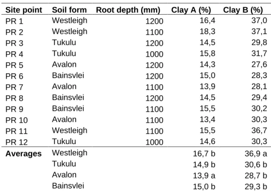
It was evident that the Westleigh soil form with the highest clay content in the A and B horizons had the highest soil water content throughout the season. The Avalon landform had the lowest clay content in the A and B horizons, but had similar soil water content to the Westleigh landform, illustrating the groundwater characteristics of the landform. Soil water conditions above the DUL were found in all soil forms due to high seasonal rainfall.
Soil water conditions above the DUL tend to have a negative impact on yield in areas consisting of sandy loam soils as the lowest yield was produced by these soils (2.93 tonnes/ha – Tukulu) due to the ability of the conditions anoxic to it. limit cotton to produce more bolls to result in higher yield (Ninari et al., 2004). Soil water conditions above DUL tended to benefit sandy loam soils as these soils recovered well due to good internal drainage in the subsoil horizons and produced the highest yield (3.96 tonnes/ha - Avalon). With little difference in the physical properties of the soils, the Oakleaf and Tukulu soils had the highest clay content in the horizon and as a result had the highest soil water content throughout the season.
Bottom water conditions above DUL were observed in the Oakleaf, Glencoe, and Tukulu bottom forms. Groundwater conditions above DUL are generally favorable for the Oakleaf soil form, as this soil produced the highest yield (2.61 tons/ha). The groundwater conditions above DUL on the Tukulu soil form had a negative effect because the lowest yield (2.37 ton/ha) was produced on these soils.
Season 2 Conclusions
Final Conclusions
Soil water content varies between different soil forms and this is mainly due to differences in clay content in the A and B horizons and in root depth. The sandy-clay soils tend to be above the DUL for extended periods, compared to the sandy-clay-loam soils, which tend to be above the DUL for only a short period due to good internal drainage. Since texture affects soil water content, the water regime is different for each soil form.
There was a clear depth difference between the four locations, which influences the groundwater content and the behavior of the soil forms. Shallower soil profiles do not stay above DUL for long periods of time and tend to dry out compared to the deeper soil profiles. The amount of water available to the plant was different between different soil forms, and as such the yield is related to the groundwater being more readily available throughout the production season.
It is observed with the Tar Pad Block field that the higher the clay content in the A and B horizons, the higher the yield. Groundwater conditions above DUL on sandy clay soils tend to produce better quality cotton compared to groundwater conditions above DUL on sandy clay loam soils which tend to produce lower quality cotton. The higher the clay content, the higher the micronaire of the fiber visible in the sandy clay soil.
Recommendations
An analysis of industrial and domestic wastewater in South Africa as a water-scarce country, International Journal of Applied Engineering Research. Effects of soil water content on growth and root distribution of cotton under drip irrigation with mulch. Temporal stability of soil water supplies measured with a neutron probe and the effects of calibration procedures in a small watershed.
Estimating groundwater content using site-specific calibration of Sentek Enviroscan Systems capacitance measurements. Relationships between planting and soil water status in five field grown cotton (Gossypium hirsutum L./cultivars). Impact of rainfall variability on maize yield in KwaZulu-Natal, North West and Free State provinces of South Africa.
Effect of water regime and runoff strip width on soil water balance for an integrated field rainwater harvesting. Negative role of soil salinity and waterlogging on crop productivity in the northeastern Nile Delta region, Egypt. Coupling DSSAT and HYDRUS-1D for simulations of soil water dynamics in the soil-plant-atmosphere system.
The relationship between soil morphology and soil water regime: preliminary results in the Weatherley catchment.