The research argues that Albert Park presents a microcosm of the key planning and development challenges in inner-city neighborhoods in South Africa and other international cities. Methembe and Khanyi, you have always reminded me of the most important things in this life.
Brief Motivation and Background
In the years that followed, the urbanization of Sao Paulo increased further due to the constant internationalization of the economy. The growing industrialization of the city of Sao Paulo and other cities in Brazil led to rapid urbanization as job opportunities attracted more immigrants to the city.
Problem Statement
The Case Study Focus
It can be said that the current poor aesthetic appeal of the area also contributes to the negative perspective that Albert Park presents. The program has seen some of the buildings within Albert Park undergo renovations and be used for social housing.
The Main Research Objective
The Sub-Objectives
The program is guided by six targeted outcomes, namely, increasing economic activity, reducing poverty and social exclusion, making the inner city more viable, effective and sustainable urban management, improving safety and security as well as development of institutional capacity (Ethekwini Municipality, 2011). However, having said that, and still considering the current trail of decay within Albert Park, one would question the effectiveness of iTrump.
The Main Research Question
The Sub-Questions
The Hypothesis
The Structure of the Dissertation
As such he conceptualizes neighborhoods and neighborhood design and management as key research concepts. In the fourth chapter entitled 'Precedence Studies', the experiences of different cities and inner-city neighborhoods around the world are assessed to establish the link between design and management and to learn from the successes and failures of those that may have experienced or are currently. experiencing the same or similar scenarios as Albert Park.
Concluding Comments
The aim is to be able to assess the role that design and management have played in the transformation of Albert Park from the past to the present, as well as the possible role it may play in the near future. The final chapter provides a conclusion to the research and links all the data presented to the original purpose of the research, as well as providing a possible contextual inner city neighborhood design and management criteria or guidelines for the regeneration of Albert Park.
Introduction
The Neighbourhood defined
The Neighbourhood as a System in Itself
All this allows the residents of the neighborhood to meet face to face while going about their daily activities. The successful functioning of the neighborhood depends on how well its various components work together.
The Identity of the Neighbourhood
The physical identity or physical composition of the neighborhood is also related to the social aspect. All these issues have an effect on the physical environment and in turn the development and identity of the neighborhood and its residents (Jacobs, 1961).
The Neighbourhood as a Component of the City
Development within a neighborhood can be the physical development of the neighborhood in terms of available facilities, but also the development of people in terms of their self-worth, their literacy and well-being, their identification with the neighborhood and relationships within the area. The neighborhood concept is both a planning tool in the city and a functional planning framework.
Defining Neighbourhood Design and Theories that Underpin it
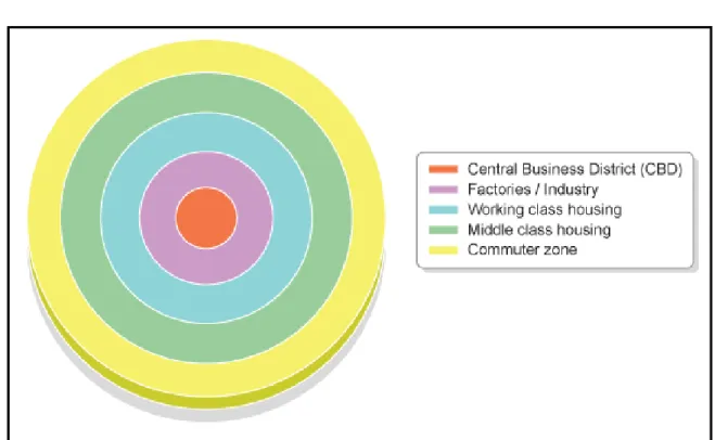
The Neighbourhood Concept
This will both limit through traffic in the neighborhood and limit fast travel in the neighborhood. Perry believed that schools and other institutional services should be centrally located in the neighborhood to ensure accessibility for all residents without the use of the motor vehicle (Walters, 2007).
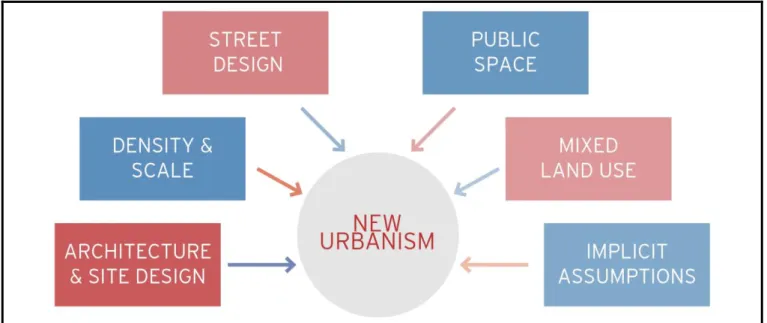
New Urbanism
One of the ways that New Urbanists strive to improve a sense of community in neighborhoods is by stimulating more social interaction between residents. The belief is that new forms of design can be implemented in a way that encourages residents to leave their homes to spend more time in the public realm on the streets, parks or other public spaces.
Sustainable Urbanism
Sustainable neighborhoods are those that encourage high density because of the many benefits it brings to the neighborhood. Higher densities that promote sustainable urbanism are achieved by offering different types of housing in the neighborhood.
Neighbourhood Management
Coordination of specific services coming to the neighborhood (coordination of inputs to maximize benefits and minimize waste) this includes housing, health facilities, education, police, leisure facilities and possibly regeneration initiatives;. One way of looking at neighborhood management would be that it forms a better link between the neighborhood and local government.
Inner-city Neighbourhoods
Therefore, it is important to consider these differences when planning urban neighborhoods. The demographic composition of local residents also affects community life in the neighborhood.
Conclusion
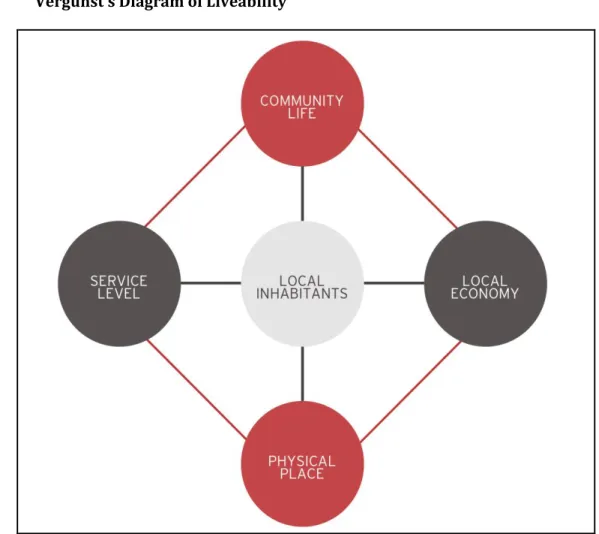
The final consideration is that of the local economy, which refers to the ability of an area to generate income and employment (Leby and Hashim. 2010). Mixed-use developments allow a greater variety of economic services to be available in a neighborhood, resulting in an increase in economic activity and employment in that space.
Introduction
Neighbourhood Change
The Ecological Theory
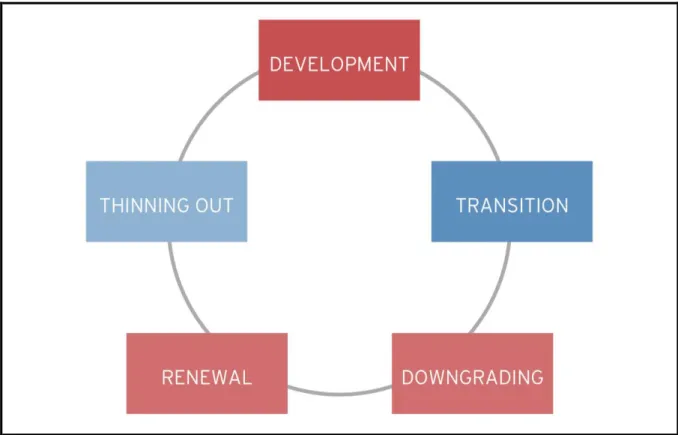
This argument can be seen as having been what led to the emergence of the neighborhood life cycle theory, which also belongs to the ecological school of thought. This life cycle consists of the five stages that neighborhoods are thought to eventually experience.
The Sub-Cultural Theory
There are several factors that can influence a neighborhood's movement through different stages of the cycle. The final criticism from subculturalists concerns the way the ecological perspective views neighborhoods as homogeneous.
The Political Economy
Subculturalists argue that neighborhoods can remain stable and possibly improve as long as their social structure is strong (Pitkin, 2001). Essentially, theorists believe that while there are various structuring forces that influence neighborhood change, it is not always a given that neighborhoods will yield to the forces of change.
Urban Decay
This can be observed when considering the relationship between the physical features that Brandman (2011) identified with some of the economic issues of urban decay. The social characteristics of urban decay can also be observed in different ways, one example of which is change in the demographic composition of the area.
Urban Regeneration
These failures in an area's economic systems lead to the aforementioned physical hallmarks of decline. It is often assumed that the other social marker of decline is an increase in criminal activity in the area.
The Twin Impacts of Globalisation and Urbanisation
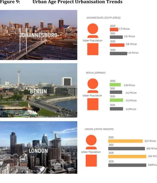
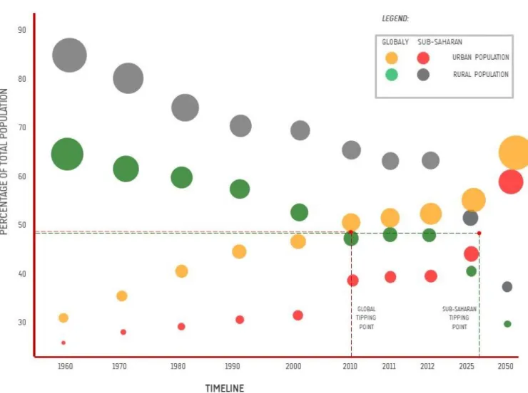
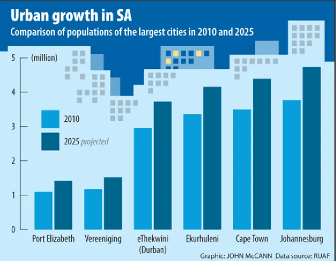
The year 2010 marked the global tipping point for the world's population, as for the first time more people in the world lived in urban settlements. This increase in urban population is also evident at a city-specific level, as reflected in the following graphs showing the degree of urbanization in six cities around the world chosen for the 2Urban Age project.
Conclusion
Introduction
Precedents from Developed Countries
Neighbourhoods in Detroit
These factories were heavily dependent on unskilled labor and as such the urban neighborhoods that were near the factories were predominantly working class. In addition to the automobile industry, the city center was home to numerous industrial plants, trade and world-famous entertainment areas.
Causes of Decay in Detroit
The money was carried in the pockets of the businesses and white people who fled as fast as they could." That was after a wave of business owners and wealthier earners in Detroit's predominantly white inner-city neighborhoods began moving to the suburbs on the outskirts of the CBD, fearing the violence and increasing looting.
The Response to the Decay of Detroit City
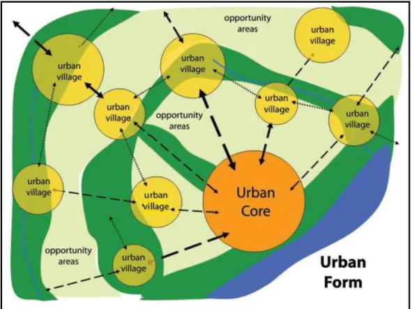
The immediate impact was an increase in unemployment and associated decay in downtown Detroit. The urban core, shown in Figure 6, would thus be a densely populated, compact and walkable mixed-use and mixed-income area with inner-city neighborhoods that offered different types of inner-city housing (ibid).
Neighbourhoods in Australia
The Causes of Decay in Brisbane
While the city recovered from the initial floods, the city later went through an intense drought between 1828 and 1829 (ibid). While Brisbane may have been an up-and-coming city with great potential and a growing population, the floods it experienced sent the city backwards in terms of development.
The Renewal of Brisbane
The case of Brisbane is an example of how in some cases deterioration can be triggered by a natural disaster, as in the case of the Brisbane floods. As part of the CBD, Albert Park is an area of rich heritage value and currently serves a variety of people.
Precedents and Experiences from Developing Countries
The Case Study of China’s Beijing Inner City
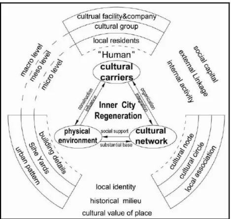
After an analysis of the state of the city's neighborhoods was conducted, 27 inner city areas were identified as in need of renewal. Cultural carriers were considered to have an effect on the physical environment in terms of building details, urban pattern or area structure, and uses to be developed in the area (Chun and Bin, 2008).
The Case of Sao Paulo, Brazil
The Causes of Decay in Sao Paulo
This flight of the wealthy, fueled by population growth and traffic congestion in downtown Sao Paulo, also led to the migration of some industrial activities from the inner city areas to the areas on the outskirts of the city (Cabral, 2013 ). This in turn led to a reduction in investment within the CBD as old industrial sites and buildings became vacant, resulting in the decline of Sao Paulo's downtown and inner-city neighborhoods.
Renewal Plans for Sao Paulo
One is able to observe a recurring pattern where an increase in population density, particularly of the low-income population, leads to a reduction in property investment, business and other infrastructure and services within inner-city neighborhoods, eventually leading to the decay of an area. . Although the project appears to be more biased towards housing, the informing vision is that it will lead to the revitalization of the inner city area in the center of Sao Paulo through investment in housing, urban public infrastructure and economic activities that will allow for increased employment.
Experiences from African Cities
The Case Study of Hillbrow/ Berea in Johannesburg, South Africa
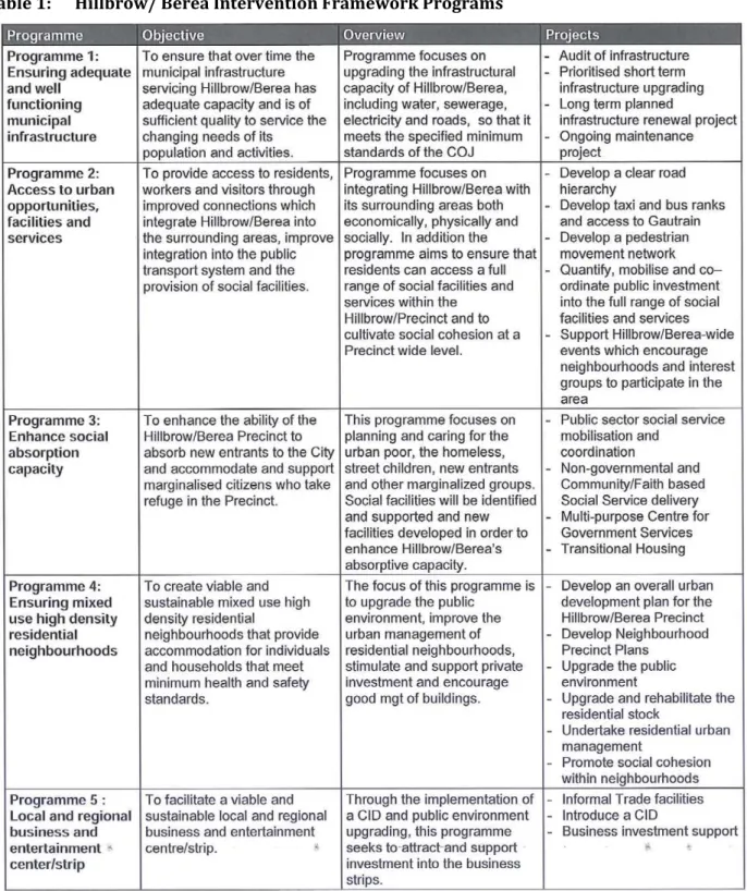
As Hillbrow/Berea became racially cosmopolitan, a negative identity also began to develop, leading to. The Hillbrow/Berea Intervention Framework (HIF) is currently being implemented as part of the City of Johannesburg's City Center Regeneration Initiative.
Conclusion
However, a key observation and lesson is that of the integrated and coordinated approach that has been adopted and is being implemented as a means of addressing the areas current condition. Also key to point out is the emphasis on urban management adopted to address decay in Hillbrow.
Introduction
Research Methods
The Case Study Focus
Using this particular neighborhood as a case study for a town planning research project provides a unique opportunity for potential solutions to the existing problems in Albert Park to be highlighted.
Qualitative Research Methods
When researching an area like Albert Park, it is important to be able to hear the different voices of those who have a role to play in the management of the area. The reason for acquiring the different perspectives of different stakeholders in relation to Albert Park was to be able to establish a broad understanding of the area.
Quantitative Research Methods
In order to gain a clear understanding of the situation in Albert Park and to be able to make meaningful proposals, it was important to understand the perspective of those who experienced the neighborhood on a daily basis. After receiving the survey results, an analysis of the responses was carried out based on each theme.
Data Sources
Primary Data Sources
Contact was made with a local resident who then identified members of the local communities who were willing to participate in the study.
Secondary Data Sources
Data Analysis
Primary Data
As stated in the method, the primary data was collected through individual interviews with selected stakeholders. Data collected from the interviews, which were qualitative, were analyzed thematically with the aim of highlighting the different stakeholders' perspectives on the themes being researched.
Secondary Data
Other data is presented in the form of maps or plans as well as graphs prepared by the researcher to better communicate his findings.
The Limitations to the Study
Evaluating the Research Methodology & development of criteria
Concluding Comments
Introduction
Approach
A Historical Overview
The Apartheid City
Maylam (1996:26) tends to support this view by stating that “much of Durban's history has been in the twentieth century. The local state3 consistently sought to control space in the service of the city's predominantly white middle class.
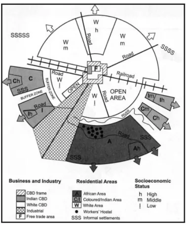
A Segregated Neighbourhood Contested
The 1980s saw an influx of non-white residents in several parts of the city, including Albert Park. It played a key role in mobilizing, organizing and protecting the rights of black tenants in Albert Park and other parts of the city (Freud and Padayachee, 2002).
Albert Park within Contemporary eThekwini
Planning and Design Framework
Developing the Design and Management Criteria from the Framework
Each of the pillars will be discussed separately and the criteria related to each pillar will be explained. An example of this is the urbanization problem discussed in the earlier chapters of the study.
A CRITERION Based Analysis
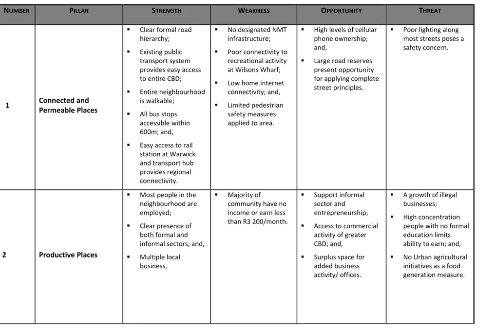
Connected and Permeable Places
This suggests that residents of Albert Park have access to a bus service within the. It would be ideal to improve the provision of ICT infrastructure and possibly have free access to the internet in Albert Park.
Productive Places
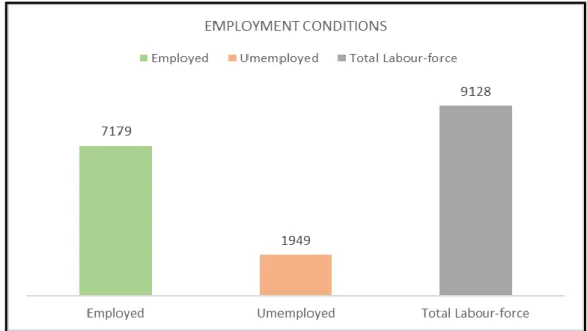
- Employment Conditions
- Household Income Levels
- Most Active Employment Sectors
- External and Internal Economic Opportunities
- The Potential/Ability to Earn an Income
As shown below, the highest concentration of low-income households in Albert Park is to the west of Joseph Nduli Street. As shown in Map 18, the majority of Albert Park's working residents are employed in the formal sector.
Spatially Efficient Places
Population Density and Distribution
Therefore, in terms of density and based on the eThekwini City Densification Strategy, the Albert Park area is considered to be performing efficiently. It is also important to note the high population concentration in the block east of Joseph Nduli Street.
Diversity of Uses
This can be attributed to the various housing initiatives of the First Metro Social Housing Company which have seen the regeneration of various buildings in the area as reflected in the images below. In this particular area, the high level of population can be attributed to the existence of a recently renovated apartment block, which currently also serves as a university residence.
Underutilised and Poor Performing Spaces
Complete and Inclusive Places
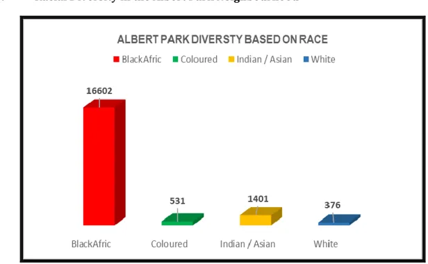
- The Diversity of Population
- The Residents’ Sense of Belonging
- The Housing Environment
- Access to Civic and Retail Facilities
Half of the participants indicated that they were attracted to the visual appearance of the Albert Park while the other 50% were not. The majority of participants indicated that they liked the fact that Albert Park was close to the city centre.
Ecologically resilient places
Productive Green Spaces
He further pointed out that one of the challenges of today and for the future is feeding the population in the city and that this is related to design. In the case of Albert Park, no analysis identified efforts to reserve space for roof gardens, community gardens or urban agriculture to support food production by and for the local community.
High Performance Buildings
The lecturer suggests that it is crucial to see cities as an ecosystem in which people are also included, and to establish ways to reduce waste and recycle it to work for the benefit of the city. However, a Local Area Plan (LAP) is currently being prepared for the CBD and it is anticipated that some of the proposals in this plan will begin to propose ecological strategies in line with the discussion above.
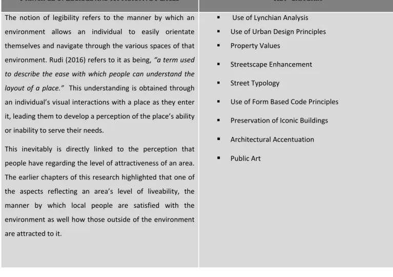
Legible and Attractive Places
A Lynchian Analysis
The following poster (Map 29) presents the Lynchian analysis carried out as part of this research in the Albert Park area. Aesthetic interventions were discussed in the chapter with the recommendations of the dissertation (see chapter seven).
Property Values
Technologically Advanced and Sustainable Serviced Places
Available Services
Well Managed Places
- Administrative Structure
- ITrump Districts
- Maintenance Systems
- Better Buildings Programme
This then leads to the identification, location and delivery of the building owner with a notice requiring action in response to the assessment's finding. Most of the residents are dissatisfied with the condition of the neighborhood but have nowhere else to go.
Concluding Comments
Introductory Comments
Revisiting the Research Aims and Objectives
In order to fully fulfill this objective in an adequate manner, several sub-objectives were outlined in the first chapter, each dealing with a specific facet of the overall objective. Each of these objectives has been unpacked in detail in the various chapters of this research and will continue to be so.
Revisiting the Research Hypothesis
It is therefore imperative that the approaches that officials use to plan, design and manage these environments are constantly abreast of the changes taking place or expected to take place in urban neighbourhoods. Using a design component, the research highlighted the importance of this aspect in creating regenerative plans for urban neighborhoods.
Recommendations for Albert Park
In general, it is expected that the methodology used for the research contributed to the successful outcome of the work undertaken. The Albert Park Management Association, which could be a collaboration between the city and selected residents of Albert Park to facilitate and manage the development of the neighbourhood.
Contribution to Research
Concluding Comments
The Location of Albert Park in eThekwini
They do not consider the neighborhood in the wider context of the city or as part of a wider system. This makes neighborhood streets safer and allows people to access different parts of the neighborhood on foot.
The Location of Albert Park within the Central Business District
The case study area of Albert Park is located within the boundary of the CBD as reflected in the map below. Although in the case of African cities, it can be argued that this is often determined by the financial state of the neighborhood in question.
Detroit in Michigan in the United States of America (USA)
The upper-class population, known to include white-collar workers, lived in the suburbs outside the city center. Downtown Detroit's neighborhoods played a supporting role in the motor vehicle manufacturing sector by ensuring that the workforce lived in close proximity to the plants.
Location of Brisbane
However, in the years that followed, it once again experienced a series of major floods, one of which destroyed every single bridge that crossed the river, as well as properties along the river banks. Alongside this was the protection of the city's heritage and character through the protection of various old buildings to preserve them and give the transformed city a unique identity of its own.
The Location of Beijing
Another event that played a major role in the decline of Beijing's inner-city neighborhoods was the Depression between 1959 and 1962. This exodus from the city led to the abandonment of a number of buildings and eventually to increased urban decay in the inner city.
The Location of Nonluogu Alley in Beijing
This and the development of various commercial and recreational activities along Nonluogo Street helped develop a greater sense of belonging and ownership of the area. While Sao Paulo's coffee boom may have brought economic benefits to the city and country, it also led to a large influx of poor European immigrants in the 19th century who came to work on the coffee plantations.
The Location of Sao Paulo
What may be more relevant is improving the services that already exist in the area. This showed that all residents in the Albert Park area are within walking distance of the park.
Hillbrow in the Context of Johannesburg Inner City
Albert Park Locality Plan
Internal Movement/Access within Albert Park
Broader Physical Connectivity
Access to Internet in Albert Park
Access to Telecommunication Infrastructure (Mobile Phones)
Concentrations of Unemployed Residents in Albert Park
Levels of Household Income
Employment Sectors
Zoning Map for Albert Park
Ability to Earn - Albert Park
Net Residential Densities
Population Concentrations in Albert Park
Diversity of Land Uses and Zoning in Albert Park
Spatial Performance in Albert Park
Population Map for Albert Park
Tenure Status in Albert Park
Access to Civic Facilities
Ecologically Resilient Places in Albert Park
Lynchian Analysis Albert Park
Property Values in Albert Park
Electrical Services in Albert Park
Maps of Sewer Service in Albert Park
Storm Water Services in Albert Park
Water Services Provisions in Albert Park
Administrative Boundaries of Albert Park
ITRUMP Districts
An Image of a Neighbourhood Edge and Centre, Plan and 3D Imagery
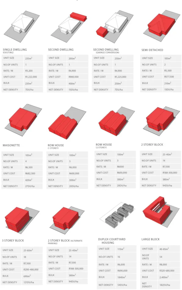
Figures 8 and 9 both show examples of choices in terms of unit types and land use activities to ensure the completeness of the district. The model posits that as the neighborhood transitions from one phase to another, it experiences several changes, including variation in the neighborhood's demographic status, and its racial and age composition.
Decayed Building in Johannesburg
However, there are cases where it is the change in the class of people within an area that ultimately triggers the entire urban decay phenomenon. Andersen (2003) gives evidence of the change in the class of people that eventually triggered the entire urban decay process in American experiences where trends changed and people began to develop a greater interest in suburban life.
An Abandoned Street running through the Packard Complex in Detroit, Michigan, in USA
Vibrant Detroit
The increase in white flight caused a decline in investment in downtown neighborhoods, resulting in many businesses having to close their doors or move to other states.
Detroit 12 th Street Riot
It was believed that the new building would attract back business owners from the older downtown areas and others who had moved away from the inner city. Other initiatives the city tried to pass included building a new stadium for a local baseball club and reviving the Fox Theater in an effort to keep the inner city as vibrant as it had been before.
An Abandoned House, Repurposed by the Homeless in Detroit’s Eastside
Two Faces of the City -the Renaissance Building Complexes with an Inner City House in
Therefore, the aim of the concept of urban form was "to create smaller, better functioning, more sustainable and interconnected communities suitable for living" (ibid; 22). It is also important to note the way in which the urban villages would be connected to the city center to allow easy travel for people who may work in the city center but want to live in the urban villages.
Brisbane in 1800’s
The first of these was unique in that it was a natural event beyond human control.
1893 Brisbane Flood
However, some of the key points to note from the way the City of Brisbane has responded to the decline are the way their response involved a variety of stakeholders through public partnerships, and the way the initiative aimed to to ensure adaptive design, which recognizes the idea that cities are dynamic and constantly evolving, with the needs of the population also changing. As such, it is important that any interventions ensure that the history of the area is not eroded and that extensive stakeholder engagement processes are carried out.
Street Pattern Inner-City Beijing and Traditional Beijing Siheyuan
Crowded Conditions in Siheyuan
It is important to note that the program is not limited to inner-city neighborhoods, but covers the city as a whole. While the city may have experienced economic growth due to the expanding manufacturing industry, very little was invested in developing or modernizing downtown neighborhoods, where the majority of the workforce lived.
In 1986, the Council decided to request the government to abolish the operation of the Group Areas Act in the city of Durban. The analysis section that follows will delve deeper into the analysis of the current state of the Albert Park area.
The combination of the findings from these two maps reflects that residents in the Albert Park area are already internet users. Do you think the urban development initiatives in the Albert Park area could be useful?
As shown in the pictures that follow (plates 20 to 23), the park currently has a football field which is used a lot, especially at the weekend and at certain times during the week. The park also has other sports facilities that include a basketball and basketball court.
As part of the whole process, the task force must also identify key projects that can be implemented by the municipality, thus serving as catalysts for the revitalization of the neighborhood. Community Feeling and Neighborhood Form: An Assessment of the Social Doctrine of New Urbanism.