A STUDY OF THE NATURAL AND ANTHROPOGENIC IMPACTS ON THE SEDIMENT AND WATER QUALITY OF THE MIDDLE AND LOWER MVOTI RIVER
SYSTEM, KWAZULU NATAL, SOUTH AFRICA
by
PRISHA SUKDEO (204005541)
Submitted in fulfilment of the academic requirements for the degree of Master of Science, in the School of Environmental Science,
Faculty of Science and Agriculture, University of KwaZulu Natal, Durban
December 2010
ABSTRACT
This dissertation focussed on the Mvoti River system in KwaZulu-Natal, an important resource for the numerous towns and villages along its course. Catchment activities are varied with agriculture being the predominant activity, and industrial activities common in the lower catchment. The Mvoti River is intensively utilized, especially in its lower reaches, to the extent that it is referred to as a ‘working river’. Modifications of the chemical and physical characteristics of the system, and consequently the biological characteristics, have led to degradation of the system such that the functioning of the lower river has deteriorated in comparison to that of its pre-disturbance condition. There are three main aspects of the Mvoti system around which this dissertation is based, namely, water quality, geochemistry, and conservation of the system.
The results of the water quality survey of the estuary revealed that the system is presently experiencing water which is of an inferior quality. Compared against the South African water quality standards, a majority of the parameters exceed acceptable limits and are likely to present negative impacts on aquatic health and potentially human health. Comparison of current results, and water quality data for the system dating back to 1964, revealed that this degradation is not new to the system, and the Mvoti Estuary has in fact been experiencing continued deterioration over the years.
The second part of this study investigated heavy metal presence in the sediments of the lower system and elemental presence and distribution in the surface sediments of the middle and lower River respectively. Results indicated that even though selected heavy metals are present, they are of concentrations lower than those of two other South African and two other international systems they were compared with.
Enrichment and contamination assessments reveal that contaminants are in all probability present as a result of anthropogenic sources. However, distribution patterns which show highest levels just after effluent disposal sites suggest that the contamination is presumably human-induced and, the predominance of larger grained sediments that do not have high adsorption capacities, suggest that contaminants are readily remobilized into the water column.
The final part of this research investigates other environmental problems, and causes, both natural and anthropogenic, experienced by the estuary system. These stresses include poor water quality, reduced water quantity, sedimentation, alien vegetation invasions and loss of biodiversity. Strategies to address these issues are proposed, with the intention of improving the condition of the estuary. This is an attempt at ecological restoration, to restore the estuary to a condition as close to as possible, to its pre-disturbance condition. These strategies include controlling abstraction and discharge, eradicating alien vegetation, controlling sandmining, and improving the overall quality of the system. Also proposed is an estuary management plan (EMP) for the Mvoti system, as there is currently no plan of such a nature in place. The EMP will aid restoration attempts, increase public awareness, and via post-project monitoring and evaluation ensure the success and sustainability of any future projects. Significantly, the adoption of an EMP will be a major step towards the rehabilitation, conservation and protection of this already degraded system.
PREFACE
The experimental work described in this dissertation was carried out in the School of Environmental Sciences, University of KwaZulu-Natal, Durban, from March 2009 to March 2010, under the supervision of Dr. S. Pillay.
These studies represent original work by the author and have not otherwise been submitted in any form for any degree or diploma to any tertiary institution. Where use has been made of the work of others it is duly acknowledged in the text.
DECLARATION 1: PLAGARISM
I, Prisha Sukdeo, declare that
1. The research reported in this thesis, except where otherwise indicated, is my original research.
2. This thesis has not been submitted for any degree or examination at any other university.
3. This thesis does not contain other persons’ data, pictures, graphs of other information unless specifically acknowledged as being sourced from other persons.
4. This thesis does not contain other persons’ writing, unless specifically acknowledged as being sourced from other researchers. Where other written sources have been quoted, then:
a. Their words have been re-written but the general information attributed to them has been referenced
b. Where their exact words have been used, then their writing has been placed in italics and inside quotation marks, and referenced.
5. This thesis does not contain text, graphics or tables copied and pasted from the Internet, unless specifically acknowledged, and the source being detailed in the thesis and in the Reference sections.
Signed: ________________
DECLARATION 2: PUBLICATONS AND CONFERENCE PROCEEDINGS
1. Sukdeo, P., Pillay, S., Bissessur, A., Chili, N. S., and Desai, A. In Review.
Deteriorations in the water quality of the Mvoti Estuary: implications for aquatic ecosystems and domestic use. Water SA.
2. Sukdeo, P., Pillay, S., & Bissessur, A. In Review. A study of the presence of heavy metals in the sediments of the lower Mvoti River system and its comparison to other ecologically important systems. South African Geographical Journal.
3. Sukdeo, P., Pillay, S., & Bissessur, A. In Review. A geochemical assessment of the middle and lower Mvoti River system, KwaZulu-Natal, South Africa. Environmental Earth Sciences.
4. Sukdeo, P., Pillay, S., & Bissessur, A. In Review. Ecological Restoration of a Degraded Estuary: The Case of the Mvoti Estuary, KwaZulu-Natal, South Africa.
Environmental Conservation.
5. Sukdeo, P., Pillay, S., & Bissessur, A. (2010). A proposal for the restoration and management of the lower Mvoti River and Estuary, KwaZulu-Natal, South Africa.
Research Paper presented at the InSym-SUSL 2010, Sabaragamuwa University of Sri Lanka. 26th – 28th August 2010. In consideration for publication in conference proceedings.
Signed: ________________
TABLE OF CONTENTS
ABSTRACT i
PREFACE iii
DECLARATION 1: PLAGARISM iv
DECLARATION 2: PUBLICATIONS v
TABLE OF CONTENTS vi
LIST OF FIGURES xiv
LIST OF TABLES xvi
LIST OF ABBREVIATIONS xvii
ACKNOWLEDGEMENTS xviii
CHAPTER ONE: GENERAL INTRODUCTION AND
THEORETICAL BACKGROUND 1
1.1. Introduction 1
1.2. Contextualization of the problem and motivation for the study 3
1.3. Aim and Objectives 5
1.4. Structure of the Dissertation 6
1.5. Introduction to the literature review 7
1.6. Review of past research on the Mvoti System 7
1.7. River systems 8
1.8. River catchments and their influence on the river system 9
1.9. Estuaries 10
1.10. Estuarine classifications 11
1.10.1. Permanently open estuaries 12
1.10.2. Barred open estuaries 12
1.10.3. River dominated estuaries 13
1.10.4. Microtidal & Perched estuaries 14
1.11. Factors influencing aquatic systems 14
1.11.1. Anthropogenic activities 15
Urban sector 15
Agricultural sector 16
Industrial sector 16
1.11.2. Natural Processes 17
1.12. Water quality 18
1.12.1. Impacts of poor water quality 18
Water related diseases 18
Eutrophication 19
Degradation of aquatic ecosystems 19
1.12.2. Water quality guidelines 20
1.13. Catchment Derived sediments 21
1.13.1. Granulometry 21
1.13.2. Geochemistry 22
1.13.3. Aquatic sediments as a sink for pollutants 23
1.13.4. Contaminant - Sediment Relationship 24
1.13.5. Background values 24
1.14. Common physico-chemical parameters affecting aquatic systems 25
1.14.1. Physical characteristics 25
1.14.2. Nutrients and chemical characteristics 26
pH 26
Ammonium Ions 26
Chloride 27
Nitrate 27
Sulphate Ions 27
1.14.3. Heavy metals and other elements 27
Aluminium (Al) 28
Arsenic (As) 29
Barium (Ba) 29
Boron (B) 29
Calcium (Ca) 30
Chromium (Cr) 30
Cobalt (Co) 30
Copper (Cu) 30
Iron (Fe) 31
Lead (Pb) 31
Magnesium (Mg) 31
Manganese (Mn) 31
Molybdenum (Mo) 32
Nickel (Ni) 32
Phosphorous (P) 32
Potassium (K) 32
Selenium (Se) 33
Silicon (Si) 33
Sodium (Na) 33
Strontium (Sr) 33
Titanium (Ti) 34
Vanadium (V) 34
Zinc (Zn) 34
1.15. Degraded systems and ecological restoration 34
1.16. Policy and legislation relating to the protection of water and aquatic resources
in South Africa 36
1.17. Conclusion 37
CHAPTER TWO: REGIONAL SETTING AND RESEARCH METHODOLOGY 38
2.1. Introduction 38
2.2. Regional physiographic description 38
2.2.1. Topology of KwaZulu-Natal 39
2.2.2. Hydrodynamics of the KwaZulu-Natal coastline 40
2.2.3. General climatology 40
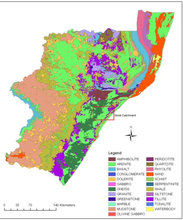
2.2.4. Geology 42
2.3. The Mvoti River System 43
2.3.1. The Mvoti River and catchment characteristics 43
2.3.2. The Mvoti Estuary 45
Morphometric characteristics 46
Nature of bottom materials 46
2.4. Site Selection 46
2.4.1. The Riverine Sites 47
2.4.2. The Estuarine Sites 48
2.5. Sampling Protocol 51
2.6. Chemical Analysis 52
2.6.1. In Situ Recordings 52
2.6.2. Ion Chromatography 52
2.6.3. Flame Photometry 53
2.6.4. Inductively-coupled plasma optic emission spectrometry 53
2.7. Granulometric analysis 54
2.8. Data Analysis 54
2.8.1. Statistical analysis 54
2.8.2. Pollution assessments 54
Contamination Factors (CF) 55
Enrichment Factors (EF) 55
Pollution Load Index (PLi) 56
2.9. Conclusion 56
CHAPTER THREE: THE WATER QUALITY OF THE MVOTI ESTUARY 57
3.1. Abstract 58
3.2. Introduction 59
3.3. Methodology 61
3.3.1. Sample Collection and Chemical Analysis 61
3.3.2. Statistical Analysis and Comparisons 62
3.4. Results and Discussion 62
3.4.1. Dissolved Oxygen 64
3.4.2. Conductivity 65
3.4.3. Nitrate 66
3.4.4. Ammonium ions 67
3.4.5. Chloride 68
3.4.6. Sulphate 70
3.4.7. Sodium 70
3.4.8. Calcium 71
3.4.9. pH 72
3.5. Conclusion 73
CHAPTER FOUR: HEAVY METALS IN THE SEDIMENTS OF
THE LOWER MVOTI RIVER SYSTEM 74
4.1. Abstract 75
4.2. Introduction 76
4.3. Materials and Methods 78
4.3.1. Sampling Sites 78
4.3.2. Sediment particle size analysis 80
4.3.3. Statistical analysis 80
4.4. Results and Discussion 81
4.5. Conclusion 86
CHAPTER FIVE: A GEOCHEMICAL ASSESSMENT OF THE SURFACE SEDIMENTS
OF THE MIDDLE AND LOWER MVOTI RIVER SYSTEM 87
5.1. Abstract 88
5.2. Introduction 89
5.3. Materials and Methods 91
5.3.1. Sampling sites and sediment collection 91
5.3.2. Grain-size determination and Chemical analysis 92
Determination of Contamination Factors 92
Determination of Enrichment Factors 93
Determination of the Pollution Load Index 94
5.4. Results and Discussion 94
5.4.1. Geochemical distribution: grain size analysis and elemental presence 94
5.4.2. Contamination Factors (CF) 95
5.4.3. Enrichment Factors 99
5.4.4. Pollution Load Index 100
5.5. Conclusion 101
CHAPTER SIX: ECOLOGICAL RESTORATION AND MANAGEMENT OF
THE MVOTI ESTUARY 102
PART I: RESTORATION AND REHABILITATION OF THE MVOTI ESTUARY 103
6.1. Abstract 103
6.2. Introduction 104
6.3. Study area 104
6.4. Current environmental problems 106
6.4.1. Water quality 107
6.4.2. Water abstraction and siltation 107
6.4.3. Habitat integrity and species diversity 108
6.4.4. Sandmining 109
6.4.5. Alien Vegetation 110
6.5.Restoration and Management of the Mvoti Estuary 111
6.5.1. Water Quality 114
6.5.2. Reducing Sedimentation 115
6.5.3. Minimizing Water Abstraction 115
6.5.4. Eradicating Alien Vegetation 116
6.5.5. Improving Habitat Integrity 116
6.6. Conclusion 117
PART II: AN ESTUARY MANAGEMENT PLAN FOR THE MVOTI ESTUARY 119
6.7. Introduction 119
6.8. Situational assessment 119
6.8.1. Goods & services provided by the estuary 120 6.8.2. Issues relating to the exploitation of living resources 120 6.8.3. Assessment of the water quality and quantity requirements 120
6.8.4. Priority restoration actions 121
6.8.5. Protected area potential 121
6.8.6. Awareness raising & public participation/ stakeholder involvement 122
6.9. Estuarine Management Plan 122
6.9.1. Vision statement for the Mvoti estuary 123
6.9.2. Management Objectives 123
Pollution control 123
Restoration of the estuary 124
Conservation of biodiversity 124
Increase public awareness 124
Increase economic potential without exploiting resources 125
6.10. Strategies to meet key management objectives 125
6.10.1. Key strategies for restoration of the estuary 125
6.10.2. Controlling pollution in the estuary 126
6.10.3. Conserving biodiversity 127
6.10.4. Strategies to increase public awareness 127
6.10.5. Increasing the economic potential of the estuary 128 6.11. The proposed Mvoti estuary protected area & zonation 128
6.11.1. The proposed protected area 129
6.11.2. Boundaries of the proposed marine protected area 131
Zone A 131
Zone B 131
Zone C 132
Zone D 132
6.11.3. Development set back zone around the estuary 132 6.11.4. Establishment of a terrestrial protected area. 133 6.12. Co-operative Governance and estuary management forums 134
6.13. Post-project monitoring and evaluation 135
6.14. Conclusion 136
CHAPTER SEVEN: CONCLUSION 137
7.1. Conclusion and key findings of this study 137
7.2. Recommendations 138
REFERENCES 139
APPENDIX A 152
LIST OF FIGURES
Figure 1.1. Conceptual morphodynamic classification of microtidal estuaries 12 Figure 1.2. Generalised morphology of a river-dominated estuary in plan (a) and
cross-section (b) 13
Figure 1.3. Generalised morphology of a perched estuary in plan 14
Figure 2.1. (a) The Mvoti River catchment 38
Figure 2.1. (b) The Mvoti River catchment and a representation of its division into the
upper, middle and lower Mvoti regions 39
Figure 2.2. The geology of KwaZulu-Natal 42
Figure. 2.3. The generalised land cover of the Mvoti catchment 44 Figure. 2.4. Agricultural land cover in the Mvoti catchment 45 Figure 2.5. The location of the Mvoti Estuary on the KwaZulu-Natal coast 45 Figure 2.6. Representation of the sample sites on the Mvoti Estuary 49 Figure 2.7. Sample sites selected along the middle and lower reaches of
the Mvoti River 50
Figure 2.8. (a) The 650 MDS Multiparameter Display System and (b) The 6920
Multiparameter Sonde 51
Figure 3.1. Schematic representation of the Mvoti Estuary and sampling transects 61 Figure 3.2. Changes in the levels of dissolved oxygen in the Mvoti Estuary between
1964 and 2010 64
Figure 3.3. Changes in the levels of conductivity in the Mvoti Estuary between
1964 and 2010 65
Figure 3.4. Changes in the levels of nitrates in the Mvoti Estuary between
1964 and 2010 67
Figure 3.5. Changes in the levels of ammonium ions in the Mvoti Estuary between
1964 and 2010 68
Figure 3.6. Changes in the levels of chloride in the Mvoti Estuary between
1964 and 2010 69
Figure 3.7. Changes in the levels of sulphate ions in the Mvoti Estuary between
1964 and 2010 70
Figure 3.8. Changes in the levels of sodium ions in the Mvoti Estuary between
1964 and 2010 71
Figure 3.9. Changes in the levels of calcium in the Mvoti Estuary between
1964 and 2010 71
Figure 3.10. Changes in the pH levels of the Mvoti Estuary between
1964 and 2010 72
Figure 4.1. Location of the Mvoti Estuary in relation to the St. Lucia and
Swartkops Estuaries along the South African coastline 79
Figure 4.2. Map of the lower Mvoti river and estuarine system indicating the sampling
sites selected for the study 79
Figure 5.1. The fate of non-degradable elements in aquatic systems 90 Figure 5.2. Schematic representation of the sampling sites (E1-E2, R1-R5) for
geochemical and grain size analysis 91
Figure 5.3. PLi values at the different sample sites along the Mvoti River 100 Figure 6.1. Schematic representation of the Mvoti Estuary along the South African
coastline 106
Figure 6.2. Impacts of sugarcane farming and sugar milling on estuarine productivity 109 Figure 6.3. The proposed rehabilitation and management plan for the lower
Mvoti River and Estuary 118
Figure 6.4. The Proposed National Estuarine Management Protocol 122 Figure 6.5. Key strategies for the restoration of the estuary 126
Figure 6.6. The Zulu palm veld in Groutville 130
Figure 6.7. Zonation plan for the proposed Mvoti marine protected area 132 Figure 6.8. The proposed Mvoti terrestrial protected area 134
Figure 6.9. Seven key steps to post-project evaluation 136
LIST OF TABLES
Table 3.1. Measurements of the Water Quality parameters recorded at the
Mvoti Estuary in 1964 (after Begg, 1978), 2000 (MacKay et al., 2000a), and 2010 63 Table 4.1. Heavy metal concentrations (ppm) and mean at each sample site 82 Table 4.2. Heavy metals (ppm) within the sediments of the St. Lucia Estuary and the
Mvoti Estuary 84
Table 4.3. Comparative amounts of heavy metals (ppm) within the sediments of two
international and two South African estuaries 85
Table 5.1. Mean concentration (ppm) of elements present within the sediments of
the sample sites 96
Table 5.2. Contamination factors of elements present within the sediments of the
sample sites 97
Table 5.3. Enrichment Factors of elements present within the sediments of the
sample sites 98
Table 6.1. The activities and consequent impacts associated with sandmining on the
lower Mvoti River 110
LIST OF ABBREVIATIONS CF Contamination Factor
DEAT Department of Environmental Affairs and Tourism DWAF Department of Water Affairs and Forestry
EF Enrichment Factor
EMP Estuary Management Plan
ICP-OES Inductively Coupled Plasma Optical Emission Spectrometry KDM Kwa Dukuza Municipality
MPA Marine Protected Area PLi Pollution Load Index SOER State of Estuaries Report
ACKNOWLEDGEMENTS
The financial assistance of the National Research Foundation (NRF) towards this research is hereby acknowledged. Opinions expressed and conclusions arrived at, are those of the authors and are not necessarily to be attributed to the NRF.
A number of people have contributed in various ways towards the completion of this study. I am grateful to those who have offered encouragement, or who have contributed in effort and time. In particular, I would like the following people:
My family – mum, dad, Shane and Dinny. Thanks for all your love, encouragement and patience, and for always believing in me. Thanks also for transport assistance, help with fieldwork, and making sure I stayed sane. To my awesome pets, thank you for you faithful companionship. I love you all very much!
My supervisor, Dr. Srinivasan Pillay, thank you so much for your direction, assistance, and tolerance throughout this study. Thanks also for guidance and transport during site visits.
Mr. Edward Powys, thanks for your help during field studies, and for allowing me the use of the map library resources. Mr Shaeen Chetty, thank you for your help with chemical analysis. Mr. V. Devan, thanks for assisting me with the GIS maps.
Mr Ajay Bissessur, thank you for assisting with the chemistry aspect of this study and helping me understand the various principles and procedures.
Mr. Jay Prithipal and his family, for assisting me with the printing of this dissertation.
Lastly, to all my friends at Westville campus, especially Zayd Goolam Hoosen, thanks for your friendship, support, and assistance.
The rapid expansion of human activities worldwide coupled with exponential population growth, has created immense stress on the environment and natural resources. These factors contribute to the diminishing status of a variety of resources including the global freshwater reserve. Water is a fundamental resource for all life on earth (Naidoo, 2005; Phiri et al., 2005; Graham and Farmer, 2007). Despite its importance, water is often a victim of pollution and over-exploitation (DEAT, 2005). Accordingly, it is essential that this resource be efficiently and vigilantly managed and protected.
Adequate water is required in order for humans, and aquatic and terrestrial ecosystems to survive. For these systems to function at their optimum, it is important not only for appropriate amounts of water to be available (French, 1997), but also for this water to be fit in terms of its quality (chemical and physical), for usage by both human and non human consumers (DEAT, 2006).
South Africa is a semi-arid country (Naidoo, 2005; Bucas, 2006), receiving an average rainfall of approximately 450 mm per year (DEAT, 2006). The distribution of rainfall in the country is variable and uneven (Bucas, 2006), with the western and northern part of the country receiving substantially less rainfall than the southern and eastern regions (DEAT, 2006). The management and protection of water resources is particularly necessary in South Africa, which is considered a water-stressed country according to the United Nations definition, i.e. the availability of less than 1700 m³/person/year (DEAT, 2005). In South Africa, rivers provide a vast majority of the exploitable water resource available (O’ Keeffe, 1986). It has been predicted that fresh water will one day be the factor that limits South Africa’s economic prosperity (O’ Keeffe, 1986) and until then rivers will continue to be exploited.
Surface water bodies, especially rivers, are of particular importance in South Africa as they are the principle providers of water in the country (DEAT, 2006). Ground water is also utilized to an extent, more so in arid regions.
However, surface water is the preferred option, and the uneven distribution of water resources in the country is often overcome via inter-basin transfers of water from rivers (DEAT, 2006). South Africa’s water resources presently exist within nineteen key water management areas (WMA), each comprising of individual tertiary catchments (DEAT, 2006;
SOER, 2007). Apart from water, river systems are also important with regards to sources of food and sediments (building material), transport options, recreational areas, and disposal sites for irresponsible discharges of effluent.
Since the earliest days of civilization, rivers have always been and still are focal points for development, holding key roles in local and global economies (King et al., 2003). Globally, river-modifications have gradually changed the distribution and nature of surface waters (King et al., 2003). During the last few decades, manipulations of rivers have become increasingly extensive with the rapid development of dams and impoundments, inter-basin transfers, and catchment activities which affect the water resource (King et al., 2003). Other modifications include channelization, canalization, waste disposal, and the alterations of river courses to suit land use requirements (Viles and Spencer, 1995; King et al., 2003).
River systems and estuaries are important components of our physical environment as they play an integral role in the survival of a variety of life forms on earth (Munien, 2006). The use of water resources inland and in coastal areas affects the functioning of rivers, estuaries and coastal waters (French, 1997; King et al., 2003; DEAT, 2005). Activities occurring within the catchments of these river systems also affect the health and functioning of these rivers and estuarine ecosystems (Viles & Spencer, 1995; French, 1997; Davies and Day, 1998). This is mainly due to the fact that water in rivers is derived either from groundwater which has seeped though from the surface or directly from surface runoff (Dame and Allen, 1996), and eventually ends up in estuaries. Rivers therefore receive and serve as the conduit for the catchment’s water and other material (in dissolved or solid state) which are conveyed in most cases to the marine environment via estuaries, especially urban rivers which are often considered as pollutant sinks and sometimes source (Scholes et al., 2008). Estuaries, therefore act as temporary sinks for materials, sediments, and nutrients derived from the catchment (Viles & Spencer, 1995; Lindsay and Bell, 1997), before these are eventually flushed out to sea.
The unlimited and convenient access to natural resources and water supply that most river systems and estuaries provide create ideal locations for industrial, agricultural and residential developments, making these environments vulnerable to degradation (Munien, 2006).
Furthermore, factors such as geology, vegetation and land use of the entire catchment all contribute in some way to quality of water entering rivers and consequently estuaries (O’
Keeffe, 1986). Apart from water use, land use and other practices within the catchment, and natural processes such as weathering and erosion, climate change has been identified as a factor which may affect our water resources by influencing rainfall quantity and distribution, as well as evaporation rates (DEAT, 2006; Graham and Farmer, 2007).
Estuaries, being the interface between rivers and the sea (Anthony et al.,2002), are highly important and unpredictable areas along the coastline (Glennie, 2001) and provide us with a wide range of biological ‘services’ and goods such as, raw materials, areas for recreational activities and scenic views (Mander, 2001). Estuaries are also able to control flooding, to provide sediment to sustain beaches, and to control erosion by the growth of estuarine vegetation (Mander, 2001). Currently, estuaries are also popular sites for industrial and harbour development together with domestic and industrial effluent discharge (DEAT, 2001).
Population growth and development in and around estuaries and river systems, in addition to exploitation of the resources they provide (Mander, 2001) are placing increasing pressure on the health and functioning of these ecosystems (DEAT, 2001).
According to Allanson (2001), in the last century human activities in South Africa have altered the natural progression of changes in riverine and estuarine geomorphology, accelerating it, by means of increasing impoundments on rivers and decreasing inflow into estuaries, or by over-abstraction of water. This in turn can result in destruction of the estuary, or consolidation of estuarine sediments and increased sandbar formations (Allanson, 2001).
Globally, land and water developments and interrelations have brought many benefits to humankind, however, they have also resulted in a decrease in the ecological form and functioning of fluvial systems (King et al., 2003). The implications of these declines are increasingly recognized, in terms of decreasing water quality, decreasing natural, aquatic resources available, sedimentation of storage bodies, loss of biodiversity, over and above the national costs associated with rectifying these issues (King et al., 2003).
Consequently, river research concerned with these stresses, their causes, as well as mitigation measures are being progressively more attempted. However, constructive and meaningful river research of this nature is still relatively young in South Africa (King et al., 2003).
The protection of water and aquatic resources is of vital importance in South Africa (Malan and Day, 2002). Rivers are capable of replenishing themselves via a self-cleansing function.
However, when rivers are subjected to stresses like pollution and excessive water abstraction, their functioning as an ecosystem is compromised (Malan and Day, 2002), and this often affects their self-cleansing capabilities. With continued stress and impaired self- cleansing abilities, the quality of the system experiences further declines, and the use of the water resource becomes limited (Malan and Day, 2002). As noted by Malan and Day (2002), water is a limited resource in South Africa, and consequently pollutants cannot always be dealt with via dilution.
Effluent disposals and high abstraction rates coupled with high evaporation rates, have led to increased concentrations of pollutants in water bodies. Pollutants in the water column often reach toxic levels and present adverse effects on biota and human health (Orr, 2007).
Pollutants also accumulate within sediments, and can be remobilised into the water column via various processes, re-contaminating the system (Chenhall et al., 2004; Lin et al., 2007;
Harikumar and Jisha 2010). Common sources of pollutants of rivers include urban and agricultural activities (litter, various chemicals, organic waste, pesticides, fungicides and fertilizers), industrial effluents (various chemical and synthetic compounds, organic waste, dyes, and waste water used in washing/cooling processes), as well as natural processes (catchment geology, weathering and erosion). It is therefore of particular importance, that river systems be assessed and monitored, in terms of their water quantity and quality, sediment quality, as well as biotic integrity.
The Mvoti River is an intensively utilized system particularly in its lower reaches. Here the river is subjected to major influences from the local industries, in the forms of alterations of the main channel, water abstraction, together with milling and sewage effluent discharges which enter the river via the Mbozambo and Ntshaweni tributaries. These effluents enter the Mvoti River approximately 7 km upstream of the Mvoti Estuary, and have consequently presented a range of implications for this system over the years. The lower Mvoti River is severely degraded such that the river functioning is completely different to what it was in its pre-disturbance condition (MacKay et al., 2000b).
Other influences on the system include extensive agriculture in the upper (forestry) and lower (sugarcane farming) catchment, sandmining, and diverse settlements ranging from urban, to rural, to informal. As catchment activities are a pivotal influence on river systems, these should also be considered in terms of their assessment and monitoring, i.e. a catchment approach should be implemented. The impacts of this myriad of activities and influences on the Mvoti has been investigated over the years (Tharme, 1996; Malherbe,
2006, Munien, 2006; Von Bratt, 2008, Chili, 2008). These studies have however been primarily concerned with the Mvoti Estuary and the lower reaches of the river. Preference has also been predominantly awarded to investigating the industrial effects on water quality and biotic characteristics of the system.
The primary focus of this study is therefore to view the system as a whole, encompassing the middle, lower and estuarine sections of the Mvoti River, in the assessment of both anthropogenic and natural effects, on the water quality and sediment contamination (of which there is little known) of the system. Despite its importance as a resource to a number of towns and industries, as well as its persistently deteriorating condition, there are currently no measures in place to monitor and manage the system, or to promote its conservation.
The aim of this study is to asses the natural and anthropogenic effects on the water and sediment quality of the middle and lower Mvoti River system.
The main objectives of this study, set out to achieve the aim are as follows:
To assess the current water quality of the Mvoti Estuary and appraise deteriorations in the system over the last four decades (Chapter 3).
To determine the presence of selected heavy metals in the sediments of the lower Mvoti River and estuary in relation to other ecologically significant systems (Chapter 4).
To assess the geochemical enrichment and pollution status of the middle and lower Mvoti River sediments (Chapter 5).
To develop a proposal for the ecological restoration of the lower Mvoti River and estuary system (Chapter 6: Part I).
To develop a potential estuary management plan for the Mvoti Estuary (Chapter 6:
Part II).
! "
Chapters three to six of this thesis are based upon individual papers that have been submitted to peer-reviewed journals. The journals together with the title of the papers are presented at the beginning of each respective chapter.
Chapter One outlines briefly previous research conducted on the lower Mvoti system and their respective areas of focus. In addition, this section also discusses the various literature and theoretical concepts upon which this study is based. Key areas reviewed in this chapter include rivers, estuaries and their catchments, physico-chemical characteristics of aquatic systems, factors affecting them, as well as ecological degradation and restoration.
Chapter Two describes the physical characteristics of the study area and its regional setting, together with a brief description of the research methodology adopted in this study. It includes the selection of sample sites, field collection, descriptions of the chemical analysis conducted on the samples, other laboratory procedures including sediment analysis, as well as methods of data analysis. Chapter Three presents the results of the water quality analysis, to provide a description of the current conditions prevalent in the system. The implications the current water quality has for aquatic health and human use is also discussed, together with a comparison of existing data and present conditions to assess the deteriorations that have occurred in the system.
The fourth chapter discusses the results of the heavy metal analysis conducted on the sediments of the lower river and estuary. Varying land uses are catchment activities can have considerable detrimental effects on the levels of pollutants in freshwater systems. Of these pollutants, heavy metals are of particular concern due to their persistent and accumulative nature. The results are compared to data available for two South African, and two international systems. Chapter Five presents the findings of the geochemical assessment conducted on the sediments of the middle and lower Mvoti River. Here, elemental presence and distribution are discussed, along with pollution assessments of the system.
The sixth chapter (Part I) identifies environmental stresses imposed upon the lower Mvoti River and Estuary, the resultant impacts on the system, plus viable strategies to ecologically restore this degraded system. Part II of this chapter is a potential estuary management plan for the Mvoti Estuary, whilst the seventh and final chapter outlines the conclusions of the study, and recommendations for future research.
# $
This remaining section of this chapter presents a review of the literature and theoretical concepts upon which this research is based. A review of previous research on the system is outlined, followed by a discussion of rivers, estuaries and catchment characteristics.
Furthermore, the subjects of water quality, geochemistry, and ecological restoration, which are important concepts governing this study, are detailed.
% & $ ' !
In South Africa, river and estuarine research is extensive, yet still in its infancy (King et al., 2003). In recent years, the value of these aquatic systems has been increasingly recognized, and hence intensive research covering geomorphology, environmental stresses, environmental quality as well as rehabilitative efforts, has been conducted. These studies have considered individual systems on their own, as well as in relation to other systems, and their catchment or water management areas.
Regarding the Mvoti system, research has been somewhat fragmented in both time and content. Some of the earliest published work, includes that of Begg (1978; 1984), which are comprehensive studies of the biological, chemical, and physical characteristics of the Mvoti Estuary (Abed, 2009). Cooper (1994; 2001; 2002), explored in some detail, the geomorphology of the Mvoti Estuary.
The water quality of the lower river and estuary has been give priority over the last decade, with a number of research efforts investigating the impacts presented on the system from the industrial activities, together with the ecological integrity of the system (MacKay et al., 2000a; Malherbe, 2006; Munien, 2006; Von Bratt, 2007; Carminati, 2008. The recent extensive work on the lower river system, regarding water quality and biological integrity, has allowed for comparisons to be made with current data.
However, despite the amount of research conducted, and the importance of the system, various aspects, most notably the sediment component has been neglected. To date, there are no published works concerning the sediment chemistry of the Mvoti River and Estuary system. Furthermore, despite the continued degradation of the lower Mvoti system (Tharme, 1996; Malherbe, 2006, Munien, 2006; Von Bratt, 2007 Chili, 2008), there is no estuary management plan in place for the estuary and, no attempts have been made to restore or rehabilitate the system to an ecological state resembling pre-disturbance. Therefore, these important knowledge gaps in data for the system have provided the motivation for this study.
( & !
In the past few decades South African rivers have experienced extensive changes in terms of water quantity, quality and flow regimes (O’ Keeffe, 1986). A river can be described as a dynamic, longitudinal ecosystem which is reflective of the type and condition of the land it drains (O’ Keeffe, 1986). They are resilient systems, in the sense that given appropriate time and space, they can recover from perturbations provided that the disturbances have ceased, and both the biotic and abiotic characteristics were not damaged beyond recovery, i.e. the system has not been totally degraded (O’ Keeffe, 1986).
Rivers usually consist of three broad sections, namely the headwaters, middle reaches, and lower reaches (O’Keeffe, 1986). The headwaters are usually fast flowing and erosive (O’
Keeffe, 1986), cool and clean except for when in flood (Davies and Day, 1998). The substrate in this part of the river is usually hard and rocky, with very little silt and loose sand (Davies and Day, 1998). The headwaters are therefore usually oligotrophic, of good quality, with optimum levels of dissolved oxygen, and relatively low levels of nutrients and leached minerals. According to Davies and Day (1998), mountainous headwater streams are physically harsh environments, sculpting the channel as it flows over the landscape.
Therefore instream vegetation is usually scarce, and aquatic inhabitants are adapted to living the in fast-flowing environment.
The middle reaches are slower flowing and partly erosive (O’ Keeffe, 1986). The reduction in velocity is usually attributed to a gentler slope (Davies and Day, 1998). The river bed broadens and water and sediment are accumulated from tributaries. According to Davies and Day (1998), the water in this part of the river is of a poorer quality in comparison to the headwaters, owing to accumulated nutrients and leached minerals as well as possible anthropogenic inputs.
The water may also appear more turbid and less turbulent, as a result of an increasing sediment load. Oxygen levels are lower in the middle reaches of the river. However, aquatic inhabitants are more varied and productive, and instream vegetation is established (Davies and Day, 1998).
The lowest reaches are usually low lying (O’ Keeffe, 1986) on coastal plains or plateaus (Davies and Day, 1998). The decrease in gradient reduces velocity and despite increases in discharge accumulated from tributaries, the river is slow flowing. Erosion here, is rare and deposition of materials eroded in the upper reaches occurs (Davies and Day, 1998; O’
Keeffe, 1986). Siltation, nutrient and organic material accumulation and leaching occur continuously all the way down the river (Davies and Day, 1998). Hence, the lower reaches are often rich in nutrients and organic matter, accompanied by a decrease in oxygen levels.
Aquatic inhabitants in this part of the river are also more varied, yet adapted to a softer substrate and nutrient-rich water. Flora, both instream and along the banks are dense and developed (Davies and Day, 1998).
Despite this categorisation of rivers into different zones, rivers are not comprised of isolated systems. As documented by Davies and Day (1998), each river is a continuous system, with each section connected to each other via time, physical and chemical processes. “Each river is a single four-dimensional entity with vertical, cross-sectional, longitudinal and temporal components” (Davies and Day, 1998: 81). Within its own boundary, as noted by Davies and Day (1998) and King et al. (2003), from the source each river functions continuously as a coherent whole where processes and functions in the upper reaches of river influence processes and functions lower down the river until it reaches the sea. As noted by King et al.
(2003), these unique linear ecosystems function in an inter-linked way from the source to the estuary, and are usually affected by most human activities occurring in the catchments they drain. Along this course, their abiotic and biotic nature also changes.
) &
A catchment refers to all the land from the source to the sea drained by a single river system (Davies and Day, 1998). The nature of the catchment is an important factor in influencing the physical, chemical and biological characteristics of the river which drains it (Davies and Day, 1998), as a river is reflective of the landscape, climate and geological nature of its catchment.
Natural characteristics of the catchment, for instance the geochemistry, influences the water chemistry of rivers. In general, rivers utilized mainly for anthropogenic activities, are found to be of a poorer quality as opposed to those unperturbed by human influences (Bourg, 1995.
In Allen et al.,1995). The latter system usually retains a healthier state.
This implies that anthropogenic activities and other processes in the catchment also play a major role in influencing river systems (Malan and Day, 2002). However, the extent to which upstream activities affect downstream characteristics is dependent upon factors such discharge and seasonality (Day et al., 1994). Decreases in river discharge often arise from upstream impoundments or abstractions, or from reduced catchment precipitation.
Land use practices within the catchment inevitably effect the water quality of the rivers which drain them (Malan and Day, 2002). For instance activities such as mining close to rivers increases the salinity, metal content, and sedimentation (DEAT, 2006) and also affect the pH of the water. Large scale clearance of land in the catchment for agricultural, industrial, and residential purposes increase surface runoff and consequently sedimentation of river systems. Agricultural and industrial activities often influence the water quality of rivers by contributing effluents and chemicals into the system, whist sometimes also directly modifying the watercourse to suite their abstraction needs. These are discussed further in Section 1.11 below.
*
A general definition of estuaries offered by Day (1981) and Breen and McKenzie (2001) is that an estuary is that part of a river system which meets and/or interacts with the sea. As a result of this, there exists a gradual change in the chemical, biological and physical properties from the fresh water to the sea (Begg, 1978). Begg (1978) mentions that estuaries are systems which are semi-closed and sometimes possess a free and open connection with the sea. According to Breen and McKenzie (2001), estuaries are valuable natural systems which support a wide range of biota, and are economically and aesthetically important (French, 1997; Scharler and Baird, 2005). Globally, estuaries are focal points around which a number of coastal communities settle and develop (Svensson et. al, 2007). Also, since estuaries form a large economic resource for the communities which develop around them, human disturbances and activities increase the pressure on these sensitive systems (Svensson et. al, 2007).
Estuaries are the end-users of water of the rivers catchment, and are therefore reflective of the activities and land use of the catchment. Consequently, estuaries are important traps for nutrients, chemicals and other pollutants before they are discharged into the ocean (Scharler and Baird, 2005). Most South African estuaries are not efficiently managed (Turpie, 2004) and this can be possibly attributed to the fact that the processes involved, and the complex interactions within these systems are not entirely understood.
*
Estuaries are not all uniform in nature, and exist as a number of different types (Day, 1981;
Abed, 2009). Estuaries are hence classified according to a range of factors, i.e.
physiographic measures, and tidal range, to name a few. A classification is provided by Cooper (2001) where estuaries are primarily categorized by whether or not they hold a connection to the adjacent ocean via a surface channel. Further subdivisions are based upon the presence of barriers, the level of the water in relation to sea level, and whether the outlet is maintained by fluvial or tidal discharge (Cooper, 2001).
Cooper (2001) mentions that aside from limitations occurring at the site of the estuary, the type of estuary at a particular site is influenced by the regional variability in climate, topology and sediment availability. For instance, tide dominated estuaries are common in coastal areas which have a low supply of fluvial sediment and a low gradient (Cooper, 2001). These systems are sometime known to close as a result of sea storms or following excessive sediment accumulation. In such an event, the outlet can only be reopened naturally with a flood event, or with human intervention (Cooper, 2001).
Contrary to tide dominated systems, river dominated estuaries or outlets maintained by fluvial discharge are common along the north eastern coast of South Africa (Cooper, 2001).
Here the steep hinterland is responsible for a relatively high fluvial sediment contribution and a high fluvial discharge, which in turn are necessary for a river dominated estuary to remain so. Within the context of this chapter, only classifications which apply to the Mvoti Estuary are discussed.
Figure 1.1. Conceptual morphodynamic classification of microtidal estuaries (After Cooper, 2001)
+
In South Africa, the most important variation among estuaries depends on their surface connection with the ocean (Cooper, 2001). This divides estuaries into two categories,
‘normally open’ estuaries and ‘closed’ estuaries (Cooper, 2001). As stated by Cooper (2001) and Chuwen et al. (2009), normally open estuaries have a surface connection with the sea, whilst closed estuaries are blocked by barriers or sand bars and achieve their fluvial discharge by means of barrier seepage or evaporation losses (Cooper, 2001).
Begg (1984) suggested that in KwaZulu-Natal, estuaries can be categorized into two groups:
estuaries that are open for greater than 70% of the time, and estuaries that are open for less than 30% of the time. According to Cooper (2001), depending on the geomorphology and morphodynamics of the system, ‘normally open’ and ‘normally closed’ estuaries can be further subdivided within these two groups. The Mvoti Estuary is a permanently open or
‘normally open’ estuary (Cooper, 2001). Within this group, the Mvoti can be further categorized as a ‘barred open, river dominated’ estuary (Cooper, 2001).
,
According to Mackay et al. (2000a) and Cooper (2001), the Mvoti is a ‘barred open’ estuary, as it possesses a supratidal barrier (an accumulation of sand that exists at the mouth region and is exposed even above high tide) and a surface drainage channel.
Furthermore, Cooper (2001) also mentions that open, barred estuaries may range from small, local systems, to huge systems which can drain parts of the subcontinent. The majority of the smaller systems cannot maintain large tidal prisms, and it is river discharge that maintains its open position (Cooper, 2001). Often, barred open systems have shorter barriers and this decreases the volume of discharge resulting from seepage via the barrier (Cooper, 2001).
&
The Mvoti Estuary is also river-dominated, meaning that the flow is maintained by fluvial output and the tidal prism of the estuary is insufficient to maintain an inlet against wave and tidal action, from the nearshore environment (Cooper, 2001).
Even though some of these systems have relatively large surface areas, the steepness of the hinterland often restricts tidal penetration. Cooper (2001) suggests that river flooding in these systems play a major role in the erosion of accumulated sediment, temporarily deepening the channel.
Figure 1.2. Generalised morphology of a river-dominated estuary in plan (a) and cross-section (b) (Adapted from Cooper, 2001)
' +
Tidal range is often used to classify estuaries, as it controls a number of estuarine processes (Abed, 2009). The Mvoti Estuary is a microtidal estuary. This implies that it experiences a tidal range of less than 2 m. The Mvoti Estuary is also perched above sea level. This is a major contributing factor to its status as a ‘river mouth system’. According to Lukey (2005), perched estuaries have an elevated berm barrier which results in the water levels within the estuary being higher than the levels of most high tides.
Figure 1.3. Generalised morphology of a perched estuary in plan (Redrawn from Cooper, 2001)
- . /
The abiotic aspects of aquatic systems are integral components of the system. Water which is to be used by human or other consumers needs to be of optimum quality for use, both in terms of its physical and chemical properties (DEAT, 2006). Different consumers usually have different fitness requirements (DEAT, 2006). Changes in these water quality properties can be affected by a range of factors attributed to either human induced factors or natural causes and can also have a range of impacts on the ecosystem. Aquatic sediments also experience various physical and chemical changes, and these changes in turn are capable of altering the above-lying water column.
.
Water pollution is a common consequence of irresponsible use of water resources for anthropogenic purposes. Pollution can be referred to as the introduction of substances into the environment, by direct or indirect human impacts, which is most likely to have negative impacts on the environment and its ecology (Hardman et al., 1993). Pollutants can range from gases to organic and inorganic compounds, and can either be in the form of a natural compound or an artificial, synthetic one (Hardman et al., 1993). According to Hardman et al.
(1993), when the levels of these compounds are increased to levels that are unnaturally high or toxic, especially by anthropogenic activities, the environment within which it occurs experiences extreme pressure and consequently detrimental effects.
Generally, pollution is released from either a point or non-point source (Abed, 2006). Point source pollution is from a single, identifiable source (DEAT, 2006), and usually has a higher level of pollutants whereas non-point source, or diffused source pollution has lower levels of pollutants. In point source pollution, the concentrations of pollutants in the environment decrease with distance from the source. However this is not the case for diffused source pollution as there is no specific source. Furthermore, the environmental impacts are higher (Abed, 2006). According to Krantz and Kifferstein (1996), the quality of water in a country’s rivers is linked strongly to water use and the state of the economic development of a country.
The economic sectors which have the most influence on river systems in South Africa are discussed below:
Urbanization, and the increase of non-permeable surfaces associated with development, has resulted in a decrease in the quantity of rain which penetrates the surface to contribute to groundwater. It has however, resulted in an increase in urban runoff. According to DEAT (2006), urban runoff can contain high amounts of organic compounds and other nutrients which in turn can be problematic for water courses. Urbanization and development are also associated with large amounts of waste and sewage (Bucas, 2006). Without proper disposal and treatment, these products can make their way into river systems, resulting in contamination and eutrophication of water resources (Bucas, 2006). The physical disposal of litter and other waste products into water bodies is also a common problem.
Expansion of urban areas and development has led to an increase in the demand for infrastructure and this has also placed pressure on rivers system (De Lange et al., 2009).
Apart from the increasing need for water resources, a number of these systems are experiencing uncontrolled and often illegal sandmining, to accommodate for the growing need of sand material in the construction industry. A number of rivers in KwaZulu-Natal experience extensive sandmining (Demetriades, 2007). The clearing of riparian land for this practice, and the extraction of large amounts of sand has negative impacts on the river system. Sedimentation of the river channel is one the most common impacts. This reduces the river’s capacity and affects instream fauna.
The modification of land for agriculture also has implications for water quality. The clearance of natural vegetation for subsistence and commercial crop farming, as well as for forestry is often associated with high erosion rates and consequently high levels of sediment entering rivers (DEAT, 2006). This is particularly the case in places where riparian areas have been cleared for agricultural practices (Bucas, 2006). Overgrazing and other improper farming practices are associated with similar effects to water courses. Extensive abstraction of water from these water bodies for irrigation may also have negative effects on the functioning of theses systems by reducing the flow rates of rivers (Bucas, 2006).
Agriculture may also contribute chemicals derived from fertilizers, pesticides, and herbicides into rivers via runoff and seepage. Compounds associated with fertilizers include nitrates, phosphates, sulphates and potassium (Bucas, 2006). Water bodies affected by chemicals originating from agricultural activities often experience high salinities. Organic wastes from livestock and poultry farms have been known to contaminate water bodies (DEAT, 2006).
Due to the benefits it presents for economical growth and human welfare, industrialization is considered to be an important contribution to development (Adebayo and Kehinde, 2008).
However, as is the case with most human activities which present impacts on the environment, industrial activities often result in pollution and degradation of water resources and the environment in general (Adebayo and Kehinde, 2008). According to Adebayo and Kehinde (2008), water bodies are the primary disposal sites for industrial effluents and wastes. These noted, industrial wastes are considered to be the most common source of water pollution in the present day (Phiri et al, 2005).
Effluents, once in the water body initially alter the physical and chemical nature of the system, after which biological degradation becomes evident with regards to species diversity and organization in the water body (Adebayo and Kehinde, 2008). Rivers receiving untreated effluents are often unable to provide the dilution necessary to maintain themselves as quality water sources (Adebayo and Kehinde, 2008). These undesirable effluents are harmful to human and non human health and safety, and there is an increasing challenge in minimizing these hazards, and conserving water bodies.
0 +
There are a number of natural factors which influence water chemistry and quality. These factors include chemical weathering, climate, soil and soil formation, sources of solutes, erosion and rivers themselves (Bucas, 2006). In terms of climate, temperature affects the reaction rates and extent of chemicals in the water (Davies and Day, 1998). High temperatures coupled with low rainfall affects the quantity of water in the system. Low flow rates affect the dilution of pollutants, and consequently increases pollutant concentrations in the river system (Davies and Day, 1998).
According to Bucas (2006), the chemical weathering of bedrock geology is the most important natural factor that controls the chemistry of water, particularly in unimpacted systems. This however, is dependant upon geological characteristics such as rock composition and texture, the purity and size of minerals, porosity, together with exposure time. Generally, weathering rates are known to increase with decreases in pH, and decrease within increases in pH (Bucas, 2006). With regards to climate, rivers in humid areas with higher temperatures experience higher solubility and dissolution rates of minerals as compared to cooler regions (Bucas, 2006). Biotic factors also impact upon the water quality of river systems (Davies and Day). For instance, photosynthesis and decomposition influences the oxygen and nutrient content in aquatic systems. However, to determine the effects of natural processes on individual systems, it is important for the natural, unimpacted condition of the system to be assessed. This allows for development of baseline data, which in turn can be used for comparisons (Bucas, 2006).
1 /
Water quality is a term used to describe the physical, chemical, biological and aesthetic characteristics of a water resource which are responsible for determining how fit the water is for use by all its users (DWAF, 1996a; Malan and Day, 2002). These characteristics also govern the health and integrity of aquatic ecosystems (Malan and Day, 2002). According to Gower (1980), the assessment of water quality is an important tool in understanding and managing water as a resource. Gower (1980) and Naidoo (2005) also noted that factors and processes influencing water quality are best understood when the catchment is considered as an inter-related system, where catchment activities continuously influence naturally dynamic river systems.
Antonopoulos et al. (2001), noted that over the past last few decades the demand for water quality monitoring has increased, especially so in river systems. This monitoring is most commonly based upon the measurements of water quality variables, as a tool for detecting trends, problems, and causes, as well as for enforcing water quality standards.
$ /
Water of poor quality affects its fitness for use (DEAT, 2006). Depending on the nature and extent of the pollution water resources become increasingly unsuitable for uses by man, and by aquatic systems.
In water bodies contaminated by human and animal wastes, pathogenic microbes are often widely present (Naidoo, 2005). The main sources of these contaminants are raw sewage originating from local communities without proper sanitation facilities, or from insufficiently treated or untreated effluent from sewage treatment plants. Pathogenic organisms are the cause of water-borne diseases which can be fatal to humans and animals which come into contact with the infected water. Common water-borne diseases include cholera, bilharzia, polio, typhoid fever, meningitis, and hepatitis (Brijlal, 2005; Naidoo, 2005).
A number of the bacterial, viral, and protozoan organisms which cause water-borne diseases use aquatic invertebrates as hosts or vectors. For instance, Schistosoma sp., the liver fluke which causes bilharzia, uses a specific aquatic snail (Biomphalaria sp.) as an intermediate host (Fripp, 2004). Outbreaks of water-borne diseases are common in areas lacking proper water supply and sanitation (Naidoo, 2005). These outbreaks can sometimes become epidemic, resulting in a number of fatalities, and costing these communities a large amount of time and money to recover e.g. the current (November 2010) widespread of cholera in Haiti which is decimating communities across that country, causing international concern.
The eutrophication of freshwater bodies is a problem associated with excessive amounts of nutrients, especially nitrogen and phosphorous present in the system (Graham and Farmer, 2007; Obeng, 2010). The enriched water usually encourages accelerated primary production and growth of algae and higher plants (Graham and Farmer, 2007; Obeng, 2010). According to Obeng (2010), this produces an undesirable disruption to the balance of organism in the system and to the water quality of the system.
Obeng (2010) also noted that even though natural processes also cause eutrophication of estuarine systems, human influences greatly accelerate the condition via the introduction of nitrogen and phosphorous compounds into the environment. Oxygen depletion is sometimes experienced in eutrophic conditions accompanied by turbid conditions, algal blooms, pathogens, and habitat loss (Obeng, 2010). Nitrogen and phosphorous in aquatic systems commonly originate from animal and human wastes, agricultural runoff, industrial effluents and municipal waste waters (Obeng, 2010).
Aquatic systems are users of water resources, and poor water quality affects the health of these systems. It is only within the last decade or so that South Africa has given serious consideration to the relationship between poor water quality and aquatic biota (Malan and Day, 2002). The term ‘aquatic biota’ collectively applies to all biotic communities in an aquatic system, including fish, invertebrates, microorganisms, instream and riparian vegetation, and algae (Malan and Day, 2002).
Each species of aquatic inhabitant, has different physical and chemical requirements from the river system, therefore, any alterations to the physical and chemical characteristics of the watercourse will affect different species to greater or lesser extents (Davies and Day, 1998).
Continued or extensive alterations may remove certain species while others may thrive, until no single species of the original assemblage remains (Davies and Day, 1998), and the water body experiences a decrease in its integrity as a habitat.
Davies and Day (1998) documented that some of the most common yet detrimental impacts of poor water quality upon aquatic inhabitants include:
• A physical movement of the riverine community away from the affected area (mobile organisms only.
• A reduction in key or original species, and sometimes an increase in exotic or troublesome species.
• A reduction in species diversity.
This results in a gradual shift in species composition and abundance (Malan and Day, 2002).
Malan and Day (2002) also noted that with the disappearance of individual stress-sensitive species, and increases in diseases and parasitism, the system experiences decreases in species richness.
1 / .
During the last few decades there has been an increasing demand for monitoring the water quality of rivers based on measurements of water quality variables to detect trends, problems, causes and to enforce standards. The variability of flow rates of South African rivers due to seasonality and water abstraction, together with increasing changes in water quality are placing a range of different stresses on the users of the resource. In South Africa, water quality management is governed mainly by the requirements upon the water resource by the various users (DWAF, 1996a).
Water quality guidelines developed by the Department of Water Affairs and Forestry (DWAF, 1996a) differ in terms of standards, parameters and protection of the resource based upon activities for which the water will be used.
These guidelines provide acceptable limits of different water quality parameters, for marine water bodies, water to be used for domestic, industrial and recreational uses, and standards for aquatic ecosystems – the ultimate base of water resources (DWAF, 1996a).
# "
Fluvial sediments are derived from the catchments and the rivers themselves (Abed, 2009).
The nature of these sediments is reflective of the catchment parent material and physiographic character. They are transported through the system via various modes, i.e. as wash load, suspended load, and bed load (Abed, 2009). This movement is dependent upon the size of the particle together with velocity and turbulence in the system. The finer fraction of sediments usually moves in suspension, whilst the larger particles are transported as bed load.
Sediments are transported through the system as a mixture of different sized and types of particles, and is characteristically comprised of fine sand, silt, clay, and the larger grained bed load (Abed, 2009). As the river encounters a gentler gradient, impoundment, or obstacle, the velocity and turbulence decreases, and a proportion of the suspended load is deposited. Finer particles usually remain suspended in the water column, until conditions inducing deposition occur.
Apart from sediments originating within the estuarine system itself, sediments are constantly being transported into and out of estuarine systems via fluvial and marine sources (Abed, 2009). Hence, estuarine sediments are also influenced by their catchments. Riverine and estuarine sediments are important with respect to this particular project. Physiochemical interactions between sediment (particularly fine sediment) and the water column influences the contaminant status of the water body and hence the quality of the aquatic habitat.
Suspended sediments in the water column increases the density of the water (Abed, 2009), and depending on the load, increases turbidity. High levels of suspended matter in a water body often has negative impacts on aquatic biota, decreasing light penetration for flora, clogging gills and smothering bottom dwellers.
# 2
Granulometry is concerned with the physical nature of sediments, and considers the size, shape, surface features, and fabric characteristics of sediment grains.
Collectively, these characteristics which describe the sphericity and roundness of the grains, the packaging and orientation of the grains, as well as its porosity and permeability, are also referred to as texture (Lewis and McConchie, 1994). For the purpose of this study, only grain size will be considered, as grain size has significant influence on the concentration of contaminants within the sediment (Ram et al., 2009).
Grain size is determined via various scales. A commonly used scale, and that employed in this study is the Udden-Wentworth scale (Blatt et al., 1980; Lewis and McConchie, 1994).
Thi