The Zululand District Municipality (ZDM) is one of ten district municipalities in KwaZulu-Natal. 16% of the population is part of the labor force in Zululand district and the labor force participation rate is 32.9%.
Purpose
Introduction to the Zululand District Municipality
The municipality is the smallest among ZDM with the population accounting for 10.2% of the entire population within ZDM. Vryheid is a commercial and business centre, while Ulundi is an administrative center with the seat of the District Municipality and a well-equipped airport.
Objectives of the ZDM IDP
As the main economic activity in the district is concentrated in municipal centers or towns, the resource gap between urban and rural areas is evident, and the district reflects the inequality in access to resources that is synonymous with all poverty-stricken areas of the province, traditional authority areas bordering well-established commercial agricultural areas. In addition, the great agricultural potential of the land is considered crucial for the future development of the region.
Scope of the Zululand District Municipality IDP
The IDP will report on the Medium Term Expenditure Framework (MTEF) and manage the annual budget process. Chapter 4 Section 21 (1) of the Municipal Finance Management Act (MFMA) requires a municipality to coordinate and maintain a close functional link between its IDP and budget.
Approach
The strategic objective of the results-based approach is to improve service delivery in all spheres of governance and to introduce a systematic process of planning, monitoring and evaluation. Given its strategic location in the northern part of KwaZulu-Natal, ZDM will make a significant contribution towards the implementation and achievement of the strategic objectives of each of these strategic plans.
Public Participation
The MEC letter on the submission and assessment results of the 2019/20 IDP was received during February 2020. Planning and development in Zululand Municipality occurs within the national and provincial policy frameworks and ensures the implementation of the priorities as outlined in these documents.
Legislative Framework
- The Constitution of the Republic of South Africa
- Local Government: Municipal Demarcation Act, Act No. 27 of 1998
- Local Government: Municipal Structures Act, 117 of 1998
- Local Government: Municipal Systems Act, Act 32 of 2000
- Local Government: Municipal Financial Management Act
Part B of Schedules 4 and 5 of the Constitution gives an indication of the exclusive competences of local authorities. Local Government Act: Municipal Systems Act 32 of 2000 regulates the process of conferring powers and functions on local authorities.
Policy Framework
- White Paper on Local Government in South Africa
- National Development Plan
- Medium Term Strategic Framework
- Local Government Back to Basics Strategy
The NDP proposes that by 2030, the proportion of people with access to the electricity grid should rise to at least 90%, with off-grid options available for the rest of households. The Local Government Back to Basics strategy introduces a differentiated approach to local government, taking into account differences in the performance of municipalities since their inception in 2000.
KwaZulu-Natal Provincial Sector Plans
Provincial Growth and Development Strategy
This includes planning for and delivery of infrastructure and amenities, maintenance and upkeep, including the budget to do so.
Provincial Growth and Development Plan
Provincial Spatial Development Framework
Zululand District Sector Plans
- Environmental Management Framework
- Spatial Development Framework
- District Growth and Development Strategy
- Rural Development Plan
- Water Services Development Plan
The WSDP also allows for stand-alone interim schedules for areas that fall within the context of the regional schedule, and will take a long time to implement due to costly masses. These intermediate stand-alone schemes are designed with a sustainable intermediate source that will all be integrated into the regional scheme once the bulk regional scheme reaches the area.
Development Principles
This section of the EDP provides an analysis of the current situation within the ZDM. It mainly focuses on reviewing the state of the county in relation to the five key areas of local government performance (LPA).
Demographic Profile
- Population Size
- Population Distribution by Local Municipalities
- Population Growth Projections
- Household Structure
- Population Distribution by gender age and Gender
- Population Distribution by Race
- Orphan children in Zululand District
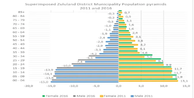
The municipality of eDumbe has the smallest population in the district, at 89 614 people, which is 10% of the total district population (see Figure 2 below). This trend continues in all local congregations of the district, which tends strongly towards Africans.
Socio-Economic Profile
Economic Activity
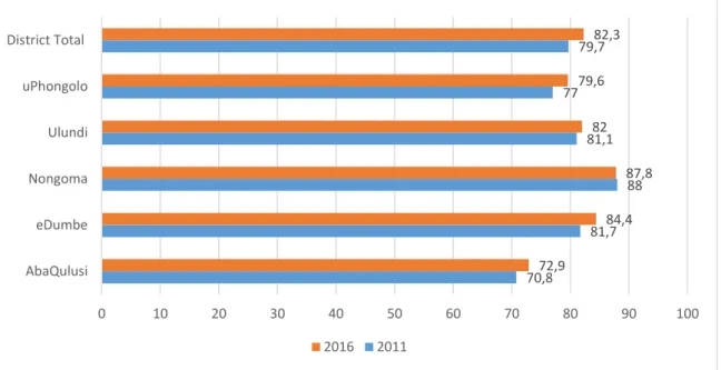
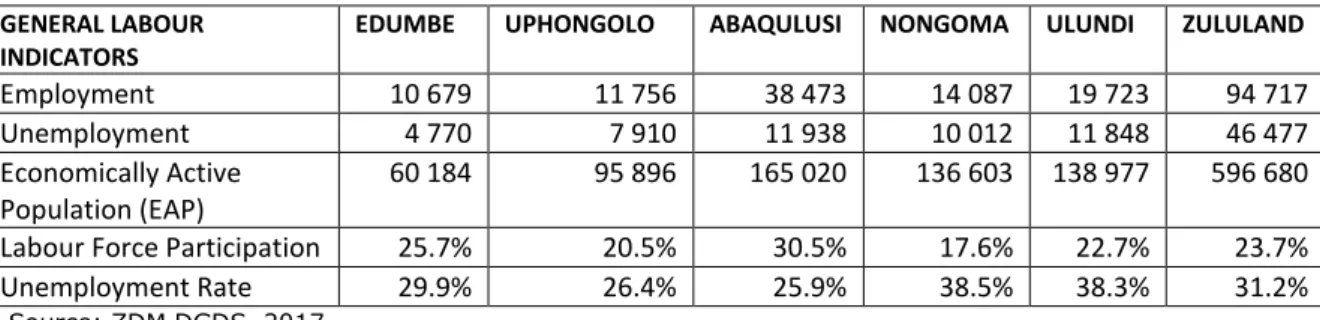
Unemployment Rate
Over the years, the most employment opportunities in the district have been in Abaqulusi and Ulundi LM. A worrying trend for all municipalities in Zululand is the increase in the burden of addiction between 2011 and 2016, especially given the unfavorable socio-economic conditions.
Education Profile
This means that one person in the working age group takes care of two persons in the non-working age group. The eDumbe, Nongoma and Ulundi LMs reported the highest number of people without education in the district, with.
Access to Basic Services and Service Backlogs
- Access to Water
- Access to electricity
- Access to sanitation
- Access to refuse Removal
- Access to Telecommunications
- Summary of service delivery
The proportion of households with access to a radio has remained fairly stable over the years, with relatively high levels of access. There are a large number of households in Zululand County that do not have access to internet services.

Spatial Analysis
- Spatial Structure
- Settlement Pattern
- Settlement Densities
- Land Use Pattern
- Land Reform and Ownership
The settlement pattern in ZDM resembles the situation in many parts of KZN province. Commercial agriculture is one of the main economic activities in ZDM and consumes large parts of the district's land.
Environmental Considerations
- Landscape Overview (Terrain)
- Vegetation, Plant and Animal Species
- Protected Areas
- Terrestrial Ecosystems and Biodiversity Priority Areas
- Critical Biodiversity Areas
- Ecological Support Areas
- Wetlands
- River Catchments
- Climate
- Agricultural Potential
In the upper reaches of the watershed, there is approximately 100 km2 of commercial forest (or 3% of land cover) and 20 km2 of non-native vegetation (or less than 1% of land cover). Irreplaceable land exists in the Western Highlands of the district, eDumbe Municipality and Abaqulusi Municipality.
Disaster Management
- Disaster Management Plan
- Institutional Capacity
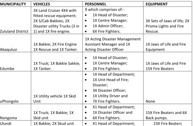
- Resources and Equipment
- Risk Assessment
- Risk Reduction and Prevention
- Response and Recovery
- Information Management And Communication
- Public Awareness
The disaster risk management function and Disaster Management Center (DMC) in the ZDM is under the Corporate Services Division. Zululand District Disaster Advisory Committee is fully functional and is in terms of the Disaster Management Act No.
Municipal Transformation and Institutional Development
- Gazetted Powers and Functions
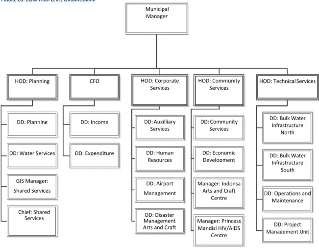
- Administrative Capacity (Approved Organogram)
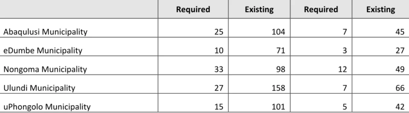
- Staff Complement and Vacancy rate
- Employment Equity
- Skills Development and Capacity Building
- Human Resource Management
Tight integration of other systems is key to project management system implementation. This is captured in Manzi and depending on the nature of the case is shared with the relevant official.
Basic Service Delivery
- Water Services Authority
- Water
- Sanitation
- Electricity
- Refuse removal and disposal
- Housing (Human Settlement)
- Transport Infrastructure
This represents the situation before the construction of the out-of-channel storage dam on the Kwa Nkweme River. The table below presents a summary of the length of paved and unpaved road in the Zululand District Municipality.

Economic Analysis
- LED Function
- Size and Structure of the ZDM Economy
- Sector performance and contribution to GDP
- Economic Sectors
- Employment by Sectors
The Zululand District Municipality's Growth and Development Plan identifies Zululand as one of the poorest in the country. ZAC is the only anthracite coal mine in South Africa and prides itself on "the superior quality attributed to each product, which places it in a unique and advantageous position as a supplier of reductant3 to the metallurgical industry" (Zululand Anthracite Colliery, 2019).
Social Development
- Community Facilities and Services
- Vulnerable Groups
- Nation Building and Social Cohesion
- Care and Support Programmes
- Social Development Indicators
One of the social development IDP objectives of the ZDM is the social upliftment of communities in the ZDM. Like many other districts, the majority of the population in the Zululand District Municipality is community (about 80%) and this means a small income base.
Municipal Financial Viability and Management Analysis
- Income and Expenditure
- Financial Viability/Sustainability
- Financial Management
- Free Basic Services and Indigent Register
A municipality's ability to continue as a going concern depends on a number of factors. In the 18/19 financial year, the municipality's financial system was upgraded to Solar, which is more compliant with MSCOA.
Good Governance
- Political Governance
- Batho Pele Principles
- Operation Sukuma Sakhe
- Intergovernmental Relations (IGR)
- Public Participation
- IDP and Budget Preparation
- Audit Function
- Management Systems
- Land Use Management and Development Planning
The majority of the population in Zululand district municipality is poor (about 53%), and this means a small income base. It also allows for horizontal and vertical adaptation of government programs to ZDM's and the local municipalities.
STRATEGIC ANALYSIS
Trends and Patterns
As such, large parts of the district reflect a sparse settlement typology typical of such an area. The Zululand District Municipality contains some of the most important environmental assets in the province, and these have a direct impact on the rural areas of the district.
KEY DEVELOPMENT CHALLENGES
This includes lack of garbage collection service in rural settlements, water deprivation, sanitation backlog and poor access to reliable energy sources. In some of these settlements, the population is declining as people move to areas where the public is more accessible.
SWOT Analysis
ZDM has formulated its long-term development strategy within the framework of a number of local authority legislation; national development agenda; and the provincial development program. The strategy responds directly to the development issues facing the ZDM and seeks to reposition the district to cease opportunities presented by the external environment, defend the gains of recent years and withstand challenges that may arise at any given time.
Human and Community Development • To develop and empower youth, gender diversity and people with disabilities – through sporting and cultural events. Strategic Infrastructure • To progressively provide cost effective, reliable and good quality water services to all potential consumers in the district.
Spatial Perspective
- Spatial Vision of the ZDM
- Development Nodes
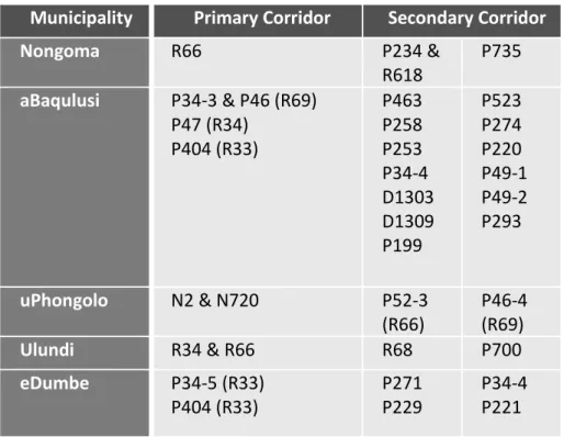
- Development Corridors
- Spatial Strategic Intervention Areas
- High Value Agricultural Land
The location of the different levels of agricultural potential is depicted in the image below. Mining activities specifically threaten the areas south of the Hlobane Coronation area where the highest agricultural potential for the district is located.
Strategic Environmental Management Plan
Therefore, sustainable agricultural development is critical for resources important for food security, livelihoods, economic activity and job creation. This zone was established to promote sustainable agricultural development with the aim of increasing the contribution of the agricultural sector to the economy; to protect virgin areas of agricultural potential from loss to other types of development or decline, and to conserve natural resources.
Five Year Implementation plan
Basic Service Delivery and Infrastructure
Local Economic Development
Social Development
Annual Operational Plan
Basic Service Delivery & Infrastructure
Local Economic & Social Development
Municipal Financial Viability & Management
Good Governance & Public Participation
Municipal Transformation & Organizational Development
Capital Investment Framework
General Projects
Local Economic Development Projects
Catalytic Projects
Rural Development and Land Reform Projects
Department of Human Settlement
Ulundi Local Municipality
ZDM Water and Sanitation
Zululand District MTEF Allocation 2020/21 to 2022/23
Medium Term Expenditure Framework
Grant Funding
Revenue by Source
Operating Expenditure
Zululand District Municipality
Ulundi is the current seat of Zululand Municipality and the former seat of the KZN government. Low-density settlements are unevenly distributed in different parts of the district with a higher concentration in the local municipalities of Nongoma and Ulundi.
Land Cover
Protected Areas
Land Reform
The demarcation and appropriate management of the best remaining plots within Zululand District Municipality is therefore crucial for the conservation of these vegetation types in KZN. Fragmented moist upland grasslands in the district are part of the Ekangala Grasslands Project, particularly upland areas near Vryheid and Ngome.
Conservation Areas
In addition to providing critical ecosystem goods and services, wetlands are also of great importance for biodiversity due to the various natural communities associated with them. Over 60% of South Africa's river flow originates from just 20% of the land.
Water Eco-system
The Pongola watersheds are characterized by large-scale forestation, estimated at 480 km2 (or 6% of the land cover) in the upper tributaries of Pongola and Bivane, and large-scale irrigation of about 200 km2 (or 2.5% of the land cover) in the W44 watersheds upstream of the Pongolapoort Dam. The higher temperatures occur in the eastern areas, while the western and interior areas are cooler.
Agricultural Potential
The disaster management center has a district disaster manager and disaster management officers per local municipality. One of the fundamental objectives of this campaign is to ensure the visibility of the District Disaster Management Center (DDMC) at the local level.
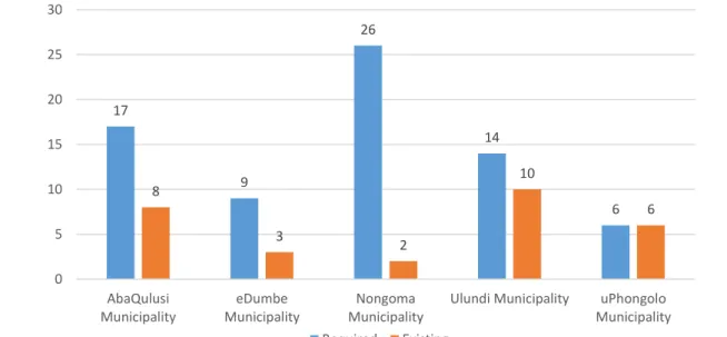
Water Backlog
After 2024, Mfolozi Bardhë's existing water resources infrastructure will need augmentation to meet projected water demands. After 2021, Mfolozi Bardhë's existing water resources infrastructure will need augmentation to meet projected water demands.

Sanitation Backlog
The sites located in the Enyathi and Coronation waste dumps have been abandoned as the waste is transported to Vryheid. The eMondlo landfill is located near a sensitive environment and human habitations, so it must be properly closed and rehabilitated.
Waste Disposal Sites
Ownership of Ulundi Airport was transferred from the Prime Minister's Office to the Zululand District Municipality in April 2007. However, like the country and the province, the economy of the district is driven by the service sector.
Tourism Sites
However, mining activities in the district declined in the mid-1990s, mainly due to the closure of mines due to the open market in coal mining and agriculture. Mine rehabilitation has not been done for a number of mines in the area, which have the potential to cause leaching as well as create conditions for standing water accumulation which, if used by humans, will result in health impacts.
Areas with Mineral Deposits in the ZDM
Business and commercial activities tend to be concentrated in existing cities, away from the majority of the population. Operate and maintain a viable regional airport that contributes to the growth and development of the district.
ZDM Spatial Vision
The relative importance of development hubs is a reflection of an area's economic development potential and the range of services to be provided. The natural features of uPhongolo allow further ecotourism in the highly sensitive areas adjacent to the Pongola Poort Dam and the areas between the R69 and the N2.
Development Nodes
One of the main structural elements that determine the existing and future concentration of development, activities and investments in a. The map on the back page shows the areas where strategic objectives from the KwaZulu-Natal Provincial Growth and Development Strategy urgently need to be addressed to enable the county's overall economic growth.
Job Creation
Agricultural potential that can be developed is located in the municipalities of uPhongolo, Abaqulusi and eDumbe LM, where conditions are. Areas within the Abaqulusi LM (Vryheid Hlobane and Emondlo), eDumbe LM (Paul Pietersburg, eDumbe & Bilanyoni) and uPhongolo LM (Pongola, Godlwayo & . Belgrade) have economic potential that can only be exploited if the skills of the communities are developed to allow them to participate in the economy.
Human Resource Development
The upper part of the Map outlines the areas of intervention for early childhood development and skills development that need to be improved to help economic growth within the areas. Apart from the identified areas highlighted in blue, nodal areas as well as all new housing projects should be targeted for initiatives related to Human and Community Development.
Human and Community Development
The map above presents the most important connections within the Municipality, which is critical for access to economic zones and the movement of economic goods. Communication technology is critical to ensure competitiveness with economic competitors and to ensure access to global markets.
Strategic Infrastructure
The transport network is the only way to transport economic goods and so an integrated system is required to enable a fully functioning district. The map below shows the areas that have previously been identified as environmentally sensitive and are important for maintaining ecological and biodiversity integrity.
Response to Climate Change
These areas consist of the environmentally sensitive areas identified on the informant maps as well as the environmental corridors identified by the KZN PGDS and Spatial Development Framework. The highest potential agricultural land is located in the northern half of the district and more specifically in the more even slope areas of uPhongolo, Abaqulusi and eDumbe Local Municipalities.
High Value Agricultural Land
The aim is to identify areas with agricultural potential in order to expand the agricultural sector. Agricultural activities within the Zululand district can be grouped into four distinct areas relating to Arable Agriculture, Forestry, Grazing Activities and Subsistence Agriculture.
Preservation of Agricultural Land
The southern parts of the Municipality are characterized by secondary Agricultural land which coincides with the subsistence agricultural activities. The Bio-Resource Information Unit of the National Department of Agriculture Forestry and Fisheries provides guidelines in this regard.
ZDM Municipal Spatial Development Framework
Environmental Sensitivity
Environmental Management Zones
Zone 1: Agricultural development zone
The agricultural sector is important to the local economy and job creation in the area. Existing cultivated areas were found to overlap with areas previously identified as having different characteristics, such as highly sensitive areas or urban areas.
Zone 2: Rural conservation zone
Zone 3: Controlled development zone
Rural Development Zone
Zone 5: Urban conservation zone
Zone 6: Urban development zone