The use of scientific and indigenous knowledge in agricultural land evaluation and soil fertility studies of Ezigeni and Ogagwini villages in
KwaZulu-Natal, South Africa
Nkosinomusa Nomfundo Buthelezi
Submitted in fulfilment of the academic requirements for the degree of Master of Science in the Discipline of Soil Science
School of Environmental Sciences Faculty of Science and Agriculture
University of KwaZulu-Natal Pietermaritzburg
March 2010
DECLARATION
I hereby certify that the research reported in this thesis is the result of my own investigation, except as acknowledged herein, and that it has not been submitted for a degree at any other university.
Signed: Date:
Nkosinomusa N. Buthelezi
Signed: Date:
Professor J.C. Hughes (supervisor)
Signed: Date:
Professor A.T. Modi (co-supervisor)
ABSTRACT
In the past, the indigenous knowledge of soils of small-scale farmers in South Africa has been largely ignored in scientific research. Hence the use of scientific approaches to land evaluation has often failed to improve land use in rural areas where understanding of the prescriptive scientific logic is lacking. Despite this, it is clear that local people and small- scale farmers have knowledge of their lands based on soil and land characteristics that remain largely unknown to the scientific community. It is therefore important for researchers to understand farmers’ knowledge of soil classification and management.
To address this issue, a study was conducted in the uMbumbulu area of KwaZulu-Natal to investigate the use of indigenous knowledge as well as farmers’ perceptions and assessments of soil fertility. A preliminary questionnaire was designed to explore indigenous knowledge in a group interview that was conducted prior to the study. Another questionnaire was used to elicit indigenous knowledge from 59 randomly chosen homesteads representative of the population of Ezigeni and Ogagwini villages. Six homesteads were chosen for further detailed information on the cropping history, knowledge specific to the cultivated lands, detailed soil description and fertility. Soil samples were taken from these homesteads under different land uses (taro, fallow, veld and vegetable) at 0-30 and 30-60 cm depth for laboratory analysis. This was done to determine the effect of land use on soil physical and chemical properties and soil microbial activity. For scientific evaluation a general purpose free soil survey was conducted to produce land capability and suitability maps.
Farmers identified ten soil types using soil morphological characteristics, mainly soil colour and texture. These soil properties were also used in the farmers’ land suitability assessment.
In addition, slope position, natural vegetation and village location were used to indicate land suitability. The amount of topsoil was also used in land evaluation. However, slope position was considered the most important factor as it affects the pattern of soils and hence their suitability. Soils on the footslope were considered more suitable for crops than those found on the midslope and upslope. The yield difference observed between villages, which were higher in Ogagwini than Ezigeni, was also used as a criterion for evaluation. Farmers attributed these yield differences for various crops to the effect of soil type on productivity. In support, scientific evaluation found that Ezigeni village had a number of soils with a heavy
textured, pedocutanic B horizon and hence a relatively shallow effective rooting depth.
Moreover, the Ezigeni village land suitability was limited in places by poor drainage and stoniness. These limitations were rarely found for the Ogagwini village soils.
Farmers had a total of six comprehensive and well defined soil fertility indicators, namely crop yield, crop appearance, natural vegetation, soil texture, soil colour and presence of mesofauna. Results showed that farmers’ fertility perceptions are more holistic than those of researchers. However, despite this, their assessment correlated with soil analysis. There was a close relationship between scientific and indigenous suitability evaluation for three commonly cultivated crops (taro, maize and dry beans). This was further substantiated by yield measurements which were significantly higher for Ogagwini as rated by both farmers and scientific evaluation as the more suitable. The significant agreements between the scientific and indigenous approaches imply that there are fundamental similarities between them. Recognizing this and subsequently integrating the two approaches will produce land use plans relevant and profitable for both small-scale farmers and scientists.
PREFACE
The experimental work described in this thesis was carried out in the School of Environmental Sciences, University of KwaZulu-Natal, Pietermaritzburg, from July 2008 to November 2009, under the supervision of Professor Jeffrey C. Hughes and Professor Albert T. Modi.
This study represents original work by the author and has not otherwise been submitted in any form for any degree or diploma to any tertiary institution. Where use has been made of the work of others it is duly acknowledged in the text.
DECLARATION – PLAGIARISM
I, Nkosinomusa Nomfundo Buthelezi, declare that:
1. The research reported in this thesis, except where otherwise indicated, is my original research.
2. This thesis has not been submitted for any degree or examination at any other university.
3. This thesis does not contain other persons’ data, pictures, graphs or other information, unless specifically acknowledged as being sourced from other persons.
4. This thesis does not contain other persons' writing, unless specifically acknowledged as being sourced from other researchers. Where other written sources have been quoted, then:
a. Their words have been re-written but the general information attributed to them has been referenced
b. Where their exact words have been used, then their writing has been placed in italics and inside quotation marks, and referenced.
5. This thesis does not contain text, graphics or tables copied and pasted from the Internet, unless specifically acknowledged, and the source being detailed in the thesis and in the References section.
Signed: ………
Date: ………..
ACKNOWLEDGEMENTS
I would like to extend my gratitude to the following:
Firstly, God Almighty for helping me realize my potential and for always coming through for me.
Professor Jeff Hughes for constantly believing in me, guidance, encouragement, and for academic assistance towards the completion of the study.
Professor Albert Modi for help with the project design, advice and soil survey.
South Africa Netherlands Research Programme on Alternatives in Development under project 05/32 entitled: “The social agronomy of compound agriculture: A case study of the dynamics of commercialization”, and the National Research Foundation, Pretoria for funding the project.
Ezemvelo Farmers Organisation members for their availability for the interviews.
Victor Bangamwabo for help with digitizing the maps.
Dr. Dorothea Smith for help with the microbial activity analysis.
Tad Dorasamy for assistance and advice with laboratory analysis.
Jo Buthelezi, Ayanda Mthalane, Simphiwe Ngcobo and Vusi Mbanjwa for help with field data collection.
Dr. Shaun Ramroop for statistical advice.
Charity Maphumulo, Karen Caister and Ncebo Zulu for their help in the interviews.
Phesheya Dlamini for help and advice on various aspects of the study.
Lastly, my beautiful daughter, Siphokazi Dlamini, for the inspiration to finish this thesis.
TABLE OF CONTENTS
DECLARATION ………. i
ABSTRACT ……… ii
PREFACE ………iv
DECLARATION – PLAGIARISM ………. v
ACKNOWLEDGEMENTS ………. vi
LIST OF TABLES ……… x
LIST OF FIGURES ……… xi
LIST OF PLATES ………. xii
LIST OF APPENDICES ……… xiii
CHAPTER ONE INTRODUCTION ……… 1
CHAPTER TWO SCIENTIFIC AND INDIGENOUS LAND EVALUATION AND MANAGEMENT OF SOILS ………4
2.1 Indigenous knowledge ……….. 4
2.1.1 What is indigenous knowledge? ……… 4
2.1.2 Indigenous soil classification and land evaluation ……… 6
2.1.3 Indigenous soil management ……….……. 9
2.1.3.1 Soil fertility ……… 9
2.1.3.2 Indigenous land use practices ……….. 10
(a) Shifting cultivation, crop rotation and intercropping ……….. 10
(b) Nutrient supply from inorganic and organic sources ……….. 13
2.1.4 Indigenous soil and water conservation ………. 13
2.2 Scientific knowledge ……….. 15
2.2.1 Scientific land evaluation ……… 16
2.3 Soil fertility: Historical perspective ……….…… 17
2.4 Integrating indigenous and scientific knowledge ………... 19
2.5 Conclusion ……….. 22
CHAPTER THREE MATERIALS AND METHODS ……… 23
3.1 Background ……… 23
3.2 Choice of study area ……… 24
3.3 Indigenous land evaluation ……… 24
3.3.1 Household interviews ………. 24
3.4 Scientific land evaluation ……….………… 25
3.4.1 Soil survey and mapping ……… 25
3.4.2 Soil sampling and analysis ………. 26
3.4.3 Statistical analysis ………...… 26
3.5 Comparison methodology ……….... 27
CHAPTER FOUR RESULTS AND DISCUSSION ……….…. 28
4.1 Household characteristics ……… 28
4.2 Indigenous soil management ……… 29
4.2.1 Indigenous soil classification ……….………... 30
4.2.2 Land suitability assessment ……… 31
4.3 Scientific land suitability assessment ……….. 34
4.4 Farmer soil fertility indicators ………. 35
4.5 Soil fertility analysis ………. 37
4.5.1 Plant nutrients and soil pH ………. 37
4.5.2 Soil organic carbon ………. 38
4.5.3 Soil particle size distribution ……….. 38
4.5.4 Soil microbial activity ………. 41
4.6 Yield ………... 42
CHAPTER FIVE CONCLUSIONS ……….…. 44
REFERENCES ………. 47
APPENDICES ……….. 61
LIST OF TABLES
Table 2.1. Ethnolinguistic terminology used in Zoyatlán, Mexico for diagnostic soil features and designation of the distinct properties of topsoil (modified from
Cervantes-Gutiérrez et al., 2005) ... 7
Table 2.2. Organic carbon, pH and available nutrients after monoculture and intercropping in western India (modified from Manna and Singh, 2001) ………. 12
Table 4.1. Household characteristics of EFO memebres interviewed from Ezigeni
and Ogagwini villages ……… 28
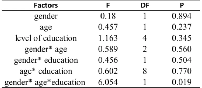
Table 4.2. Multivariate analysis showing the significance of age, gender and education level and their interactions on farmers’ indigenous knowledge in Ezigeni and
Ogagwini villages (n = 59) ………. 29
Table 4.3. Local soil taxonomy used by farmers of Ezigeni and Ogagwini villages (n =59)..31
Table 4.4. Crop suitability according to Ezigeni and Ogagwini farmers (n = 59) …………. 33
Table 4.5a. Soil chemical properties and particle size distribution of the A
horizon of soils from Ezigeni village ……….…. 39
Table 4.5b. Soil chemical properties and particle size distribution of the B
horizon of soils from Ezigeni village ……….. 39
Table 4.6a. Soil chemical properties and particle size distribution of the A
horizon of soils from Ogagwini village ……….. 40
Table 4.6b. Soil chemical properties and particle size distribution of the B
horizon of soils from Ogagwini village ……….. 40
LIST OF FIGURES
Figure 2.1. Schematic representation of the comparison between scientific and local
knowledge systems (Cook et al., 1998 cited by Barrios and Trejo, 2003).………. 21
Figure 3.1. The location of Ezigeni and Ogagwini villages in KwaZulu-Natal ….………... 23
Figure 4.1. Factors considered for land suitability assessment (‘natural…’ refers to
natural vegetation) by farmers of Ezigeni and Ogagwini villages ……….……….32
Figure 4.2. Local indicators identified by farmers in responses to the questionnaire
Appendix 1) for fertility assessment of soils in Ezigeni and Ogagwini villages ……… 35
Figure 4.3. The effect of land use on microbial activity in A and B horizons of soils in Ezigeni and Ogagwini villages………. 41
Figure 4.4. Means for crop yields across locations (p< 0.05). B - beans; M – maize;
T – taro; E – Ezigeni ; O – Ogagwini... 42 Figure 4.5. Means for yields of beans, maize and taro across homesteads (p<0.05) ……… 43
LIST OF PLATES
Plate 2.1. Techniques used by local people of Okhombe, KwaZulu-Natal to decrease the rate of soil erosion (a) stone packs and (b) indigenous grass (from Everson et al., 2007)…...15
Plate 4.1. Mixed cropping practice (beans, maize and taro) at Ezigeni village………... 29
LIST OF APPENDICES
Appendix 1. Questionnaires...62
Appendix 1 (a). Preliminary questionnaire... 62
Appendix 1 (b). General survey questionnaire (Zulu version)...64
Appendix 1 (c). General survey questionnaire (English version)………... 67
Appendix 2. Detailed survey questionnaire……… 69
Appendix 3. Farmers’ responses to the detailed survey questionnaire………70
Appendix 4. Farmers’ responses to the preliminary questionnaire………. 72
Appendix 5. Soil map of Ezigeni village... 74
Appendix 6. Land capability map for Ezigeni and Ogagwini villages………75
Appendix 7. Land suitability map for dry bean production in Ezigeni village………... 76
Appendix 8. Land suitability map for taro production in Ezigeni village………... 77
Appendix 9. Land suitability map for maize production in Ezigeni village………. 78
Appendix 10. Land suitability map for dry bean production in Ogagwini village………….. 79
Appendix 11. Land suitability map for taro production in Ogagwini village……… 80
Appendix 12. Land suitability map for maize production in the Ogagwini village………... 81
Appendix 13. Soil map of Ogagwini village... 82
CHAPTER ONE INTRODUCTION
The exponential increase in world population density and the introduction of land reforms have caused an increase in agricultural land degradation, often through overgrazing and agricultural mismanagement. This increase has caused a significant decrease in the arable land available for agriculture and increased use of energy, irrigation overuse and high fertilizer application (Apai and Navanugraha, 2004). On the other hand, economic recession has led to a large increase in agricultural land use, especially in rural areas, because people cannot afford to buy food. As a result, the increased pressure on the land has caused serious concerns for long-term agricultural sustainability and food security.
To recover and secure agricultural sustainability in both subsistence and commercial farming, there is a need to reassess our land evaluation systems. Scientists should consider both the direct methods of an indigenous approach and the indirect methods of the scientific approach.
The latter evaluates the land based on the soil and site properties that can influence a particular land use, while the former evaluates by trial and error where the evaluator grows the crop or makes a construction and observes the response (McRae and Burnham, 1981).
Krupenikov (1992) recorded that the direct methods have been used since the Stone Age and hence are of significant value to the local people. This was corroborated by Sandor et al.
(2006) who mentioned that these methods employ the knowledge that has been accumulated by local people and passed down over generations from their interaction with the environment. Numerous studies have investigated the potential of integrating the indigenous knowledge system with the scientific system for improved agricultural sustainability (Payton et al., 2003; Oudwater and Martin, 2003; Adedipe et al., 2004; Gowing et al., 2004;
Cervantes-Gutiérrez et al., 2005). It is hence likely that they will have a positive impact when included in land evaluation methods.
Land evaluation involves land use planning which informs all decision making done for the sustainable use of land resources (Gowing et al., 2004). This process can be carried out in three ways namely suitability, capability and value (McRae and Burnham, 1981). However, the method most used for agricultural purposes is a suitability study which evaluates the land for a defined use or practice (McRae and Burnham, 1981). Unfortunately, land evaluation
processes have been done mainly through soil surveys which farmers may not fully understand and which exclude the social and cultural aspects. Brinkman and Smyth (1972) reported that these factors are essential when conducting and interpreting land evaluation because it allows people to contribute to land use planning. They further stated that the concept of land can be closely related to that of a cultural ecosystem which includes the influence of man on land attributes. Therefore, understanding and incorporating indigenous knowledge and indigenous farming and management practices in land evaluation will ensure proper land use and resource management in rural areas.
A high production demand requires an increase in agricultural productivity. To achieve such high productivity, farming practices implemented by both scientific and indigenous approaches should ensure good soil fertility management. Soil fertility is the capacity of the soil to support the population of crops above-ground and is thus essential to sustainable agriculture as well as food security (Watson et al., 2002). The implemented land management practices should not only improve soil fertility but also ensure sustainability to prevent resource base degradation. The importance of soil fertility has led to the development of suitable management strategies which provide sustained and profitable production such as crop rotation, shifting cultivation and intercropping (Manna and Singh, 2001). These practices have been utilized in both scientific and indigenous approaches as means of soil conservation and increasing soil fertility for many centuries. They have been observed to have beneficial effects on nutrient availability and soil biological, physical and chemical properties.
However, agricultural intensification, mainly following the scientific approach, has reduced crop diversity through monocropping often resulting in low soil fertility status (Apai and Navanugraha, 2004). In the indigenous approach, intensified agriculture has caused farmers to decrease the fallow period also causing a decrease in soil fertility (McAllister, 1992). The decreased soil fertility observed under monoculture is a result of nutrient and water depletion due to a constant demand for the same nutrients over a long period of time, as well as an increase in the pathogen population (Turkington et al., 2004). Sound management strategies can be derived from information provided by soil fertility analysis. Soil tests assist in fertilizer recommendation hence preventing under or over application of fertilizers.
According to Beegle (1995) the increase in fertilizer application rate has led to a decreased plant response. This consequently causes the unavailability of some nutrients due to nutrient
imbalance. Soil acidity is another major concern for soil fertility management because low soil pH limits the availability of most plant nutrients. High application of fertilizers, especially nitrogen fertilizers, can elevate soil acidity and therefore result in a similar effect on nutrient availability. Even though acidic soils can be ameliorated through the application of lime there are high costs involved, especially for commercial farmers who are cultivating very large land areas. The use of low input systems in the indigenous approach, mainly practiced in rural areas, has shown high productivity with minimal management costs (Rajasekeran, 1993; Barrera-Bassols and Zinck, 2003a).
It is unfortunate, however, that there is almost no literature referring to indigenous knowledge of soils in South Africa. As mentioned previously such ignorance has resulted in the use of scientific approaches to land evaluation. These have often failed to improve land use especially in rural areas where prescriptive logic is lacking. Despite this, it is clear that local people have knowledge of their soils and have been using it for generations. This research is therefore aimed to gain a preliminary understanding of a much undervalued aspect of soil science that will allow further sustainability of our soil resource. The study focuses on two villages in KwaZulu-Natal, Ezigeni and Ogagwini, and aims to:
(a) explore indigenous and scientific knowledge systems in terms of land evaluation;
(b) compare indigenous and scientific land evaluation; and
(c) test farmer fertility management and assessment systems using scientific methods.
CHAPTER TWO
SCIENTIFIC AND INDIGENOUS LAND EVALUATION AND MANAGEMENT OF SOILS
2.1 Indigenous knowledge
2.1.1 What is indigenous knowledge?
Indigenous knowledge refers to the knowledge that has been accumulated by local people over a number of generations through their direct interactions with the land and environment (Sandor et al., 2006). This knowledge has been studied since the nineteenth century following the perceived failure of scientific methodologies and interventions to improve subsistence farming. Scientists have since recognized the value and potential of farmers’ knowledge to improve agricultural development. To develop research methodologies aimed at collecting and documenting indigenous soil knowledge, a new discipline termed ‘ethnopedology’ was introduced. Ethnopedology is a “hybrid discipline structured from the combination of natural and social sciences” (Barrera-Bassols and Zinck, 2003a). The documented knowledge includes local perceptions of soil classification, soil use and management (Sandor et al., 2006), which are used to increase the relevance of scientific interventions as well as their adoption by farmers (Sillitoe, 1998). The incorporation of indigenous knowledge brings the
‘locally informed perspective’ into development strategies hence increasing their potential in small-scale, subsistence farming (Crevello, 2004).
The long-term interaction of local people with their land and environment led to the establishment of a historically and culturally-constituted indigenous knowledge (Altieri and Trujillo, 1987; Purcell, 1998; Sandor et al., 2006). The survival of indigenous knowledge through adverse field conditions for many centuries has proven it to be time-tested knowledge compared to the more recent scientific knowledge (Norgaard, 1984; Purcell, 1998). However, the dynamic nature and oral transmission of indigenous knowledge (Beckford and Barker, 2007) makes it more vulnerable to change with each new generation.
The ‘ecological rationale’ of indigenous knowledge allows for the implementation of ecologically correct systems for the partitioning of natural resources (Alteiri and Trujillo 1987). Erkossa and Ayele (2003) refer to indigenous knowledge as an insight that the local people have on their natural and social environment which they use to adapt to their local context. This shows that this is not just merely knowledge but it is a skill and heritage of
everyday life (Sillitoe, 1998) that is used as a basis for decision making not only in agriculture but also in human and animal health (Beckford and Barker, 2007). Indigenous knowledge has subsequently become a key aspect of local communities (Ogen, 2006).
Purcell (1998) stated that culture is essential to the existence of indigenous knowledge.
Indigenous knowledge therefore becomes location specific and dependent on social customs, ethnicity, age, gender and wealth as well as interactions between and within communities (WinklerPrins and Sandor, 2003). For example, Birmingham (2003) found that a farmer’s knowledge followed a land tenure pattern i.e., the farmer was more familiar with the land belonging to him. In addition, Sillitoe (1998) mentioned that such dependency limits the accessibility and potential use of indigenous knowledge.
Engel-Di Mauro (2003) studied the effects of gender relations and social standing on local soil knowledge and management in SW Hungary and he found that gender had a direct influence on soil classification and soil management. Low soil pH and macronutrient levels were measured in male-controlled cash crops and very high amounts of phosphorus on female-controlled subsistence plots. For soil classification, women used general descriptions while men had much more specific knowledge because of their exposure to education and training. This showed a direct relationship between gender and soil knowledge and management. From the results, Engel-Di Mauro (2003) then recommended further research on the effect of social relations on soil and soil dynamics.
The effect of age was shown by Birmingham (2003) in a study on local knowledge of soils in Ivory Coast. He found that adults had a broader and more detailed understanding of indigenous knowledge than the youth. The reason for this variation as given by farmers was that young people retain information only when it is written down. This shows the effect of modern training and education on the conservation, relevance and value of indigenous knowledge (Habarurema and Steiner, 1997). A study by Akullo (2007) in Uganda also outlined that education and training have prejudiced peoples’ outlook on indigenous knowledge.
Another limitation to the use of indigenous knowledge is the question of its reliability and long-term sustainability. Bellon (1995) argued that there is no adaptive or direct functional link between knowledge and management. He further mentioned that for indigenous
knowledge to contribute to long-term agricultural sustainability there should be an established functional relationship between specific knowledge and a particular management practice. Developing research methodologies to address this problem still remains a challenge.
The loss of indigenous knowledge through generation succession and introduction of new crop varieties has caused much uncertainty and doubt for many subsistence farmers over the years. Alteiri and Trujillo (1987) noted that the replacement of indigenous crop varieties with new hybrids and adoption of modern technologies limit the relevance of indigenous knowledge. This results in the loss of knowledge of traditional cropping patterns and management practices. However, despite all these limitations, scientific research has shown the relevance and significance of indigenous knowledge (Richards, 1985; Sillitoe, 1998;
Payton et al., 2003; Sandor et al., 2006; Akullo, 2007; Dlamini, 2007; He et al., 2007). It is therefore important to ensure the continued survival of indigenous knowledge.
Modification of indigenous knowledge to fit the scientific approach has caused much degradation of such knowledge. To counteract this, recent studies have moved towards integrating indigenous knowledge with scientific knowledge to achieve an efficient system understood by both farmers and scientists (Habarurema and Steiner, 1997; WinklerPrins, 1999; Cools et al., 2003; Gowing et al., 2004). Such integration will guarantee the conservation of indigenous knowledge as well as its impact on long-term sustainability.
2.1.2 Indigenous soil classification and land evaluation
The increasing value of indigenous soil knowledge to agricultural sustainability has resulted in the documentation of farmers’ knowledge so as to understand how they perceive and classify their soils (Shrestha et al., 2004). Niemeijer and Mazzucato (2003) mentioned that this indigenous soil knowledge forms a benchmark for communication not only between farmers but also between soil scientists, development workers and extension workers when compared to scientific classifications such as FAO, USDA Soil Taxonomy and French soil classifications. The integrative nature of indigenous knowledge is reflected in local classification systems which describe soils as a mixture of properties which are then combined and modified to build up descriptive classes (Sillitoe, 1998).
Indigenous soil classification uses physical and perceptual dimensions (Ettema, 1994;
Talawar and Rhoades, 1998). Cervantes-Gutiérrez et al. (2005) simplified this further and said local people use their knowledge to classify soils according to appearance, characteristics and productivity. Local soil classification is based on day-to-day surface observations which provide a true reflection of reality that are thus more reliable and viable for land use (Sillitoe, 1998; Eriksen and Ardón, 2003). Although this system does not consider soil genesis, it does consider the factors that influence land evaluation such as topography, microclimate and vegetation (Sillitoe, 1998).
The physical properties predominantly used by farmers are soil colour and texture and they are considered as the basis of indigenous soil classification (Barrera-Bassols and Zinck, 2003a). For example, farmers in Niger perceive black soils as the most fertile and heavier in texture and hence less susceptible to erosion, while light coloured soils are regarded as infertile and easily erodible. Furthermore, a study by Shrestha et al. (2004) showed that there are many other properties that farmers use to classify their soils. Among these are soil structure, consistency, workability, stone content, water infiltration, water retention and requirement as well as manure requirement. Cervantes-Gutiérrez et al. (2005) carried out a study in Mexico and illustrated how farmers use soil properties to classify their soils (Table 2.1). They found that farmers only use the topsoil properties which they combine to classify the soil into classes according to their agricultural suitability.
Table 2.1. Ethnolinguistic terminology used in Zoyatlán, Mexico for diagnostic soil features and designation of the distinct properties of topsoil (modified from Cervantes-Gutiérrez et al., 2005).
Soil type
Soil depth Soil colour Fertility Texture Consistency Water retention
Tlalcapochtic Deep Black High Not clayey, not sandy Loose Cold soil
"nibarrosa ni arenosa" "suelta" "suelo frio"
Tlaltezoquit Deep Black, brown High Clayey Very sticky Very cold soil
"barrosa" "muy pegajoso" "suelo muy frio"
Texalli Moderate to shallow Brown, red Good Sandy Very loose Hot soil
"arenosa" "muy suelta" "suelo caliente"
Tlalchiltic Moderate Red Low Not clayey, not sandy Loose Hot soil
"nibarrosa ni arenosa" "suelta" "suelo caliente"
Xalli Moderate to shallow Grey Low Sandy Very loose Cold soil
"arenosa" "muy suelta" "suelo frio"
Tlalnextli Deep White, ashy Very low Sandy to loam Loose Cold soil
"arenosa a suave" "suelta" "suelo frio"
Tepetatl Very thin Red, black Very low Sandy and clayey Loose to firm Not specified
"arenosa y barrosa" "suelta a dura"
Soil features Topsoil properties
The interpretation of the soil names given by farmers allows for almost a total quantification of the differentiating properties between soil classes which makes it valuable for agronomic classification. The study also demonstrated that farmers were well informed of the effect of environmental factors on soil characteristics as this knowledge guided their classification of soil into different types regarding quality, suitability and management.
In addition, Ettema (1994) found that farmers in Nigeria used taste and smell for agricultural evaluation. Taste was used to determine salinity and acidity. Smell was used to evaluate whether the soil is ‘good’ or ‘bad’. He also found that farmers used vegetation, suitability of the land for a certain crop production, degree of soil degradation and soil organisms. Farmers observed the growth of vegetation prior to planting as well the presence or absence of organisms to evaluate soil quality.
The indigenous evaluation approach is characterized by a descriptive classification so that the evaluation is not based on a clear soil and land classification (Talawar and Rhoades, 1998).
Furthermore, local soil classification systems are mainly focused on local soil taxonomies which do not adequately reflect the logic behind land use decisions thus limiting the use of local soil knowledge for sustainable development (Niemeijer and Mazzucato, 2003). Local soil classification is not only about local soil taxonomies but also reflects cultural and socioeconomic aspects (Barrera-Bassols and Zinck, 2003a). Unfortunately, the use of a comparative approach in most ethnological studies has excluded these basic elements of indigenous knowledge hence leaving out the practical implementation of local soil knowledge during the production process (Barrera-Bassols et al., 2006). This has confirmed the need to achieve an integrated methodological approach which will overcome the differences between the indigenous and modern systems (Sillitoe, 1998; Talawar and Rhoades, 1998; WinklerPrins, 1999). An integrated approach has been increasingly proposed as a relevant methodology as it recognizes the importance of the cultural context in understanding farmers’ knowledge of local soil classification (Barrera-Bassols and Zinck, 2003a).
Indigenous land evaluation plays a vital role in land use decision making and land management in rural areas (Zurayk et al., 2001). It enables subsistence farmers to match their production systems to soil types by providing fundamental information on soils as they appear on a landscape (Bacic et al., 2003). Low cost and relevant scales make traditional surveys used as part of indigenous land evaluation more easily accessible to farmers
(Habarurema and Steiner, 1997). Traditional surveys are available at large scale that gives detailed information at a village level hence giving more insight into land use and agricultural production (Niemeijer, 1995). This has given indigenous evaluation more value to the extent that it is used to supplement scientifically based systems and conventional mapping techniques (Krasilnikov and Tabor, 2003). Indigenous knowledge improves the relevance and accuracy of scientific surveys which otherwise would not benefit local people (Sillitoe, 1998).
2.1.3 Indigenous soil management
According to Talawar and Rhoades (1998) indigenous soil management is more concerned about managing natural processes (e.g. erosion, nitrification etc.) as indicated by the nature of visible agricultural variables than single components such as soil, plants and water resulting from these processes. Using indigenous knowledge, farmers have managed to develop sustainable land use management practices to improve subsistence farming.
2.1.3.1 Soil fertility
Soil fertility is the primary factor affecting agricultural sustainability. It is therefore necessary to explore how this factor is affected by land use management practices. A case study by Desbiez et al. (2004) showed that farmers prefer the term ‘field fitness’ rather than ‘soil fertility’ to describe soils’ ability to produce crops. They perceive soil fertility as a function of current and previous management regimes. This explains why soil fertility per se is not a primary factor in local evaluation (Greenland et al., 1994 cited by Talawar and Rhoades, 1998). In addition, Sillitoe (1998) mentioned that farmers treat soil fertility as a dynamic character of the soils which they improve through maximizing crop diversity. He further stated that farmers also take advantage of climatic and soil variations to enhance soil productivity and increase yields. As soil fertility indicators, farmers use soil colour, crop performance in terms of yield, vegetation and environmental factors. For example, soil colour provides a good measure of inherent soil fertility (Barrios and Trejo, 2003). Even so, crop production indicators used by farmers such as yield and crop appearance may not always be a true reflection of soil quality (Marenya et al., 2008). For example, high yield can be a result of favourable weather or improved seed (Marenya et al., 2008). Despite this, Payton et al.
(2003) still promote these indicators as a basis for environmental management as they provide accurate indications of environmental conditions. According to Fairhead and Scoones
(2005), farmers’ perception of soil fertility is both a soil and social criterion as it is based on moral, religious and mythical frameworks.
2.1.3.2 Indigenous land use practices
The main objective of indigenous land use practices is to increase agricultural diversity which plays a significant role in resource conservation and protection (Barrera-Bassols and Zinck, 2003a). These practices provide soil health hence maintaining soil fertility and productivity (Rajasekeran, 1993). Indigenous land use practices do not only ensure good management of the land but are also concerned with environmental management (Tikai and Kama, 2004).
(a) Shifting cultivation, crop rotation and intercropping
The use of these practices began when people were still hunter-gatherers and land management was mainly dependent on social dynamics. For example, the idea of fallowing is referred to in the Bible as people realized the benefit of “resting” the land (Leviticus 25: 3-5;
Reeves, 1997).
However, as the population increased and the land became scarce, people moved towards other cropping practises such as crop rotation, shifting cultivation and intercropping. Crop rotation involves the planting of different crops in a recurring sequence (Watson et al., 2002) while intercropping refers to the planting of different crops simultaneously (Richards, 1985).
Shifting cultivation has been defined by Dvořàk (1992) as the ‘alternation of periods of cropping with relatively long periods of fallow’. The beneficial effects of these practices are evident in soil physical, chemical and biological properties which influence soil fertility and determine the extent of soil degradation. A high degree of intra-specific and inter-specific crop diversity associated with these cropping systems reduces resource competition and enhances growth and productivity (Richards, 1985).
A case study conducted by Pestalozzi (2000) in the High Andes of Peru showed how people have manipulated the agricultural potential of this highly elevated area (4000 to 4500m above sea level) that has a low nutrient status to achieve relatively high yields through sectoral fallowing. In this management practice the field is left to lie fallow for nine years to allow for a high accumulation of biomass. Farmers mentioned that in fallowing vegetation has an essential role in restoring soil fertility by increasing organic matter accumulation. This was
confirmed by laboratory analyses which showed that soils had high nitrogen and phosphorus content (91 and 12.5 kg ha-1, respectively).
Fallowing was soon followed by the introduction of rotations with forage legumes, as population densities increased further (Reeves, 1997). A similar shift in land management was observed in the former Transkei (currently known as the Eastern Cape), South Africa in the study by McAllister (1992). He recorded that this increase in population pressure had a significant effect on agriculture from the 1940s. The benefit of rotations has also been observed when alfalfa is included. This crop is deep-rooted and is thus able to exploit nutrients from subsoil horizons which are then added to the upper layer when it decomposes (Gray, 1998). The legume-based rotation is an effective and a profitable way of restoring lost nutrients, mainly N, and improving soil properties especially under conventional farming (Belay, 2001).
The effect of legumes on nutrient availability is evident under intercropping. Intercropping legumes with cereals has been reported to better exploit mobile resources such as nitrates and soil moisture (Richards, 1985). Increase in soil moisture creates a favourable environment for microorganisms resulting in higher activity and biomass. In addition, intercropping has been observed to have a role in garden soil conservation (McAllister, 1992). Both intercropping and crop rotation assist in replacing the nutrients removed from the soil during harvest hence establishing a balanced nutrient cycling mechanism to prevent fertility depletion and increasing the sustainability of production systems (Grant et al., 2002). This is mainly through high mineralization of organic matter as a result of high microbial activity under these cropping systems (Haynes, 1984; Crevello, 2004). These cropping systems also provide diversity in agriculture which to a large extent prevents competition (Richards, 1985).
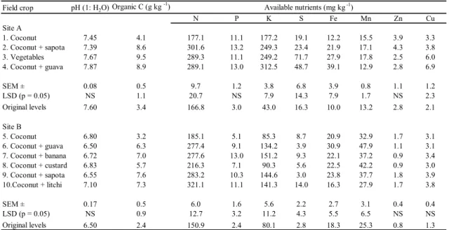
Manna and Singh (2001) conducted a long-term study (38 years) in western India to investigate the effect of intercropping on soil properties. The study compared intercropping and monocropping which is the dominant practice under intensive agriculture. Coconut and vegetable plots were planted under monoculture. Alternately coconut was intercropped with guava, sapota, banana, custard apple and litchi. The results showed a significant increase in mineral nutrients and soil organic carbon under intercropping as compared to monocropping (Table 2.2). This was attributed to high microbial activity and hence high mineralization of organic matter which results in the high release of nutrients.
For example under monoculture at site A available N was 177.1 mg kg-1 which was almost doubled under intercropping (301.6 mg kg-1). Organic carbon also increased from 4.1 g kg-1 under monoculture to 8.6 g kg-1 under intercropping. Biomass content was found to be 222 and 841 kg ha-1 under monocropping and intercropping, respectively. This is probably due to the residue that is incorporated into the soil over a long period of rotation resulting in the high organic matter content.
Table 2.2. Organic carbon, pH and available nutrients after monoculture and intercropping in western India (modified from Manna and Singh, 2001).
Field crop pH (1: H2O) Organic C (g kg -1)
N P K S Fe Mn Zn Cu
Site A
1. Coconut 7.45 4.1 177.1 11.1 177.2 19.1 12.2 15.5 3.9 3.3
2. Coconut + sapota 7.39 8.6 301.6 13.2 249.3 23.4 21.9 17.1 4.3 3.8
3. Vegetables 7.67 9.5 289.3 11.1 249.2 71.7 27.9 17.8 2.5 6.0
4. Coconut + guava 7.87 8.9 289.1 13.0 312.5 48.7 39.1 12.9 2.8 6.9
SEM ± 0.08 0.5 9.7 1.2 3.8 6.8 3.9 0.8 1.1 1.2
LSD (p = 0.05) NS 1.1 20.7 NS 7.9 14.3 7.9 1.7 NS 2.3
Original levels 7.60 3.4 166.8 3.0 43.0 16.3 10.0 13.2 2.8 2.1
Site B
5. Coconut 6.80 3.2 185.1 5.1 85.3 8.7 20.9 32.9 1.7 3.1
6. Coconut + guava 6.50 6.3 277.4 9.1 134.2 3.9 30.9 47.9 1.1 3.1
7. Coconut + banana 6.72 7.0 277.6 13.0 151.2 9.3 22.1 37.2 0.9 3.4
8. Coconut + custard 6.83 5.7 216.3 7.1 90.3 5.6 22.5 42.2 0.9 3.0
9. Coconut + sapota 6.55 7.6 283.2 10.3 144.6 3.0 23.8 37.7 1.8 3.9
10.Coconut + litchi 7.10 7.3 321.1 11.1 141.3 14.0 16.3 27.9 1.7 3.8
SEM ± 0.17 0.5 6.0 1.6 5.6 2.2 2.7 3.1 0.4 0.4
LSD (p = 0.05) NS 0.9 12.7 3.2 11.2 4.3 5.5 6.5 NS NS
Original levels 6.50 2.4 150.9 2.4 80.1 2.8 18.3 25.3 0.8 1.3
Available nutrients (mg kg -1)
The effect of the above-mentioned indigenous cropping systems is not only on the management of soil properties but also on weed, pest and disease management. When these cropping systems are employed they act as a defence against the build-up of disease-causing organisms (Gray, 1998) and are important for weed management (Reznicek and Jost, 1998).
Under intercropping, if the intercrops are effective and competitive, they can discourage weed growth by rapid establishment thereby overshadowing weeds (Richards, 1985).
Intercrops can also fight weeds through allelopathy (i.e., releasing harmful organic substances to prevent weeds from growing close to them). Rotations allow for the control of parasitic organisms by changing their host as the crops are changed every season.
(b) Nutrient supply from inorganic and organic sources
Farmers treat organic matter as the primary source of soil fertility because they can easily manage it through management practices such as crop residues, mulching and domestic manure (Hoffmann et al., 2001; Barrios and Trejo, 2003; Niemeijer and Mazzucato, 2003).
These practises minimise soil disturbance and are beneficial to environmental issues such as land degradation, climate change and water quality (Dumanski et al., 2006). Farmers appreciate the holistic nature and interaction of factors affecting soil fertility such as nutrient status, soil structure, moisture content and soil fauna and flora (Fairhead and Scoones, 2005).
These practices supply plant nutrients while improving other soil physical properties (Doanh and Taun, 2004). Fairhead and Scoones (2005) observed that some farmers use weeds as fertilizing intercrops which assist in the utilization of nutrient flushes at the beginning of the rainy season.
However, the insufficiency of organic amendments and low nutrient concentrations associated with them has led to the use of mineral fertilizers. Sanchez et al. (1997) recorded that organic input may be as low as 10 to 40 g N kg-1 compared to 200 to 460 g N kg-1 from inorganic fertilizers.However, the high costs and large volumes of water required for these fertilizers to be effective limit their use to more wealthy households (Briggs et al., 1998). In some instances it has also been mentioned that the use of mineral fertilizers increases salinity levels of the soils (Briggs et al., 1998). Sanchez et al. (1997) also mentioned that fertilizer recommendations are often made to cover large areas with a variety of soils hence making it difficult for farmers to know the best fertilizer for their particular fields. These concerns associated with the use of chemical fertilizers have caused some small-scale farmers to run experimental trials to evaluate their impact on soil properties as well as on the resultant yield (Tamang, 1993 cited by Talawar and Rhoades, 1998).
2.1.4 Indigenous soil and water conservation
Soil erosion is a major problem worldwide and it has a direct effect on soil conservation due to the huge soil losses associated with it. This loss of soil results in nutrient depletion and a decrease in soil fertility and productivity (Doanh and Tuan, 2004). An initiative was taken to provide awareness of global concern about natural resource degradation after the 1992 Earth Summit held in Brazil (Talawar and Rhodes, 1998). It was clear that scientists needed to incorporate farmers’ experiential knowledge of soils to ensure sustainable and effective soil
and water conservation planning (Vigiak et al., 2005). There are many techniques that farmers have developed using indigenous knowledge to prevent the loss of soil and water.
The following case studies highlight some of these indigenous techniques of effective soil and water conservation that scientist have documented.
He et al. (2007) in a study of traditional farming methods for soil conservation done in the hilly Sichuan region of China found that farmers have developed management systems known as tiaoshamiantu and biongoubeigou for steep slopes. These erosion management techniques involve the use of an excellent traditional drainage system widely adapted to the sloping land. The farmers build level trenches that separate their fields and which serve to trap sediments during rainy seasons and intercept runoff directing it to hill-side ditches which are cleared at least once a year. The results showed a low net soil loss of 24.15 t ha-1 yr-1 under these slopeland management practices as compared to 105.8 t ha-1 yr-1 . This shows the efficiency of these traditional management systems in controlling soil erosion. Interviews showed that farmers had so much confidence in them because they are both cheap and practical ways of preventing soil erosion while allowing a good harvest.
Doanh and Taun (2004) in a case study conducted in Tay, Vietnam found that farmers used cropping systems such as intercropping and relay cropping to reduce erosion. In addition to these practices they have also developed land use systems that integrate silviculture, animal husbandry and fishery in the landscape. To combat lowland erosion, farmers were using mulching to protect the soil and conserve soil moisture. Farmers mentioned that mulching not only helps in soil moisture conservation but also enriches the soil with nutrients from plant residues hence improving soil fertility. On very steep slopes, farmers build stone lines to intercept runoff. Similarly, the study done in Okhombe, KwaZulu-Natal (South Africa) found that local people use stone lines in combination with indigenous grass plugs and stone packs (Plate 2.1) (Everson et al., 2007).
In Cebada Jichana and Dami Rancho in Cochabamba, Bolivia, farmers used Eucalyptus trees to prevent gully formation and to protect irrigation canals (Thiele and Terrazas, 1998).
However, for already existing gullies farmers used stones to fill them up. Farmers also used deep infiltration ditches along contours to protect the soil from erosion. For water conservation traditional ox-drawn ploughs were used to make shallow ditches. This was also
observed by Tengberg et al. (1998) in eastern Kenya where farmers dug a backslope trench to trap rainwater for use in their agricultural fields.
These case studies show the significant role played by indigenous knowledge in soil and water conservation. The advantages of applying indigenous conservation practices highlighted in the studies are their affordability and practicality. The various practices used in the study areas may be accredited to the differences in cultures and environmental conditions that influenced the farmers’ knowledge. This, however, does not reflect any differences in the impact of indigenous knowledge across different cultures.
2.2Scientific knowledge
The use of scientific knowledge was recognized during a “Period of Rapid Scientific Development (1800-1880)” after the introduction of scientific agriculture in the sixteenth century (Millar, 1955). Since then scientific knowledge has been applied in the study of soils and plant growth. This is the knowledge that is generated by scientific institutions such as universities and research institutes (Warren et al., 1991). It is therefore largely motivated by the values and cultures of Western civilization (Hammersmith, 2007).
Scientific knowledge is defined as “the product of an intellectual process of creating order out of disorder” (Cashman, 1991 cited by Stevenson, 1996), “through the help of empirical
(a) (a) (b)
Plate 2.1.Techniques used by local people of Okhombe, KwaZulu-Natal to decrease the rate of soil erosion (a) stone packs and (b) indigenous grass (from Everson et al., 2007).
measures and abstract principles guiding it” (Agrawal, 1995). Unlike indigenous knowledge, scientific knowledge which is presented at a large scale can thus provide insights relevant in many different contexts (Agrawal, 1995). This shows that scientific knowledge relies only on information rather than context to provide meaning and understanding (Stevenson, 1996). For example, Fereyabend (1993) mentioned that scientific theories are measured by facts and experimental data. The theory can even be eliminated if not supported by data which are also produced based on ideational methodologies (Fereyabend, 1993).
However, despite these limitations scientific knowledge has made a vast contribution to agriculture. For instance, it provides the basis of land evaluation which is important in ensuring long-term natural resource sustainability. The following section discusses scientific land evaluation and its role in land use planning and management.
2.2.1 Scientific land evaluation
According to Ali et al. (2007) scientific land evaluation is considered a link to sustainable land management. This can be ascribed to the predictions it gives about long-term performance of the land which are then used in land use decision making (Bacic et al., 2003).
Scientific soil surveys and soil mapping form the basis of scientific evaluation. They indicate soil properties and characterize soil units which are used to derive land use potential and response to management changes (Dent and Young, 1981). The choice of scale (1:5 000 (large-scale) to 1:200 000 (small-scale)) and type (i.e., free or rigid grid) of soil surveys are mainly dependent on the intended land use (Dent and Young, 1981). In a free survey, a surveyor can choose sites for profiles and samples whereas for a grid survey sampling is done based on a predetermined pattern following aerial photograph interpretation (Davidson, 1992). For practical applicability, the soil maps are usually supplemented with land capability and suitability maps (Krupenikov, 1992).
However, as much as capability and suitability maps have been used over many years, scientific evaluation has taken a shift towards more computerized methods. This is shown by the increasing use of geographical information systems (GIS) in the interpretation of soil properties for agricultural use and management (Barrera-Bassols et al., 2009). Through remote sensing, GIS has helped fill in gaps existing in scientific surveys and enabled their application for rural community land use management (Gowing et al., 2004).
In the South African context, GIS has played a great role in increasing the accuracy and value of land evaluation maps. This work was performed for the province of KwaZulu-Natal and is clearly reported by Camp (1999). The reason to incorporate GIS was to try to account for a wide diversity of natural resources resulting mainly from great variations in topography, climate and geology. This diversity had become a difficulty in the evaluation of site specific management. Using GIS the region was classified into agro-ecological zones (AEZ) and then further to Bioresource Groups and Units (BRU). Camp (1999) defines a BRU as an area with similar environmental factors which allow for uniform recommendations of land use and management. The BRU information provides suitability and capability potential of the area (e.g. crops that can be grown with their relative production levels). However, due to the continuous and unpredictable change of land use with time and space, land evaluation needs to be done repeatedly (Stewart, 1968). Therefore, BRU information can only be used as a benchmark when land evaluation is carried out in KwaZulu-Natal for farm planning.
The importance of laboratory analysis in scientific land evaluation cannot be overemphasized. Laboratory data provide support for recommendations and decisions made from a soil survey, especially regarding agronomic management (Dent and Young, 1981).
The analysis is performed on the soil samples collected during a survey. For agricultural evaluation, soil samples are mainly analyzed for fertility, chemical properties (e.g. CEC, pH, organic carbon etc.), physical properties (e.g. particle size, aggregate stability etc.) and biological properties (e.g. microbial activity etc.). However, it is the fertility analysis which provides recommendations for fertilization and liming that is mostly used for farm management.
2.3 Soil fertility: Historical perspective
History is the essential component of science development which provides content to the theories science contains at any particular time (Fereyabend, 1993). It is therefore necessary to revisit the history of science in order to understand and be able to explain the currently observed behaviours and trends. This section aims to briefly review the history of soil fertility, how it has evolved over the centuries and how the developed theories have been used to understand soil behaviour. Agrawal (1995) described scientific knowledge as being built upon previous findings. The following historical review supports this statement as the existing scientific knowledge of soil fertility is based on many proposed earlier findings.
The period of rapid scientific development marked a significant stage in the study of plant growth. The attempts to understand the source of energy for plant growth started with the study by Theodore de Saussure in 1804. He found that plants acquired only nitrogen from the soil and carbon from the air. However, later studies by Thaer based on his humus theory were against Saussure’s findings and argued that plants obtained carbon and other nutrients from the soil (Millar, 1955). From this statement it was then clear that soil fertility management should be based on the management of the soil humus balance (Feller and Manlay, 2001).
However, Thaers’ humus theory did not hold for long as Von Liebig introduced the mineral theory in 1840. Liebig’s studies were mainly focused on minerals (in the form of fertilizers), as they were then known as the only scientific method of maintaining soil fertility.
Nevertheless, Grandeau in 1878 appreciated the role of humus in increasing the bioavailability of mineral elements. From his studies, Liebig derived a ‘Law of the Minimum’ which stated that “by the deficiency or absence of one necessary constituent, all the others being present, the soil is rendered barren for all those crops to the life of which that one constituent is indispensable” (Millar, 1955). These studies opened the route for recommendations on the use of fertilizers as a supplement for depleted minerals which are now widely used in agricultural institutes for advising farmers (Feller and Manlay, 2001).
As much as Liebig’s theory was applauded and stole attention, its sustainability was still questionable. This led to the establishment of long-term field experiments at Rothamsted Experimental Station in the U.K by J.B Lawes in 1843. The study results showed that there was a greater increase in soil organic carbon when manure was added than when chemical fertilizers were added. In 1876, another set of long-term field experiments were set out in the Morrow Plots in Illinois, USA to investigate the effect of continuous cropping and soil amendments on soil properties and hence soil fertility. This study showed that fertilization increased soil fertility under rotation. In line with the Law of the Minimum, the study also demonstrated an average of 52% decrease in soil organic matter and soil fertility where no nutrient supplement was added. Boulaine (1989 cited by Feller and Manlay, 2001) also noted that the use of chemical fertilizers only accounted for less than 15% of the minerals taken up by the plants.
On the other hand, Feller and Manlay (2001) associated the use of chemical fertilizers with high rates of erosion leaving most of the land bare and unproductive. There was then a need
for a sustainable alternative which would fulfill the Law of Minimum but yet not degrade natural resources. The Law of the Return which relied on the recycling of decomposed material to ensure organic flows for fertility maintenance gained favour, especially in organic farming (Feller and Manlay, 2001). This revived the role of humus in soil fertility establishment and caused a shift from the mineral theory. The role of humus in the biogeochemical cycle and C and N mineralization was shown to be the crucial driving element of the return (Feller and Manlay, 2001). The humus concept proved to have a holistic approach to soil fertility as compared to the reductionist approach of Liebig’s mineral theory.
This has caused Thaer’s humus theory to regain popularity and value in sustainable farming as humus is the key factor in soil fertility.
The long-term field experiments (e.g. at Rothamsted and the Morrow Plots) provided the experimental data to evaluate sustainability of agricultural systems. This information is used in modern field trials as the basis for soil management and crop production (Millar, 1955).
For example, the study by Paustian et al. (1992) recognized long-term field trials as a unique source of information on soil C dynamics and variations across a range of climatic and soil conditions as well as management regimes. Paustian et al. (1992) confirmed that these field trials provide the empirical data to evaluate the sustainability of agricultural systems. This was further emphasized by Rusmussen et al. (1998) and Richter et al. (2007) who argued that the information from the long-term field trials gives understanding of soil behaviour not only now but also for future predictions in agriculture. For instance, the Rothamsted trials showed that the intensive use of nitrogen fertilizers, especially ammonium and urea, exacerbates soil acidity (Goulding et al., 1998). In addition, de Ridder et al. (2004) noted that long-term field trials provide a good measure of fertility change as a result of soil processes influencing the nutrient status in the soil.
2.4 Integrating indigenous and scientific knowledge
Scientific studies have shown that there are similarities between indigenous and scientific knowledge systems (Ferguson and Messier, 1997; Huntington, 1998). According to Barrera- Bassols and Zinck (2003a) and Krasilnokov and Tabor (2003) this implies that these knowledge systems are both based on the same principles and goals. Abu-Lughod (1987) also noted that there has been a close interaction between the two systems since the 15th century.
However, there has been more emphasis on research into the differences between the two systems (Tsuji and Ho, 2002). These have been pointed out as epistemological (differences in
knowledge attainment) and substantial (differences in subject matter) differences (Agrawal, 1995; Stevenson, 1996). In spite of these differences, the preceding discussion has suggested that there is a need for integration in order to achieve sustainability of agricultural systems.
Often this is not easy to implement as scientific knowledge is not open to change (Briggs and Sharp, 2004). For successful integration, scientific knowledge must accept indigenous knowledge as being valid and not just as something to be preserved (Nadasdy, 1999; Briggs and Sharp, 2004). Another difficulty when integration attempts are made is communication which still remains a barrier to understanding and hence to incorporating local knowledge into scientific systems. The normally used qualitative methods such as questionnaires cannot always easily access the knowledge because of cross-cultural differences (Huntington, 1998).
Even when the knowledge is acquired, translation decreases the value and meaning of indigenous knowledge and this also influences the contribution of this knowledge to development.
The advantages of integrating indigenous knowledge and scientific knowledge have been outlined in the scientific research (Sillitoe, 1998; Talawar and Rhoades, 1998; WinklerPrins, 1999; Payton et al., 2003; Oudwater and Martin, 2003). Hence, there have been a number of integration methodologies proposed (Payton et al., 2003; Sandor and Furbee, 1996;
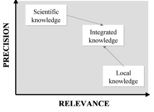
Habarurema and Steiner, 1997; Norton et al., 1998).) These include the use of qualitative database analysis and Geographical Information Systems (GIS) as an integration domain which was done by Payton et al. (2003) in the study conducted in East Africa and Bangladesh. Another methodology is the integration through the social learning approach which was done by Reed et al. (2007) in Kalahari, Botswana. Some other studies have used the comparison methodology to find possible correlations that can form the basis for integration (Birmingham 2003, Gray and Morrant, 2003; Oudwater and Martin, 2003). Such initiatives show that scientists have recognized that farmers hold valuable information about micro-scale variations within their environment (Cools et al., 2003). As much as scientific information can be very precise, its relevance to local people can be relatively low (Figure 2.1). Despite relatively low precision, local knowledge can be very relevant (Figure 2.1). This shows how both indigenous and scientific approaches will never be effective and sufficient as dichotomous entities but only as a unit.
Indigenous knowledge will provide scientists with insights into natural resource management valuable for local resource conservation (Krasilnokov and Tabor, 2003; Marenya et al.,