Examination Copy
A survey to assess perceptions on the value of examining survey records within the Surveyor-General(s) Office(s).
By
Oliver Allan Rowe
Submitted in partial fulfilment of the academic requirements for the degree of Master of Land Information Management in the School of Environmental Sciences
University of KwaZulu-Natal
Pietermaritzburg December 2011
ii
DECLARATION
I. The research reported in this dissertation, except where otherwise indicated, is my original work.
II. This dissertation has not been submitted for any degree or examination at any other university.
III. This dissertation does not contain other persons’ data, pictures, graphs or other information, unless specifically acknowledged as being sourced from other researchers.
IV. This dissertation does not contain other persons’ writing, unless specifically
acknowledged as being sourced from other researchers. Where other written sources have been quoted, then:
a) Their words have been re-written but the general information attributed to them has been referenced;
b) Where their exact words have been used, their writing has been placed inside quotation marks, and referenced.
V. Where I have reproduced a publication of which I am an author, co-author or editor, I have indicated in detail which part of the publication was actually written by myself alone and have fully referenced such publications.
VI. This dissertation does not contain text, graphics or tables copied and pasted from the Internet, unless specifically acknowledged, and the source being detailed in the dissertation and in the References sections.
Signed: ……….. Date: ………
O.A. Rowe (Candidate)
Signed: ……….. Date: ………
Prof. Trevor Hill (Supervisor)
iii
ACKNOWLEDGEMENT
There are many people who have assisted in making this research possible. To start I would like to take this opportunity to thank my wife and kids for allowing me the time to complete this research. It has been a long and time consuming endeavour, which has had to fit into an already hectic schedule. Thank you for your patience, encouragement and for the sacrifices you have had to make to make it possible.
To my work colleagues, thank you for your assistance, for allowing me the opportunity to vent my frustrations, to bounce ideas and findings off of you and for your valued input that always followed. To my Head of Department, thank you for allowing me the time and for pushing me and informing me of the reality of the situation should I not complete this. Your,
‘not beating around the bush’ approach is greatly appreciated, certainly in this circumstance.
To all the Professional Land Surveyor(s) who responded to the questionnaire and the examiners at the Surveyor-General(s) Office(s), thank you for provided your valued input, without your input this research would not have been possible.
iv
ABSTRACTThe examination of survey diagrams and records submitted by Professional Land Surveyor(s), has been the responsibility of the Surveyor-General(s) Office(s) in South Africa since the passing of the Land Survey Act 9 of 1927 and its successor, the Land Survey Act 8 of 1997. As it stands Professional Land Surveyor(s), registered with the South African Institute of Professional and Technical Surveyors, are the only persons authorised to place and replace cadastral boundaries. Together with the Surveyor-General(s) Office(s), they ensure the integrity of our land tenure system. This research investigated the perceptions of the Professional Land Surveyor(s) and the examiners, as to whether this examination process is necessary to ensure the integrity of the land tenure system, or whether it is a mere hindrance to the registration of land within the Deeds Office(s). A qualitative research approach was undertaken whereby a questionnaire was developed and distributed to all registered Professional Land Surveyor(s) operating in KwaZulu-Natal. In addition, semi- structured interviews were performed at the offices of the Surveyor-General with the staff involved with the examination process. It was established that the examination, although perceived as a delay in the registration of property, is vital and if compromised there is a distinct risk of losing the security and integrity that presently exist within the cadastral system. It would appear that the integrity of our cadastral system is not found solely in the professional land surveyor or the examination section, but rather that the combined efforts of the two parties provides an end product that is accurate, correct and ensures that the integrity of the cadastre system is maintained.
v
TABLE OF CONTENTS
DECLARATION ii
ACKNOWLEDGEMENT iii
ABSTRACT iv
TABLE OF CONTENT v
LIST OF FUGURES viii
LIST OF TABLES viii
CHAPTER ONE: Introduction 1
1.1 Land Surveying 1
1.2 South Africa 3
1.3 Statement of the Problem 5
1.4 Research Aims and Objectives 6
1.3.1 Aims 6
1.3.2 Specific Objects 6
1.5 Research Methodology 6
1.4 Conclusion 7
CHAPTER TWO: Literature Review 8
2.1 Surveying 8
2.2 Cadastral Systems 10
2.3 Establishment of a Cadastral system in South Africa 13
2.4 Land Tenure in South Africa 14
2.5 Examination in South Africa 15
2.6 The Land Survey Act 8 of 1997 18
2.7 Qualitative Approach 19
2.8 Quality of data 20
2.9 Conclusion 22
CHAPTER THREE: Methods 23
3.1 Introduction 23
vi
3.2 Case Study Approach 23
3.3 Data Collection Methods 24
3.3.1 Observations 24
3.3.2 The Interview 24
3.3.3 The Questionnaire 25
3.3.4 Study Site 26
3.4 Pilot Study 27
3.5 The Structure and Content of the Questionnaire 28
3.6 Semi-Structured Interviews 30
3.7 Conclusion 31
CHAPTER FOUR: Results 32
4.1 Introduction 32
4.2 Section A – General Information 32
4.3 Section B – Cadastral Surveying 33
4.4 Section C – Survey Records 36
4.5 Section D – Reduction in Examination of Data 38
4.6 Conclusion 39
CHAPTER FIVE: Discussion 41
5.1 Introduction 41
5.2 South African Cadastral system 41
5.3 Demographics of Survey Responses 42
5.4 Examination Process 43
5.5 Sub-Standard Work 44
5.6 Examination Period 45
5.7 Reduced Examination Process 46
5.8 Conclusion 48
CHAPTER SIX: Conclusion 49
6.1 Conclusion 49
REFERENCES 51
vii
APPENDIX A 54
LAND SURVEY ACT 8 OF 1997 – POWER AND DUTIES OF SURVEYOR GENERAL 54
APPENDIX B 57
LAND SURVEY ACT 8 OF 1997 – IMPROPER CONDUCT OF LAND SURVEYORS 57
APPENDIX C 59
SURVEYOR GENERAL DIAGRAM EXAMINATION DOCKET 59
APPENDIX D 60
SURVEYOR GENERAL SURVEY RECORD DOCKET 60
APPENDIX E 61
QUESTIONNAIRE DISTRIBUTED TO PROFESSIONAL LAND SURVEYORS 61
APPENDIX F 66
EXAMPLE SURVEY DIAGRAM (JUNE 1895) 66
APPENDIX G 67
EXAMPLE SURVEY DIAGRAM (DECEMBER 1986) 67
viii
LIST OF FIGURES
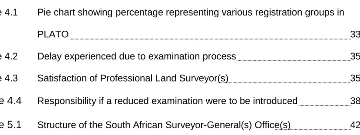
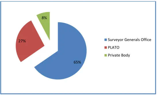
Figure 4.1 Pie chart showing percentage representing various registration groups in
PLATO 33
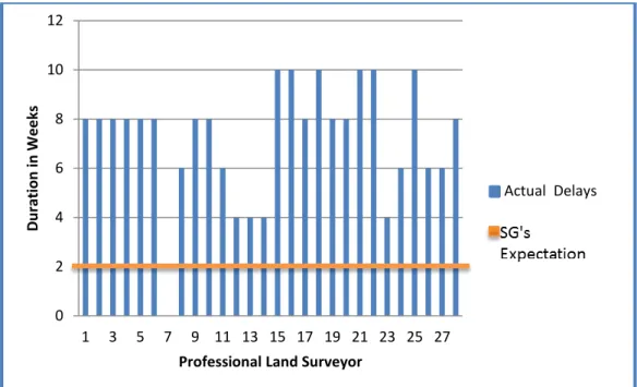
Figure 4.2 Delay experienced due to examination process 35
Figure 4.3 Satisfaction of Professional Land Surveyor(s) 35
Figure 4.4
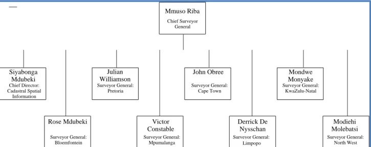
Responsibility if a reduced examination were to be introduced 38Figure 5.1
Structure of the South African Surveyor-General(s) Office(s) 42LIST OF TABLES
Table 1.1
Cadastral Surveying – South African Time Line 41
CHAPTER ONE Introduction
1.1 Land Surveying
Surveying is defined by Kavanagh (2007: 2) as the “art and science of taking field measurements on or near the surface of the earth.” These measurements are collected in the field and usually comprise of all, or a combination of, horizontal and vertical angles, horizontal or slope distances and vertical distances. Through the manipulation of these field measurements, the surveyor is able to facilitate the design of roads, buildings, locate and establish property boundaries determine volumes and calculate areas (Kavanagh, 2007).
The discipline of surveying is broken down into many professionalised areas of which Engineering, Topographical, Hydrographical, Mining and Cadastral surveying are generally regarded as the key foci (Kavanagh, 2007). Although these specialist fields exist, it is not uncommon for them to integrate to provide a service to both Government and the private sector.
Surveying has been described as one of the oldest professions in the world, having its roots in Biblical times; Deuteronomy 27:17 states, “Cursed is he who moves his neighbours boundary marks”. McCormac (1991: 1) “it is impossible to determine when surveying was first used, but in its simplest form it is surely as old as recorded civilization”. Archaeologists have discovered that the Egyptians were the first to use survey measurements, around 1400 BCE, to define property boundaries during their shift from a nomadic existence to a more settled, food producing existence where the importance of property and boundaries had become necessary to show ownership and rights to land (McCormac, 1991). Evidence of this was found as permanent markers placed above the flood plains of the Nile which were used to re-establish the property boundaries after flooding. It is believed that rudimentary surveying was used to position the Great Pyramids of Gizeh, through effective
2
means of rope pulling and diagonal measuring resulting in errors of approximately 8 inches, over a 750–feet base (metric equivalent 20.32 cm over a base of 228.60 m) (McCormac, 1991). There is proof that the Babylonians in 2500 BCE practised some form of surveying as archaeologists have located maps on tablets from this time period. Furthermore, evidence from paintings on the walls of the tombs suggests that not only was surveying used to establish property boundaries, but also used as a form of public land registration which was primarily used for taxation purposes (McCormac, 1991). This system is similar in many respects to land registration systems in existence today.
Shifts in technological ability have resulted in changes in the methods of accomplishing surveying, from the rope pulling Egyptians and the measuring wheel of the Romans to digital total stations, global positioning systems, laser levels and electronic distance measurers. Regardless of the tools used, the need to establish and maintain property boundaries continues. In Australia, it is dated to the start of the country’s colonization in approximately 1788 and is now accomplished by land surveyors working in the private sector who are register or licensed with the governing body and are therefore permitted to work in the cadastral section of land surveying (Cadastral Template, 2011). China’s modern cadastral system began in 1930 for the purpose of tax collection and ownership. Only licenced companies are permitted to perform such surveys. Sweden’s cadastral system dates back to 1530 and was established for taxation purposes for the King. The system was well advanced in that each village and unit in the village was provided with a unique number, which is still used in their land registration system today (Cadastral Template, 2011). By the 17th century the books providing the unique numbers were enhanced with maps (Österberg, 2003). This is similar to the Domesday book commissioned in the 11th century by William the Conqueror, which contains records of settlements in the English counties, for the purpose of managing taxations and military services for the King (The National Archives, 2011).
3
1.2 South AfricaIn 1652, Jan van Riebeeck arrived at the Cape of Good Hope, instructed by the Dutch East India Company to establish a refreshment station for passing ships. It was soon realised that to achieve this, farming and producing of suppliers would need to take place resulting in a change to the existing land management and, in 1657, Mr Pieter Potter completed the first survey (Simpson and Sweeney, 1973). Thus, commenced South Africa’s move from a customary land management system, where a tribal authority managed and distributed land, to a statutary land management system based on ownership document of surveys filed and used to re-establish boundary positions if removed or damaged. This practise of property surveying continued and developed, resulting in the Land Survey Act 9 of 1927, used to guide the surveying profession, subsequently replaced by the Land Survey Act 8 of 1997. Prior to 1652, the cadastral system in South Africa resembled that of a customary land tenure system which, over the last 350 years, has undergone major changes; from the first survey diagram completed by Pieter Potter in 1657, the appointment of a Surveyor- General in 1829, to legislation being adopted by the passing of the Land Survey Act 9 of 1927 and the examination of survey data that commenced in 1836 (see Table 1.1 for a detailed timeline) (Simpson and Sweeney, 1973).
At present, land registration and cadastral survey fall under the Department of Rural Development and Land Reform (DRDLR), at the time of the field work the Department of Land Affairs and cadastral surveys are accomplished in the private sector by Professional Land Surveyor(s) who are registered with the South African Institute of Professional and Technical Surveyors (PLATO). Registration is accomplished by completing a four-year degree in land surveying followed by a practical article period and passing of survey law exams. The primary function of the
4
1659 Peter Potters Diagram used to re-establish boundaries Penalities for Boundary markers being removed Rectilinear Boundary Change from rectilinear boundaries to general i.e. fences, walls, ditches etc 16621751 Abbe de Lacaille Measures Arc of Meridian, establishes earths shape
1813 1813 Proclamation by the Governor Sir John Cradock " Land not recognised unless Surveyed and Registered" First Surveyor General Colonel CC Michell No Examination of Survey or Diagrams 18291834 The Great Trek. Introduction of a Proficiency Exam for land surveyorsExamination of Survey Diagrams 18361845 Natals First Surveyor General Dr. Stanger
Theodolites to be used for surveys Numerical data to be shown on diagrams 18571858 Cape foot introduced as unit of measure
1886 Gold is discovered
Sir David Gill, commenses Geodetic system, producing Trigonometrical station for cadastral and mapping purposes 18831904 Need for a code of conduct and discipline is realised, legislation is enacted, land survey institutes to handle Land Survey Act 9 of 1927, passed in Parliment Method of Survey and Diagrams are Examined Surveys must be connected to the trigonometric system 19271950 Code of Professional Conduct, enforced through Central Council of Elected Land Surveyors
1918 Legislation provides "The Conduct of Land Surveyors" 1997 Land Survey Act Act 8 of 1997, replaces Act 9 of 1927
Sectional Title Act 1971
Investigation into digital data lodgement 2000 No Major Changes
CADASTRAL SURVEYING - SOUTH AFRICAN TIME LINE
1652 Jan van Riebeeck Arrived at the Cape of Good Hope First Survey accomplished by Peter Potter, of the Liesbeeck River for Jacob Cloeter (Diagram Produced) 1657
Chieftom / Customary Land Tenure
Table1.1 – Cadastral Surveying – South African Time Line
Table1.1 – Cadastral Surveying – South African Time Line
5
cadastral system in South Africa is to define ownership rights, although taxation on property does occur. It is for this reason that accuracy and correctness of submitted data is achieved within our cadastral system. In the early stages of South Africa’s cadastral development no examinations were undertaken of the diagrams produced, such as the first survey
accomplished by Pieter Potter, which, according to Simpson and Sweeney (1973) proved insufficient when required to relocate the land parcel’s boundaries only two years later. This is clearly not acceptable when legal implications of ownership are at stake. After many years of gradual improvements to the South African cadastral system the first cadastral data was submitted and examined in 1836.
1.3 Statement of the Problem
The South African cadastral system has undergone minor change since the Land Survey Act 9 of 1927 and the succeeding Land Survey Act 8 of 1997. The Land Survey Act 9 of 1927 established that both the process of the survey, reflected in the survey records, and the property diagrams need to be examined for consistency, accuracy and reflecting the latest changes within the land tenure system. This examination system is twofold as dockets are first inspected for detail and visual correctness after which the docket is examined for survey correctness and consistence against the existing data held at the Surveyor-General(s) Office(s). This process is manual, with assistance through computer- based software. The general perception from industry is that the examination of data is a necessity and stricter examinations systems should be implemented and enforced to ensure sound data quality. However, the question needs to be asked why registered professionals, who take responsibility as laid out in the Land Survey Act (Land Survey Act 8 of 1997, Section 11) need to have their workmanship examined?
6
1.4 Research Aim and Objectives1.4.1 Aim
The aim of this research is to document and discuss whether the examination of survey records, within the Surveyor-General(s) Office(s), is perceived as either a necessity to ensure the integrity of our land tenure or a hindrance to the registration of land within the deeds registry. A secondary aim is to assess perceptions regarding reducing the examination process.
1.4.2 Specific Objectives
To achieve the above aim the specific objectives were to:
a) understand the perceptions of the Professional Land Surveyor(s) and examiners at the Surveyor-General(s) Office(s) towards the examination of cadastral data in KwaZulu-Natal, as necessary to ensure the integrity of our land tenure system;
b) assess the interest in the implementation of a reduced examination process by KwaZulu-Natal Professional Land Surveyors.
1.5 Research Method
The research was achieved through a qualitative approach which commenced with unstructured interviews with the examination team at the Surveyor-General(s) Office(s).
These unstructured interviews along with observations of the stages of examination were used to construct a perception questionnaire. Through a pilot study the questionnaire was refined before being emailed to all Professional Land Surveyor(s) registered with PLATO in the KwaZulu-Natal area. The raw data was then summarised to assist with the semi- structured interviews of the examination staff at the Surveyor-General(s) Office(s).
Common themes were identified and analysed along with any interest in a reduced examination process.
7
1.6 ConclusionsLicensing and registration are frequently portrayed as a mark of professional competence and thus a form of protection to the wider community. This being the case, it is questionable why survey examination by Surveyor General’s Offices should be necessary, if the people providing the data are professionals. Thus, the question arises whether it is necessary to have survey examinations, which ultimately protects the professionals from the consequences of their errors as suggested by Kentish et al. (1999).
Engineering surveyors in South Africa, whose projects are more costly, in monetary terms, take full responsibility for their surveys and no examination body exists to check their work.
They are however protected by having professional indemnity insurance which protects against claims due to any professional negligence. The difference between engineering surveyors and land surveyors is the time factor, in that engineering work is utilised within a short time frame and mistakes can be determined and the necessary action taken; whereas in land surveying, the diagram may only be used in 10 -20 years and the ability to place responsibility becomes difficult.
Having no examination may not be the answer, however a reduced examination process could assist South Africa in reducing the work load on the examination staff at the Surveyor-General(s) Office(s) and increase the efficiency of diagram approval. The perception of the stakeholders towards a reduced examination process will be addressed in this research as well as the perception as to whether it would benefit South Africa’s cadastral system or jeopardise the quality of the data presently being submitted and managed by the Surveyor-General(s) Office(s)?
8
CHAPTER TWO Literature Review 2.1 Surveying
The art of surveying is the observation and combination of the measurements taken in the field, and the manipulation through scientific means to produce an outcome such as positioning of a building, roads, dams, areas, volumes, maps and diagrams (McCormac, 1991). Surveying is subdivided into two distinct areas, geodetic and plane survey. The difference between the two is the size of the area being surveyed. Geodetic survey deal with large areas, such as provincial boundary surveys and corrections need to be made to take into consideration that the surface of the earth is rounded or ellipsoidal in shape.
However, plane surveying is conducted at a smaller scale/size and consequently the surface of the earth can be assumed to be flat, thereby allowing a parallel grid to be placed over the area. This grid is referred to as a YX or an easting northing grid. Properties are registered on a mapping plan which is a projection from the curved earth surface, and hence cadastral surveying is two dimensional.
Surveying is a generalist term used to describe the many different areas in which surveyors apply their skills. The five dominate fields of enquiry are engineering, topographical, hydrographical, mine and cadastral surveying. Kavanagh (2007: 3) defines engineering survey as “those activities involved in the planning and execution of survey for the location, design, construction, maintenance, and operations of civil and other engineering projects”, such as road construction and stadiums. It is in this field that surveyors work closely with civil engineers to ensure that construction is taking place in the correct area, is connecting to existing structures and is following the design set down by the civil engineers.
Topographical surveys are the creation of a three-dimensional model, the third dimension being made visible by showing contour lines, which are lines drawn on plans or maps
9
joining all places of equal height. “Detailed information is obtained pertaining to elevations as well as to the locations of constructed and natural features (building, roads, streams, etcetera.) and the entire information is plotted on maps (called topographic maps)”
(McCormac, 1991: 5).
Hydrographic surveying pertains to the sea, lakes, streams and other bodies of water where the establishment of flood control and shapes of areas beneath water surfaces are determined says McCormac (1991). This particular type of survey requires specialised equipment which is very different to the other four types of surveys, which can be accomplished by standard survey practises and equipment, that of GPS, total stations and EDM.
Mine surveying is a very specialised field of work and, in South Africa, to practise one needs to be registered with the Institute of Mine Surveyors of South Africa. In this type of survey one deals with below ground survey, but relates the position to that on the earth’s surface (McCormac, 1991).
Cadastral surveying is regarded as the oldest type of surveying (McCormac, 1991) and deals with the tracing of existing land ownership boundaries or the creation of new boundaries (Kavanagh, 2007). This type of surveying is reserved for Professional Land Surveyor(s), registered with the South African Council for Professional and Technical Surveyors (PLATO). It is within this area of survey that this research will focus as it deals with cadastral data submitted by registered Professional Land Surveyor(s) to the Surveyor- General(s) Office(s) and the examination that takes place to ensure accuracy and consistency, thereby ensuring the integrity of a land administration system.
10
2.2 Cadastral SystemsSince colonial times, the cadastral system has primarily been a means of providing a spatial and written description of land parcels for the purpose of acquisition and registration of land rights (Silayo, 2002). It is for this reason that a huge demand and interest has been placed on developing and monitoring a successful cadastral system within countries. “Not only do cadastral boundaries provide for legal protection regarding ownership” (Bogaerts and Zevenbergen 2001:1) but, according to Silayo (2002), also provides a source of revenue for the States. For a cadastral system to be beneficial it must contain, according to Williamson (1983), the following elements:
1. The introduction of cheap, secure and efficient system of recording and transferring interests in land.
2. The reduction of boundary disputes and expensive related litigation.
3. The ability to increase long-term credit by using land title as security. In urban areas this leads to increased land development and an improved land market. In rural areas it promotes long term farm planning, better cropping patterns, long term crop management and soil conservation practices, and enables the farmers to buy more efficient equipment to invest in farming improvements programs.
4. The ability to establish an efficient and equitable taxation system. With such a land system, all land parcels may have a tax levied on them, based on realistic value. In simple terms, land cannot be taxed unless the location, size and ownership of the land are known.
5. The ability to prepare an up-to-date cadastral map which has many uses other than for land registration and conveyancing, such as local administration, planning, utility authorities and private organisations.
6. The use of the cadastral system to control land transactions and ownership, for example many countries desire to restrict ownership of land by aliens.
11
7. The use of the cadastral system as the basis for land reform. Without such a system, land reform can be a lengthy process with a reduced chance of success.
8. The development of a cadastral system, and particular the creation of the cadastral maps in a systematic manner, which makes it possible for a Government to determine the amount of state land it owns. This fact alone has been sufficient justification for some countries to carry out a cadastral survey, such as the Domesday Book of the English in 1085 (The National Archives, 2011).
9. The creation of an efficient system based on title registration in a form which is readily computerised. With the advances in computer design, in conjunction with reduced costs for computers, simple, computerised non-graphic ‘Land Information systems’ are becoming a realistic proposition.
Thus, it is clear that a cadastral system is multi-functional and can provide benefit to both the Government and private sector. According to Borgaerts and Zevenbergen (2001), cadastral systems vary worldwide and no two systems are truly alike; instead each is a variant or an adaption of more than one system ensuring a cadastral system that fulfils the needs of Government and the private sector. Bogaerts and Zevenbergen (2001: 326) note,
“It is important for all cadastral experts, whether they are local or foreigners to know that there are many alternatives, which in general, give a good solution”. The list below provides a breakdown of the variation that exists between cadastral systems (Bogaerts and Zevenbergen 2001);
1. The decentralised versus the centralised cadastral system, which defines whether the cadastral system for a country is managed locally i.e. in each of its regions/
provinces (for example Poland has 400 cadastral offices), or whether data is managed in a central location and then distributed to the various regions.
12
Improvement in telecommunication has resulted in the location of cadastral information being less relevant.
2. The land registration and the cadastral system may exist as one system or be viewed as two separate entities – (Austria, Bulgaria and Poland have these separated). It is interesting to note that seventy per cent of the attributes required for land registration and cadastral system (Bogaerts and Zevenbergen 2001: 331) are duplicated, resulting in maintenance being labour intensive, especially in old manual systems.
3. The cadastral system may be established for fiscal or legal purposes. A fiscal cadastral system is established for taxation reasons which is the sector within which most cadastral systems are established and is cheaper and simpler to maintain and establish compared to a legal cadastral which is established to prove ownership (Bogaerts and Zevenbergen 2001: 331). It is this legal systems that requires constant updating to ensure accuracy.
4. The cadastral system of fixed or general boundaries. “Whether it is in deeds, for land registration or on cadastral maps, the unit of land that makes up a certain property (parcel) has to be defined and identified” (Bogaerts and Zevenbergen, 2001: 331). General boundaries are identified by natural or artificial features found on the ground, such as a hedge, path, river etcetera. However, with a fixed boundary the responsibility lies with the land surveyor to indicate the position of each boundary in a permanent way, using suitable equipment and with a high degree of accuracy. This method is slow and more costly than the general boundary method and has resulted in many countries such as Tunisia and Tanzania taking many years to establish a fixed boundary cadastral system. Silayo (2002) states that in the 10 years from 1991 – 2001 only 8 021 plots were surveyed annually in Tanzania where the national demand was established at 150 000 plots.
13
5. The cadastral system may be government controlled or a self-supported system. In a government supported system, such as with many Europeans countries, the government maintains the system and any income goes directly into the state treasury. This implies that the government provides the funding for the cadastral system. On the other hand, in the Netherlands, the national cadastral system has been privatised and has become an independent organisation. “Since then, the fees have been reduced by about fifty per cent, the organisation is fully self-supporting and operates with an annual surplus” (Bogaerts and Zevenbergen, 2001: 334).
2.3 Establishment of a Cadastral System in South Africa
The cadastre system in South Africa commenced in 1652 when Jan van Riebeeck landed at the Cape and brought with him a Eurocentric approach to land ownership, that of
“deposition over the land and the right to use the land” (Bonn 1980: 7). Bonn (1980) states that prior to this method of ownership, land was managed under the tribal system and granted by the chieftain to members of his/her tribe. Although Jan van Riebeeck was ordered to merely set up a fortified trading station, which was to be used as a supply stop to ships bound for the East, it soon become apparent that a more formal institution would be required to provide food, and so ‘free burghers’ were granted 20 acre plots to meet the demands of the passing ships. According to Simpson and Sweeney (1973) it was at this stage that the value of property was established and the necessity to survey and demarcate its’ position became a necessity.
The importance of the surveyor and surveys grew as land became a sought after commodity. “Pieter Potter was the first to survey land along the Liesbeeck River for the purpose of transferring it from the Dutch East India Company to servant Jacob Cloeten, a free Burgher”, says Simpson and Sweeney (1973: 14). The position of the beacons and boundaries were then drawn up and became part of the first land title, which comprised
14
much of what is standard practice for document submission today at Surveyor-General’s Office(s) nationwide; that of land ownership, the rights bound to the land, and the position and the size of the land parcel. Simpson and Sweeney, (1973) state that two years later, the document created by Potter was put to the test as it was used to re-establish the position of the boundary of Jacob Cloeten’s property and was found to be inaccurate. As a result, the original boundary’s position was impossible to re-establish, thus placing huge importance on correctness and accuracy of such a document. Two possible reasons for these inaccuracies in the diagram established by Pieter Potter could have been the equipment used to establish direction, that of magnetic compasses, plane tables and circumferentor, and the ability to measure distance through timed horseback rides or foot pacing.
This is rudimentary in comparison to today’s standards of equipment, where angular accuracies of one second can be measured and network accuracies of one millimetre can, and are, being achieved.
2.4 Land Tenure in South Africa
Land tenure is described as the system of rights and institutions that govern access to and use of land (United Nations, 2003). The United Nations Economic Commission for Africa indicates that in South Africa there are two land tenure system operating, that of customary and statutory tenure. Tembo (2008) confirms this and sub-divides the statuary tenure system into that of freehold and leasehold. Customary tenure “is a land tenure system that is governed by unwritten traditional rules and administered by traditional leaders” (United Nations, 2003: 2). Ownership is made evident by showing use, building houses etc. and by following conditions, yet this ownership does not allow for use as collateral for loans from banks. Diagrams and paper documents showing and demarcating one person’s land from another are not requirements of customary tenure. However, statuary tenure provides the
15
owner with exclusive rights, which guarantees land tenure security. This system requires management as this tenure system is supported by documentary evidence and administered by the Government. It is this system that requires the examination of the documents submitted by Professional Land Surveyor(s). Only once these documents are approved and registered in the Deeds Office(s), is security of tenure awarded to the owner who is then granted exclusive rights.
2.5 Examination process in South Africa
As the importance of survey diagrams in providing security of tenure grew, so the abilities of surveyors needed to be improvement and, in 1834, an examination system was introduced to improve the proficiency of the land surveyors. The exam comprised of four stages: proficiency in drawing, the elementary principles of geometry, the practical application of surfaces, heights and distances, the element of nautical astronomy, finding the latitude, variation of the compass and the practical examination in the field to test the candidate’s abilities Simpson and Sweeney, (1973).
This examination was supplemented by ensuring that all land surveyors’ pay a deposit to the Government to cover any faulty survey produced by the individual, which was used to cover the costs involved in re-surveying. It was at this stage that a separation between surveyors occurred; those who completed the above mentioned examination were regarded as ‘Government surveyors’, able to survey Government land, and those not having complied were regarded as ‘Sworn surveyors’, permitted only to work on private land. Two years later, in 1836, the diagrams produced by either Government or Sworn surveyors were examined in the Surveyor-General(s) Office(s) to ensure that the work undertaken and submitted was of a suitable standard to ensure security of tenure.
16
In 1904, the South African Supreme Court stated that the lawful position of a property beacon is according to the diagrammatic representation of it and not necessarily according to the original beacon itself (Simpson and Sweeney, 1973). A decision was taken by Government that the position of the boundary reflected on the diagram, submitted by the surveyor, is the lawful and true position. This law increased the land surveyors responsibility as the diagrams produced reflect the true position and any errors will result in the property boundary being compromised which could have severe consequences for the occupants of the land and resulting in boundary disputes. However, in 1924 the law was reversed to specify that the lawful position is no longer that of the diagram but rather the position of the original beacon as it stands in the ground (Simpson and Sweeney, 1973).
This rule still exists and is practiced today by all Professional Land Surveyor(s) in South Africa. Once again, this demonstrated the importance of accuracy and an increase in the responsibility placed upon registered land surveyors, as their documents are now recognised, accepted by law and used to prove land title.
The examination of the diagrams continued until 1927 when, for the first time, not only the diagrams, but also the survey records were examined. The survey record provides information regarding how the surveyor fulfilled the survey, in term of how he /she established control by observing trigonmetrical beacons or town survey marks, which property beacons were observed and from which point they were observed and all the necessary calculations, reductions and comparisons required to ensure that property boundaries and diagrams are correct. These records were examined and held as evidence, for future boundary relocations, within the Surveyor-General(s) Office(s) (Simpson and Sweeney, 1973). The examination and approval of the surveys is still practised in this manner today.
17
Although much research has been undertaken with regards to the survey system (Bevin and Haanen, 2002; de Vries 2004; Falzon and Williamson 1998, Kentish, Jones and Rowe, 1999) little information is available regarding the examination of survey data by the Surveyor-General(s) Office(s) with particular reference to South Africa.
In South Africa, at a Surveyor-General(s) Office(s), all documentation is thoroughly examined and checked for accuracy, consistency and methodology by examiners who are registered land surveyors working for the State. In Australia and New Zealand, the examination of documents submitted by surveyors has been reduced to ten per cent of the plans lodged and these are examined for quality purposes only, to ensure that the standard are maintained, with the remaining passing through without examination (Falzon and Williamson, 1998).
In the case of Australia, the reduced examination process has been accomplished through the introduction of an accreditation scheme to which surveyors can affiliate themselves (Falzon and Williamson, 1998). Bevin and Haanen (2002) reiterated this by stating that in New Zealand surveyors who demonstrate a level of quality, specified by an accreditation standard, are provided with a reduced examination process on submission of their data.
This accreditation scheme is managed by an organisation, either government or private. In South Australia it is managed by the Land Service Group (LSG), in Western Australia the Department of Land Administration (DOLA) and in New Zealand by the Land Information New Zealand. Although not addressed in this research project, the above points raise pertinent questions for South Africa. Who would be responsible for such an accreditation scheme; who has the capacity to oversee this? Would accreditation rest with PLATO, or would it rest with the Surveyor-General(s) Office(s); or would a new accreditation body have to be established (Government or private?) to monitor the success of such an accreditation scheme? Would Professional Land Surveyor(s) pay for such privileges, or
18
would they be accommodating of the fact that they might need to undergo regular annual testing to remain accredited, such as continual professional development points (CPD)?
Such questions could be the focus of further research in this field.
2.6 The Land Survey Act 8 of 1997
The examination of cadastral data in South Africa started in 1834 and comprised the examination of survey diagrams. In 1927, both the diagrams and survey records were examined, as a result of the passing of the Land Survey Act 9 of 1927 (Simpson and Sweeney, 1973). This Act has since been superseded by the Land Survey Act 8 of 1997, which dictates the responsibilities and the authority of the Surveyor-General towards storing and maintaining of the data and the examination of submitted data. The Act also dictates the responsibilities of the land surveyors with respect to the submission of new data for examination (Appendice A). It is interesting to note that in the Land Survey Act 8 of 1997 (section 11(b)) it indicates that the land surveyor takes full responsibility for the survey and no responsibility lies with the Surveyor-General(s) Office(s). In the Land Survey Act 9 of 1927 (section 13(3)), this was expressed in the following manner, “Neither the Government nor any officer thereof shall be liable for any defective survey or work pertaining thereto, performed by a land surveyor”. Based on this understanding, it is strange that so much effort is placed on the examination of data when the responsibility for the integrity of the data lies with the land surveyor and not those examining the data. Again, one needs to ask the question whether this examination of data is necessary or merely a hindrance to the registration process, if responsibility lies with the land surveyor, as indicated in the Land Survey Act 8 of 1997, then surely they should ensure that their work submitted is in the correct format and error free?
Further, the Land Survey Act 8 of 1997 (section 12(1)) deals with improper conduct of a land surveyor (Appendice B). The seriousness of contravening this Act and the punishment
19
that could be implemented by PLATO may deter any land survey and ensure commitment to accurate and error free data submissions to the Surveyor-General(s) Office(s), thereby eliminating the need for examinations.
2.7 Qualitative Approach
As perceptions are gauged by qualitative research, this section provides a discussion on qualitative research and the methods used to collect and assess data. Qualitative research is “primarily to describe a situation, phenomenon, problem or event; the information is gathered through the use of variables measured” (Kumar 1999: 10). It is, “primarily an inductive process of organising data into categories and identifying patterns (relationships) among categories” (McMillian and Schumscher 1993: 479). Qualitative research is used to enable the researcher to obtain data, in a natural environment through techniques of observation, interviews and questionnaires states Kumar (1999). This data is referred to as primary data as it is obtained by first hand. Kumar (1999) and Mays and Pope (2000) indicate that although the data is primary, it is not 100% accurate leading to possible errors in qualitative research. As a researcher, the ability to control and improve validity/
trustworthiness is important. Mays and Pope (2000) suggest ways of ensuring validity of qualitative research through the following: that of triangulation, a clear exposition of methods of data collection and analysis, reflexivity, attention to negative cases and fair dealings.
1. Triangulation – is aimed at being able to make a comparison between the result of two different methods of collecting data, finding consistent results, or a commonality between interview data and questionnaire data. This strengthens the validity of the data obtained.
2. Clear exposition of methods of data collection and analysis – as it is difficult to control responses in a natural setting, it is important to ensure that all means of data collection are presented and made transparent. “The written account
20
should include sufficient data to allow the reader to judge whether the interpretation proffered is adequately supported by the data” (Mays and Pope 2000: 51).
3. Reflexivity – relates to the structure setup by the researcher which is guiding the responses based on assumptions the researcher might have. This structure needs to be indicated at the beginning of the research.
4. Attention to negative cases – which deals with investigations into outliers and data that contradict or differ from the norm. Outliers or contradictory data/results should lead to further investigations and explanation for all data obtained.
5. Fair dealings – takes into consideration that the researcher has not limited the perspective to a certain group but rather ensured that the participants of the research cover a wide range so as to obtain a well-rounded response.
2.8 Quality of data
It is generally perceived by land surveyors that the security of land tenure in South Africa lies with the correctness of property diagrams and the accuracy of the work of the land surveyors who performed the survey. This examination of data at the Surveyor-General(s) Office(s) controls both of these steps and contributes to the land tenure security for all who have land ownership. As examination of data is taking place, the quality of that data under examination will directly affect the perceptions of the Professional Land Surveyor(s) and the examiners at the Surveyor-General(s) Office(s).
To understand quality in this environment it is necessary to view quality from two perspectives. The first, that of data, which is defined as the method of the survey undertaken along with the accuracy of the calculations and the correctness of the drawings, submitted in the form of survey diagrams, general plans and sectional titles schemes and whether the quality of this submitted data could ensure that the examination stage is no
21
longer necessary. However, is this quality achievable throughout the land surveyors or would the accuracy and integrity of our cadastral system be compromised? “This means that it is critical to measure the cost of quality or, more precisely, the cost of non-quality”
(Sterling 1993: 36).
The second aspect of quality with the service provided by the examiners is the Surveyor- General’s Office(s) service quality check that would ensure a short approval time? However a short approval time has a direct link with the quality of the data received. If poor work is submitted then the time to examine is lengthy, however if accurate, and correct work is submitted, then the time for approval is reduced. “Poor data quality increases operational cost because time and other resources are spent detecting and correcting errors” (Redman 1998: 80). Redman (1998) continues by stating that, “poor data quality makes it difficult to reengineer. One way of looking at many reengineered projects is that they aim to put the right data in the right place at the right time to better serve a customer” (Redman 1998: 81).
It must be mentioned at this point that one of the main customers at the Surveyor- General(s) Office(s) are the Professional Land Surveyor(s) using the data which ironically they provide. Therefore they will be directly influenced by the quality of their own work.
Service quality is a measure of how well the service level delivered matches customer expectations. Delivering quality service means conforming to customer expectations on a consistent basis (Lewis and Booms, 1983). If the examination process were to follow Lewis and Booms’s (1983) definition of service quality and conform to the expectation of its customers, in this case the land surveyors, would the cadastral integrity be maintained within the Surveyor-General(s) Office(s)? In this research quality will be defined as “Zero defects – doing it right the first time Crosby (1979).”
22
2.9 ConclusionsThe South African cadastral system has undergone many changes since inception in 1657, from the first survey being completed by Pieter Potter to a contemporary system that is managed and controlled by the State. To ensure that the integrity of this land tenure system remains, the examination and record of survey data was introduced when the Land Survey Act 9 of 1927 was implemented. The successor Act of 1997 still prescribes the responsibilities of the Surveyor-General and the professional land surveyor to ensure accurate and error free data. The question needs to be asked whether the data submitted requires examination or is the quality of work that is submitted to the Surveyor-General(s) Office(s) at a level that will continue to ensure the integrity of our land tenure system, even if a reduction in examination were to be implemented to speed up the registration process?
23
CHAPTER THREE Methods
3.1 Introduction
This chapter outlines the methodology used to accomplish the research, that being the perceptions of the professional land surveyor and the examiners at the Surveyor- General(s) Office(s), towards the examination of the work submitted by professionals. The perception of the professional land surveyor was established through the development of a questionnaire, and that of the examiners through a set of semi-structured interviews.
3.2 Case Study Approach
The qualitative research design for this research was based on a case study approach. “In a case study, a single person, program, event, process, institution, organisation, social group or phenomenon is investigated within a specific time frame, using a combination of appropriate data collection devices” (Creswell 1994). To achieve its purpose a case study
“is constructed to richly describe, explain or assess and evaluate a phenomenon” (Gall, Borg et al, 1996: 549) and it is accomplished through obtaining information on site generally through interaction between researcher and the participants/ respondents, thereby making the data collection that of a primary nature. This data, according to Gall, Borg et al. (1996), is analysed using three methods;
1. Interpretational Analysis – where the researcher is trying to establish patterns in the data,
2. Structural Analysis – where patterns are found when the conversations are investigated /analysed.
3. Reflective Analysis – where the study is handed over to a highly qualified expert to provide understanding using his/her judgement.
24
Once the analysis is complete the research communicates the findings. “The case narrative richly and fully reports the subject perceptions about the phenomenon being investigated”
(Leedy 1997: 158).
3.3 Data Collection Methods
Kumar (1999) describes three methods to obtain primary data, observation, interviewing and questionnaires.
3.3.1 Observations
“Observation is a purposeful, systematic and selective way of watching and listening to an interactive or phenomenon as it takes place” (Kumar 1999: 105). This method of data collection is adopted when the ability to obtain data through the other methods, i.e.
interviews and questionnaires, is ineffective. Kumar (1999) defines these situations as when the respondents are not co-operative or are unaware of the answers. This method of data collection is best used when the behavioural response is the type of data required.
This particular method has not been used in this research, instead the research has concentrated on the two methods as described.
3.3.2 The interview
“Any person-to-person interaction between two or more individuals with a specific purpose in mind is called an interview” (Kumar 1999: 109). Kumar (1999) suggests that there are two types of interviews which are classified according to their flexibility, that of an unstructured and a structured interview. In an unstructured interview, the researcher develops a framework called an ‘Interview guide’, which is used to provide a structure, where the questions are spontaneous in nature, resulting in freedom within this method to deviate slightly, but not outside of the framework. “In a structured interview the investigator asks a predetermined set of questions, using the same wording and order of questions as
25
specified in the interview schedule” (Kumar 1999: 109). Through this method uniform information is obtained which enables comparability of data.
Nuwaha (2002) provides another interview option, that of a semi-structured interview process, which provides a median between structured and un-structured design. In a semi- structured approach, questions are provided through the interview schedule, however freedom is allowed to ensure a greater perception to be obtained from the respondent within the research area, as the respondents not only answer the questions given but provide their views and opinions.
3.3.3 The Questionnaire
“A questionnaire is a written list of questions, the answers to which are recorded by respondents. In a questionnaire respondents read the questions, interpret what is expected and then write down the answer” (Kumar 1999: 110). Questionnaires and interviews will normally contain the same questions, however the means of the response is different. As a result questionnaires need to be structured carefully to ensure that the questions are simple and understandable as no interpretation is available, as in an interview. Kumar (1999) describes three situations where a questionnaire or an interview should be used:
1. The nature of the investigation – if personal or sensitive information is required which could result in the respondent being reluctant to discuss with the researcher.
2. The geographic distribution of the study population – where the respondents cover a wide geographical area.
3. The type of study population – “if the study population is illiterate, very young or very old, handicapped there may be no option but to interview respondents”
(Kumar 1999: 110).
26
Kumar (1999) suggests three ways of administrating a questionnaire, the mailed approach, the collective administration and the administration in a public place. The mailed approach is conducted either by post or emails but these suffer from a low rate (Kumar 1999). The collective administration is where you have a captive audience such as a classroom or conference and the public place method will be decided upon depending on your area of study.
3.3.4 Study Site
The geographical area of this study was KwaZulu-Natal, South Africa and the Professional Land Surveyor(s) that operate in the Province and submit data to the Surveyor-General(s) Office(s) which is located in the Department of Land Affair’s building, in Pietermaritz Street, Pietermaritzburg, KwaZulu-Natal. Contact was made with South African Council for Professional and Technical Surveyors (PLATO), to assist in providing a list of contact details for all registered Professional Land Surveyor(s), as PLATO is the governing body that ensures and controls professional registration, which is a prerequisite for submitting survey data to the Surveyor-General(s) Office(s). A total of 58 Professional Land Surveyor(s) were identified that operate and hold registration in the KwaZulu-Natal area.
Contact with these Professional Land Surveyor(s) was achieved through the use of email addresses obtained from the list, as the geographical distribution of the surveyors placed limitations on the ability to visit to conduct interviews.
As the necessity for examination of data forms the basis of this research, it was necessary to establish the perception of the two parties involved in the process; those of the professional land surveyors and the examiners working at the Surveyor-General(s) Office(s). These perception were ascertained through two sample methods; a questionnaire, were distributed to all the Professional Land Surveyor(s) and semi- structured interview with the examination heads at the Surveyor-General(s) Office(s). It is
27
important to note that the examination process at the Surveyor-General(s) Office(s) in KwaZulu-Natal comprises of two stages; the first stage is a technical examination which is managed by 13 examiners, comprising of two chiefs and 11 examiners working independently. The next stage is conducted by three Professional Land Surveyor(s), referred to as Professional Assistants (PA). (Refer to Appendices C and D, Surveyor- General’s Check list.)
3.4 Pilot Study
The questionnaire was developed, based on an initial interview with the examiners at the Surveyor-General(s) Office(s). This interview was used to better understand the process involved in the examination stage. The interview was un-structured so as to provide the examiners an opportunity to define the problems and concerns with which they are dealing on a day-to-day basis. On conclusion of this interview, a questionnaire was developed, which was structured in a manner necessary to answer the research problem and provide some alternative solutions. Telephonic contact was made with two Professional Lan