indicators for impact assessment
J. Taylor
CAEPR Working Paper No. 4/1999
ISSN 1442 – 3871 ISBN 0 7315 4903 1
Dr John Taylor is Deputy Director and Senior Fellow at the Centre for Aboriginal Economic Policy Research, The Australian National University.
Foreword
In 1996, the Kakadu Region Social Impact Study (KRSIS) was established by a range of parties, including the Commonwealth and Northern Territory Governments, to determine the social impact of development on Aboriginal communities in the Kakadu region. This study was deliberately structured (via an Aboriginal Project Committee) to ensure Aboriginal control of key aspects of the research process and to maximise involvement of the Aboriginal community. The overall study aimed to provide a clear statement of Aboriginal experiences, values and aspirations in relation to mining, tourism and other developments in the region. It also aimed to develop an Action Plan to address any negative impacts associated with these developments. However, despite two major previous social impact studies in the region (the Fox Inquiry, completed in 1977, and the Social Impact of Uranium Mining study, 1984) when faced with the task of profiling the employment, income, education, housing and health status of the Kakadu Aboriginal population in 1996 and of providing some analysis of how these might have changed over the previous 20 years, the KRSIS quickly found an absence of readily available and comprehensive information.
Hence in June 1996, as the project began, the Northern Land Council approached Dr John Taylor to provide the Aboriginal Project Committee of KRSIS with a statistical profile of the Aboriginal population of the region with a view to reviewing all existing information to establish trends in social and economic status.
This report was completed and submitted to the KRSIS in October 1996 and has formed the basis of much subsequent deliberation both by the Aboriginal Project Committee and by the Study Advisory Group, of which I was a member.
There are four important reasons for publishing this report in the CAEPR Working Paper series. First, while copies of Dr Taylor’s original report are available on request ‘in writing’ from the Environmental Research Institute of the Supervising Scientist in Jabiru, this is a cumbersome and sub-optimal mode of dissemination of important benchmark data. Also, it is not clear if this service will always be available. Second, as already noted, a major criticism of previous studies was their failure to generate a comprehensive and publicly accessible database. This potential problem is addressed here by providing free Internet access to the report as a CAEPR Working Paper. Third, the original report was completed well before the release of 1996 Census data. As there are major deficiencies in these data for the Kakadu region, an analysis has been made of these and included here for the record. Finally, the issue of the socioeconomic status of Aboriginal people in Kakadu remains of political, economic, cultural and policy relevance, as demonstrated, for example, by the UNESCO Kakadu Mission a year ago. The sort of quantitative and impartial research reported by Dr Taylor might facilitate informed debate on important development issues in this high profile region.
Professor Jon Altman Director, CAEPR November 1999
Table of Contents
Foreword ... i
Abbreviations... iv
Acknowledgments ... v
1. Scope and conduct of the analysis... 1
Terms of reference... 1
Analytical framework ... 1
Caveats ... 4
2. A demographic profile of Aboriginal people in the Kakadu region... 6
Population size... 6
Population growth ... 7
Population change by location ... 8
The 1996 Census count ... 10
Age and sex composition ... 12
Dependency ratios ... 13
Population mobility ... 14
3. Labour force status... 18
Aboriginal/non-Aboriginal labour force status 1991 ... 18
Current Aboriginal labour force status... 20
4. Income status and welfare... 28
5. Education: participation and outcomes... 34
School participation ... 34
School attendance... 37
Education outcomes... 38
Qualifications ... 40
6. Housing and infrastructure... 41
Housing and infrastructure at outstations ... 41
ANCA housing... 44
Housing in Jabiru ... 44
7. Health status... 46
Hospital separations ... 46
Stages of morbidity ... 48
8. Conclusion... 50
References ... 52
Notes ... 54
Tables and Figures Table 2.1. Aboriginal population counts and estimates: Kakadu National Park communities, 1991–95... 9
Table 2.2. Apparent population growth rates for Aboriginal communities in Kakadu National Park and Jabiru, 1991–95 ... 9
Table 2.3. Aboriginal population by place of enumeration in the Kakadu region, 1991 and 1996 ... 10
Table 2.4. Aboriginal population by place of usual residence in the Kakadu region, 1991 and 1996 ... 11
Table 2.5. Distribution of Aboriginal population by broad age group:
Kakadu region, 1995 and Jabiru ATSIC Regional Council
area and NT, 1991 ... 12 Figure 2.1. Age/sex pyramid of the Kakadu regional population, 1995 ... 13 Table 2.6. Aboriginal dependency ratios for Kakadu,
Jabiru Regional Council Area and NT ... 14 Table 2.7. Variability in population levels: Kakadu Aboriginal
communities, 1981–86 and 1992–95 ... 15 Table 3.1. Aboriginal and non-Aboriginal labour force status:
Kakadu region, 1991... 19 Table 3.2. Aboriginal and non-Aboriginal employment, unemployment
and labour force participation rates: Kakadu region, 1991 ... 19 Figure 3.1. Employment at RUM, 1982–96 ... 20 Table 3.3. Aboriginal employment in Kakadu National Park, 1996 ... 21 Table 3.4. Aboriginal employment, unemployment and labour force
participation rates: Kakadu region, 1991 and 1996... 21 Table 3.5. Aboriginal clients on Job Search Allowance/Newstart
Allowance/Youth Training Allowance by age, sex and duration of unemployment: postcode areas NT 0886
and NT 0882, 1996 ... 22 Table 3.6. Aboriginal employment at RUM, 1982–96 ... 23 Table 3.7. Percentage distribution of Aboriginal and all employees
by job grade: RUM, 1996... 24 Table 3.8. Full-time Aboriginal employment with ANCA by
occupational status, 1996 ... 25 Table 4.1. Distribution of individual annual gross income:
Aboriginal residents of Kakadu outstations and Jabiru,
1991... 29 Table 4.2. Distribution of annual gross household income: Aboriginal
residents of Kakadu outstations and Jabiru, 1991 ... 30 Table 4.3. Distribution of annual income from employment and non-
employment sources: Aboriginal residents of Kakadu
outstations and Jabiru, 1991 ... 31 Table 4.4. Social Security payments by type of payment and age of
client: Aboriginal residents of Jabiru postcode area, 1996 ... 32 Table 5.1. Aboriginal enrolments by sex and proportion of single-year
age group: Jabiru Area School, 1995 ... 35 Table 5.2. Aboriginal enrolments by grade level: Jabiru Area School,
1990–96 ... 35 Table 5.3. Apparent Aboriginal retention rates by grade progression:
Jabiru Area School, 1990–96... 36 Table 5.4. Aboriginal enrolments as a proportion of total enrolments
by grade level: Jabiru Area School 1990–96 ... 37 Table 5.5. MAP participation rates in mathematics and reading:
Aboriginal students at Jabiru Area school compared with NT system-wide non-urban schools, 1995... 39 Table 6.1. Condition of housing stock: Aboriginal communities in
Kakadu National Park, 1992... 42 Table 6.2. Housing stock at Aboriginal communities,
Kakadu National Park, 1996... 42 Table 6.3. Location of ANCA housing stock by Aboriginal occupancy,
1996... 45 Figure 7.1. Average age-specific hospital separation rates among
Aboriginal residents of Kakadu National Park, 1992–95 ... 47 Table 7.1. Hospital admissions among Aboriginal residents of Kakadu
National Park by primary ICD9a category, 1991–95 ... 48 Figure 7.2. Stages of morbidity by ICD9 primary category:
Aboriginal residents of Kakadu National Park, 1991–95 ... 49
Abbreviations
AEDP Aboriginal Employment Development Policy ABS Australian Bureau of Statistics
ALRA Aboriginal Land Rights Act
ANCA Australian Nature Conservation Agency ANPWS Australian National parks and Wildlife Service
ASSPA Aboriginal Student Support and Parent Awareness (committee) ATSIC Aboriginal and Torres Strait Islander Commission
CAEPR Centre for Aboriginal Economic Policy Research CD Collection District
CDEP Community Development Employment Projects (scheme)
CEPANCRM Contract Employment Program for Aborigines in Natural and Cultural Resource Management
DEETYA Department of Employment, Education, Training and Youth Affairs DEMED DEMED Association
DSS Department of Social Security ERA Energy Resources of Australia
HCINS Housing and Community Infrastructure Needs Survey ICD International Classification of Diseases
JSSC Junior Secondary School Certificate KRSIS Kakadu Region Social Impact Study MAP Multi-level Assessment Program
NATSIS National Aboriginal and Torres Strait Islander Survey NLC Northern Land Council
NT Northern Territory
NTETA Northern Territory Employment and Training Authority RUM Ranger Uranium Mine
SACE South Australian Certificate of Education SIA Social Impact Assessment
SLA Statistical Local Area
Acknowledgments
A number of key interviews were undertaken (either separately or jointly) as part of this consultancy with representatives of the following government departments, agencies and Aboriginal organisations who held statistical data relevant to the study or assisted in its acquisition. These included, in alphabetical order:
Aboriginal and Torres Strait Islander Commission (ATSIC), Darwin Australian Nature Conservation Agency (ANCA), Kakadu National Park Australian Bureau of Statistics (ABS), Darwin
Batchelor College, Batchelor
Department of Correctional Services, Darwin
Department of Employment, Education, Training and Youth Affairs (DEETYA), Darwin
Department of Social Security (DSS), Canberra Djabulukgu Association, Jabiru
Energy Resources of Australia (ERA), Jabiru
Environmental Research Institute of the Supervising Scientist, Jabiru Gagudju Association, Darwin and Jabiru
Gagudju Health, Jabiru Jabiru Area School, Jabiru Jabiru Town Council, Jabiru
Northern Land Council (NLC), Jabiru
Northern Territory Department of Education, Darwin
Northern Territory Department of Lands and Housing, Darwin Northern Territory Department of Mines and Energy, Darwin Northern Territory University (NTU), Darwin and Jabiru Territory Health Services, Darwin
1. Scope and conduct of the analysis
Terms of reference
This research report is the product of a consultancy commissioned by the Northern Land Council (NLC) as part of the preliminary input into the Kakadu Region Social Impact Study (KRSIS) established in 1996 under the auspices of the NLC, the Commonwealth Government, the Northern Territory Government and Energy Resources Australia (ERA). The terms of reference were to provide a statistical profile of the contemporary socioeconomic status of the Aboriginal population of the Kakadu region (defined spatially for the KRSIS as Stages 1 and 2 of Kakadu National Park). Because of the specific focus on generating statistical information, limited reference is made to the literature on the Kakadu region, except where this either provides a source of data or assists in the interpretation of data. For example, a number of key references (Keen 1980a; Altman 1983, 1988; O’Faircheallaigh 1986;
Levitus 1991, 1995; Altman and Smith 1990) provide a valuable source of historical data useful in constructing time series.
Bearing in mind the fact that a number of other studies relating to social and economic conditions in the region had been commissioned on behalf of the Kakadu/West Arnhem Gunbang (Alcohol) Action Group (d’Abbs and Jones 1996) and the Kakadu/West Arnhem Employment, Education and Training Group, and also taking into consideration the need to access available data and report within a relatively short timeframe, the scope of the statistical profile was limited to aspects of several key areas of interest. These include, demography, labour force status, education, training, income, welfare, housing, infrastructure and health. For each of these categories, select summary statistics are presented in tabular and graphic format with accompanying text. The aim is to identify and describe the main characteristics of the population and highlight outstanding features in the data.
Where possible, and appropriate, comment is also made on the adequacy of coverage and the robustness of available data and comparison is drawn with select control groups of Northern Territory (NT) Aboriginal people as well as with non-Aboriginal Park residents.
Analytical framework
Social Impact Assessment (SIA) and social indicators
In many ways, the experience of SIA in the Kakadu region over the past 20 years provides a microcosm of the evolution of SIA processes involving Aboriginal people in Australia. The process began with the Fox Inquiry which reported in 1977 (Fox, Kelleher and Kerr 1977) and was pathbreaking in certain ways, particularly by giving prominence to Aboriginal issues and focusing on recommendations aimed at ameliorating predicted adverse impacts. However, it was in the mould of early SIAs in comprising a non-Aboriginal panel casting judgement on the basis of selected objective evidence.
While it conducted little original research, a key recommendation of the Fox Inquiry was the establishment of a five-year monitoring study of the social impact of uranium mining on Aborigines by the Australian Institute of Aboriginal Studies (Australian Institute of Aboriginal Studies 1984). This study openly eschewed what it referred to as the ‘technocratic tradition’ and the hard-edged statistical approach of
the policy sciences. Instead it favoured what, in the absence of a clearly stated overarching methodology, may only be described as a discursive, ethnographic and participatory approach. Adverse social impacts were taken as a given and the aim was to act as mitigators and ameliorators of a harmful situation (Australian Institute of Aboriginal Studies 1984: 15).
Nonetheless, another stated aim was to generate as much baseline data as possible against which to measure adverse social change. This was to be developed as a computer-based store of relevant information that could answer numerous questions for Aboriginal communities, government agencies, mining companies and researchers, and be functional for decades to come. A key recommendation, then, was that this database would be updated by a task force of experts closely involving Aboriginal people to continually monitor social change. This was all in line with a movement towards what has been described as a ‘political’ or ‘community development’ model of SIA (Ross 1990: 12).
Building on this approach, the formation in 1996 of the KRSIS to determine the social impact of development on Aboriginal communities in the Kakadu region was deliberately structured (via an Aboriginal Project Committee) to seek Aboriginal control of the key aspects of the study and to maximise involvement of the Aboriginal community. The study aimed to provide a clear statement of Aboriginal experiences, values and aspirations in relation to developments in the region. It also aimed to develop an Action Plan to address the impacts associated with these developments.
While also in the mould of a community development model of SIA, a basic question for the KRSIS was the extent to which statistical profiling should form part of SIA. It would appear that the emerging trend was to overhaul earlier technocratic approaches with their focus on measuring outcomes and to foster greater concern for process and interpretation. Why then did the KRSIS call for a statistical profile and a re-emphasis on the use of quantitative measures? The answer no doubt partly lay in the failure of the Institute’s study to provide adequate quality data for the regional population, even as a baseline let alone in the form of ongoing monitoring, that was mooted (Kesteven 1986). The bottom line was that despite two major previous SIAs in the region, when faced with the task of profiling the employment, income, education, housing and health status of the Kakadu Aboriginal population in 1996 and acquiring some sense of how these might have changed over the previous 20 years, the KRSIS had no readily available and comprehensive information.
Rapid change arising from large-scale development projects has the potential to place severe strain on the physical infrastructure and social fabric of affected communities as well as provide opportunities for the improvement of social and economic conditions. As a consequence, it is generally accepted that assessment of the impact of any project should include a comprehensive account and forecast of population-related development effects. In Aboriginal affairs generally, social indicator analysis has been used increasingly to establish the degree of Aboriginal disadvantage and to monitor the effects of government policy and economic development. In a fundamental sense, both planning and policy formulation can be viewed as influenced by the size, growth and socioeconomic characteristics of populations. These factors also provide the basis for assessment of social justice issues: the recognition of need, access and equity, and fair and equitable distribution of resources.
The primary purpose of this study, then, is to draw together and analyse a range of social indicators for the Aboriginal population of Kakadu National Park. To this end, a number of published and unpublished sources of data are utilised including the five-yearly Census of Population and Housing, the 1992 Aboriginal and Torres Strait Islander Commission (ATSIC) Housing and Community Infrastructure
Needs Survey (HCINS) and various administrative data sets maintained by Commonwealth and Northern Territory government departments and Aboriginal organisations operating within the region, notably the Gagudju and Djabulukgu Associations.
All of these data sources have their drawbacks in terms of providing a meaningful representation of the social and economic status of Aboriginal people in the Park. With census data, for example, there are concerns about the cultural relevance of information obtained from an instrument that is designed to establish the characteristics of mainstream Australian life. Such data also provide only a snapshot view of conditions at five-yearly intervals, whereas a prominent feature of the regional population is its dynamism. Of particular significance here, though, is the fact that the 1996 Census count of Aboriginal people in the region was substantially below the levels reported from administrative data. Consequently, 1991 Census data are utilised as a basis for establishing population characteristics.
As for administrative data, this is beset with problems of comparability across institutional boundaries with both coverage and definitions likely to vary. There may also be difficulties with data retrieval as systems are inevitably designed to suit administrative needs rather than the questions posed by researchers. Ideally, for an ethnographically focused study such as the KRSIS, socioeconomic data are best acquired on the ground through direct community-based participation. In this context, the social indicators provided in this report are best regarded as a reference point or scoping exercise for identifying likely areas of concern that may warrant further, more detailed, investigation and primary data collection.
Defining the regional population
A key issue for SIA, and one which has remained largely unresolved in the political economy of the Kakadu region for the past 20 years, is the question of precisely which population is being impacted upon. Disputation over this matter has its origins in the original deliberations in the 1970s over the receipt of mining moneys from the Ranger mine and the provisions in s.35(3)(b) of the Aboriginal Land Rights (Northern Territory) Act 1976 (ALRA) which refer to ‘areas affected’. Responding to this, Kakadu Land Trust No. 2 identified the beneficiaries as ‘the traditional owners of the Kakadu region’ (Levitus 1991: 156). While this region was not precisely defined, it was conceived as approximating Stage 1 of Kakadu National Park and the Ranger Inquiry land claim identified 107 people as the traditional owners in that area (Levitus 1991: 157). However, in creating an Association to hold dealings with traditional owners, the NLC adopted a much more inclusive approach to compiling Association membership. As a consequence, by 1979 membership of the emergent Gagudju Association was much larger and comprised individuals, ‘connected with the Ranger country, either through blood ties, intermarriage, clan relationships or some shared dreamings’ (Levitus 1991: 157).
Amendments to s.35(2)(b) in 1987 provided for greater alignment between Association practise and the ALRA by incorporating within the terms of the ALRA those Association members who claimed some form of traditional attachment to the Kakadu region but lived outside it. The new clause referred to people who ‘live in or are the traditional Aboriginal owners of the area affected by’ the mining operations.
In terms of circumscribing a definitive geographic area for the assessment of social impacts, however, this further complicates matters. As Levitus (1991: 161) has pointed out, the application of this clause has been uncertain in three respects: the boundaries of the area affected, the limits of traditional ownership, and the recognition of residence. It is interesting to note that similar problems have arisen with regard to membership of the neighbouring Kunwinjku Association which had 1,400 members scattered across West Arnhem Land (Altman and Smith 1994: 11).
In the original constitution of the Gagudju Association the ‘region’ is defined as:
The area of land within the catchments of the East, West and South Alligator Rivers and adjacent vacant crown land in the Wildman River catchment and Field and Barrow Islands, which area of land is generally referred to as ‘the Region’ in the Ranger Uranium Environmental Inquiry, Second Report dated 17th May 1977 (quoted in Altman 1983: 121).
This region included the northern part of what is now Kakadu National Park and extended into western Arnhem Land. However, the present spatial distribution of Association members, and of others who may claim residence within the Park or spend periods of time there, is much wider than this. The clearest indication of the extent of this wider region is provided by data on the location of those Gagudju members who reside outside of the Park at Gunbalunya, Gunbalunya outstations, Goulburn Island, Croker Island, Elcho Island, Pine Creek, Katherine, Barunga, Humpty Doo, Darwin and Berrimah. In Altman (1983: 121–2), Annaburroo, Mary River and Dorisvale pastoral stations are also listed.
In referring to the Kakadu regional population, then, one may identify a ‘pool’
of prospective residents as opposed to a smaller set of actual (or usual) residents.
One of the most prominent impacts to date of economic development in the region has been net in-migration from this pool, including those who are traditional owners of country within the Park, those who are related kin, others who have long-standing historic associations with the region and those who are essentially newcomers, for the most part, from distant places.
The problem that this creates is that some Park residents also have a residential base in adjacent locations, most notably in western Arnhem Land and Jawoyn country, and the basis for their inclusion or otherwise in a statistical profile of Kakadu is not always clear. A further difficulty is that different databases are inevitably compiled by service providers using different conceptions and definitions of usual residence in the region.
The simple fact is, if there was ever an intention to construct social indicators from secondary sources for a population defined on the basis of cultural criteria, this is not possible given the availability of most official and administrative data at an aggregate level only and for clearly specified geographic units. For the most part, data of relevance to this study are available for the area bounded by Kakadu National Park only and the social and economic information presented refers to the usual residents of this region as variously defined in official collections. The greatest level of detail for which data are available enables separate identification of the suburbs of Jabiru, Jabiru town camp and individual Park outstations. At the level of greatest aggregation, some data are only available for the Jabiru postcode area, although this is more or less synonymous with Kakadu National Park. Any attempt to include in the profile individuals from outside the Kakadu region, even if this were desired on the grounds that they comprised a wider culturally-defined population, would be thwarted by the geography of statistical and administrative boundaries.
Caveats
Some reference has already been made to the difficulties involved in presenting up- to-date and internally consistent quantitative data on the social and economic characteristics of the regional population. Any variability between different social and economic aspects of the population is largely a consequence of the availability of data. Trade-offs between the coverage of data, in terms of the timeframe and
geographic area for which it is available and the range and detail of information, are inevitable and not uncommon in Aboriginal statistics.
A good example of this is provided by data from the 1992 ATSIC HCINS (Australian Construction Services 1993) which yielded detailed information of variable quality on a range of housing and infrastructure issues for each individual outstation. However, this is now four years old and requires up-dating. Likewise, census data are comprehensive in their reporting of demographic, employment, education and income data but Collection District (CD)-level results from the 1996 Census, which are required for an analysis of this region, will not be available until late in 1997. As a consequence, the only census statistics available to the KRSIS will be from the 1991 Census. In any event, to provide complete coverage of the regional population, census data unavoidably involve a mix of population counts.
From the Australian census, two types of population count are available—a de facto count which refers to the places where individuals were actually enumerated on census night; and a de jure count which refers to the places where they are usually resident (usual residence is defined as that place where a person has lived, or intends to live, for more than six months during the census year). An important difference between these counts for the Kakadu region is that the de jure figure excludes persons whose usual residence is elsewhere and includes those who normally live in the Park but were absent at census time. This distinction is more than just academic as a number of Kakadu residents may be away from the region at any one time for a host of reasons. For example, according to data supplied by Northern Territory Correctional Services, a total of 14 Aboriginal residents of Kakadu were imprisoned in Darwin at some time over the two-year period between 1994 and 1996. Also, data from Territory Health Services indicate that averages of 80 people were admitted to Royal Darwin Hospital for a period each year from 1991 to 1995.
Absences also occur for more social reasons.
Most survey counts of the Kakadu population conducted by service providers in the region, such as Gagudju Health, for example, employ a de jure definition of the regional population based on intimate knowledge of length of residence and movement patterns. Unfortunately, official census-based usual residence data are available only down to the Statistical Local Area (SLA) level, which means that they can be retrieved for Jabiru but not for the rest of the Park. However, in the latter case, the number of usual residents can be estimated from data on the numbers of people counted at home as opposed to those visiting the area from another SLA. This adjustment has been made to produce estimated Aboriginal and non-Aboriginal usual residence figures for this CD. Combined with the Jabiru SLA usual residence count, this provides the closest approximation of usual resident numbers for the whole of Kakadu National Park in 1991.1
For the purposes of assessing the non-Aboriginal presence in the region it could be argued that place of enumeration data are to be preferred. This is because usual residence data exclude tourists and other visitors to the Park. Given that a more or less continual tourist presence is a key demographic characteristic of the region, and one which looms large in any SIA, there is a very good argument for advocating the use of place of enumeration data, at least in measuring the overall level of demand on regional infrastructure. However, for comparisons of the social and economic characteristics of Aboriginal and non-Aboriginal populations, usual residence data in a tourist destination such as Kakadu are essential. In contrast with official government statistics, organisations such as ERA, the Gagudju Association, Djabulukgu Association and the Australian Nature Conservation Agency (ANCA (previously Australian National Parks and Wildlife Service (ANPWS), now Environment Australia)) can provide detailed current information at the individual unit record level, but the range of data available from these sources often varies and, in any case, presents varying degrees of compatibility for purposes of aggregation.
2. A demographic profile of Aboriginal people in the Kakadu region
Details of the demographic history of the Kakadu region up to the commencement of mining and other recent economic developments are available in the work of Levitus (1991, 1995) and Keen (1980a). Briefly, the original population of the Alligator Rivers region of around 2,000 experienced a rapid and severe decline in numbers from the late 19th Century to the first decades of this century. Dispersal of the population was also encouraged by the actions of government and mission officials as well as by large-scale military activities across the Top End in World War II. By the 1970s, the number of people who could claim traditional attachment to the area of northern Kakadu and areas west was around 80 (Keen 1980b: 36–7) while the 1976 Census counted only 44 Aboriginal residents of the Park area (Altman 1983: 120). According to Keen (1980a: 171) the population at this time in the Alligator Rivers region and areas west was only around 3 per cent of the level at the time of contact.
From the point of view of SIA, the overriding demographic characteristic of the Kakadu region that is coincident with Park-based economic developments in mining and tourism since the 1970s, is a substantial growth in resident population numbers. While natural increase has contributed an increasing share of this growth, the key underlying dynamic over the past 20 years has been net in-migration. This contemporary Park population is far more heterogeneous than in the past, being comprised of people of full Aboriginal descent and mixed descent; of people who are traditional owners of parts of Kakadu National Park and those who are not; and people who have some residential rights according to Aboriginal custom and those who are recent arrivals from out of the region, principally in connection with work at the Ranger Uranium Mine (RUM) (Wellings 1987; Altman 1988: 185). This mix of individuals and families with social and kinship ties both within the Park and with adjacent regions and beyond, produces a demographic composite made up of long- term residents, recent arrivals and what may be described as a highly mobile
‘floating’ population which spends intermittent periods of time resident in the Park.
Population size
In 1991, the total number of people counted in the Park on census night was 3,059. Of these, 1,731 (57 per cent) were located in Jabiru and the remainder, 1,328 (43 per cent), were outside of the town in tourist accommodation, ANCA accommodation and Aboriginal outstations. Overall, 443 Aboriginal people were counted representing 14.5 per cent of the population enumerated in the region at census time. In Jabiru, this figure was 132 (7.6 per cent of the town population), while elsewhere in the Park it was much higher at 311 (23.4 per cent of the rural total).
Leaving aside the difficulties inherent in applying the Australian Bureau of Statistics (ABS) census’s usual residence definition to the Aboriginal population, similar calculations can be made for the population that is usually resident in the region. This effectively excludes all visitors and puts back usual residents counted elsewhere. Overall, the 1991 usual resident population of the region is estimated at 1,822, with Aboriginal people accounting for 412 (23 per cent) of these. The bulk of this regional population (1,347 or 74 per cent) was located in Jabiru where the number of Aboriginal usual residents was 102. This means that the Aboriginal proportion of the usual resident population in Jabiru in 1991 was the same as with the place of enumeration count (7.6 per cent).
For the area of Kakadu outside of Jabiru in 1991 the usual residence count has to be estimated and the best approximation is provided by a cross-tabulation of those whose usual residence was in South Alligator SLA against those counted at home in NT CD 031402. This produces an estimated total of 475 usual residents in the Park area outside of Jabiru, 310 of whom were Aboriginal. Thus, the Aboriginal proportion of the usual resident population in the rural part of the Park group was much higher at almost two-thirds (65 per cent).
Since 1991, the number of visitors to Kakadu National Park has increased from 210,715 to 235,391 in 1995, although visitor numbers for the census month of August had increased only slightly by 1996 (from 28,896 in 1991 to 29,792 in 1996).2 Also, since 1991, employment at RUM has fallen by around 35 per cent (see Chapter 3) with the result that overall growth in the usual resident population of Jabiru during the 1990s has been sluggish, reaching only 1,370 in 1995 (ABS 1996a). Given continued growth in the number of Aboriginal usual residents in the meantime, the Aboriginal proportion of the de jure population of Jabiru has increased to 13 per cent. Assuming that the Aboriginal proportion of the total Park population outside of Jabiru had not changed since 1991, then it is estimated that Aboriginal people comprised 28 per cent of the regional de jure population of 1,914 in 1995. However, this proportion would no doubt decrease again with any further expansion of mining activity and associated non-Aboriginal population growth as proposed in the Jabiluka Draft Environmental Impact Statement (ERA 1996).
Population growth
Aside from the five-yearly census counts, information on the Aboriginal population of Kakadu has been collected at fairly regular intervals since 1981 in the form of special surveys conducted by, or on behalf of, service providers and by academic researchers. Viewed in sequence, these data reveal that the main Aboriginal demographic impact has been one of re-population commencing with the initial period of mining and tourism development in the late 1970s to the early 1980s and continuing on to the present.
In 1976, for example, the census recorded only 44 Aboriginal people resident in the region, and in December 1978 the Department of Aboriginal Affairs estimated that only 45 people were resident at outstation communities with 20 of these at Mudginberri alone (Pancontinental Mining Ltd 1979: 6, 139). By the time of the 1981 Census, however, the Aboriginal population of the region had risen to 194, a figure corroborated by a special survey conducted in the same year by Stanley (1981: 41) who counted 217 Aboriginal residents. Just over one year later, in November 1982, the population was found to have risen to 273 (Altman 1988: 186), a level which was sustained until 1986. Thus, within the first few years of mining at Ranger and the establishment of Stages 1 and 2 of Kakadu National Park, the population was substantially augmented by significant in-migration. In the following ten-year period from 1986–96, and particularly during the 1990s, the population continued to steadily increase, but at a relatively slower rate of growth and with natural increase playing an increasingly greater role.
Of course, developments in mining and tourism, in Park management and in urban growth have also stimulated in-migration of non-Aboriginal people over the same period. At any one time, a proportion of these are usual residents of the region (in 1991, 56 per cent of the non-Aboriginal people counted in the Park were usual residents) while others were visitors from elsewhere. At the 1991 Census, a total of 3,059 persons were counted in the Kakadu region, 1,731 of these in Jabiru and 1,328 at various localities around the Park outside of Jabiru. Because of this influx, Aboriginal people comprised only 14.4 per cent of the population actually present in
Kakadu National Park in 1991, although this was higher than in 1981 when it was as low as 6.7 per cent.
An average of the actual numbers of people present in the Park at any given time can be estimated from a combination of data on the number of visitors each year and their average length of stay combined with usual residence estimates.
According to ANCA (personal communication), the number of visitors to Kakadu National Park in 1995 was estimated to be 235,361. Assuming an average stay in the Park of three nights (Wellings 1995: 254), these visitor numbers convert to 706,083 person nights which, in turn, averages to 1,934 overnight visitors. If these are added to the 1,914 persons estimated to be usual residents of the Park in 1995, then the average daily Park population amounts to 3,848. Aboriginal people comprised 13.8 per cent of this number.
Population change by location
Three broad categories of residential location exist within the Park classified according to servicing arrangements, population size and urban/rural status. These include outstation communities and Park Ranger stations, Jabiru town camp (Manaburduma) and conventional housing within the Jabiru town suburbs.
Communities in the first of these categories are generally small and the outstations are serviced by the Gagudju Association, while ANCA provides accommodation at Park Ranger stations. Servicing of the Manaburduma town camp is the responsibility of Jabiru Town Council, while housing in Jabiru suburbs is accessible via employment with one of the region’s main employer groups. This mostly refers to RUM, but also includes Commonwealth and Northern Territory government agencies, the NLC, the Gagudju Association and the Djabulukgu Association.
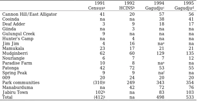
Aboriginal population counts from a range of sources between 1991 and 1995 are shown in Table 2.1 for each of these three residential categories together with population estimates for each individual Park community.
Clearly the greatest share of the regional population has consistently been in one of the many small communities dotted around the Park away from Jabiru town.
In 1991, almost three-quarters (74 per cent) of the region’s Aboriginal population were located in such places. By the end of 1995, this proportion had fallen quite markedly to 66 per cent. At the same time the proportion of the regional Aboriginal population resident in Jabiru had grown, initially due to an increase in the numbers at Manaburduma, and subsequently there appears to have been a marked increase in the numbers resident in Jabiru town suburbs. Because of this, the Aboriginal proportion of the usual resident Jabiru town population has almost doubled from 7.6 per cent in 1991 to 13.1 per cent in 1995.3
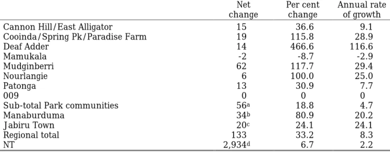
Using 1991 Census usual residence data as a base, the Aboriginal population of Kakadu is estimated to have grown at an annual rate of 8.3 per cent during the 1990s. This was almost four times higher than the rate of Aboriginal population growth recorded for the NT as a whole (Table 2.2).
In terms of the demographic components of this growth, data supplied by the ABS on the number of births and deaths among Aboriginal usual residents of the Park are available for the period 1991–94 only. These data suggest that the main cause of population growth has been net in-migration rather than natural increase.
Between 1991 and 1994 a total of 50 births to Aboriginal women from the region were recorded by the Registrar-General compared to 18 deaths among usual residents. This produces a net natural increase of 32 persons out of a total net increase for this period of 98, which means that net migration contributed 66 persons, or two-thirds of the net growth. The continuation of population growth into 1995 is also suggestive of a sustained level of net in-migration to the region.
Table 2.1. Aboriginal population counts and estimates: Kakadu National Park communities, 1991–95
1991 Censusa
1992 HCINSb
1994 Gagudjuc
1995 Gagudjud
Cannon Hill/East Alligator 41 20 57 56
Cooinda na na 38 41
Deaf Adder 3 9 18 17
Giinda na 3 na na
Gulungul Creek 9 na na na
Hunter’s Camp na 4 na na
Jim Jim 4 16 nae na
Mamukala 23 17 21 21
Mudginberri 62 60 129 135
Nourlangie 6 7 7 12
Paradise Farm 10 8 nae na
Patonga 42 72 53 55
Spring Peak 9 9 naf na
009 20 24 20 20
Park communities (310)g 249 343 354
Manaburduma na 42 72 76
Jabiru Town 102h na 83 103
Total (412)i na 498 533
Note: na = not available.
a. Unofficial unpublished pre-census estimates derived from Census Field Officer reports.
b. ATSIC HCINS.
c. Estimates of usual resident population from Gagudju Health visits, November.
d. Estimates of usual resident population from Gagudju Health visits, December.
e. Included in Cooinda estimate.
f. Included in Cooinda estimate.
g. Figure in brackets is the 1991 Census count for NT CD 031402 and not the sum of outstation pre-census estimates. This corresponds with the boundaries of Kakadu National Park (excluding Jabiru).
g. Combined 1991 Aboriginal usual residence count for Jabiru town and Manaburduma.
i. Figure in brackets is the sum of the 1991 Census usual residence count for Jabiru SLA and the place of enumeration count for NT CD 031402.
Table 2.2. Apparent population growth rates for Aboriginal communities in Kakadu National Park and Jabiru, 1991–95
Net change
Per cent change
Annual rate of growth
Cannon Hill/East Alligator 15 36.6 9.1
Cooinda/Spring Pk/Paradise Farm 19 115.8 28.9
Deaf Adder 14 466.6 116.6
Mamukala -2 -8.7 -2.9
Mudginberri 62 117.7 29.4
Nourlangie 6 100.0 25.0
Patonga 13 30.9 7.7
009 0 0 0
Sub-total Park communities 56a 18.8 4.7
Manaburduma 34b 80.9 20.2
Jabiru Town 20c 24.1 24.1
Regional total 133 33.2 8.3
NT 2,934d 6.7 2.2
Note: a. Using the 1991 Census count for CD 031402 as the base.
b. Using the 1992 HCINS estimate as the base.
c. Using the 1994 Gagudju Health estimate as the base.
d. Based on medium series projections (ABS 1996b).
As for growth rates in individual communities, these are also shown in Table 2.2 but care must be taken when interpreting the results because community-level population figures are estimates only and are based on variable criteria for determining usual residence. For example, growth rates for Park communities as a whole use the de facto census count for NT CD 031402 as the figure for the base year. In the calculations for Manuburduma and Jabiru town, de jure estimates from the 1992 HCINS and 1994 Gagudju Health Survey have been used as the base years.
Variable population size is also reflected in the different growth rates. For example, the highest growth appears to have occurred at Deaf Adder but this represents an increase to 17 people from a base of only three in 1991. In broad terms, all outstation communities, with the exception of Mumakala, 009 and perhaps Nourlangie, appear to have experienced locally significant increases in population in recent years. This is particularly so in Mudginberri, and to a lesser extent in Manuburduma, given their already relatively large numbers. The relatively high rate of growth in Jabiru town suburbs should also be noted.
The 1996 Census count
The 1996 Census count of Aboriginal people in the Kakadu region was not available at the time of compiling the report to the Aboriginal Project Committee of the KRSIS.
However, it is important to reflect on the results of the 1996 Census, not just for their intrinsic value in representing the most recently available official data, but also because they reveal population numbers that are substantially at odds with those reported in the initial KRSIS report. Basically, the 1996 Census results indicate a substantial decline since the 1991 Census both in the number of people counted in the Kakadu region as their place of enumeration and in the number of those whose usual residence was in the region.
Table 2.3. Aboriginal population by place of enumeration in the Kakadu region, 1991 and 1996
Collection district 1991 1996 Change
Net Per cent
Jabiru
NT CD 013801 54 75 21 38.9
NT CD 013802 16 27 11 68.7
NT CD 103803 62 3 -59 -95.2
Total 132 105 -27 -20.4
Park outstations
NT CD 031402 311 205 -106 -34.1
Total Kakadu 443 310 -133 -30.0
Source: 1996 Census of Population and Housing.
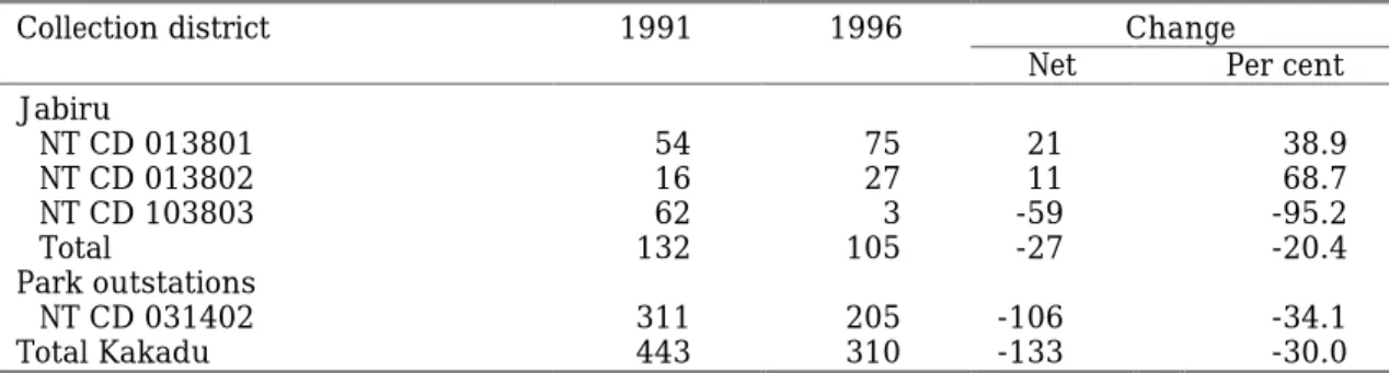
This is demonstrated in Table 2.3 which shows the number of Aboriginal people counted in the Kakadu region in 1991 and 1996. According to these figures the population fell by 30 per cent, from 443 to 310, representing a shift back towards the population levels of the early 1980s. Geographically, the decline was across the region with a population loss in Jabiru (of 20 per cent) and at outstations in Kakadu National Park (of 34 per cent). The reason for the decline in Jabiru was the almost complete loss of population from NT CD 103803 which is the CD within Jabiru that contains Manuburduma town camp.
Of course, the more appropriate population count for the region is that of usual residents and one reason for the lower place of enumeration count could be that usual residents of the region were away from the region in another census area
on census night. To assess the possible affect of such an occurrence, Table 2.4 compares the 1991 and 1996 usual resident populations of the region.
Table 2.4. Aboriginal population by place of usual residence in the Kakadu region, 1991 and 1996
SLA 1991 1996 Change
Net Per cent
Jabiru SLA 102 106 4 3.9
South Alligator SLA 305 221 -84 -27.5
Total 407 327 -80 -19.6
Source: 1996 Census of Population and Housing.
As noted earlier, the smallest geographic unit for place of usual residence data is the SLA level which presents a slight problem for analysis as the South Alligator SLA covers an area beyond the Kakadu region. Of the two collection districts within the SLA (NT CD 031401 and NT CD 031402), only the latter falls within Kakadu.
However, in 1991 there were no Aboriginal people counted in NT CD 031401 and in 1996 only 15. On this basis, it is assumed that the usual residence figures for the South Alligator SLA can be safely used as a proxy count for the Kakadu region.
Even with usual residence figures, the overall trend in population change is downwards with around 20 per cent fewer Aboriginal people indicated as usual residents of the Kakadu region. However, this decline was entirely due to a reduction in the population count at outstations since the population counted at Jabiru remained the same. The usual residence figure for Jabiru (106) is interesting because it is almost identical to the place of enumeration figure (105). This suggests that if the residents of Manuburduma were absent from Jabiru at census time then they were not picked up in any other census district either, at least not as usual residents of Jabiru. This raises two possibilities: either town camp residents were not counted at all or they indicated a change in their usual place of residence to somewhere outside of the Kakadu region. The latter prospect is suggested by the fact that the usual resident population at Kakadu outstations declined markedly.
With regard to the apparent fall in outstation residents, it may be significant that a total of 221 usual residents of this area did not answer the census question on Aboriginal origin (compared to only three in 1991). Since Aboriginal people comprise approximately half of the usual residents of Kakadu National Park it does seem likely that the decline in their numbers may have been due to this census error. At the 1991 Census, the question on Aboriginal origin was pre-ticked in the affirmative on remote area census forms but this was not the case in 1996. Whether this change in census method had any bearing on the increase in ‘not stateds’ is unknown but it is advanced here as a plausible explanation.
The indication from census data of a substantial decline in usual resident numbers is surprising in the face of the estimates of population growth presented in Tables 2.1 and 2.2. While some variation between these figures and census figures is to be expected given the different methodologies used, both the lower level of the census usual resident count and the counter trend towards fewer numbers, appear anomalous. In this context, it should be noted that discrepancies of this type between ABS and other counts of remote Aboriginal populations have been recorded elsewhere (Martin and Taylor 1996).
In summary, results from the 1996 Census count of Aboriginal people in the Kakadu region appear questionable. At the very least they raise an issue, identified by the ABS itself, regarding the utility of usual residence data for planning purposes compared to estimates of service populations (ABS 1996c). In a region such as Kakadu, with its highly mobile population, there is potential for pressure on
resources and infrastructure to be understated if an enumeration fails to adequately represent reality. In such a situation, it is advisable not to rely solely on one source of population data but to be guided by the indications of many.
Age and sex composition
Data on the age and sex of Aboriginal residents of Kakadu are available from the 1991 Census and from the population survey conducted by the Gagudju Health team in 1995 which obtained date of birth information for each individual. While census data identify these characteristics separately for the population counted at Manaburduma and in Jabiru town suburbs, they do not do this for usual residents nor do they identify individual outstations. However, the Gagudju Health Survey data do enable age and sex characteristics to be explored for each individual community. Such knowledge of the demographic structure of the population is vital in establishing rates for social indicators as well as in assessing health, housing, education, employment and training needs.
Table 2.5. Distribution of Aboriginal population by broad age group: Kakadu region, 1995 and Jabiru ATSIC Regional Council area and NT, 1991
Age group Kakadu Region Jabiru Regional
Council area NT
0–14 33.9 38.6 37.9
15–29 35.1 32.0 31.0
30–49 21.4 20.7 21.9
50+ 9.6 8.7 9.2
Total 100.0 100.0 100.0
Source: 1995 Gagudju Health Survey; 1991 Census of Population and Housing.
Overall, the age structure of the Aboriginal population is youthful with 33.9 per cent of the population under the age of 15 years, although this is somewhat less than the proportion of children in the Aboriginal populations of Jabiru Regional Council Area and the NT as a whole (Table 2.5). By comparison, the Kakadu region has a slightly higher proportion of young adults in the 15–29 age range, and to a lesser extent in the 30–49 age range, which might reflect the concentration of potential job opportunities in the region. As for older people aged 50 years and over, the Kakadu region has a slightly higher proportion (9.6 per cent) than its surrounding region but is very similar to the NT average.
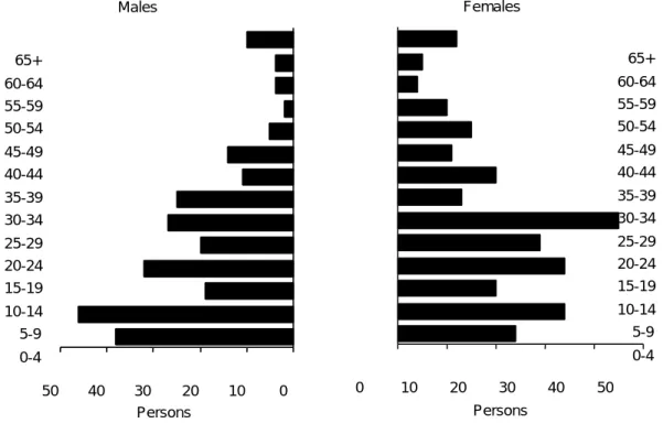
At 93 males per 100 females, the sex ratio in Kakadu is somewhat lower than in the surrounding ATSIC region (100.0) as well as compared to the Aboriginal population of the NT as a whole (96.0). In demographic terms, the reason for this is suggested in Figure 2.1 which shows the distribution of Aboriginal males and females by five-year age groups. Clearly males predominate in the younger ages at pre- and primary school age, but thereafter, and particularly in middle and old ages, females are more prominent.
The likelihood that this pattern reflects differential mortality is difficult to establish from official mortality data supplied by the ABS. Information regarding the number of deaths among Aboriginal usual residents of Jabiru SLA are available for the period 1981–94, whereas for the rest of the Kakadu region these data are only available from 1991 to 1994. This is because prior to 1991, data for the population of Kakadu National Park was included in the much larger Alligator Balance SLA.
Leaving aside any deficiencies in the system of recording usual residence in the certification of death, a complete picture of mortality for the whole of the regional population is therefore only possible for the period 1991–94. According to this information there were a total of 19 Aboriginal deaths, eight of these were males and
11 were females. Another source of mortality data is from key informants at the Gagudju Health team and this suggests a slightly higher overall mortality rate and much higher male mortality. Of the usual residents identified in the Gagudju population survey of November 1994, 14 had died over the 21-month period to August 1996 and all but two of these were males.
Figure 2.1. Age/sex pyramid of the Kakadu regional population, 1995 Males
0 10 20 30 40 50 0-4 5-9 10-14 15-19 20-24 25-29 30-34 35-39 40-44 45-49 50-54 55-59 60-64 65+
Persons
Females
0 10 20 30 40 50
0-4 5-9 10-14 15-19 20-24 25-29 30-34 35-39 40-44 45-49 50-54 55-59 60-64 65+
Persons
Source: Gagudju Health Survey, December 1995.
Dependency ratios
Measures of the potential economic implications of a given age structure are provided by a range of dependency ratios and these are shown in Table 2.6 for the Aboriginal population of Kakadu in 1996 and for the NT and Jabiru Regional Council area in 1991. The childhood dependency ratio is the simplest of these measures and expresses the number of children in the population (aged 0–14 years) as a ratio of the working-age population (aged 15–64) multiplied by 100. Obviously a ratio of 100 would indicate that the size of the two age groups is the same and that there is one person of working age for every child. A figure greater than 100 indicates more than one child to each person of working age, and less than 100 indicates less than one child to each person of working age. This provides an indication only of potential economic providers to dependants as it takes no account of the economically inactive. In Kakadu, the childhood dependency ratio was 55. This was much lower than the figure of 71 recorded for the Jabiru Regional Council Area in 1991 and is also below the NT average of 67. This means that the proportion of working-age adults to children is relatively high in Kakadu.
More refined measures of dependency incorporate some indication of the ability of working-age adults to support others. The childhood burden, for example, is defined as the ratio of the number of children to the number of employed persons.
Once again, a figure of 100 indicates parity and the results show that in Kakadu
there are 3.4 children to each employed adult which is higher than in the Jabiru ATSIC Regional Council area and the NT as a whole.
Table 2.6. Aboriginal dependency ratios for Kakadu, Jabiru Regional Council Area and NTa
Dependency ratio
Kakadu 1996
Jabiru Regional Council Area
1991
NT 1991
Childhood dependency 55 71 67
Childhood burden 342 272 226
Dependency ratio 306 392 312
Economic burden 760 571 475
Note: a. Calculated on the assumption that all Aboriginal children are economic dependents of Aboriginal adults.
Another measure is provided by the dependency ratio which represents the ratio of children and economically inactive persons to the labour force (those employed plus those receiving unemployment benefits). On this score, Kakadu is similar to the NT average of three dependents per economically active person.
Finally, the economic burden is a ratio of the number of children and economically inactive persons (including here the unemployed) to employed persons. This shows that in Kakadu for each employed Aboriginal person there are 7.6 other Aboriginal people not employed. This is far higher than in the surrounding region and close to double the NT average.
Population mobility
Aggregate population numbers for the Kakadu region have to be interpreted in the context of high rates of population mobility. This is due to the variable affect that mobility can have on population levels and the underlying problem that such movement poses for any clear definition of a usually resident group. Aside from permanent (long-term) movements of individuals in and out of the region, those who spend periods of time resident in the Park are also frequently mobile over the short term. As with remote Aboriginal communities across Australia generally, a considerable spatial range of movement exists extending from frequent inter- household shifts within the same community to intra-regional movement between communities and longer-range inter-regional movement, often to an urban centre (Taylor 1998). In each case, the extent of this mobility is defined spatially by a mix of social and economic factors with influences ranging from deaths in a community, the location of kinfolk, ceremonial activities, traditional utilisation of land resources, employment opportunities and the need to access services. In recent times, significant short-term redistribution of people also occurred (mostly to Park Ranger stations and Manuburduma) following the introduction of a $50 service fee for outstation residents by the Gagudju Association.
An important point to note is that a substantial gap often exists between the depiction of mobility by service providers and that recorded by standard census measures. Striking examples of this are found across much of remote Australia where very low rates of mobility are recorded by the census in areas such as Kakadu (Taylor and Bell 1996). This is despite the fact that survey data and the practical experience of service providers attest to the importance of frequent mobility in the daily, periodic and seasonal round of activities associated with Aboriginal social and economic life. While the 1991 Census identifies 96 Aboriginal people aged five years and over who were resident in Kakadu in 1991 but lived outside of the larger area of Alligator Balance SLA in 1986, a basic problem derives from the inability of such a fixed-period migration measure to capture the short-term and often circular
movement of many Aboriginal people. Indeed, this very movement of people between localities and households complicates the application of ABS usual place of residence criteria and does raise a question for SIA about who precisely is to be regarded as a Park resident.
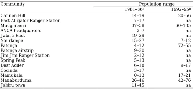
While the occurrence of frequent population movement is widely acknowledged, few published data are available regarding the extent and patterns of movement among the Kakadu population. Some indirect indication of the level of mobility is available from surveys of the Park population conducted by Altman (1988) in the early to mid 1980s. By comparing lists of individuals in each community compiled in 1982 against similar community lists for June 1986, a degree of compatibility was established for Park outstations such as Cannon Hill, Patonga, Deaf Adder, Spring Peak and Mudginberri, but for Jabiru East, Manaburduma and Jabiru town suburbs very little correspondence was found (Altman 1988: 185). This distinction between apparent greater continuity of residence in the Park outstation communities and higher population turnover in the more urban communities appears to have persisted to the present with most changes to the Gagudju Health population lists of 1994 and 1995 occurring in Manuburduma and Jabiru town.
Table 2.7. Variability in population levels: Kakadu Aboriginal communities, 1981–86 and 1992–95
Community Population range
1981–86a 1992–95b
Cannon Hill 14–19 20–56
East Alligator Ranger Station 7–17 na
Mudginberri 37–58 60–135
ANCA headquarters 2–7 na
Jabiru East 19–39 na
Nourlangie 15–37 7–12
Patonga 4–12 72–55
Patonga airstrip 9–30 na
Jim Jim Ranger Station 2–12 na
Spring Peak 5–13 na
Deaf Adder 6–18 9–17
Cooinda 3–17 na
Mamukala 0–13 17–21
Manaburduma 26–46 42–76
Jabiru town 11–45 na
Note: a. From Park surveys listed in Wellings 1987.
b. From 1992 ATSIC HCINS and Gagudju Health Survey 1995.
One consequence of mobility is that population levels in each community may fluctuate considerably over short periods of time to the extent that a de facto count in one month may not necessarily tally with a similar count in a following month.
Once again, some indication of the degree to which population levels may vary in each community is available from data collected by various surveys in the 1980s (Wellings 1987) and by the 1992 ATSIC HCINS and Gagudju Health estimates of 1995. These are shown in Table 2.7.
From a servicing point of view, the fact of frequent population shifts means that the ratio of clients to de facto regional population is invariably greater than one.
This produces what may be euphemistically referred to as a ‘service population’
which is inevitably higher than the population counted in the region at any given time. While this population can be shown to exist at a theoretical level, its actual size and composition in the Kakadu region remains indeterminate. Nonetheless, the notion of a population ‘pool’ that has links with the region and is variously resident
there has important consequences for planning adequate service delivery (Taylor 1996). Some scope for estimating the size and composition of this service population would be available by summarising basic demographic information from the numerous health records of non-usual resident Aboriginal clients held at Jabiru Health Centre.
For example, in assessing housing adequacy, overcrowding measures may need to consider not just those counted in a dwelling by a survey but also other usual residents who may be absent for a period of time as well as others who may utilise the dwelling from time to time. In terms of education requirements, aggregate statistics reveal the number of Aboriginal children enrolled and attending school at particular points in time, but it is not certain that these refer consistently to the same individuals. Given that children often accompany adults in their movements across, into and out of the region, the question arises as to which population school statistics refer. It seems likely that some mobile children may be overlooked as part of the regular school population. In this event who has responsibility for their education? In this context, it is interesting to note that the Gagudju Health team currently identifies a regular service population of some 530 individuals resident in the Park, and yet their patient records include many more than this in the category of intermittent visitors to the Health Centre. Under such circumstances, what constitutes the appropriate planning population? When calculating employment and unemployment rates for the region, which adults are to be considered as the pool of eligible job seekers? In this context, it is interesting to note that both the recent report to the Gunbang Action Group (d’Abbs and Jones 1996) and the Kakadu/West Arnhem Employment, Education and Training Group refer to the population of Kakadu and western Arnhem Land.
Regional pattern of mobility
Some idea of the spatial extent of social interaction involving the Kakadu region is provided by the ethnographic record and is available indirectly from administrative data. At the ethnographic level, it is known that elements of the original population of the region were gradually dispersed to adjacent areas following initial contact with Europeans and as a consequence of the pressures and attractions of economic development and the influence of government and mission officials (Keen 1980a; Levitus 1995).
The extent of this diaspora with social and traditional links with the Kakadu region is partly indicated by the current spatial distribution of the Gagudju Association membership which shows that 52 per cent are located outside the Park, mostly at nearby Gunbalunya (Oenpelli). This represents a reversal of a trend established by Altman (1983: 121, 1988: 187–8) who calculated that between 50 and 60 per cent of the Aboriginal population in Kakadu were members of the Association in 1982 and that this had declined to only 35 per cent by 1986.
Another partial indication of the extra-regional spread of affiliated population is provided by cross-checking the residential location of adults on the Gagudju Health list of Park residents in October 1994 with the electoral roll published for the NT election in May of the same year. Both of these lists were constructed on the basis of usual place of residence criteria. Of the 280 adults of voting age on the Gagudju Health list, all but 82 were present on rolls for the Top End electorates of Goyder, Arafura or Arnhem.4 Of the 198 adults on both lists, only half (51 per cent) were recorded at the same location within the Park. A few (11 per cent) were still recorded within the Park but at a different location, while more than one-third (38 per cent) were recorded at a location outside of the Park. Of this latter group, 41 per cent were in localities to the east of the Park, mostly at Gunbulunya and its outstations; 28 per cent were in localities to the south of the Park, mostly at Kybrook
Farm and to a lesser extent Barunga and Eva Valley; and the remainder were in assorted locations such as Cobourg Peninsula and Warruwi, Humpty Doo and the Tiwi Islands. This pattern of distribution is consistent with the distribution of the Gagudju membership.
3. Labour force status
Provisions for the employment and training of Aboriginal people within Kakadu National Park are specified in agreements between the NLC and the ANPWS, and the NLC and the Commonwealth in 1978. Also available to Aboriginal people over the past two decades have been the full range of both mainstream and Aboriginal- specific labour market and training programs offered Department of Employment, Education, Training and Youth Affairs (DEETYA),5 as well as opportunities developed by Aboriginal and non-Aboriginal private sector interests.
The first of the agreements mentioned above was signed between the NLC and the Director of ANPWS and set out terms and conditions for the lease of Aboriginal land in Kakadu Stage 1. Of particular interest are the provisions for employment and training of local Aboriginal people. Paragraph 4(a) guaranteed to set up a program for training reasonable numbers of local Aborigines in skills necessary to enable them to assist in the management and control of the Park. Paragraph 4(b) undertook to engage as many of the traditional owners as practicable to provide services to the Director and in relation to the Park. Paragraph 4(c) stated that all practicable steps would be undertaken to adjust working hours and conditions to the needs and culture of Aboriginal people employed in the Park.
The second agreement was entered into pursuant to s.s.44(2) of ANL. This set out terms and conditions under which mining at Ranger could proceed. Paragraph 12.1(a) required RUM to ensure that as many Aboriginal people as practicable were employed where those Aboriginal people were capable of carrying out in a satisfactory manner the particular work required. RUM was also required to establish an ‘operator training scheme’ and to adjust working hours and conditions to suit the needs and culture of Aboriginal employees.
Apart from the focus on employment in quite different economic sectors, the main variation between these two agreements was that the former referred to traditional Aboriginal owners of land and provided for renegotiation after ten years, while the latter referred only to Aboriginal people and was valid for the life of the mine.
Since the commencement of mining, the construction of Jabiru and the creation of a national park with associated tourist developments, the Kakadu region has become relatively well endowed in job opportunities compared to most other remote regions of the NT. While overall employment levels have fluctuated somewhat in line with the fortunes of RUM, the level and range of economic activity is such that opportunities for employment within the region have remained buoyant.
However, the crucial issue from the point of view of SIA is the extent to which Aboriginal people, and particularly local Aboriginal people, have gained access to this expanding labour market.
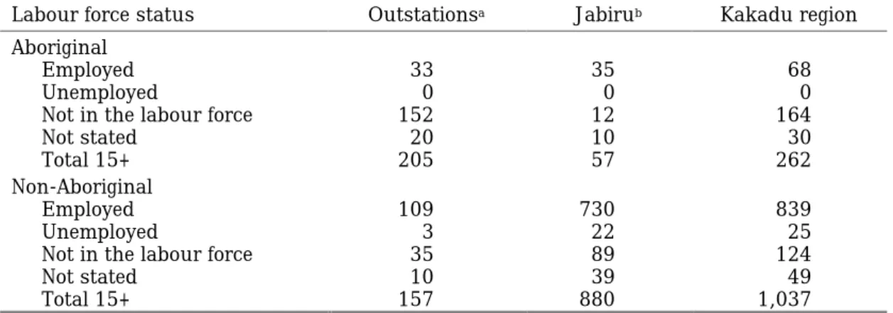
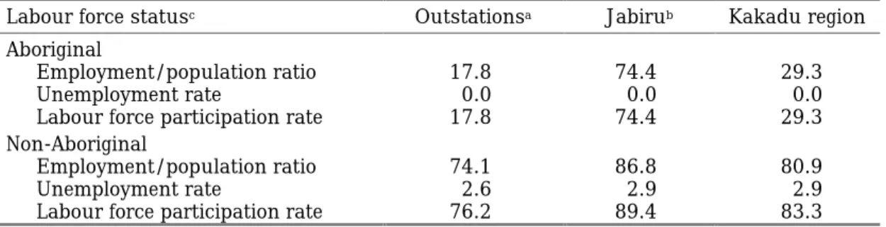
Aboriginal/non-Aboriginal labour force status 1991
The distribution of Aboriginal and non-Aboriginal residents of the region by labour force status is shown in Table 3.1 using 1991 Census data. In Table 3.2, these data are converted into rates.