Landcom Norwest Metro Station Site Detailed Site Investigation
25 to 31 Brookhollow Avenue Norwest NSW 5 July 2021 57518/138923 Rev 1 JBS&G Australia Pty Ltd
ATTACHMENT N
Landcom Norwest Station Site Detailed Site Investigation
25 to 31 Brookhollow Avenue
Norwest NSW
5 July 2021
57518/138923 Rev 1
JBS&G Australia Pty Ltd
©JBS&G Australia Pty Ltd | 57518/138923 Rev 1 iii
Table of Contents
Abbreviations ... viii
Executive Summary ... 1
1. Introduction ... 2
1.1 Introduction and Background ... 2
1.2 Objective... 2
1.3 Scope of Work ... 2
1.4 Summary of Recent Works and Public Domain Information ... 3
2. Site Condition and Surrounding Environment ... 5
2.1 Site Identification ... 5
2.2 Site Condition ... 5
2.2.1 September 2019 ... 5
2.2.2 June 2021 ... 6
2.3 Surrounding Land Uses ... 6
2.4 Topography... 6
2.5 Geology and Soils ... 7
2.6 Acid Sulfate Soils... 7
2.7 Hydrology ... 8
2.8 Hydrogeology ... 8
2.9 Meteorology ... 9
3. Site History ... 11
3.1 Historical Titles ... 11
3.2 Aerial Photographs ... 11
3.3 EPA Records ... 11
3.4 Department of Defence ... 12
3.5 Australian and NSW Heritage Register ... 12
3.6 Planning Certificates ... 12
3.7 Summary of Site History and Integrity Assessment ... 13
4. Previous Investigations ... 14
5. Conceptual Site Model ... 15
5.1 Potential Areas and Substances of Environmental Concern ... 15
5.2 Potentially Contaminated Media ... 15
5.3 Potential for Migration ... 15
5.4 Potential Exposure Pathways ... 16
5.5 Receptors ... 16
5.6 Preferential Pathways ... 16
©JBS&G Australia Pty Ltd | 57518/138923 Rev 1 iv
6. Sampling Analysis and Quality Plan ... 18
6.1 Data Quality Objectives ... 18
6.1.1 State the Problem ... 18
6.1.2 Identify the Decision ... 18
6.1.3 Identify Inputs to the Decision ... 18
6.1.4 Define the Study Boundaries ... 19
6.1.5 Develop a Decision Rule ... 19
6.1.6 Specify Limits of Decision Error... 20
6.1.7 Optimise the Design for Obtaining Data ... 22
6.2 Field Investigation Methodology ... 23
6.2.1 Soil ... 23
6.2.2 Groundwater ... 24
6.2.3 Soil Vapour ... 24
6.3 Laboratory Analysis ... 25
7. Assessment Criteria ... 27
7.1 Regulatory Guidelines ... 27
7.2 Assessment Criteria ... 27
7.2.1 Soil Criteria ... 27
7.2.2 Water Assessment Criteria ... 28
7.2.3 Soil Vapour Assessment Criteria ... 28
8. Quality Assurance Quality Control... 30
8.1 QA/QC Discussion ... 31
8.1.1 Precision ... 31
8.1.2 Accuracy ... 31
8.1.3 QA/QC Conclusions ... 31
9. Results ... 32
9.1 Field Observations ... 32
9.1.1 Lithology and Soil Observations ... 32
9.1.2 Groundwater Field Observations ... 32
9.2 Laboratory Analysis Results ... 33
9.2.1 Soil Contaminant Analytical Results... 33
9.2.2 Asbestos Identification ... 33
9.2.3 Soil Vapour Field Screening ... 34
9.2.4 Soil Vapour Analytical Results ... 34
10. Discussion ... 35
10.1 Potential Risks to Future Onsite Receptors ... 35
10.2 Background Contamination ... 35
10.3 Chemical Mixtures ... 35
©JBS&G Australia Pty Ltd | 57518/138923 Rev 1 v
10.4 Aesthetic Issues ... 35
10.5 Potential Offsite Migration of Contaminants ... 35
10.6 Site Management Strategy ... 36
11. Conclusions and Recommendations ... 37
12. Limitations ... 38
©JBS&G Australia Pty Ltd | 57518/138923 Rev 1 vi
List of Tables
Table 2.1: Summary Site Details ... 5
Table 2.2 Registered Groundwater Bore Search ... 9
Table 5.1: Areas of Environmental Concern and Associated Contaminants of Potential Concern ... 15
Table 6.1: Summary of Decision Rules ... 19
Table 6.2: Summary of Quality Assurance / Quality Control Program ... 21
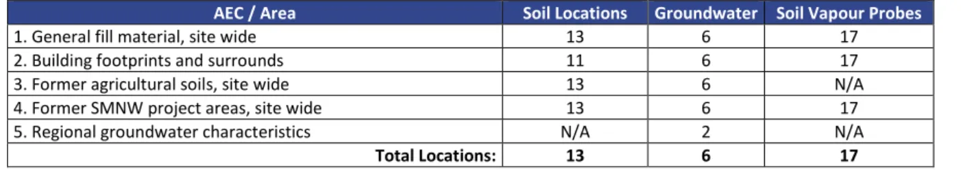
Table 6.3: Investigation Location Summary ... 23
Table 6.4: Analytical Schedule ... 26
Table 9.1 Derived EIL criteria (all units in mg/kg) ... 28
Table 8.1 QA/QC Results Summary ... 30
Table 9.1A Bottom Depth of Encountered Lithology in Monitoring Wells (m bgl) ... 32
Table 9.2 Summary of Soil Analytical Results ... 33
Table 9.3 Summary of Soil Vapour Screening ... 34
Table H.1 Historical Aerial Photograph Review ... 50
List of Figures
Figure 1 Site Location Figure 2 Site Layout
Figure 3 Areas of Environmental Concern
Figure 4A Soil Sample and Groundwater Well Locations Figure 4B Soil Vapour Sample Locations
©JBS&G Australia Pty Ltd | 57518/138923 Rev 1 vii
Tables and Appendices
Table A Soil Analytical Results (Land Use Suitability)
Table B Soil Vapour Analytical Results (Land Use Suitability) Appendix A Site Survey
Appendix B Photographic Log Appendix C Soil Group Factsheet
Appendix D Acid Sulfate Soil Risk Map (SEED) Appendix E Section 10.7 (2&5) Certificates Appendix F Registered Monitoring Wells
Appendix G Current and Historical Land Title Records Appendix H Historical Aerial Photographs
Appendix I EPA Searches
Appendix J Department of Defence Searches Appendix K Heritage Data Base Searches Appendix L Laboratory Analytical Reports
Appendix M Quality Assurance / Quality Control Summary Appendix N Decontamination and Calibration Records Appendix O Borehole Logs and Soil Vapour Screening Sheets Appendix P Statistical Assessment
©JBS&G Australia Pty Ltd | 57518/138923 Rev 1 viii
Abbreviations
Term Definition
ACM Asbestos Containing Material
AHD Australian Height Datum
ASS Acid Sulfate Soils
AST Aboveground Storage Tank
bgl Below Ground Surface
BTEX Benzene, Toluene, Ethylbenzene, Xylenes
CEC Cation Exchange Capacity
COC Chain of Custody
COPC Contaminants of Potential Concern Council The Hills Shire Council
CSM Conceptual Site Model
DO Dissolved Oxygen
DP Deposited Plan
DQI Data Quality Indicator
DQO Data Quality Objective
EC Electrical Conductivity
Eh Redox Potential
EIL Ecological Investigation Levels Envirolab Envirolab Services Pty Ltd
EPA NSW Environmental Protection Authority ESL Ecological Screening Levels
Eurofins Eurofins MGT
GME Groundwater Monitoring Event
Ha Hectare
HIL Health Investigation Levels
HSL Health Screening Levels
JBS&G JBS&G Australia Pty Ltd
LCS Laboratory Control Sample
LEP Local Environmental Plan
LNAPL Light Non-Aqueous Phase Liquid
LOR Limit of Reporting
NAPL Non-Aqueous Phase Liquid
NATA National Association of Testing Authorities
OCP Organochlorine Pesticides
OEH Office of Environment and Heritage PASS Potential Acid Sulfate Soils
PAH Polycyclic Aromatic Hydrocarbons
PARCCS Precision, Accuracy, Representativeness, Comparability, Completeness and Sensitivity
PCB Polychlorinated Biphenyls
PFAS Per and Polyfluoroalkyl Substances
PID Photo-ionisation Detector
ppm Parts Per Million
QA/QC Quality Assurance / Quality Control RPD Relative Percent Difference
SWL Standing Water Level
SAQP Sampling, Analysis and Quality Plan TCLP Toxicity Characteristic Leaching Procedure
TPH Total Petroleum Hydrocarbons
TRH Total Recoverable Hydrocarbons
UCL Upper Confidence Limit
UST Underground Storage Tank
VOC Volatile Organic Compounds
©JBS&G Australia Pty Ltd | 57518/138923 Rev 1 1
Executive Summary
JBS&G Australia Pty Ltd has been engaged by Landcom (the client) to undertake a contamination assessment of the property located 25 to 31 Brookhollow Avenue, Norwest, NSW (the site). The site is located on the corner of Norwest Boulevarde and Brookhollow Avenue (Figure 1) and occupies an approximate areal footprint of 9402 m2, as shown on Figure 2. The site is legally identified as Lot 71 in Deposited Plan 1252765.
The Planning Proposal incorporates a preliminary development layout. The development layout comprises two multi-storey buildings, surrounded by ground level public domain. A two level in- ground basement is proposed across the majority of the site footprint to a depth of approximately 7 m below ground level (bgl), underlying the buildings and the public domain.
The site is proposed to be developed for a combination of commercial uses: office space, retail, business services, and short term accommodation, consistent with the current zoning of “B7- Business Park” under The Hills Local Environmental Plan 2019 (Council 20191). The Planning Proposal and development layout are consistent with generic landuse scenarios as described in NEPC (2013) for commercial/industrial with potentially sensitive land uses (child care centres).
JBS&G has prepared a land contamination assessment report in accordance with the requirements of the State Environmental Planning Policy No 55 – Remediation of Land (SEPP55) to assess whether the site is suitable, or can be made suitable for the proposed land uses. This investigation has been completed in accordance with guidelines made or approved by the New South Wales Environment Protection Authority. Further reference has been made to national and state environmental
databases pertaining to potentially consequential background acid sulfate soils conditions at the site.
The scope of work undertaken for the investigation included assessment of historical site use via desktop review of available records, an inspection of the site and surrounding land uses,
implementation of a field investigation program including sampling of potentially contaminated media representative of site conditions, laboratory analysis of selected samples for identified contaminants of potential concern, assessment of data against relevant EPA endorsed guidance with respect to potential land uses and preparation of a land contamination assessment report.
Based on the scope of investigation undertaken, and in accordance with the limitations in Section 12, the following conclusions and recommendations are provided:
• No significant site contamination issues were identified by the investigation and as such, the site is considered suitable for the proposed commercial development, inclusive of
potentially sensitive (i.e. child care centre) land uses;
• No potential for the presence of acid sulfate soil was identified in the desktop assessment undertaken for this investigation. During site sampling, no indicators of ASS were observed within sampled material. On this basis, no management for the potential presence of ASS is required during or following redevelopment of the site; and
• It is recommended that typical management strategies are implemented during
redevelopment to address the potential presence of any unexpected finds, which may be suitably documented within a construction environmental management plan (CEMP) framework.
1 The Hills Local Environmental Plan 2019. The Hills Shire, amended 23 June 2021, Council 2019
©JBS&G Australia Pty Ltd | 57518/138923 Rev 1 2
1. Introduction
1.1 Introduction and Background
JBS&G Australia Pty Ltd (JBS&G) has been engaged by Landcom (the client) via National Project Consultants Pty Ltd (NPC) to undertake a contamination assessment of the property located 25 to 31 Brookhollow Avenue, Norwest, NSW (the site). The site is located on the corner of Norwest
Boulevarde and Brookhollow Avenue (Figure 1) and occupies an approximate areal footprint of 9402 m2, as shown on Figure 2. The site is legally identified as Lot 71 in Deposited Plan (DP) 1252765.
It is understood that Landcom is pursuing a Local Environment Plan (LEP) amendment via a Planning Proposal. A Land Contamination Report is required to be submitted to the NSW Department of Planning, Industry and Environment (DPIE) to satisfy the requirements of State Environmental Planning Policy No 55 – Remediation of Land (SEPP55) in support of the planning proposal.
The Planning Proposal incorporates a preliminary development layout. The development layout comprises two multi-storey buildings, surrounded by ground level public domain. A two level in- ground basement is proposed across the majority of the site footprint to a depth of approximately 7 m below ground level (bgl), underlying the buildings and the public domain.
The site is proposed to be developed for a combination of commercial uses: office space, retail, business services, and short term accommodation, consistent with the current zoning of “B7- Business Park”. The Planning Proposal and development layout are consistent with generic landuse scenarios as described in NEPC (2013) for commercial/industrial with potentially sensitive land uses (child care centres).
JBS&G has undertaken this detailed site investigation (DSI) to assess whether the site is suitable for the proposed land uses. This DSI has been completed in accordance with guidelines made or approved by the New South Wales (NSW) Environment Protection Authority (EPA). Further reference has been made to national and state environmental databases pertaining to potentially consequential background acid sulfate soils (ASS) conditions at the site, as guided by information presented within ASSMAC (19982) guidelines.
1.2 Objective
The objectives of the DSI were to characterise potential contamination at the site, and to draw conclusions regarding the suitability of the site for the proposed landuses, or to make
recommendations to enable such conclusions to be made.
1.3 Scope of Work
The following scope of works was undertaken:
• A desktop review of available site history information, including:
o Review of environmental assessment reports, relating to the site and surrounding area, as hosted on readily accessible planning websites;
o Council Planning certificates obtained for the site;
o Historical and current land title records;
o Historical aerial photographs obtained from the Department of Lands;
o Publicly available heritage records held by the Department of Planning, Industry and Environment and Council, where readily available;
2 Acid Sulfate Soil Manual. Acid Sulfate Soil Management Advisory Committee, August 1998, ASSMAC 1998.
©JBS&G Australia Pty Ltd | 57518/138923 Rev 1 3
o Records of environmental incidents, former environmental licences, or contaminated land notices or notifications, as held by the EPA;
o Department of Defence records; and
o Licensed groundwater bores present within a 1.5 km radius of the site available on the online NSW Natural Resources Atlas;
• Review of the environmental setting, including a review of topography, geology, hydrology, hydrogeology and meteorology of the site and surrounding areas;
• A detailed site inspection to identify potential areas of environmental concern (AECs) and confirm desktop findings;
• Development and documentation of a conceptual site model (CSM) based on the available information;
• Development and documentation of the SAQP, with data quality objectives (DQOs) for the DSI in accordance with relevant EPA guidelines;
• Execution of a field investigation program comprising sampling of soil, groundwater and soil vapour at relevant locations across the site;
• Analysis of selected samples for a range of COPCs;
• Comparison of collected data against regulator published / endorsed investigation criteria to facilitate an assessment of land use suitability; and
• Preparation of this DSI report in general accordance with relevant EPA guidelines.
1.4 Summary of Recent Works and Public Domain Information
Prior to this assessment two development applications for major civil construction and infrastructure works associated with the Sydney Metro Northwest (SMNW) Project have previously been approved and implemented within and adjacent to the site. Details of these previously approved works are provided as follows:
• North West Rail Link Major Civil Construction Works (Critical State Infrastructure Project – SSI-5100) – including major earthworks, tunnel/station excavations, and aboveground infrastructure; and
• North West Rail Link – Stations, Rail Infrastructure and Systems (Critical State Infrastructure Project – SSI-5414) – construction and operation of stations and wider precincts, services facilities and rail infrastructure.
Based on review of information presented in the public domain, it is understood that works which occurred at the site are subject to a range of development management plans, including:
• Construction Environmental Management Plan. Northwest Rapid Transit Project Integrated Management System dated 12 October 2017, NRT (2017a);
• Construction Soil and Water Management Plan. Northwest Rapid Transit Project Integrated Management System dated 11 October 2017, NRT (2017b); and
• Construction Spoil Management Plan. Northwest Rapid Transit Project Integrated Management System dated 11 October 2017, NRT (2015).
Based on communications with the client and review of Nearmap imagery discussed further in Section 3.2, it is understood that works which occurred at the site under SSI-5100 and SSI-5414 comprised construction staging, material importation, material export and water treatment. JBS&G
©JBS&G Australia Pty Ltd | 57518/138923 Rev 1 4 has been advised that bulk materials were not imported to the site and placed permanently, with current site surfaces approximately as they had been prior to SMNW project works.
©JBS&G Australia Pty Ltd | 57518/138923 Rev 1 5
2. Site Condition and Surrounding Environment
2.1 Site Identification
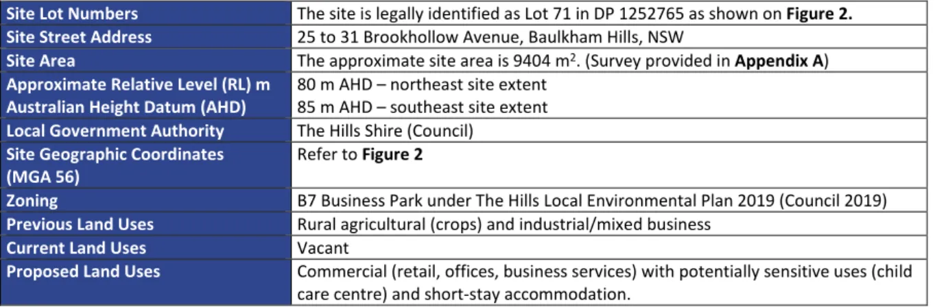
The location of the site is shown on Figure 1. The current layout is shown in Figure 2. Site identification details are provided in Table 2.1. A Survey of the Site 1 boundary is provided in Appendix A.
Table 2.1: Summary Site Details
Site Lot Numbers The site is legally identified as Lot 71 in DP 1252765 as shown on Figure 2.
Site Street Address 25 to 31 Brookhollow Avenue, Baulkham Hills, NSW
Site Area The approximate site area is 9404 m2. (Survey provided in Appendix A) Approximate Relative Level (RL) m
Australian Height Datum (AHD) 80 m AHD – northeast site extent 85 m AHD – southeast site extent Local Government Authority The Hills Shire (Council)
Site Geographic Coordinates
(MGA 56) Refer to Figure 2
Zoning B7 Business Park under The Hills Local Environmental Plan 2019 (Council 2019) Previous Land Uses Rural agricultural (crops) and industrial/mixed business
Current Land Uses Vacant
Proposed Land Uses Commercial (retail, offices, business services) with potentially sensitive uses (child care centre) and short-stay accommodation.
The site comprises one approximately rectangular parcel of land abutting Norwest Station, on the corner of the Norwest Boulevard and Brookhollow Avenue intersection.
2.2 Site Condition 2.2.1 September 2019
The site was inspected on the 25 September 2019 by Rohan Hammond, an environmental consultant trained and experienced in the identification of potential contamination sources. A recent site survey is provided in Appendix A. A photographic log is presented in Appendix B and relevant photographs referenced within the following description.
The site is secured from public access by a combination of wooden hoarding and chain link fences (Photographs 1 to 8). The site appeared to have been subject to cut and fill, associated with a former commercial structure, to form flat site surfaces.
At the time of the site inspection the land was generally level. The land had been levelled at a previous juncture with Brookhollow Avenue built atop a batter slope which formed the south eastern boundary of the site (Photographs 8, 9, 15 and 18). Small stockpiles (<10 m3 total) of apparently reworked natural material were observed on the southeast batter.
Approximately half of the site surfaces were covered by concrete hardstands, limited areas of asphaltic pavements southeast of the former northwest warehouse footprint were also observed.
The balance of the site comprised exposed soil at the ground surface, characterised as a mixture of fill materials including imported igneous gravel and possibly site won soil/tunnel spoil. Much of the level ground surface was covered with a bituminous black material, possibly applied as a dust suppressant during occupation of the site by Metro rail contractors. Building rubble was visible around the site including timber, brick, concrete, plastic, bolts and screws along with excavated material. The asphalt and parts of the concrete had painted lines indicative of locations for racking within a warehouse.
A standpipe was located on the northern edge of the northeast building footprint and upon inspection was recognised as a geotechnical monitoring bore.
©JBS&G Australia Pty Ltd | 57518/138923 Rev 1 6 Two in-ground stormwater drainage pits were observed between the former building footprints. It was unclear if these were here prior to demolition or if they were installed to direct water run-off during Metro Norwest construction activities. Both stormwater drains had been silt-fenced.
Several healthy trees lined the fence along the south eastern border of the site, their size and age indicating that they were there prior to demolition of the warehouses and commencement of the Metro construction activities.
No storage of bulk chemicals, wastes, odours, staining or the presence of hazardous building material were observed on site.
2.2.2 June 2021
A supplementary site inspection was undertaken on 23 June 2021 by Mitchell Hodgins, an
environmental consultant trained and experienced in the identification of potential contamination.
The supplementary site inspection was undertaken to evaluate potential changes in site features/land uses since the previous assessment activities in September 2019.
Supplementary photographs of the site are provided in Appendix B (Photographs 33 to 38). As relevant to the potential for contamination to exist at the site, no material changes to the site condition were identified.
2.3 Surrounding Land Uses
The assessment area was situated within an industrial precinct, with surrounding land uses identified as follows:
• Northeast – The site was bound to the northeast by a business park which included a range of commercial premises (offices, electrical/data wholesalers and a restaurant);
• Northwest – The site was bound to the northwest by Norwest Station, across which was Norwest Boulevard and a Shell service station with an attached car wash;
• Southeast – Brookhollow Avenue abutted the southeast boundary, followed by commercial warehouse type structures including an Australia Post facility and a metal fabrication factory (28 Brookhollow Avenue, 40 m from the site boundary); and
• Southwest – Norwest Boulevard abutted the southwest of the site, across which was a large church, parkland and carpark.
A metal fabrication business was located adjacent to the entrance of the site across Brookhollow Avenue. A large electrical transformer was located 1 m outside the northern fence of the site.
The local area is noted to have a history of common activities comprising primarily of commercial and industrial businesses, agriculture and low density residential uses. Internet searches indicated that a dry cleaning company was listed at a previous address on Brookhollow Avenue, however investigation into the origin of this listing did not suggest that a dry cleaning facility had ever existed within close vicinity to the site. The closest environmental receptor is Strangers Creek 200 m north of the site, as discussed further in Section 2.7.
2.4 Topography
Review of the Spatial Information Exchange Viewer, LPI (20154) regional topographic map indicated that the site is in a region characterised by gently undulating landforms. The site is located mid- slope on a northwest facing slope that falls overall toward Strangers Creek to the north of the site.
4 Spatial Information Exchange Viewer. NSW Land and Property Information, Accessed 13 August 2018, https://maps.six.nsw.gov.au/;
©JBS&G Australia Pty Ltd | 57518/138923 Rev 1 7 The JBS&G site inspection confirmed that the land surrounding the site graded downward on an approximate southeast to northwest orientation. The majority of the central and northern site portions were level as a result of historical excavation and filling associated with the former commercial development at the site.
2.5 Geology and Soils
Reference to the online ESPADE 2.0 tool hosted by the NSW Office of Environment and Heritage (OEH 20185) and the 1:100 000 Geological Series Sydney Geological Survey of NSW Sheet 9030 (DMR 19916) indicates that the site is present within the following natural geological and soil landscapes:
• Geology: Wianamatta Group – The soil landscape is underlain by Wianamatta group Ashfield Shale and Bringelly Shale formations. The Ashfield Shale consists of laminate and dark grey shale. Bringelly Shale, calcareous claystone and laminate. Between these two shale members is the Minchinbury Sandstone consisting of fine to medium-grained lithic quartz sandstone.
• Landscape: the site is within an area of low rolling to steep low hills with a local relief of 50 120 m and slopes of 5 – 20%. Convex narrow (20 – 300 m) ridges and hillcrests grade into moderately inclined side slopes with narrow concave drainage lines. Moderately inclined slopes of 10 – 15% are the dominant landform elements.
• Soils: ‘Luddenham Residual Soils’ – shallow dark podzolic soils or massive earthy clays on crests; moderately deep red podzolic soils on upper slopes; moderately deep yellow podzolic soils and prairie soils on lower slopes and drainage lines.
• Limitations – Water erosion hazard, localised steep slopes, localised mass movement hazard, localised shallow soils, localised surface movement potential; localised impermeable highly plastic subsoil, moderately reactive.
The soil group fact sheet is presented in Appendix C.
2.6 Acid Sulfate Soils
DLWC (1998), states that acid sulfate soils (ASS) are likely to be located in coastal lowlands up to about 10 m AHD. No risk map for the area encompassing the site was provided as part of the acid sulfate soil risk map series, DLWC (1998), typically indicating that such conditions have not been identified based on regional mapping of geology and soil (as discussed in Section 2.5).
Review of accessible data using the SEED tool, hosted by NSW OEH (20187) indicates the area occupied by the site has not been required to be assessed for the presence of ASS based on the outcomes of a preliminary evaluation. A printout of the risk map surrounding the site is presented in Appendix D. Such sites are by default characterised as “no known occurrence”, being defined as areas where land management activities are not likely to be affected by ASS materials.
Section 10.7 (2&5) planning certificates are included in Appendix E. The certificates do not identify the site as being subject to any policies relating to ASS.
Review of the geographical and topographical location of the site, in addition to the geological conditions identified at the site, has indicated that there is no appreciable risk of ASS occurrence in natural residual soils and/or rock at the site. On this basis, there is no further requirement for consideration of ASS conditions and/or management of such during future ground disturbance activities.
5 ESPADE 2.0. NSW Office of Environment and heritage, Accessed 13 August 2018, OEH 2018;
6 1:100 000 Penrith Geological Map Sheet 9030 Edition 1. Department of Mineral Resources, Published 1991, DMR 1991
7 Sharing and Enabling Environmental Data (SEED). https://www.seed.nsw.gov.au/ accessed 4 September 2018;
©JBS&G Australia Pty Ltd | 57518/138923 Rev 1 8 2.7 Hydrology
The nearest surface water receptor is Strangers Creek located approximately 200 m north of the northern site corner. Strangers Creek flows into Cattai Creek, located approximately 7.1 km to the north of the site, which in turn discharges into the Hawkesbury River approximately 24.9 km to the north of the site.
The current site condition, as described in Section 2.2, is characterised by graded surfaces.
Approximately 50 % of the site surfaces are sealed asphaltic/concrete hardstands which capture and direct overland water flow towards installed stormwater infrastructure, ultimately discharging to the municipal stormwater system. The remaining site areal footprint comprises unsealed exposed soils and gravel fill, most of which appeared to have been imported to the site as part of the SMNW works. It is anticipated that rainfall landing on unsealed areas would typically be directed towards existing onsite silt traps, with minor percolation into underlying soils.
Review of the site history as discussed in Section 3.2 indicates that a former drainage line
intersected the southwest corner of the site and meandered towards Strangers Creek to the north of the site. This feature was not observed during the site inspection and has likely been filled during development of the site for the former commercial land use.
2.8 Hydrogeology
As discussed in Section 2.5, the site lies within an environment characterised by Luddenham Residual Soils overlying Ashfield Shale. Two relevant groundwater systems are anticipated to operate in the vicinity of the site area:
• A shallow unconfined aquifer system within the unconsolidated soils of the Luddenham Residual Soils; and
• A deeper unconfined to semi-confined groundwater system resident in primary and secondary porosity of the Ashfield Shale.
Registered groundwater bore information was obtained from the NSW Department of Primary Industries groundwater mapping tools (NSW DPI 20188) (Appendix F). A review of the registered bore information indicated that there were 5 registered bores within a 500 m radius of the site. One bore was located on site, with the four others located north of Norwest Boulevard. Relevant details of registered bores have been summarised in Table 2.2.
8 Groundwater Monitoring Overview Map. NSW Department of Primary Industries, 2015 Http://allwaterdata.water.nsw.gov.au/water.stm Accessed 14 September 2019
©JBS&G Australia Pty Ltd | 57518/138923 Rev 1 9
Table 2.2 Registered Groundwater Bore Search
Bore ID Use Property Standing Water Level (m bgl) [Water Bearing Zones]
Well
Depth (m) Encountered Geology Comments GW107581 Monitoring On site - 27.48 Sandy clay to 3.9 m, shale to 18.34 m
overlying sandstone to 27.48 m.
GW111241 Monitoring SP 72831, Norwest Boulevard
- 8.00 Shallow fill to 0.4 m, gravel to 1.10 m overlying shale to 8.00 m.
GW111242 Monitoring Lot 2 DP1213272, Norwest Boulevard
- 8.30 Shallow fill to 1.40 m overlying shale to 8.30 m.
GW111243 Monitoring Lot 2 DP1213272, Norwest Boulevard
- 8.40 Shallow fill to 1.20 m, clay to 1.80 m overlying shale to 8.40 m.
GW111244 Monitoring Lot 2 DP1213272, Norwest Boulevard
- 8.10 Shallow fill to 0.20 m, clayey sand to 1.50 m overlying shale to 8.10 m.
Explanatory notes of Geological Survey of NSW Sheet 9030 (DMR 19919) state that the permeability of intact shale within the vicinity of the site is generally low.
A review of PB (201510), prepared for the SMNW project Norwest site, has provided the following information regarding the hydrogeological setting of the area surrounding the site. Perched groundwater present at approximately 6 m bgl within shale. Groundwater was reported to be present at approximately 14 m below the ground surface within sandstone and the base regional groundwater unit was within Hawkesbury Sandstone at up to 130 m bgl.
Monitoring undertaken as part of the SMNW Project indicates the groundwater to be moderately saline, iron-rich, turbid and rich in heavy metals (nickel, copper and zinc) at concentrations which exceed published drinking water criteria. Groundwater testing adjacent to the Norwest metro station site confirmed the presence of hydrocarbons in water which was inferred to be impacted due to the presence of the Shell service station located northwest of the site (PB 2015).
Based on the above, significant groundwater is unlikely to be encountered within soils overlying shale. Regional groundwater is further unlikely to be encountered within the first 10 m of lithology below ground level, the anticipated depth of a three-level basement. Perched (shallow)
groundwater if present within unconsolidated soils is expected to migrate in a north to northwest direction, towards Strangers Creek.
Monitoring wells installed to a maximum depth of 9 m for this current DSI did not encounter any water. This is discussed in Section 9.4.
2.9 Meteorology
The Sydney area has a humid to temperate climate with a seasonal rainfall maximums during the summer and autumn months. The average rainfall for Seven Hills Station (the closest monitoring location to the subject site) is 913.1 mm. Monthly rainfall ranges from 42.6 mm to 113.2 mm (BOM 200011).
9 1:100 000 Penrith Geological Map Sheet 9030 Edition 1. Department of Mineral Resources, Published 1991, DMR 1991;
10 Review of Environmental Factors – Norwest Station Subsurface Pedestrian Link and Northern Entry. Parsons Brinckerhoff reference 2207529A-ENV-REP-001-revA dated 4 June 2015, PB (2015).
11 http://www.bom.gov.au/climate/averages/tables/cw_067026.shtml. Commonwealth of Australia, 2011 Bureau of Meteorology, Product IDCJCM0028 prepared at 9 August 2018 and accessed by JBS&G on 14 August 2018;
©JBS&G Australia Pty Ltd | 57518/138923 Rev 1 10 The area has a history of droughts, which are broken by periods of heavy rainfall resulting in
significant recharges to groundwater resources. The 1940s and 1980s and the current decade are observed to be dry periods, while the early 1970s and 1990s were wet periods.
Summer winds are north-easterly with southerly thunderstorms common. Winter winds are westerly.
©JBS&G Australia Pty Ltd | 57518/138923 Rev 1 11
3. Site History
3.1 Historical Titles
Review of the Land Title Office information is summarised in Appendix G and indicated that the site has likely been used for a combination of agricultural and rural residential land uses, with a short period (~10 years) of commercial office/warehousing, until its acquisition by Transport for New South Wales (TfNSW) for redevelopment as part of the SMNW Project.
3.2 Aerial Photographs
Aerial photographs are included in Appendix H. A summary of relevant observations is provided in Table H.1 within the Appendix H. Observations made of the site and surrounding area over the period of available aerial photographs (1956-date) indicate that the former site use was agricultural until prior to the 1990s. The site was then cleared for development by 1991 and occupied by two warehouse/commercial premises between approximately 2002 and 2009. By 2014, the site had been cleared for development associated with the construction of Norwest Station. Between 2014 and September 2019, the site was used as a construction/staging yard associated with the SMNW development, and has since been vacant as observed during both site inspections.
Former site features observed, including infilled dams and former site structures, comprise AECs which are discussed further in Section 5, and shown on Figure 3.
3.3 EPA Records
A review of the EPA’s list of NSW Contaminated Sites Notified to OEH (Appendix I) identified that the site had not been notified to EPA under Section 60 of the CLM Act 1997. The search yielded the following information:
• No notices have been issued under the CLM Act for the site and immediate surroundings.
• The site is not on the list of NSW contaminated sites notified to the EPA.
• The site is not identified on the list of sites, or within the vicinity of any sites, currently being investigated for historical per- and poly-fluoroalkyl substances (PFAS) usage.
A search of the NSW EPA’s public register maintained under the Protection of the Environment Operations Act 1997 (POEO Act 1997) was undertaken for the site and surrounding properties. The results of the search are presented in Appendix I. The review identified the following with regards to the site surrounding properties:
• An environmental protection licence (EPL20544) has been issued, and since revoked, for railway systems activities at the North West Rail Link – Operations Trains and Stations Project between First Ponds Creek and Cudgegong Road as further discussed below; and
• No other prevention, clean-up or prohibition notices and no transfer, variation, suspension, surrender or revocation of an environment protection licence records were identified to have been issued under the POEO Act for the site and immediate surroundings.
EPL20544
The EPA has issued an EPL to John Holland Pty Ltd for ‘railway systems activities’ and ‘crushing, grinding or separating’. Whilst the location information indicated that this was the railway corridor immediately north of the site, further review of the EPA documentation indicates that the premises designated within the EPL includes the site. Section 5 of the EPL relates to management of
generated waste, with pertinent details provided below:
©JBS&G Australia Pty Ltd | 57518/138923 Rev 1 12
• O5.1: The licensee must assess, classify and manage any waste generated at the premises in accordance with the Waste Classification Guidelines Part 1: Classifying Waste, April 2008 (Waste Guidelines) prior to dispatching the waste offsite;
• O5.2: The licensee must not cause, permit or allow any waste generated:
o outside the premises to be received at the premises, except for recycled materials from the Sydney Trains rail corridor or the Sydney Trains recycling facility or materials that meet the EPA's Resource Recovery Exemptions.
o at the premises to be disposed of at the premises, except as permitted in Condition O5.3.
• O5.3: Excavated material suitable for re-use within the premises may be transported from one part of the premises or the Sydney Trains rail corridor or Sydney Trains recycling facility to another part of the premises by road in accordance with Condition O5.4.
Reporting conditions listed in Section 6 of the EPL state that the licensee must complete and supply to the EPA an Annual Return. Five annual returns are presented on the EPA website which do not identify non-compliances which represent a material potential to have introduced contamination to the site.
3.4 Department of Defence
A search of readily available records held by the Department of Defence was undertaken and has identified the following with regards to the site and surrounding properties, records are included in Appendix J:
• The site and immediately surrounding properties are not identified on the Defence Environmental Remediation Program; and
• The site and immediately surrounding properties are not registered within the PFAS Investigation and Management Program.
3.5 Australian and NSW Heritage Register
A search of the Australian Heritage Trust database and the NSW Heritage Inventory was undertaken, and records are included in Appendix K. The search did not identify the presence of any items of national or state significance in the immediate vicinity of the site.
3.6 Planning Certificates
JBS&G applied for and obtained Planning Certificates from Council, issued under Section 10.7 of the Environmental Planning and Assessment Act (1979). The planning certificates provided by The Hills Shire Council are included in Appendix E. The Planning certificates were issued on 27 September 2019. Review of Section 10.7 certificates identified the following relevant information:
• The land is zoned ‘B7 – Business Park’ under The Hills LEP (Council 2019). Under the zoning, potentially sensitive land uses are permitted with consent (i.e. child care centres);
• The certificates state that the land:
o Does not include or comprise critical habitat;
o Is not within a conservation area;
o Does not contain an item of environmental heritage under the protection of the State Environmental Planning Policy (Sydney Region Growth Centres) 2006;
o Is not affected by the operation of Sections 38 or 39 of the Coastal Protections Act 1979;
o Is not proclaimed to be within a mine subsidence district as per the meaning of Section 15 of the Mine Subsidence Compensation Act 1961;
©JBS&G Australia Pty Ltd | 57518/138923 Rev 1 13
o Is not affected by a road widening/realignment by an environmental planning instrument; and
o Council has not adopted a policy to restrict the development of the subject land by reason of the likelihood of landslip, tidal inundation, subsidence or the occurrence of ASS; and
o Council has adopted a policy which may restrict development of the site on the basis of bushfire risk.
With respect to matters arising under the CLM Act (1997), the certificates indicated that:
• The land was not within an investigation area or remediation area;
• The land was not the subject of an investigation order or remediation order;
• The land was not the subject of a voluntary investigation or remediation proposal; and
• The land to which the certificates relate have not been identified that a Site Audit Statement has been received.
Copies of the certificates are included in Appendix E.
3.7 Summary of Site History and Integrity Assessment
Based on the information reviewed, the site has been used for primarily mixed business/industrial and agricultural land uses prior to the commencement of SMNW Project development activities.
Following completion of the SMNW Project works in 2019, the site has been vacant and unused.
Based on the range of sources and the general consistency of the historical information, it is considered that the historical assessment has an acceptable level of accuracy with respect to the potentially contaminating activities historically occurring at the site.
©JBS&G Australia Pty Ltd | 57518/138923 Rev 1 14
4. Previous Investigations
A review of information presented in the public domain (PB 2015, NRT 2015, NRT 2017a and NRT 2017b) indicates that, in support works completed under SSI-5100 and SSI-5414, environmental contamination assessment and management plan have been completed at the site and surrounding areas. This information is not readily accessible via the public domain. On this basis, no
environmental assessments pertaining to the site have been reviewed in detail as part of the preparation of this DSI.
©JBS&G Australia Pty Ltd | 57518/138923 Rev 1 15
5. Conceptual Site Model
The information herein together with the figures included with this report aid in presenting a CSM for the site.
5.1 Potential Areas and Substances of Environmental Concern
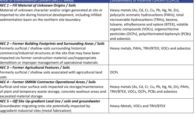
Based on the site history review, review of previous investigations and JBS&G’s understanding of site conditions, AECs and associated COPC have been identified and are presented in Table 5.1 and shown on Figure 3 (where appropriate).
Table 5.1: Areas of Environmental Concern and Associated Contaminants of Potential Concern
Areas of Environmental Concern (AEC) / Media Contaminants of Potential Concern (COPCs) AEC 1 – Fill Material of Unknown Origins / Soils
Material of unknown character and/or origin generated at site or imported to site during historical development, including infilled sedimentation basin on the northern site boundary
Heavy metals (As, Cd, Cr, Cu, Pb, Hg, Ni, Zn), polycyclic aromatic hydrocarbons (PAHs), total recroverable hydrocarbons (TRHs), bezene, toluene, ethylbenzene and xylene (BTEX), volatile organic compounds (VOCs), organochlorine pesticides (OCPs), polychlorinated biphenyls (PCBs) and asbestos
AEC 2 – Former Building Footprints and Surrounding Areas / Soils Formerly surficial / shallow soils surrounding historical
commercia/industrial structures at the site that may have been impacted via former construction material use/inappropriate demolition or improper management of operational materials
Heavy metals, PAHs, TRH/BTEX, VOCs and asbestos
AEC 3 – Former Agricultural Features / Soils
Formerly surficial / shallow soils associated with agricultural land
uses OCPs
AEC 4 – Former SMNW Contractor Operational Areas / Soils Surficial and near surface soils impacted via storage/maintenance of plant and temporary waste storage, concrete washout areas and excavated material storage
Heavy metals (As, Cd, Cr, Cu, Pb, Hg, Ni, Zn), PAHs, TRH/BTEX, VOCs, OCPs, PCBs and asbestos AEC 5 – Off Site Up-gradient Land Use / soils and groundwater
Groundwater migrating onto site potentially impacted by
upgradient industrial sites (metal fabrication) Heavy Metals, VOCs and TRH/BTEX
Review of the site history and environmental setting has not identified the potential presence or historical use at the site of per- or poly-fluorinated alkyl substances (PFAS).
5.2 Potentially Contaminated Media Potentially contaminated media comprise:
• Fill materials;
• Underlying natural soils;
• Groundwater; and
• Soil vapour.
5.3 Potential for Migration
Contaminants generally migrate from site via a combination of windblown dusts, rainwater infiltration, groundwater migration and surface water runoff. The propensity for contaminants to migrate is dependent on:
• The nature of the contaminants (solid/liquid/gas and mobility characteristics);
• The extent of the contaminants (isolated or widespread);
• The location of the contaminants (surface soils or at depth); and
©JBS&G Australia Pty Ltd | 57518/138923 Rev 1 16
• The site topography, geology, hydrology and hydrogeology.
The potential contaminants identified as part of the site area history review and previous
investigation are generally in either a solid form and liquid form. There is the potential for volatile compound impacts to occur in a vapour form in soils underlying the concrete slab at site.
In areas of unsealed surfaces, windblown dust may present a contaminant migration pathway requiring further assessment. The potential for contamination migration via surface water
movement and infiltration of water and subsequent migration through the soil profile is considered generally to be low given the extent of low permeability soils in the site.
Natural soils at the site comprise relatively impermeable clays overlying residual shale.
Notwithstanding, migration of potentially impacted groundwater may occur over moderate to long time periods. On this basis, migration of contamination via groundwater movement requires further consideration, albeit with consideration to the potential sources of contamination within and
adjoining the site.
5.4 Potential Exposure Pathways
Based on the COPCs identified in various media, as discussed above, and proposed site development activities, the exposure pathways for the site during and following development works include:
• Inhalation of contaminated dust liberated from soils or impacted soil vapour; and/or
• Potential dermal and oral contact to impacted soils and groundwater as present at shallow depths and/or accessible by future service excavations across the extent of the site; and/or
• Potential direct and/or indirect contaminant uptake by ecological receptors.
5.5 Receptors
Based on review of the preliminary development layout and the proposed land uses, the following human populations have been considered with regard to potential exposure to impacted site media :
• Current commercial workers as will be required to visit the site prior to and during redevelopment (including construction workers, consultants, planners, etc.);
• Future occupants of short-stay accommodation;
• Future potentially sensitive populations (e.g. child care centres);
• Future commercial workers as may occupy future buildings, basements and retail premises;
• Future users of open space areas (e.g. community parks, gardens, etc.) associated with the development; and
• Future sub-surface commercial workers, construction workers and maintenance personnel.
Ecological receptors at the site are limited to species established within infrequently visited landscaped garden areas. Off-site ecological receptors may potentially be impacted by surface water, groundwater and windblown dusts migrating from the site. Surrounding public open spaces and water bodies (the freshwater ecosystem of Strangers Creek) are also ecological receptors.
5.6 Preferential Pathways
For the purpose of this assessment, preferential pathways have been identified as natural and/or man-made pathways that result in the preferential migration of COPC as either liquids or gases.
Man-made preferential pathways are present throughout the site, generally associated with fill materials, and at near surface depths over the entire site. Fill materials are anticipated to have a high permeability than the underlying clayey soils.
©JBS&G Australia Pty Ltd | 57518/138923 Rev 1 17 Sub-surface services will be present as part of site redevelopment, throughout the site. Preferential pathways can be created by the generally higher permeability backfill used to re-instate trenches.
Preferential pathways are also important in the assessment of potential off-site sources of COPC.
Preferential pathways are potentially present in the adjoining road network, as associated with service easements.
©JBS&G Australia Pty Ltd | 57518/138923 Rev 1 18
6. Sampling Analysis and Quality Plan
6.1 Data Quality Objectives
Data quality objectives (DQOs) are statements that define the confidence required in conclusions drawn for data produced for a project, and which must be set to realistically define and measure the quality of data needed.
DQOs have been developed for this DSI, as discussed in the following sections.
6.1.1 State the Problem
The site is proposed to be redeveloped to accommodate a commercial development with potentially sensitive land uses (i.e. child care centres) and a two level basement.
In accordance with the requirements of the State Environmental Planning Policy No. 55 (SEPP55), characterisation of the potential contamination conditions is required to assess whether the site is considered suitable or can be made suitable for permissible site uses.
6.1.2 Identify the Decision
The decisions below generally follow the EPA (201712) decision making process for assessing urban redevelopment sites:
• Are there any unacceptable risks to likely onsite receptors from site media?
• Are there any issues relating to the local area background soil concentrations that exceed appropriate criteria?
• Are there any impacts of chemical mixtures?
• Are there any unacceptable aesthetic issues?
• Is there any evidence of or potential for migration of contaminants to the site?
• Is a site contamination strategy required?
6.1.3 Identify Inputs to the Decision Inputs to the decisions are:
• Site history and environmental setting information;
• Environmental data collected by sampling and analysis and site observations made during the current investigation;
• Assessment criteria based on the intended land uses, preliminary development details and project objectives, as documented in Section 7; and
• Confirmation that data generated by sampling and analysis are of an acceptable quality to allow reliable comparison to assessment criteria as undertaken by assessment of quality assurance/quality control (QA/QC) as per the data quality indicators (DQIs) established in Section 6.1.6.
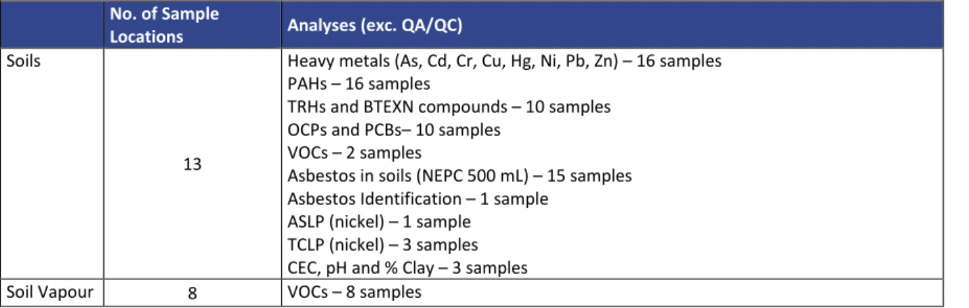
Specifically, sufficient data needs to be collected from each of the identified potentially impacted media (e.g. fill material and natural soils) at the site relating to the identified AECs and associated COPC.
12 Guidelines for the NSW Site Auditor Scheme (3rd Edition). NSW Environment Protection Authority, October 2017, EPA 2017;
©JBS&G Australia Pty Ltd | 57518/138923 Rev 1 19 6.1.4 Define the Study Boundaries
The study boundary comprises the extent of the site as shown on Figure 2 and Figure 3 and detailed in Sections 2.1 and 2.2.
The vertical extent of the study comprised the maximum depth of the deepest borehole (9.0 m bgl).
Six boreholes were extended through fill material and natural soils to the top of residual bedrock.
This DSI is limited in temporal extent to the period of site sampling (26 to 30 September 2019) and subsequent site inspection (23 June 2021). Due to the project objectives, seasonality was not assessed as part of this investigation.
6.1.5 Develop a Decision Rule
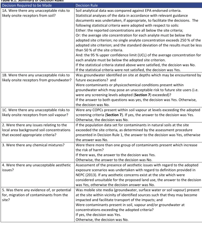
Laboratory analytical data was assessed against EPA endorsed criteria as identified in Section 7. The decision rules adopted to answer the decisions identified in Section 6.1.2 are summarised in Table 6.1.
Table 6.1: Summary of Decision Rules
Decision Required to be Made Decision Rule 1A. Were there any unacceptable risks to
likely onsite receptors from soil? Soil analytical data was compared against EPA endorsed criteria.
Statistical analyses of the data in accordance with relevant guidance documents was undertaken, if appropriate, to facilitate the decisions. The following statistical criteria were adopted with respect to soils:
Either: the reported concentrations are all below the site criteria;
Or: the average site concentration for each analyte must be below the adopted site criterion; no single analyte concentration exceeds 250 % of the adopted site criterion; and the standard deviation of the results must be less than 50 % of the site criteria.
And: the 95 % upper confidence limit (UCL) of the average concentration for each analyte must be below the adopted site criterion.
If the statistical criteria stated above were satisfied, the decision was No.
If the statistical criteria were not satisfied, the decision was Yes.
1B. Were there any unacceptable risks to
likely onsite receptors from groundwater? Was groundwater identified on site at depths which may be encountered by future excavations? and
Were contaminants or physicochemical conditions present within groundwater which may pose an unacceptable risk to future site users (i.e.
were any screening levels adopted (Section 7) exceeded)?
If the answer to both questions was yes, the decision was Yes. Otherwise, the decision was No.
1C. Were there any unacceptable risks to
likely onsite receptors from soil vapour? Were any COPCs present within soil vapour at levels exceeding the adopted screening criteria (Section 7). If yes, the answer to the decision was Yes.
Otherwise, the decision was No.
2. Were there any issues relating to the local area background soil concentrations that exceed appropriate criteria?
If the population data set for contaminants in natural soils at the site exceeded the site criteria, as determined by the assessment procedure presented in Decision Rule 1, the answer to the decision was Yes, otherwise the answer was No.
3. Were there any chemical mixtures? Were there more than one group of contaminants present which increase the risk of harm?
If there was, the answer to the decision was Yes.
Otherwise, the answer to the decision was No.
4. Were there any unacceptable aesthetic
issues? Assessment of the presence of aesthetic issues with regard to the adopted exposure scenarios was undertaken with regard to definition provided in NEPC (2013). If any aesthetic concerns exist at the site which were
considered unsuitable for the proposed land use, the answer to the decision was Yes, otherwise the decision answer was No.
5. Was there any evidence of, or potential for, migration of contaminants from the site?
Was mobile site media (groundwater, surface water or soil vapour) present at the site within vicinity of identified sources such that they may become impacted and facilitate transport of the impacts; and
Were contaminants present in soil, vapour and/or groundwater at concentrations exceeding the adopted criteria?
If yes, the decision was Yes.
Otherwise, the decision was No.
©JBS&G Australia Pty Ltd | 57518/138923 Rev 1 20
Decision Required to be Made Decision Rule 6. Is a Site Management Strategy
Required? Is the answer to any of the above decisions Yes?
If Yes, a site management strategy may be required to address unacceptable contamination concerns at the site so as to make the site suitable for the proposed land uses.
If No, a site management strategy is not required and the site is considered suitable, from a contamination view point, for the proposed land uses.
6.1.6 Specify Limits of Decision Error
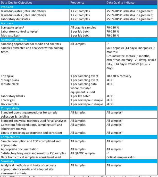
This step is to establish the decision maker’s tolerable limits on decision errors, which are used to establish performance goals for limiting uncertainty in the data. Data generated during this project must be appropriate to allow decisions to be made with confidence.
Specific limits for this project have been adopted in accordance with the appropriate guidance from the NSW EPA, NEPC (2013), ANZG (201813), EPA (202014), appropriate indicators of data quality (DQIs used to assess QA/QC) and standard JBS&G procedures for field sampling and handling.
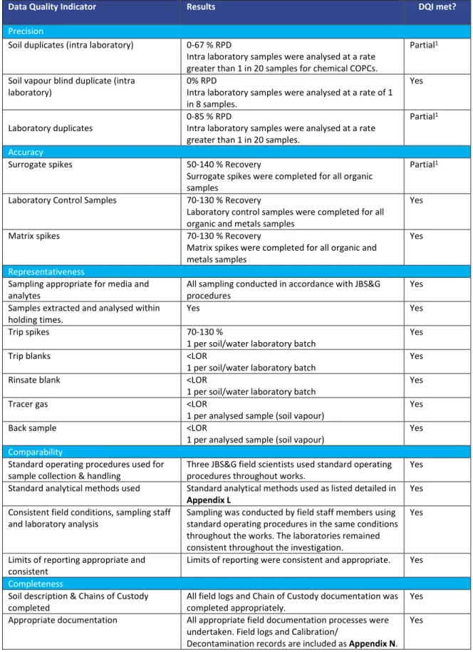
To assess the usability of the data prior to making decisions, the data will be assessed against pre- determined DQIs for completeness, comparability, representativeness, precision and accuracy.
The pre-determined DQIs established for the project are discussed below in relation to precision, accuracy, representativeness, comparability, completeness and sensitivity (PARCCS parameters), and are shown in Table 6.2.
• Precision - measures the reproducibility of measurements under a given set of conditions.
The precision of the laboratory data and sampling techniques is assessed by calculating the Relative Percent Difference (RPD) of duplicate samples.
• Accuracy - measures the bias in a measurement system. The accuracy of the laboratory data that are generated during this study is a measure of the closeness of the analytical results obtained by a method to the ‘true’ value. Accuracy is assessed by reference to the analytical results of laboratory control samples, laboratory spikes and analyses against reference standards.
• Representativeness –expresses the degree which sample data accurately and precisely represent a characteristic of a population or an environmental condition.
Representativeness is achieved by collecting samples on a representative basis across the site, and by using an adequate number of sample locations to characterise the site to the required accuracy.
• Comparability - expresses the confidence with which one data set can be compared with another. This is achieved through maintaining a level of consistency in techniques used to collect samples; ensuring analysing laboratories use consistent analysis techniques and reporting methods.
• Completeness – is defined as the percentage of measurements made which are judged to be valid measurements. The completeness goal is set at there being sufficient valid data generated during the study.
• Sensitivity – expresses the appropriateness of the chosen laboratory methods, including the limits of reporting, in producing reliable data in relation to the adopted criteria.
If any of the DQIs are not met, further assessment of the data set is required in order to determine whether the non-conformance has significant effects on the usefulness of the data. Corrective action
13 Australian and New Zealand Guidelines for Fresh and Marine Water Quality. Australian and New Zealand and Australian State and Territory Governments (ANZG, 2018)
14 Contaminated Land Guidelines: Consultants reporting on contaminated land. NSW EPA, May 2020 (EPA 2020)