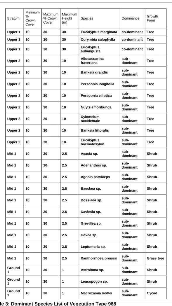
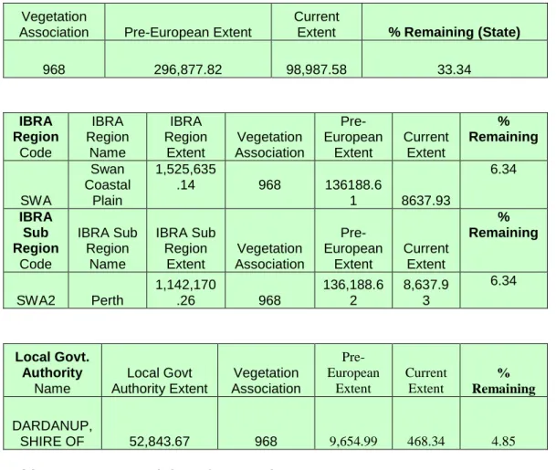
SUMMARY
BACKGROUND & SCOPE
ASSESSMENT METHODOLOGY
The decision to submit a project to the state Environmental Protection Agency (EPA) is based on whether it is a significant environmental impact, TPS change, or project of large scale and/or public interest. The decision to submit a project to the Commonwealth Department of Environment, Water, Heritage and the Arts (DEWHA) is based on whether the project would have a significant impact on matters of national environmental importance, e.g.
ASSESSMENT OF ASPECTS AND IMPACTS
Provided that the works do not interfere with intact areas of vegetation beyond the project area, there will be minimal impacts to this area. The TEC/ESA area on the south side of the highway between SLK 142.77 and 144.51 also includes an Aboriginal area which will not be affected. Consultations with the Department of Water have confirmed that the proposed works will not disturb or disrupt any natural drainage and surface runoff patterns.
The culvert for a small transient discharge (SLK 145.7) will be replaced and extended, but as the works will be carried out during the dry summer months there is unlikely to be any impact on the watercourse. Visual experience The proposed works will result in minor visual effects in the short term during construction. Provided that traffic management and signposting comply with the standards of the main roads, the proposed works do not pose a significant threat to public safety.
Contamination The works are within the road reserve and there are no known previous land use activities on or adjacent to the project area that may have caused contamination, e.g. as the proposed works are wholly within the existing road reserve, no further changes are required to the planning scheme of the local government or the regional scheme.
DECISION TO REFER
The case of dieback was identified (GHD) in vegetation classified as Very Good on the southern side of the highway between SLK 143.87 and 144.65 and advised to consult with DEC before any activity in the area. This advice is not available at this stage; however, the area will be clearly demarcated to prevent access as a management strategy. As it is being proclaimed in terms of the Water and Irrigation Rights Act, a Permit to disturb beds and banks will be required from the Department of Water before construction begins.
Groundwater Drainage or drainage changes are not required, so there are no changes to groundwater levels or quality. The construction work is not expected to contribute significantly to the noise levels at these receivers if the work is limited to normal working hours. No further investigations are required as no drainage or excavation below the water table is planned.
ENVIRONMENTAL MANAGEMENT PLAN
Works associated with the construction of the development should not prevent public access along the adjacent reserve. Ensure that the construction of the proposal is managed to a standard that minimizes any adverse impact on the environment. Ensure that the site is managed to ensure that the construction of the proposal will have minimal impact on the surrounding environment.
All waste material from the development must be completely removed from the site on completion of the development. Final cleaning will be to the satisfaction of the Project Manager and the Site Superintendent. I checked the DEC nature map system (http://naturemap.dec.wa.gov.au./default.aspx) and there is no listing of this species (Anthotium junciforme) at any of the registered sites.
The location information for the record is not accurate, although it does plot on the north side of the highway, so my previous advice that it can happen. Provide more details on species and location of the P4 flora that may be on the north side. So for TEC values, DEC, through the local South West Regional Office, has no objection to the proposed works on this side of the carriageway.
I also advise that a quick check of the desktop data reveals the likelihood of Priority 4 flora occurring on the north side of the highway. From the aerial you sent me, it looks like the northern part of the road is mostly cleared. We have been advised by the regional DEC that the species Anthotium junciforme may be present on the north side of the highway in Waterloo through data from FloraBase.
On 1 September 2010, Dr Eleanor Bennett undertook a survey for declared rare and priority flora along the northern side of the South Western Expressway between Waterloo Road and Hynes Road. A search was undertaken for the above taxa through a transect over the full length of the road edge. Three of the four characteristics of the Eucalyptus rudis trees along the investigated area correspond to the characteristics for the P4 taxon, Eucalyptus rudis subsp.
The Uninterpretable category covers the entire western side of the highway study area buffer, most of its eastern side, and the TECs (where recent fire damage has limited their interpretation). Limit the movement of machines and other vehicles to the boundaries of the areas to be cleared. I note that MRWA commissioned a report from GHD (South Western Highway Reconstruction and Passing Lanes between Burekup and Picton: OIA and EMP July 2009) which contained an assessment of the disease management.
We are planning to improve this part of the highway with (overlay) and some widening.

EGETATION C LEARING A SSESSMENT R EPORT
There are two Endangered Ecological Communities (TECs) on the opposite side of the highway where no clearing is proposed, which are also surrounded by rural areas. GHD EIA 2008: Threatened fauna and habitat assessment and survey (opportunistic) Site assessment of flora/vegetation. b) Native vegetation should not be cleared if it comprises all or part of, or is necessary for the maintenance of, significant habitat for fauna native to Western Australia. GHD EIA 2008: Threatened fauna and habitat assessment and survey (opportunistic) Site assessment of flora/vegetation. c) Native vegetation should not be cleared if it includes or is necessary for the continued existence of rare flora.
Most of these occur on the south side of the Waterloo Nature Reserve, which will not be affected by the project. There are none in the proposed work area, but 2 TECs included in the ESA have been identified on the south side of the highway between SLK 142.77 and 144.51. Areas outside the project area will not be affected by the proposed works.
GHD EIA 2008: Survey of threatened flora. e) Native vegetation should not be cleared if it is significant as a remnant of native vegetation in an area that has been extensively cleared. GHD EIA 2008: Survey of threatened flora. f) Native vegetation should not be cleared if it grows in, or in relation to, an environment connected to a watercourse or wetland. However, canal replacement and extension will require a permit to disturb the beds and banks before construction begins.
Department of Water Consultancy Examination of aerial photography Desktop and site assessments. g) Native vegetation should not be cleared if the clearing of the vegetation is likely to cause significant soil degradation. Native vegetation should not be cleared if the clearing of the vegetation is likely to have an impact on the environmental values of any adjacent or nearby conservation area. The clearing of vegetation outside the ESA is not considered to be contrary to this clearing principle.
Taking measures within the EMP to prevent and control this risk is considered adequate for this project. j) Native vegetation shall not be cleared if the clearing of vegetation is likely to cause or exacerbate the occurrence or intensity of flooding. A registered Aboriginal Heritage Site (ID 17775) is located on the south side of the highway and extends between Wireless Road and Waterloo Road. The proposed clearing is deemed not to conflict with any of the Clearing Principles.
Figure 6: View to the northeast showing the vicinity of the closet dwelling at 144.10 SLK - clearing on the left. Figure 10: View to the northeast showing the narrowness of the road reserve at 143.4 SLK - clearing on the left.
