Printed copies are uncontrolled unless marked otherwise
PRELIMINARY ENVIRONMENTAL IMPACT ASSESSMENT AND ENVIRONMENTAL MANAGEMENT PLAN
DUCK CREEK FLOOD DAMAGE REINSTATEMENT AND REHABILITATION WORKS
2006
MAIN ROADS Western Australia PEIA & EMP FOR DUCK CREEK
1 of 52
CONTENTS
1. INTRODUCTION ... 3
2. BACKGROUND ... 3
3. DESCRIPTION OF THE PROJECT ... 4
METHODOLOGY ... 6
3.1.1 Preliminary Desktop Study ... 7
3.1.2 Site Investigation ... 8
4. EXISTING ENVIRONMENT ... 8
5. CLEARING OF NATIVE VEGETATION ... 9
6. DECISION TO REFER ... 11
7. ENVIRONMENTAL MANAGEMENT PLAN ... 12
8. REFERENCES ... 17
APPENDIX A LOW IMPACT ENVIRONMENTAL SCREENING CHECKLIST ... 18
APPENDIX B SITE PHOTOGRAPHS... 20
APPENDIX C DEPARTMENT OF CONSERVATION AND LAND MANAGEMENT’S THREATENED FLORA AND FAUNA DATABASE SEARCHES ... 28
APPENDIX D AUSTRALIAN HERITAGE PLACES INVENTORY, HERITAGE COUNCIL OF WESTERN AUSTRALIA AND THE MUNICIPAL HERITAGE INVENTORY DATABASE SEARCHES ... 33
APPENDIX E DEPARTMENT OF INDIGENOUS AFFAIRS DATABASE SEARCH ... 35
APPENDIX F DOE’S SENSITIVE WATER RESOURCES DATABASE SEARCH ... 38
APPENDIX G WAPC’S ACID SULFATE SOILS MAPPING ... 41
APPENDIX H DEPARTMENT OF AGRICULTURE ADVICE ON DECLARED WEEDS 44 APPENDIX I DEPARTMENT OF ENVIRONMENT AND HERITAGE DATABASE SEARCH ... 46
DUCK CREEK
COMBINED ENVIRONMENTAL REPORT
1. INTRODUCTION
Earlier this year, within a period of four months (Jan to April 2006) the Duck Creek Bridge abutment and approach road was washed-out to a length of 40m by cyclones Emma, Clare and Glenda.
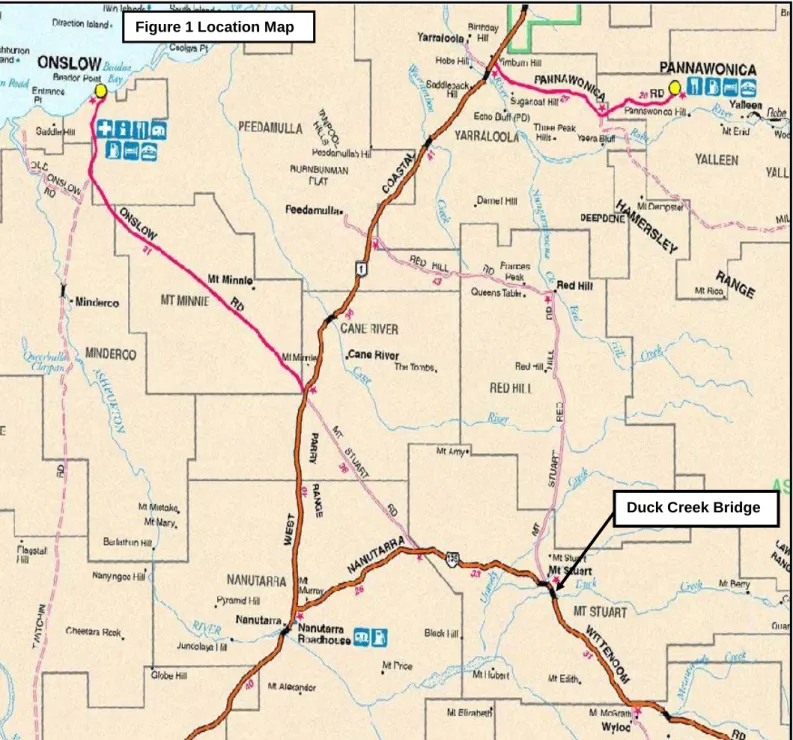
This structure is located in the southern-west part of Pilbara Region (managed by the Gascoyne region) on the Nanutarra – Munjina Road (SLK 62.29) within the Shire of Ashburton.
As a temporary solution, the washed-out section of the road (western abutment) was repaired with loosely compacted and poorly graded fill material and rock rubble batter which was easily accessible material available at the time.
Main Roads Gascoyne undertook the necessary clearing for fill material under the exemption stated in the Environmental Protection (Clearing of Native Vegetation) Regulations 2004, Section 5 Item 21 which states “Clearing that is the result of the construction of a temporary vehicular track that is necessary to bypass a stretch of road that is impassable due to unforseen damage to part of that stretch of road.”
The emergency repair works was crucial for reopening access to the highway which services the mining industry in the area.
2. BACKGROUND
This bridge has been subjected to many floods before; and the type of damage is a repetition of previous similar incidents.
Studies have been carried out and many cost effective options have been considered to find a road user safe solution.
Improvements to the surrounding floodways and bridge opening will lower the water- depths and water-velocities on the bridge; eventually creating a safe environment for the bridge abutments and reduce silt transportations.
The material generated from excavating-and-lowering the floodway could be utilised on the side-track construction; possibly a considerable saving.
Since there is a shortage of quality material for the works, fill material and rock will be brought in from three new gravel pits.
As per Main Roads’ Environmental Assessment and Approval process, the Low Impact Environmental Screening Checklist has been completed for the proposal, refer Appendix A. As the proposed works involves the clearing of native vegetation and the creation of new rock and gravel pits, the preparation of a project specific Preliminary Environmental Impact Assessment (PEIA) and Environmental Management Plan (EMP) is required. This report fulfils this requirement.
MAIN ROADS Western Australia PEIA & EMP FOR DUCK CREEK 3 of 52
3. DESCRIPTION OF THE PROJECT
The proposed reinstatement and rehabilitation works to the Duck Creek Bridge involves the following:
• Reinstatement of the western abutment.
• Rehabilitation of the bridge which includes:
o Lowering the eastern floodway based on recommendation from waterways studies
o Additional protections on the western abutment by implement a guide-bank on right-bank. Eventually this will protect the bridge substructure and at the same time protect creek erosion.
o Replacing the visibly settled eastern approach slab as part of rehabilitation works to provide an even road surface.
The approximate length of the damage is estimated to be 25 meters from the bridge. This was extended up-to 40m at the time of temporary re-instatement works to bring in fill material. The depth is almost the full height from the ground-level to the road surface level, ie approximately 8m.
The total volume of earth required for the Duck Creek Bridge repair works will be approximately 17,000m3.
The location and boundaries of the study area are shown in Figures 1 and 2 and include the following features:
• Three material pits near the Duck Creek bridge washout. These sites can best be described as iron capped hills with rocky loose shale.
• Side-track access to the east of the bridge. This track is the old highway which was decommissioned in 1985. The same alignment will be used for this project.
Figure 1 Location Map
Duck Creek Bridge
MAIN ROADS Western Australia PEIA & EMP FOR DUCK CREEK
5 of 52
C 10 Duck Creek Bridge
Old Road Alignment Figure 2 Duck Creek Project Area
Rock Quarry
Nanutarra-Munjina Road
A
B Rock Quarry
Rock Quarry
Old Road Alignment
Fence Line 9
11 12 13
Photograph Locations 9-13
Methodology
3.1.1 Preliminary Desktop Study
A preliminary assessment of the project area and its potential constraints was undertaken by reviewing a number of government agency managed databases.
Wetlands
The locations of wetlands within the project area was determined using the Commonwealth Department of Environmental and Heritage (DEH) mapping tool, Department of Environment (DoE) Environmentally Sensitive Area (ESA) mapping tool (http://portal.environment.wa.gov.au/portal/page?_pageid=53,2569721&_dad=portal&_sc hema=PORTAL.
Threatened Flora, Fauna and Communities, Conservation Reserves and ESAs Department of Conservation and Land Management’s (CALM’s) database (contact CALM direct) was searched for known populations of threatened flora, fauna and Threatened Ecological Communities (TECs) and conservation reserves, refer Appendix C. A quick TEC check can be done using the ESAs mapping tool
http://portal.environment.wa.gov.au/portal/page?_pageid=53,2569721&_dad=portal&_sch ema=PORTAL.
Air Quality
The need for a local air quality assessment was determined using the criteria outlined in the MRWA environmental guideline, Air Quality.
Heritage
Non-indigenous heritage was examined utilising the Australian Heritage Places Inventory (http://www.heritage.gov.au), Heritage Council of Western Australia
(http://register.heritage.wa.gov.au/) and the Shire of Ashburton’s Municipal Heritage Inventory refer Appendix D.
Aboriginal Heritage
A Search of the Department of Indigenous Affairs’ (DIA’s)
(http://www.dia.wa.gov.au/Heritage/SitesSurveysSearch.aspx) database was undertaken to determine whether the project area contains any sites of Aboriginal heritage, refer Appendix E.
Sensitive Water Resources
The Water Information Officer of the Department of Water’s regional office was consulted on sensitive water resources (including Public Drinking Water Source Areas) to determine whether the project area supported, or was adjacent to, any significant lakes, rivers or wetlands or proclaimed areas, refer Appendix F. To contact a water Information Officer http://portal.environment.wa.gov.au/pls/portal/PORTAL.wwa_app_module.show?p_sessio nid=4837&p_header=true
Contaminated Sites
The project area is within a reserve that has remained in control of Main Roads and there is no evidence of contamination therefore it is not considered a contaminated site.
Acid Sulfate Soils
The Western Australian Planning Commission’s acid sulfate soils maps were reviewed and the self assessment done (http://www.wapc.wa.gov.au/Publications/213.aspx) to determine what level of risk the project area is exposed to, refer Appendix H.
MAIN ROADS Western Australia PEIA & EMP FOR DUCK CREEK 7 of 52
Weeds
Consultation was undertaken with the Department of Agriculture to determine whether there are any known populations of declared plants or significant weeds in or adjacent to the project area, refer Appendix H.
Dieback
Project receives <400 mm of rain so determined not to be an issue.
Commonwealth Referral
The decision to refer the project to the Commonwealths DEH was based upon whether the project was going to impact upon matter of national significance, eg World Heritage properties, protected wetlands and migratory species, Commonwealth marine areas, threatened species or communities or nuclear actions (refer to the Commonwealth webpage www.deh.gov.au/epbc/assessmentsapprovals/index.html for further information and the search tool page at http://www.deh.gov.au/erin/ert/epbc/imap/map.html), refer Appendix I.
3.1.2 Site Investigation
A site visit was carried out by Srinath Fernando on 20/04/06 to examine the general features of the area. The broad vegetation types in the vicinity of the project area were identified. Other issues that were considered included topography, the impacts on creek lines, property access and the potential for noise and vibration impacts (dilapidation).
4. EXISTING ENVIRONMENT
Beard (1975) described the physiographic unit surrounding the Duck Creek area as “All of this unit consists of very poor stony country-the northern portion being especially so-and is mapped as sparse shrub steppe.”
The general cover that was found over the three rock quarry sites (as seen in Appendix B, photographs 3 to 8) consisted of Triodia basedowii and Triodia wiseana with sparsely spaced shrubs such as Acacia bivenosa, Cassia pruiinosa and Cassia oligophylla..
Sparse populations of Acacia xiphophylla were also observed.
Vegetation along the old highway track to the east of the bridge is lined with Eucalyptus camaldulensis within the river bed and Acacia citrinoviridis.
The vegetation in all project areas is well represented and not classified as threatened or endangered.
5. CLEARING OF NATIVE VEGETATION
Under the amended Environmental Protection Act 1986 (EP Act) clearing of native vegetation must be under the authority of a clearing permit.
In assessing whether the project is likely to have a significant impact on the environment, the project has been assessed against the DoE’s 10 principles of clearing, see table below.
Clearing Principles - Environmental Protection Act Section 5 Yes/No Does the area to be cleared comprise a high level of biological diversity? No Does the area to be cleared comprise the whole or a part of, or is necessary
for the maintenance of, a significant habitat for fauna indigenous to Western Australia?
No
Does the area to be cleared include, or is necessary for the continued existence of, rare flora?
No Does the area to be cleared comprise the whole or a part of, or is necessary
for the maintenance of, a threatened ecological community?
No Is the area to be cleared significant as a remnant of native vegetation in an
area that has been extensively cleared?
No Does the area to be cleared within, or in association with, an environment
associated with a watercourse or wetland?
No Is the clearing of the vegetation likely to cause appreciable land degradation? No Is the clearing of the vegetation likely to have an impact on the environmental
values of any adjacent or nearby conservation area?
No Is the clearing of the vegetation likely to cause deterioration in the quality of
surface or underground water?
No Is the clearing of the vegetation likely to cause, or exacerbate, the incidence
or intensity of flooding?
No
Rock and gravel material will be sourced from 3 different locations (Figure 2).
Rock Quarry A is located on the right hand side of Nanutarra-Munjina Road at 60.65 SLK.
The site was pegged and marked with the dimensions being 80 meters wide and 120 meters long, making total clearing area 9.6 hectares.
Rock Quarry B is located on the right hand side of Nanutarra-Munjina Road at 61.03 SLK.
The site was pegged and marked with the dimensions being 30 meters wide and 129 meters long, making the total clearing area 3.87 hectares.
Rock Quarry C is located on the left hand side of Nanutarra-Munjina Road at 62.20 SLK.
The site was pegged and marked with the dimensions being 87.5 meters wide and 165 meters long, making the total clearing area 14.43 hectares.
Total clearing area for materials is 27.9 hectares. Please note that this total represents an area that has been pegged out in the field at the time of the emergency works and that the actual clearing requirements would be expected to be significantly smaller.
No clearing of remnant native vegetation will take place for the side access track since the old highway alignment will be utilised. (See Appendix B)
There is some regrowth of Acacia pyrifolia DC at the southern end of the old highway (See Appendix B Photograph 13). This regrowth is approximately 20 years old.
MAIN ROADS Western Australia PEIA & EMP FOR DUCK CREEK 9 of 52
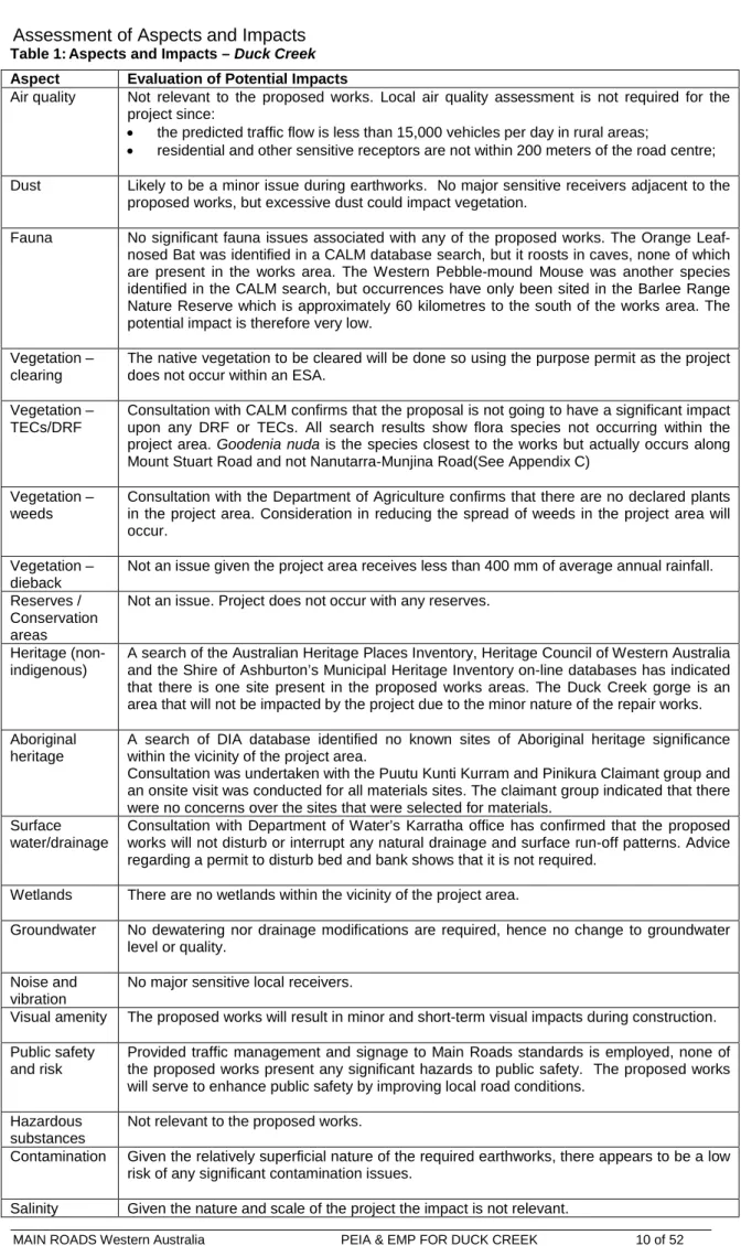
Assessment of Aspects and Impacts
Table 1: Aspects and Impacts – Duck Creek Aspect Evaluation of Potential Impacts
Air quality Not relevant to the proposed works. Local air quality assessment is not required for the project since:
• the predicted traffic flow is less than 15,000 vehicles per day in rural areas;
• residential and other sensitive receptors are not within 200 meters of the road centre;
Dust Likely to be a minor issue during earthworks. No major sensitive receivers adjacent to the proposed works, but excessive dust could impact vegetation.
Fauna No significant fauna issues associated with any of the proposed works. The Orange Leaf- nosed Bat was identified in a CALM database search, but it roosts in caves, none of which are present in the works area. The Western Pebble-mound Mouse was another species identified in the CALM search, but occurrences have only been sited in the Barlee Range Nature Reserve which is approximately 60 kilometres to the south of the works area. The potential impact is therefore very low.
Vegetation – clearing
The native vegetation to be cleared will be done so using the purpose permit as the project does not occur within an ESA.
Vegetation – TECs/DRF
Consultation with CALM confirms that the proposal is not going to have a significant impact upon any DRF or TECs. All search results show flora species not occurring within the project area. Goodenia nuda is the species closest to the works but actually occurs along Mount Stuart Road and not Nanutarra-Munjina Road(See Appendix C)
Vegetation – weeds
Consultation with the Department of Agriculture confirms that there are no declared plants in the project area. Consideration in reducing the spread of weeds in the project area will occur.
Vegetation – dieback
Not an issue given the project area receives less than 400 mm of average annual rainfall.
Reserves / Conservation areas
Not an issue. Project does not occur with any reserves.
Heritage (non- indigenous)
A search of the Australian Heritage Places Inventory, Heritage Council of Western Australia and the Shire of Ashburton’s Municipal Heritage Inventory on-line databases has indicated that there is one site present in the proposed works areas. The Duck Creek gorge is an area that will not be impacted by the project due to the minor nature of the repair works.
Aboriginal heritage
A search of DIA database identified no known sites of Aboriginal heritage significance within the vicinity of the project area.
Consultation was undertaken with the Puutu Kunti Kurram and Pinikura Claimant group and an onsite visit was conducted for all materials sites. The claimant group indicated that there were no concerns over the sites that were selected for materials.
Surface water/drainage
Consultation with Department of Water’s Karratha office has confirmed that the proposed works will not disturb or interrupt any natural drainage and surface run-off patterns. Advice regarding a permit to disturb bed and bank shows that it is not required.
Wetlands There are no wetlands within the vicinity of the project area.
Groundwater No dewatering nor drainage modifications are required, hence no change to groundwater level or quality.
Noise and vibration
No major sensitive local receivers.
Visual amenity The proposed works will result in minor and short-term visual impacts during construction.
Public safety and risk
Provided traffic management and signage to Main Roads standards is employed, none of the proposed works present any significant hazards to public safety. The proposed works will serve to enhance public safety by improving local road conditions.
Hazardous substances
Not relevant to the proposed works.
Contamination Given the relatively superficial nature of the required earthworks, there appears to be a low risk of any significant contamination issues.
Salinity Given the nature and scale of the project the impact is not relevant.
Table 1: Aspects and Impacts – Duck Creek Aspect Evaluation of Potential Impacts
Acid Sulfate Soils
The WAPC’s self-assessment (Planning Bulletin 64) indicates that no further soil investigation is required for the project.
Statutory Land Use Planning
Not relevant to the proposed works
6. DECISION TO REFER
Given the scale of the project, the low significance of its impacts to the surrounding environment and the environmental management measures proposed, the project does not require referral to the WA Environmental Protection Authority or the Commonwealth Department of the Environment and Heritage.
MAIN ROADS Western Australia PEIA & EMP FOR DUCK CREEK 11 of 52
7. ENVIRONMENTAL MANAGEMENT PLAN
This section of the report (the EMP) has been developed for the project area following the completion of the above sections. The main aims of this EMP is to provide a
management plan to assist in minimising the environmental impacts of the activities associated with the proposed works and identify who is responsible for the implementation of the management strategies.
This EMP will only address the actions already listed as well as any site-specific issues that were identified during the PEIA. The project specific management measures
identified within this EMP are in addition to the standard specifications used for Category 2 projects. The environmental management measures/conditions in Main Road’s
Specifications 203, 204, 301, 302 and 304 are still to be followed where applicable.
The areas that require special management will be addressed in terms of:
• area of management (eg vegetation);
• the timing of the various management requirements;
• the management objectives for each area;
• the management strategies that are necessary to minimise the impact;
• the person/s responsible for implementing the management action; and
• on whose advise or Main Roads requirement
ENVIRONMENTAL MANAGEMENT PLAN Area of
management
Timing Management objective Management Strategy Responsibility Whose
advice Communication All phases of
Construction
The Project Manger is required to identify both internal and external stakeholders, obtain their requirements on the Project and communicate as required or at regular intervals with key stakeholders.
Develop and implement a communication plan including response to complaints, liaising/reporting to government agencies, engagement with the community and other when work is performed outside the normal hours with specific reference to nuisance issues such as noise, dust and lightning spill.
Project Manager Main Roads
Vegetation Clearing - Record-keeping
All phases of Construction
All projects should maintain the required records relating to clearing native vegetation under the purpose permit
Clearing:
• a copy of the PEIA & EMP (Minor projects) for small projects;
• a map showing the location where the clearing occurred, recorded in an ESRI Shapefile;
• the size of the area cleared (in hectares);
• the dates on which the clearing was done.
Project Manager DoE
Revegetation and rehabilitation of areas:
• a copy of each Revegetation Plan;
• a map showing the location of any area revegetated and rehabilitated recorded in an ESRI Shapefile;
• a description of the revegetation and rehabilitation activities undertaken; and
• the size of the area revegetated and rehabilitated (in hectares).
Project Manager DoE
Each offset implemented:
• a copy of each offset proposal;
• a map showing the location of any offset implemented recorded in an ESRI Shapefile;
• a description of the offset implemented; and
• the size of the area of the offset (in hectares).
Project Manager DoE
Vegetation Clearing - Record-keeping
All phases of Construction
All projects should maintain the required records relating to clearing native vegetation
Each management strategy implemented:
• a map showing the location of any area to which a management strategy has been
Project Manager DoE
MAIN ROADS Western Australia PEIA & EMP FOR DUCK CREEK 13 of 52
ENVIRONMENTAL MANAGEMENT PLAN Area of
management
Timing Management objective Management Strategy Responsibility Whose
advice (cont.) under the purpose permit applied recorded in an ESRI Shapefile;
• a description of the management strategy implemented; and
• the size of the area to which the management strategy was applied (in hectares).
Control of weeds, dieback and other pathogens:
• a copy of any management plan prepared; and
• for any pathogen other than dieback, the appropriate steps taken
Project Manager DoE
Vegetation - Clearing
Pre-
Construction
Ensure that the overall
objectives of the alignment and construction works are
compatible with maintaining and, where possible,
enhancing the biological integrity of the surrounding environment and minimising vegetation loss and
degradation; and
Ensure the retention of as many habitat trees, shrubs and vegetated corridors for fauna as possible, particularly where associated with riparian zones.
Selection of designs/locations that minimise adverse impacts on the biological environment
Project Manager Main Roads Construction works to be undertaken in summer to
reduce the potential for soil erosion and drainage line siltation due to vegetation removal and heavy rains.
Project Manager Main Roads
Any stockpiled vegetation from clearing works shall not be burnt. This vegetation shall be used during any rehabilitation works and either chipped or replaced according to the EMP.
Project Manager Main Roads
Stormwater drainage shall be treated and disposed of in accordance with DoE requirements
Project Manager DoE
Surface Drainage
Pre-
Construction
Maintain the hydrological regime that exists prior to the construction of the proposal
Ensure that the road blends in with the surrounding environment
Project Manager Main Roads
Visual Amenity Pre-
Construction
Ensure that the road blends in with the surrounding
environment
Access to private property and appropriate traffic management measures should be planned and implemented prior to the construction of works
Project Manager Main Roads
Noise, Vibration and Dust
Construction Ensure that the construction of the proposal does not become a nuisance to the public
Works associated with the construction of the development should not prevent public access along the adjacent reserve. Public access should be maintained along the reserve at all times
Project Manager Main Roads
ENVIRONMENTAL MANAGEMENT PLAN Area of
management
Timing Management objective Management Strategy Responsibility Whose
advice Any complaints regarding dust will be attended to
as soon as possible
Project Manager Main Roads Where it is found that trucks leaving the site are
carrying excessive material onto sealed surfaces, these areas will be swept to reduce dust
generation and maintain traffic safety.
Project Manager Main Roads
Watering, the use of hydromulch or other forms of mulching to protect loose surfaces shall be used as mitigation measures
Project Manager Main Roads
The designated servicing area will be bunded to contain any spills or leaks and shall not be located in an area adjacent to any drainage areas or watercourses or will drain into a temporary sump.
Project Manager Main Roads
Pollution and Litter
Construction Ensure that the construction of the proposal is managed to a standard that minimises any adverse impacts on the environment.
Emergency cleanup procedures shall be
implemented in the case of any spillage. These will include control of spilled material and removal of contaminated soil to an approved site.
The contractor shall ensure appropriate equipment is available at all times to control any spills and shall notify the Superintendent’s Representative as soon as possible following a spill.
Project Manager Main Roads
All waste oil will be collected for recycling and any empty fuel/oil containers, used filters and waste hydraulic parts to be collected and stored in an allocated area then removed to an approved site.
Project Manager Main Roads
Dumping or temporary storage of bitumen, asphalt, concrete or aggregate should only occur at
designated depots or controlled hardstands.
Project Manager Main Roads
The project areas, including hardstand areas, will be kept in a tidy manner at all times.
Project Manager Main Roads All litter on the project will be placed into lidded
bins and disposed of at an approved site.
Project Manager Main Roads No fires shall be lit within the project area Project Manager Main Roads Fire Construction Ensure that the fire risk Machinery will be fitted with approved spark Project Manager Main Roads
MAIN ROADS Western Australia PEIA & EMP FOR DUCK CREEK 15 of 52
ENVIRONMENTAL MANAGEMENT PLAN Area of
management
Timing Management objective Management Strategy Responsibility Whose
advice associated with the
construction of the proposal is minimised.
arresting mufflers.
A water tanker will be on site at all times. Contractor Main Roads If any materials of significance to Aboriginal people
are discovered, works will immediately cease within 100m of the material and the site will be examined by a qualified archaeologist.
Project Manager DIA
Aboriginal Heritage
Construction Ensure that there is no unauthorised disturbance to Aboriginal heritage sites during construction
The DIA will be notified in the event of any
significant Aboriginal Heritage discovery. Project Manager
Aboriginal Heritage (cont.)
Construction Ensure that there is no unauthorised disturbance to Aboriginal heritage sites during construction
If skeletal material is uncovered during works the WA Police Service will also be advised
immediately.
Project Manager
A formal induction program will be conducted for all personnel prior to commencing work on the site.
The program will aim to make them fully aware of all management strategies.
Project Manager Main Roads
Site
Management
Construction Ensure that the site is managed to ensure that
construction of the proposal will have minimal impact upon the surrounding environment
Site office and materials storage areas will be
located on previously disturbed/ designated area Project Manager Main Roads Replace the cleared trees with locally occurring
natives Project Manager Main Roads
Rehabilitation Post-
Construction
Leave the project area free from debris; and
Rehabilitate the project area so that the revegetated area provides a net increase in area of native vegetation at the site.
All waste materials from the development are to be completely removed from the site upon completion of the development. Final clean-up shall be to the satisfaction of the Project Manager and the Site Superintendent.
Project Manager Main Roads
8. REFERENCES
Beard, J.S. (1976) Vegetation survey of Western Australia: the vegetation of the Pilbara area Western:map and explanatory notes to sheet 5, 1:10,000,000 series Australia, map and explanatory memoir, 1:250,000 series
MAIN ROADS Western Australia PEIA & EMP FOR DUCK CREEK
17 of 52
Appendix A
Low Impact Environmental Screening Checklist
MAIN ROADS Western Australia PEIA & EMP FOR DUCK CREEK 19 of 52
Appendix B
Site Photographs
Photograph 1. Duck Creek Flood Damage - Nanutarra Munjina Rd - 62.29 SLK- South East View
Photograph 2. Duck Creek Flood Damage - Nanutarra Munjina Rd - 62.29 SLK- North West View
MAIN ROADS Western Australia PEIA & EMP FOR DUCK CREEK
21 of 52
Photograph 3. Rock Quarry Site A - East View -Nanutarra Munjina Rd - 60.65 SLK
Photograph 4. Rock Quarry Site A - South View- Nanutarra Munjina Rd - 60.65 SLK
Photograph 5. Rock Quarry Site B - West View- Nanutarra Munjina Rd - 61.03 SLK
Photograph 6. Rock Quarry Site B - West View- Nanutarra Munjina Rd - 61.03 SLK
MAIN ROADS Western Australia PEIA & EMP FOR DUCK CREEK 23 of 52
Photograph 7. Rock Quarry Site C - South View- Nanutarra Munjina Rd - 62.20 SLK
Photograph 8. Rock Quarry Site C – North View- Nanutarra Munjina Rd - 62.20 SLK
Photograph 9. Old Access Road – South View.
Photograph 10. Old Access Road – South View.
MAIN ROADS Western Australia PEIA & EMP FOR DUCK CREEK
25 of 52
Photograph 11. Old Access Road – South View.
Photograph 12. Old Access Road – South View.
Photograph 13. Old Access Road – South View.
MAIN ROADS Western Australia PEIA & EMP FOR DUCK CREEK 27 of 52
Appendix C
Department of Conservation and Land Management’s
Threatened Flora and Fauna Database Searches
MAIN ROADS Western Australia PEIA & EMP FOR DUCK CREEK 29 of 52
MAIN ROADS Western Australia PEIA & EMP FOR DUCK CREEK 31 of 52
Appendix D
Australian Heritage Places Inventory, Heritage Council of Western Australia and the Municipal Heritage Inventory
Database Searches
MAIN ROADS Western Australia PEIA & EMP FOR DUCK CREEK
33 of 52
Appendix E
Department of Indigenous Affairs Database Search
MAIN ROADS Western Australia PEIA & EMP FOR DUCK CREEK 35 of 52
MAIN ROADS Western Australia PEIA & EMP FOR DUCK CREEK 37 of 52
Appendix F
DoE’s Sensitive Water Resources Database Search
MAIN ROADS Western Australia PEIA & EMP FOR DUCK CREEK 39 of 52
Appendix G
WAPC’s Acid Sulfate Soils Mapping
MAIN ROADS Western Australia PEIA & EMP FOR DUCK CREEK
41 of 52
MAIN ROADS Western Australia PEIA & EMP FOR DUCK CREEK 43 of 52
Appendix H
Department of Agriculture Advice on Declared Weeds
MAIN ROADS Western Australia PEIA & EMP FOR DUCK CREEK 45 of 52
Appendix I
Department of Environment and Heritage Database
Search
MAIN ROADS Western Australia PEIA & EMP FOR DUCK CREEK 47 of 52
MAIN ROADS Western Australia PEIA & EMP FOR DUCK CREEK 49 of 52
MAIN ROADS Western Australia PEIA & EMP FOR DUCK CREEK 51 of 52